Satellite Imagery
Satellite Imagery
HER: The West of Scotland Archaeology Service 3713 (None)
NMR: NR 78 SW 3 (39122)
SM: 238
NGR: NR 7228 8441
X: 172280 Y: 684410 (OSGB36)
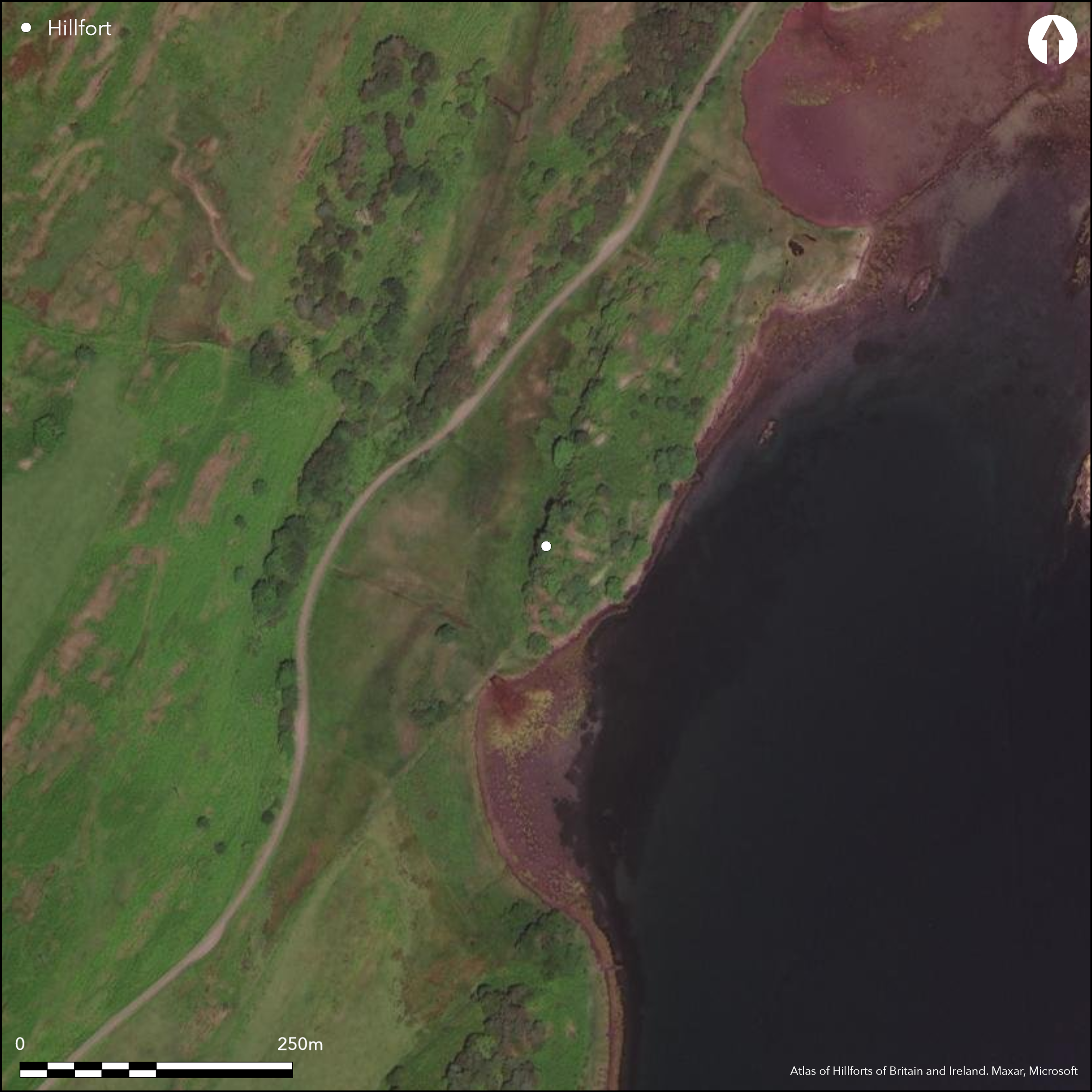
This complex fortification has a long history of occupation, the latter stages of which have been shown by excavation to span the medieval and post-medieval periods (WoSAS Event ID: 4947; Kilmartin House Data Structure Report). At its core, however, there is an oval dun which shows evidence of reconstruction and is overlain by two rectangular buildings, surrounded by a series of more extensive defensive enclosures. In its latest form the dun measures about 15.5m by 12m within a well-preserved wall about 2.8m in thickness, and there is an entrance protected by an outer hornwork on the SSW. The wall of the rectilinear outer enclosure may have sprung from the dun on the E and can be traced around the lip of the steep and precipitous flanks of the hillock, probably returning to the the foot of the outcrops below the dun wall on the S and enclosing an area measuring about 48m from NE to SW by a maximum of 28m transversely (0.12ha) at the NE end, where there is also a well-preserved entrance; the wall varies between 1.5m and 3m in thickness, with well-preserved runs of outer face, and the entrance is 1.75m wide and the length of the passage has been increased to 2.7m by the addition of two external buttresses. An additional wall springing from the W angle of this enclosure takes in a lower terrace at the SW, while other fragments of walls may be seen on the S, NW and NE. While the outer enclosure has been thought to be an addition to the dun, the superficial resemblance to a nuclear fort has lead to its inclusion here
Citizen Science: ✗
Reliability of Data: Confirmed
Reliability of Interpretation: Confirmed
X: -629351 Y: 7558109 (EPSG: 3857)
Longitude: -5.653559873614057 Latitude: 55.998461962952106 (EPSG:4326)
Country: Scotland
Current County or Unitary Authority: Argyll & Bute
Historic County: Argyll
Current Parish/Community/Council/Townland: North Knapdale
None
| Extant | ✓ |
| Cropmark | ✗ |
| Likely Destroyed | ✗ |
None
| Woodland | ✗ |
| Commercial Forestry Plantation | ✗ |
| Parkland | ✗ |
| Pasture (Grazing) | ✗ |
| Arable | ✗ |
| Scrub/Bracken | ✓ |
| Bare Outcrop | ✗ |
| Heather/Moorland | ✗ |
| Heath | ✗ |
| Built-up | ✗ |
| Coastal Grassland | ✗ |
| Other | ✗ |
None
| Contour Fort | ✓ |
| Partial Contour Fort | ✗ |
| Promontory Fort | ✗ |
| Hillslope Fort | ✗ |
| Level Terrain Fort | ✗ |
| Marsh Fort | ✗ |
| Multiple Enclosure Fort | ✗ |
| Hilltop | ✗ |
| Coastal Promontory | ✗ |
| Inland Promontory | ✗ |
| Valley Bottom | ✗ |
| Knoll/Hillock/Outcrop | ✓ |
| Ridge | ✗ |
| Cliff/Plateau-edge/Scarp | ✗ |
| Hillslope | ✗ |
| Lowland | ✗ |
| Spur | ✗ |
Dominant Topographic Feature: None
| North | ✗ |
| Northeast | ✗ |
| East | ✗ |
| Southeast | ✗ |
| South | ✗ |
| Southwest | ✗ |
| West | ✗ |
| Northwest | ✗ |
| Level | ✓ |
Altitude: 15.0m
N/A
There are neither stratified artefacts nor radiocarbon dates to provide a chronology for the defences.
Reliability: D - None
| Pre 1200BC | ✗ |
| 1200BC - 800BC | ✗ |
| 800BC - 400BC | ✗ |
| 400BC - AD50 | ✗ |
| AD50 - AD400 | ✗ |
| AD400 - AD 800 | ✗ |
| Post AD800 | ✗ |
| Unknown | ✓ |
| Pre Hillfort: | None |
| Post Hillfort: | Overlain by medieval and post-medieval buildings |
None
| 1st Identified Map Depiction (1869): | Annotated Fort on 1st edition OS 6-inch map (Argyll and Bute 1873, sheet 169) |
| Other (1898): | Photograph by Erskine Beveridge (RCAHMS AG12132PO) |
| Other (1955): | Scheduled |
| Other (1957): | Visited by RCAHMS |
| Earthwork Survey (1959): | Plan (RCAHMS DC13412-13) |
| Other (1963): | Description sometime 1954-63 (Campbell and Sandeman 1962, 50-1) |
| Other (1973): | Visited by OS |
| Other (1977): | Surveyed 1:10,000 by the OS |
| Earthwork Survey (1982): | Plan and description (RCAHMS 1988, 189-90, no.311; RCAHMS DC13414-15) |
| Excavation (2012): | Evaluation Kilmartin House Museum (Regan, R; WoSAS Event ID: 4947 ) |
Featureless apart from later rectangular buildings
None
| None | ✓ |
| Spring | ✗ |
| Stream | ✗ |
| Pool | ✗ |
| Flush | ✗ |
| Well | ✗ |
| Other | ✗ |
Later rectangular building overlying the dun
| No Known Features | ✗ |
| Round Stone Structures | ✗ |
| Rectangular Stone Structures | ✓ |
| Curvilinear Platforms | ✗ |
| Other Roundhouse Evidence | ✗ |
| Pits | ✗ |
| Quarry Hollows | ✗ |
| Other | ✗ |
None
| No Known Excavation | ✓ |
| Pits | ✗ |
| Postholes | ✗ |
| Roundhouses | ✗ |
| Rectangular Structures | ✗ |
| Roads/Tracks | ✗ |
| Quarry Hollows | ✗ |
| Other | ✗ |
| Nothing Found | ✗ |
None
| No Known Geophysics | ✓ |
| Pits | ✗ |
| Roundhouses | ✗ |
| Rectangular Structures | ✗ |
| Roads/Tracks | ✗ |
| Quarry Hollows | ✗ |
| Other | ✗ |
| Nothing Found | ✗ |
None
| No Known Finds | ✓ |
| Pottery | ✗ |
| Metal | ✗ |
| Metalworking | ✗ |
| Human Bones | ✗ |
| Animal Bones | ✗ |
| Lithics | ✗ |
| Environmental | ✗ |
| Other | ✗ |
NO APPARENT FEATURES
| APs Not Checked | ✗ |
| None | ✓ |
| Roundhouses | ✗ |
| Rectangular Structures | ✗ |
| Pits | ✗ |
| Postholes | ✗ |
| Roads/Tracks | ✗ |
| Other | ✗ |
See main summary
| 1: | several robbed gaps elsewhere |
| 2: | Excludes the internal dun |
Guard Chambers: ✗
Chevaux de Frise: ✗
| 1. Simple Gap (North east): | Passage through wall extended by later external buttresses |
Inner dun and an outer enclosure with additional fragments of other walls
| Area 1: | 0.12ha. |
| Total: | 0.12ha. |
Total Footprint Area: Noneha.
None
| ✓ | The outer enclosure has been taken here to represent the main fort, but given the analogy with nuclear forts the numbers of ramparts include the central dun |
| ✓ | None |
| NE Quadrant: | 2 |
| SE Quadrant: | 2 |
| SW Quadrant: | 3 |
| NW Quadrant: | 2 |
| Total: | 3 |
| Partial Univallate | ✗ |
| Univallate | ✗ |
| Partial Bivallate | ✓ |
| Bivallate | ✗ |
| Partial Multivallate | ✓ |
| Multivallate | ✗ |
| Unknown | ✗ |
| Partial Univallate | ✗ |
| Univallate | ✓ |
| Partial Bivallate | ✗ |
| Bivallate | ✗ |
| Partial Multivallate | ✗ |
| Multivallate | ✗ |
None
| None | ✗ |
| Earthen Bank | ✗ |
| Stone Wall | ✓ |
| Rubble | ✗ |
| Wall-walk | ✗ |
| Evidence of Timber | ✗ |
| Vitrification | ✗ |
| Other Burning | ✗ |
| Palisade | ✗ |
| Counter Scarp Bank | ✗ |
| Berm | ✗ |
| Unfinished | ✗ |
| Other | ✗ |
None
| None | ✗ |
| Earthen Bank | ✗ |
| Stone Wall | ✗ |
| Murus Duplex | ✗ |
| Timber-framed | ✗ |
| Timber-laced | ✗ |
| Vitrification | ✗ |
| Other Burning | ✗ |
| Palisade | ✗ |
| Counter Scarp Bank | ✗ |
| Berm | ✗ |
| Unfinished | ✗ |
| No Known Excavation | ✓ |
| Other | ✗ |
| ✗ | None |
| ✗ | None |
Number of Ditches: None
| ✗ | None |
Campbell and Sandeman, M and M (1962) 'Mid Argyll: an archaeological survey', Proc Soc Antiq Scot 95 (1961-2), 1-125
RCAHMS (1988) The Royal Commission on the Ancient and Historical Monuments of Scotland. Argyll: an inventory of the monuments volume 6: Mid-Argyll and Cowal, prehistoric and early historic monuments. HMSO: Edinburgh
Atlas of Hillforts:
Wikidata:
This work is licensed under CC BY-SA 4.0![]()
![]()
![]() and should be cited as:
and should be cited as:
Lock, Gary and Ralston, Ian. 2024. Atlas of Hillforts of Britain and Ireland. Available at: https://hillforts.arch.ox.ac.uk
Document Version 1.1