Satellite Imagery
Satellite Imagery
HER: The West of Scotland Archaeology Service 4040 (None)
NMR: NR 89 NW 10 (39450)
SM: 240
NGR: NR 8029 9597
X: 180290 Y: 695970 (OSGB36)
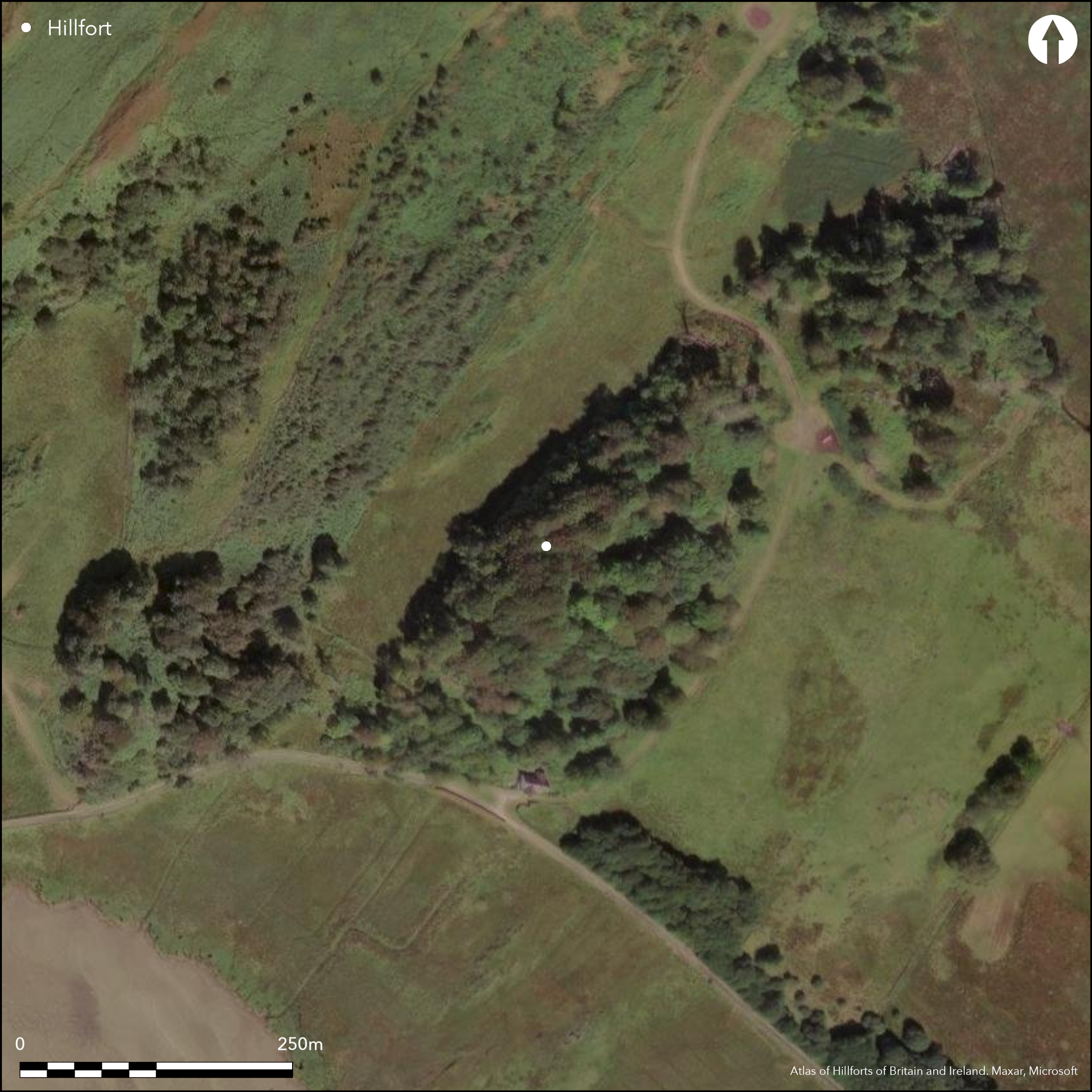
Occupying the summit of a low-lying ridge, the defences of this fort comprise two elements: an inner enclosure on the very summit; and an outer enclosure taking in a larger area following a natural shoulder lower down the slope. The inner enclosure measures 45m from NNE to SSW by 27m transversely (0.09ha) within a band of rubble about 2.5m in thickness; extensive vitrifaction can be seen along the inner margin of the rubble spread round the N and W, and two short runs of outer face are also visible on the W, in one place standing 1.3m high in three courses. Elsewhere the line of the outer face was traced in excavations carried out in 1904; though no trace of the inner face was located. A gap in the wall on the NW possibly marks the position of the entrance. The outer enclosure describes a D-shape on plan, backing onto the cliff-edge on the NW and measuring about 83m from NE to SW by 46m transversely within a heavily-robbed wall reduced to a band of rubble about 2m in thickness, with a single run of outer face exposed on the SW; its core contains numerous fragments of vitrified stone, probably indicating that it was constructed or at the very least rebuilt as a free-standing enclosure after the fire that destroyed the inner enclosure. The cliff-edge on the NW seems to have provided sufficient protection to this enclosure, but on the SW there are also traces of two robbed outer walls, and likewise there were probably outer lines on the NE.
Citizen Science: ✗
Reliability of Data: Confirmed
Reliability of Interpretation: Confirmed
X: -616138 Y: 7579519 (EPSG: 3857)
Longitude: -5.534861171294817 Latitude: 56.105864327124216 (EPSG:4326)
Country: Scotland
Current County or Unitary Authority: Argyll & Bute
Historic County: Argyll
Current Parish/Community/Council/Townland: Kilmartin
None
| Extant | ✓ |
| Cropmark | ✗ |
| Likely Destroyed | ✗ |
None
| Woodland | ✓ |
| Commercial Forestry Plantation | ✗ |
| Parkland | ✗ |
| Pasture (Grazing) | ✗ |
| Arable | ✗ |
| Scrub/Bracken | ✓ |
| Bare Outcrop | ✗ |
| Heather/Moorland | ✗ |
| Heath | ✗ |
| Built-up | ✗ |
| Coastal Grassland | ✗ |
| Other | ✗ |
None
| Contour Fort | ✓ |
| Partial Contour Fort | ✗ |
| Promontory Fort | ✗ |
| Hillslope Fort | ✗ |
| Level Terrain Fort | ✗ |
| Marsh Fort | ✗ |
| Multiple Enclosure Fort | ✓ |
| Hilltop | ✓ |
| Coastal Promontory | ✗ |
| Inland Promontory | ✗ |
| Valley Bottom | ✗ |
| Knoll/Hillock/Outcrop | ✗ |
| Ridge | ✗ |
| Cliff/Plateau-edge/Scarp | ✗ |
| Hillslope | ✗ |
| Lowland | ✗ |
| Spur | ✗ |
Dominant Topographic Feature: None
| North | ✗ |
| Northeast | ✗ |
| East | ✗ |
| Southeast | ✗ |
| South | ✗ |
| Southwest | ✗ |
| West | ✗ |
| Northwest | ✗ |
| Level | ✓ |
Altitude: 30.0m
N/A
Although undated, the thirty-six saddle querns recovered in the excavations of 1904, and the complete absence of rotary querns, probably indicates an early to mid Iron Age date.
Reliability: D - None
| Pre 1200BC | ✗ |
| 1200BC - 800BC | ✗ |
| 800BC - 400BC | ✗ |
| 400BC - AD50 | ✗ |
| AD50 - AD400 | ✗ |
| AD400 - AD 800 | ✗ |
| Post AD800 | ✗ |
| Unknown | ✓ |
| Pre Hillfort: | Lithics |
| Post Hillfort: | Heavy robbing |
| Artefactual: | None |
None
| 1st Identified Map Depiction (1865): | Annotated Fort (vitrified) on the 1st edition OS 25-inch map (Argyll and Bute 1874, sheet 149.10) |
| Excavation (1904): | Society of Antiquaries programme directed by David Christison (1905, 270-85) |
| Other (1933): | Scheduled |
| Other (1963): | Description (Campbell and Sandeman 1962, 55, 118) |
| Other (1973): | resurveyed at 1:2500 by the OS |
| Other (1977): | Surveyed at 1:10,000 by the OS |
| Earthwork Survey (1981): | Plan and description (RCAHMS 1988, 164-5, no.257: RCAHMS DC13307) |
| Other (2013): | Re-Scheduled |
Featureless
None
| None | ✓ |
| Spring | ✗ |
| Stream | ✗ |
| Pool | ✗ |
| Flush | ✗ |
| Well | ✗ |
| Other | ✗ |
None
| No Known Features | ✓ |
| Round Stone Structures | ✗ |
| Rectangular Stone Structures | ✗ |
| Curvilinear Platforms | ✗ |
| Other Roundhouse Evidence | ✗ |
| Pits | ✗ |
| Quarry Hollows | ✗ |
| Other | ✗ |
None
| No Known Excavation | ✗ |
| Pits | ✗ |
| Postholes | ✗ |
| Roundhouses | ✗ |
| Rectangular Structures | ✗ |
| Roads/Tracks | ✗ |
| Quarry Hollows | ✗ |
| Other | ✗ |
| Nothing Found | ✓ |
None
| No Known Geophysics | ✓ |
| Pits | ✗ |
| Roundhouses | ✗ |
| Rectangular Structures | ✗ |
| Roads/Tracks | ✗ |
| Quarry Hollows | ✗ |
| Other | ✗ |
| Nothing Found | ✗ |
Finds from the excavations of 1904 include thirty-six saddle querns, three flint scapers and several flakes and cores, a piece of lignite, and several hammerstones and polishers.
| No Known Finds | ✗ |
| Pottery | ✗ |
| Metal | ✗ |
| Metalworking | ✗ |
| Human Bones | ✗ |
| Animal Bones | ✗ |
| Lithics | ✓ |
| Environmental | ✗ |
| Other | ✗ |
obscured by trees
| APs Not Checked | ✗ |
| None | ✓ |
| Roundhouses | ✗ |
| Rectangular Structures | ✗ |
| Pits | ✗ |
| Postholes | ✗ |
| Roads/Tracks | ✗ |
| Other | ✗ |
See main summary
| 1: | None |
| 2: | None |
Guard Chambers: ✗
Chevaux de Frise: ✗
| 1. Simple Gap (North west): | None |
Inner and outer enclosure, the former with a continuous vitrified wall and the latter possibly later with up to three lines of defence backing onto the cliff edge
| Area 1: | 0.09ha. |
| Area 2: | 0.3ha. |
| Total: | 0.3ha. |
Total Footprint Area: Noneha.
None
| ✗ | None |
| ✓ | None |
| NE Quadrant: | 3 |
| SE Quadrant: | 2 |
| SW Quadrant: | 4 |
| NW Quadrant: | 1 |
| Total: | 4 |
| Partial Univallate | ✓ |
| Univallate | ✗ |
| Partial Bivallate | ✓ |
| Bivallate | ✗ |
| Partial Multivallate | ✓ |
| Multivallate | ✗ |
| Unknown | ✗ |
| Partial Univallate | ✗ |
| Univallate | ✓ |
| Partial Bivallate | ✓ |
| Bivallate | ✗ |
| Partial Multivallate | ✗ |
| Multivallate | ✗ |
None
| None | ✗ |
| Earthen Bank | ✗ |
| Stone Wall | ✓ |
| Rubble | ✗ |
| Wall-walk | ✗ |
| Evidence of Timber | ✗ |
| Vitrification | ✓ |
| Other Burning | ✗ |
| Palisade | ✗ |
| Counter Scarp Bank | ✗ |
| Berm | ✗ |
| Unfinished | ✗ |
| Other | ✗ |
Inner face identified
| None | ✗ |
| Earthen Bank | ✗ |
| Stone Wall | ✓ |
| Murus Duplex | ✗ |
| Timber-framed | ✗ |
| Timber-laced | ✗ |
| Vitrification | ✓ |
| Other Burning | ✗ |
| Palisade | ✗ |
| Counter Scarp Bank | ✗ |
| Berm | ✗ |
| Unfinished | ✗ |
| No Known Excavation | ✗ |
| Other | ✗ |
| ✗ | None |
| ✗ | None |
Number of Ditches: None
| ✗ | Unclear whether the outer enclosure is an annexe or a free-standing defence |
Campbell and Sandeman, M and M (1962) 'Mid Argyll: an archaeological survey', Proc Soc Antiq Scot 95 (1961-2), 1-125
Christison, D (1905) 'Report on the Society's excavations of forts on the Poltalloch Estate, Argyll, in 1904-5'. Proc Soc Antiq Scot 39 (1904-5), 259-322
RCAHMS (1988) The Royal Commission on the Ancient and Historical Monuments of Scotland. Argyll: an inventory of the monuments volume 6: Mid-Argyll and Cowal, prehistoric and early historic monuments. HMSO: Edinburgh
Atlas of Hillforts:
Wikidata:
This work is licensed under CC BY-SA 4.0![]()
![]()
![]() and should be cited as:
and should be cited as:
Lock, Gary and Ralston, Ian. 2024. Atlas of Hillforts of Britain and Ireland. Available at: https://hillforts.arch.ox.ac.uk
Document Version 1.1