Satellite Imagery
Satellite Imagery
HER: The West of Scotland Archaeology Service 6 (None)
NMR: NL 93 NE 5 (21412)
SM: None
NGR: NL 9740 3850
X: 97400 Y: 738500 (OSGB36)
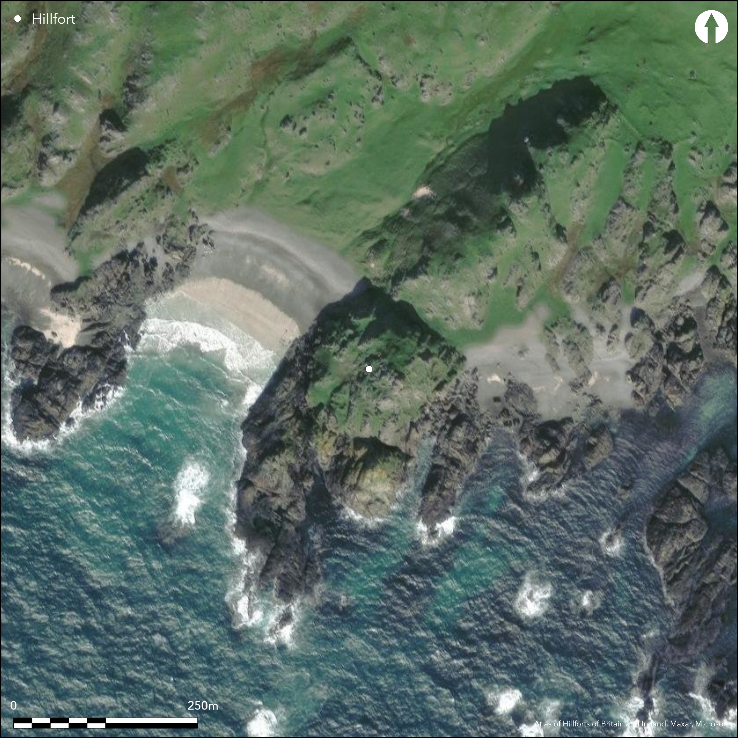
This fort occupies a precipitous headland on the southernmost coast of Tiree, which rises in a series of terraces to a rock boss 4-5m in height on the summit. On the N of this boss, there seems to have been a relatively small fortified enclosure, though its perimeter, which is reduced a few bands of rubble with several runs of outer facing stones, in one place standing between 0.8m and 1.1m high, displays little coherence on plan (see RCAHMS 1980, 80-1, no.143, fig 67). Elsewhere there are a series of ruined walls that block gullies and extend along the edges of terraces to form an enclosure measuring about 90m square (0.72ha), on the NW following the leading edges of no less than three separate terraces stepping down this flank of the promontory. The entrance into this outer enclosure is not visible, but access to the summit of the headland was probably gained most easily by mounting a series of interconnected terraces on this side, perhaps accounting for the complexity of the defences here. The interior, much of which is made up of bare rock, is featureless, though there are several grassy natural platforms amongst the outcrops. Erskine Beveridge found midden material containing bones, shells, pottery and hammer-stones here (1903, 90-3).
Citizen Science: ✗
Reliability of Data: Confirmed
Reliability of Interpretation: Confirmed
X: -769420 Y: 7646778 (EPSG: 3857)
Longitude: -6.911821601204205 Latitude: 56.4413295110297 (EPSG:4326)
Country: Scotland
Current County or Unitary Authority: Argyll & Bute
Historic County: Argyll
Current Parish/Community/Council/Townland: Tiree
None
| Extant | ✓ |
| Cropmark | ✗ |
| Likely Destroyed | ✗ |
None
| Woodland | ✗ |
| Commercial Forestry Plantation | ✗ |
| Parkland | ✗ |
| Pasture (Grazing) | ✓ |
| Arable | ✗ |
| Scrub/Bracken | ✗ |
| Bare Outcrop | ✗ |
| Heather/Moorland | ✓ |
| Heath | ✗ |
| Built-up | ✗ |
| Coastal Grassland | ✓ |
| Other | ✗ |
None
| Contour Fort | ✗ |
| Partial Contour Fort | ✗ |
| Promontory Fort | ✓ |
| Hillslope Fort | ✗ |
| Level Terrain Fort | ✗ |
| Marsh Fort | ✗ |
| Multiple Enclosure Fort | ✗ |
| Hilltop | ✗ |
| Coastal Promontory | ✓ |
| Inland Promontory | ✗ |
| Valley Bottom | ✗ |
| Knoll/Hillock/Outcrop | ✗ |
| Ridge | ✗ |
| Cliff/Plateau-edge/Scarp | ✗ |
| Hillslope | ✗ |
| Lowland | ✗ |
| Spur | ✗ |
Dominant Topographic Feature: None
| North | ✗ |
| Northeast | ✗ |
| East | ✗ |
| Southeast | ✗ |
| South | ✗ |
| Southwest | ✗ |
| West | ✗ |
| Northwest | ✗ |
| Level | ✓ |
Altitude: 30.0m
N/A
In the absence of excavation, there are neither stratified artefacts nor radiocarbon dates to provide a chronology for the defences.
Reliability: D - None
| Pre 1200BC | ✗ |
| 1200BC - 800BC | ✗ |
| 800BC - 400BC | ✗ |
| 400BC - AD50 | ✗ |
| AD50 - AD400 | ✗ |
| AD400 - AD 800 | ✗ |
| Post AD800 | ✗ |
| Unknown | ✓ |
| Pre Hillfort: | None |
| Post Hillfort: | Old field-bank visible on a terrace low down the NW flank. |
None
| 1st Identified Map Depiction (1878): | Named in Gothic type on the 1st edition OS 25-inch map (Argyll and Bute 1882, sheet 78.15) |
| Other (1903): | Description and photographs by Erskine Beveridge 1896-1901 (1903) |
| Other (1972): | Visited by RCAHMS (RCAHMS MS 7251/7) |
| Other (1972): | Surveyed at 1:10,000 by the OS |
| Earthwork Survey (1977): | Plan and description (RCAHMS 1980, 80-1, no.143, fig 67; RCAHMS AGD 629/1-3) |
Featurelss though there are natural grassy platforms in amongst the rock outcrops
None
| None | ✓ |
| Spring | ✗ |
| Stream | ✗ |
| Pool | ✗ |
| Flush | ✗ |
| Well | ✗ |
| Other | ✗ |
None
| No Known Features | ✓ |
| Round Stone Structures | ✗ |
| Rectangular Stone Structures | ✗ |
| Curvilinear Platforms | ✗ |
| Other Roundhouse Evidence | ✗ |
| Pits | ✗ |
| Quarry Hollows | ✗ |
| Other | ✗ |
None
| No Known Excavation | ✓ |
| Pits | ✗ |
| Postholes | ✗ |
| Roundhouses | ✗ |
| Rectangular Structures | ✗ |
| Roads/Tracks | ✗ |
| Quarry Hollows | ✗ |
| Other | ✗ |
| Nothing Found | ✗ |
None
| No Known Geophysics | ✓ |
| Pits | ✗ |
| Roundhouses | ✗ |
| Rectangular Structures | ✗ |
| Roads/Tracks | ✗ |
| Quarry Hollows | ✗ |
| Other | ✗ |
| Nothing Found | ✗ |
Erskine Beveridge found midden material containing bones, shells, pottery and hammer-stones here (1903, 90-3)
| No Known Finds | ✗ |
| Pottery | ✓ |
| Metal | ✗ |
| Metalworking | ✗ |
| Human Bones | ✗ |
| Animal Bones | ✓ |
| Lithics | ✓ |
| Environmental | ✗ |
| Other | ✗ |
NO APPARENT FEATURES
| APs Not Checked | ✓ |
| None | ✗ |
| Roundhouses | ✗ |
| Rectangular Structures | ✗ |
| Pits | ✗ |
| Postholes | ✗ |
| Roads/Tracks | ✗ |
| Other | ✗ |
See main summary
| 0: | None |
| 2: | Not known |
Guard Chambers: ✗
Chevaux de Frise: ✗
Remains of a complex of ramparts blocking gullies and linking outcrops and cliff-edges
| Area 1: | 0.72ha. |
| Total: | 0.72ha. |
Total Footprint Area: 0.8ha.
None
| ✗ | This configuration does not include what appears to have been a much smaller defensive enclosure on the upper level of the promontory |
| ✓ | None |
| NE Quadrant: | 1 |
| SE Quadrant: | 1 |
| SW Quadrant: | 1 |
| NW Quadrant: | 3 |
| Total: | 3 |
| Partial Univallate | ✓ |
| Univallate | ✗ |
| Partial Bivallate | ✗ |
| Bivallate | ✗ |
| Partial Multivallate | ✓ |
| Multivallate | ✗ |
| Unknown | ✗ |
| Partial Univallate | ✗ |
| Univallate | ✗ |
| Partial Bivallate | ✗ |
| Bivallate | ✗ |
| Partial Multivallate | ✗ |
| Multivallate | ✗ |
None
| None | ✗ |
| Earthen Bank | ✗ |
| Stone Wall | ✓ |
| Rubble | ✗ |
| Wall-walk | ✗ |
| Evidence of Timber | ✗ |
| Vitrification | ✗ |
| Other Burning | ✗ |
| Palisade | ✗ |
| Counter Scarp Bank | ✗ |
| Berm | ✗ |
| Unfinished | ✗ |
| Other | ✗ |
None
| None | ✗ |
| Earthen Bank | ✗ |
| Stone Wall | ✗ |
| Murus Duplex | ✗ |
| Timber-framed | ✗ |
| Timber-laced | ✗ |
| Vitrification | ✗ |
| Other Burning | ✗ |
| Palisade | ✗ |
| Counter Scarp Bank | ✗ |
| Berm | ✗ |
| Unfinished | ✗ |
| No Known Excavation | ✓ |
| Other | ✗ |
| ✗ | None |
| ✗ | None |
Number of Ditches: None
| ✗ | None |
Beveridge, E (1903) Coll and Tiree: their prehistoric forts and ecclesiastical antiquities with notices of ancient remains in the Treshnish Isles. Edinburgh
RCAHMS (1980) The Royal Commission on the Ancient and Historical Monuments of Scotland. Argyll: an inventory of the monuments volume 3: Mull, Tiree, Coll and Northern Argyll (excluding the early medieval and later monuments of Iona). HMSO: Edinburgh
Atlas of Hillforts:
Wikidata:
This work is licensed under CC BY-SA 4.0![]()
![]()
![]() and should be cited as:
and should be cited as:
Lock, Gary and Ralston, Ian. 2024. Atlas of Hillforts of Britain and Ireland. Available at: https://hillforts.arch.ox.ac.uk
Document Version 1.1