Satellite Imagery
Satellite Imagery
HER: The West of Scotland Archaeology Service 77 (None)
NMR: NL 94 SW 8 (21483)
SM: 6903
NGR: NL 9350 4086
X: 93500 Y: 740860 (OSGB36)
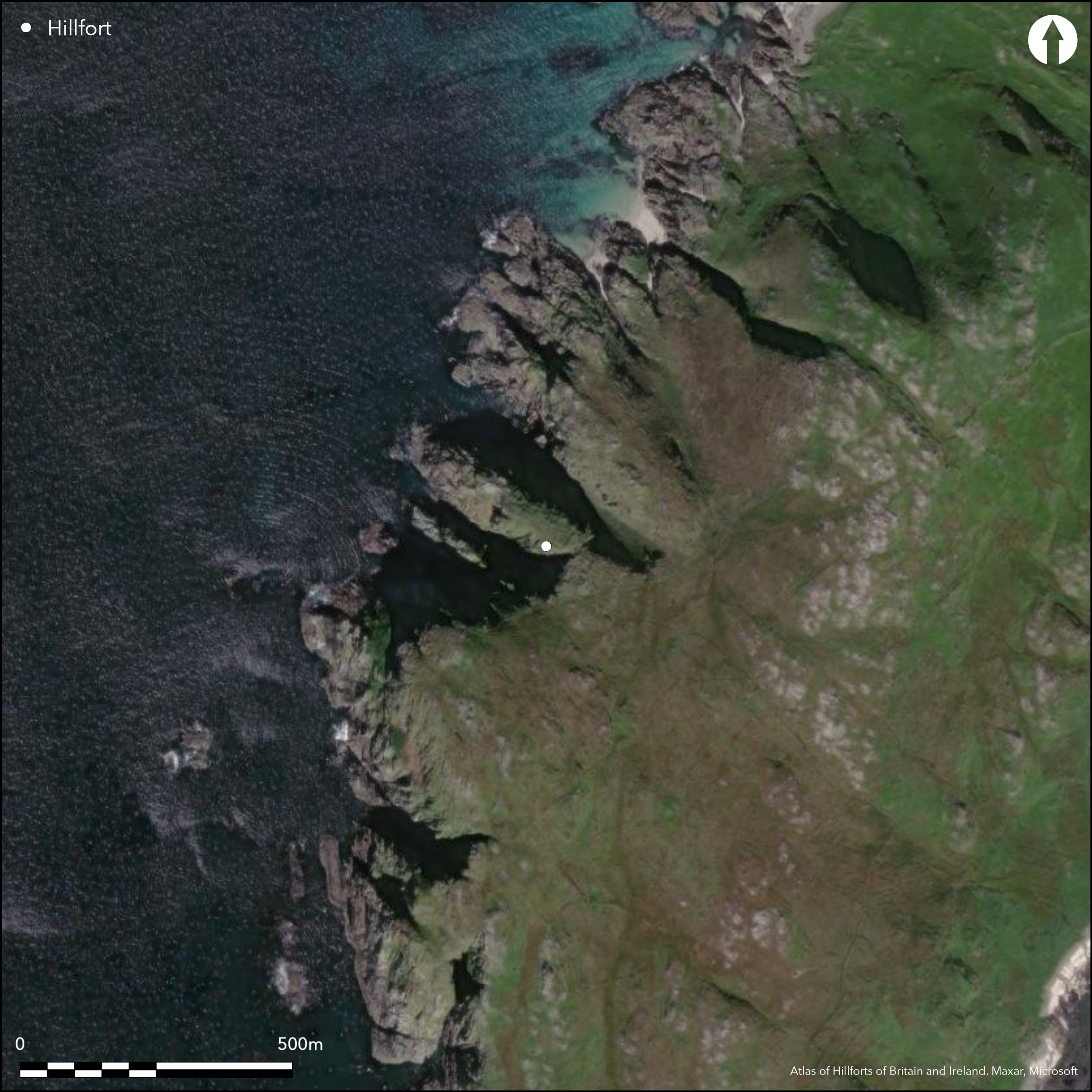
This fort occupies the summit of a coastal promontory, which projects beyond a narrow neck from the cliffs on the W coast of Tiree. The main defence is provided by a single wall, which crosses over a low rocky knoll overlooking the neck and evidently extended down both the N and S margins of the summit to enclose an area measuring about 55m from ESE to WNW by 30m transversely (0.13ha); the promontory itself extends considerably further into the sea, descending in a series of terraces and outcrops to a rocky wave-swept shore. The wall has been heavily reduced by robbing and erosion, but an exposed section on the NNE observed by RCAHMS investigators in 1975 revealed that it was about 1.5m in thickness at that point, with midden containing a sherd of coarse pottery built up against the inner face; elsewhere along the margins it has been reduced to little more than a scarp with occasional outer facing-stones, while in the better preserved E sector one run of outer face still stands 1.1m high in five courses. At the entrance, which lies at the N margin of the promontory on the E, the terminals of the walls appear staggered, and there are traces of what may be rough outworks to either side, though there are also other fragments of walling around the foot of the knoll at this end of the fort the purpose of which is not fully understood. Within the interior there are four shallow depressions edged round with set stones; two are small oval structures about 4m across, while the other two are larger enclosures; while their date and purpose are unknown, at least one of the enclosures set immediately to the rear of the wall on the knoll is secondary.
Citizen Science: ✗
Reliability of Data: Confirmed
Reliability of Interpretation: Confirmed
X: -776744 Y: 7650526 (EPSG: 3857)
Longitude: -6.9776061681997446 Latitude: 56.45993627294102 (EPSG:4326)
Country: Scotland
Current County or Unitary Authority: Argyll & Bute
Historic County: Argyll
Current Parish/Community/Council/Townland: Tiree
None
| Extant | ✓ |
| Cropmark | ✗ |
| Likely Destroyed | ✗ |
None
| Woodland | ✗ |
| Commercial Forestry Plantation | ✗ |
| Parkland | ✗ |
| Pasture (Grazing) | ✓ |
| Arable | ✗ |
| Scrub/Bracken | ✗ |
| Bare Outcrop | ✗ |
| Heather/Moorland | ✓ |
| Heath | ✗ |
| Built-up | ✗ |
| Coastal Grassland | ✓ |
| Other | ✗ |
None
| Contour Fort | ✗ |
| Partial Contour Fort | ✗ |
| Promontory Fort | ✓ |
| Hillslope Fort | ✗ |
| Level Terrain Fort | ✗ |
| Marsh Fort | ✗ |
| Multiple Enclosure Fort | ✗ |
| Hilltop | ✗ |
| Coastal Promontory | ✓ |
| Inland Promontory | ✗ |
| Valley Bottom | ✗ |
| Knoll/Hillock/Outcrop | ✗ |
| Ridge | ✗ |
| Cliff/Plateau-edge/Scarp | ✗ |
| Hillslope | ✗ |
| Lowland | ✗ |
| Spur | ✗ |
Dominant Topographic Feature: None
| North | ✗ |
| Northeast | ✗ |
| East | ✗ |
| Southeast | ✗ |
| South | ✗ |
| Southwest | ✗ |
| West | ✗ |
| Northwest | ✗ |
| Level | ✓ |
Altitude: 30.0m
N/A
Pottery recovered
Reliability: D - None
| Pre 1200BC | ✗ |
| 1200BC - 800BC | ✗ |
| 800BC - 400BC | ✗ |
| 400BC - AD50 | ✗ |
| AD50 - AD400 | ✗ |
| AD400 - AD 800 | ✗ |
| Post AD800 | ✗ |
| Unknown | ✓ |
| Pre Hillfort: | None |
| Post Hillfort: | Structures and enclosures in the interior are probably secondary |
| Artefactual: | None |
None
| 1st Identified Map Depiction (1878): | Named in Gothic type on the 1st edition OS 25-inch map (Argyll and Bute 1882, sheet 78.5) |
| Other (1903): | Description by Erskine Beveridge 1896-1901 (1903, 97-9) |
| Other (1963): | Euan Mackie recovered sherds from the midden (1963, 21) |
| Other (1972): | Surveyed at 1:10,000 by the OS |
| Earthwork Survey (1975): | Plan and description (RCAHMS 1980, 82, no.144, fig 69; RCAHMS AGD 631/1-2) |
| Other (1997): | Scheduled |
Two small oval structures and two slightly larger enclosures
None
| None | ✓ |
| Spring | ✗ |
| Stream | ✗ |
| Pool | ✗ |
| Flush | ✗ |
| Well | ✗ |
| Other | ✗ |
Two small oval structures and two slightly larger enclosures; they are probably secondary.
| No Known Features | ✗ |
| Round Stone Structures | ✓ |
| Rectangular Stone Structures | ✗ |
| Curvilinear Platforms | ✗ |
| Other Roundhouse Evidence | ✗ |
| Pits | ✗ |
| Quarry Hollows | ✗ |
| Other | ✓ |
None
| No Known Excavation | ✓ |
| Pits | ✗ |
| Postholes | ✗ |
| Roundhouses | ✗ |
| Rectangular Structures | ✗ |
| Roads/Tracks | ✗ |
| Quarry Hollows | ✗ |
| Other | ✗ |
| Nothing Found | ✗ |
None
| No Known Geophysics | ✓ |
| Pits | ✗ |
| Roundhouses | ✗ |
| Rectangular Structures | ✗ |
| Roads/Tracks | ✗ |
| Quarry Hollows | ✗ |
| Other | ✗ |
| Nothing Found | ✗ |
None
| No Known Finds | ✓ |
| Pottery | ✗ |
| Metal | ✗ |
| Metalworking | ✗ |
| Human Bones | ✗ |
| Animal Bones | ✗ |
| Lithics | ✗ |
| Environmental | ✗ |
| Other | ✗ |
NO APPARENT FEATURES
| APs Not Checked | ✓ |
| None | ✗ |
| Roundhouses | ✗ |
| Rectangular Structures | ✗ |
| Pits | ✗ |
| Postholes | ✗ |
| Roads/Tracks | ✗ |
| Other | ✗ |
See main summary
| 1: | Additional gaps all round the circuit |
| 2: | None |
Guard Chambers: ✗
Chevaux de Frise: ✗
| 1. Over-lapping (East): | None |
Single wall, possibly continuous
| Area 1: | 0.13ha. |
| Total: | 0.13ha. |
Total Footprint Area: 0.6ha.
None
| ✗ | The overall footprint includes the rocky descent down to the shore |
| ✗ | Possibly originally continuous |
| NE Quadrant: | 1 |
| SE Quadrant: | 1 |
| SW Quadrant: | 1 |
| NW Quadrant: | 0 |
| Total: | 1 |
| Partial Univallate | ✓ |
| Univallate | ✗ |
| Partial Bivallate | ✗ |
| Bivallate | ✗ |
| Partial Multivallate | ✗ |
| Multivallate | ✗ |
| Unknown | ✗ |
| Partial Univallate | ✗ |
| Univallate | ✗ |
| Partial Bivallate | ✗ |
| Bivallate | ✗ |
| Partial Multivallate | ✗ |
| Multivallate | ✗ |
None
| None | ✗ |
| Earthen Bank | ✗ |
| Stone Wall | ✓ |
| Rubble | ✗ |
| Wall-walk | ✗ |
| Evidence of Timber | ✗ |
| Vitrification | ✗ |
| Other Burning | ✗ |
| Palisade | ✗ |
| Counter Scarp Bank | ✗ |
| Berm | ✗ |
| Unfinished | ✗ |
| Other | ✗ |
None
| None | ✗ |
| Earthen Bank | ✗ |
| Stone Wall | ✗ |
| Murus Duplex | ✗ |
| Timber-framed | ✗ |
| Timber-laced | ✗ |
| Vitrification | ✗ |
| Other Burning | ✗ |
| Palisade | ✗ |
| Counter Scarp Bank | ✗ |
| Berm | ✗ |
| Unfinished | ✗ |
| No Known Excavation | ✓ |
| Other | ✗ |
| ✗ | None |
| ✗ | None |
Number of Ditches: None
| ✗ | None |
Beveridge, E (1903) Coll and Tiree: their prehistoric forts and ecclesiastical antiquities with notices of ancient remains in the Treshnish Isles. Edinburgh
MacKie, E W (1963) 'Tiree. Dun Mhor Vaul; Dun Beg Vaul; Dun Boraige Mor; Dun Hiader; Dun Ibrig; Dun Mor a' Chaolais; Dun Nan Gall'. Disc Exc Scot 1963, 21
RCAHMS (1980) The Royal Commission on the Ancient and Historical Monuments of Scotland. Argyll: an inventory of the monuments volume 3: Mull, Tiree, Coll and Northern Argyll (excluding the early medieval and later monuments of Iona). HMSO: Edinburgh
Atlas of Hillforts:
Wikidata:
This work is licensed under CC BY-SA 4.0![]()
![]()
![]() and should be cited as:
and should be cited as:
Lock, Gary and Ralston, Ian. 2024. Atlas of Hillforts of Britain and Ireland. Available at: https://hillforts.arch.ox.ac.uk
Document Version 1.1