Satellite Imagery
Satellite Imagery
HER: Highland HER MHG150 (None)
NMR: NM 67 SE 4 (22514)
SM: 7800
NGR: NM 6622 7018
X: 166220 Y: 770180 (OSGB36)
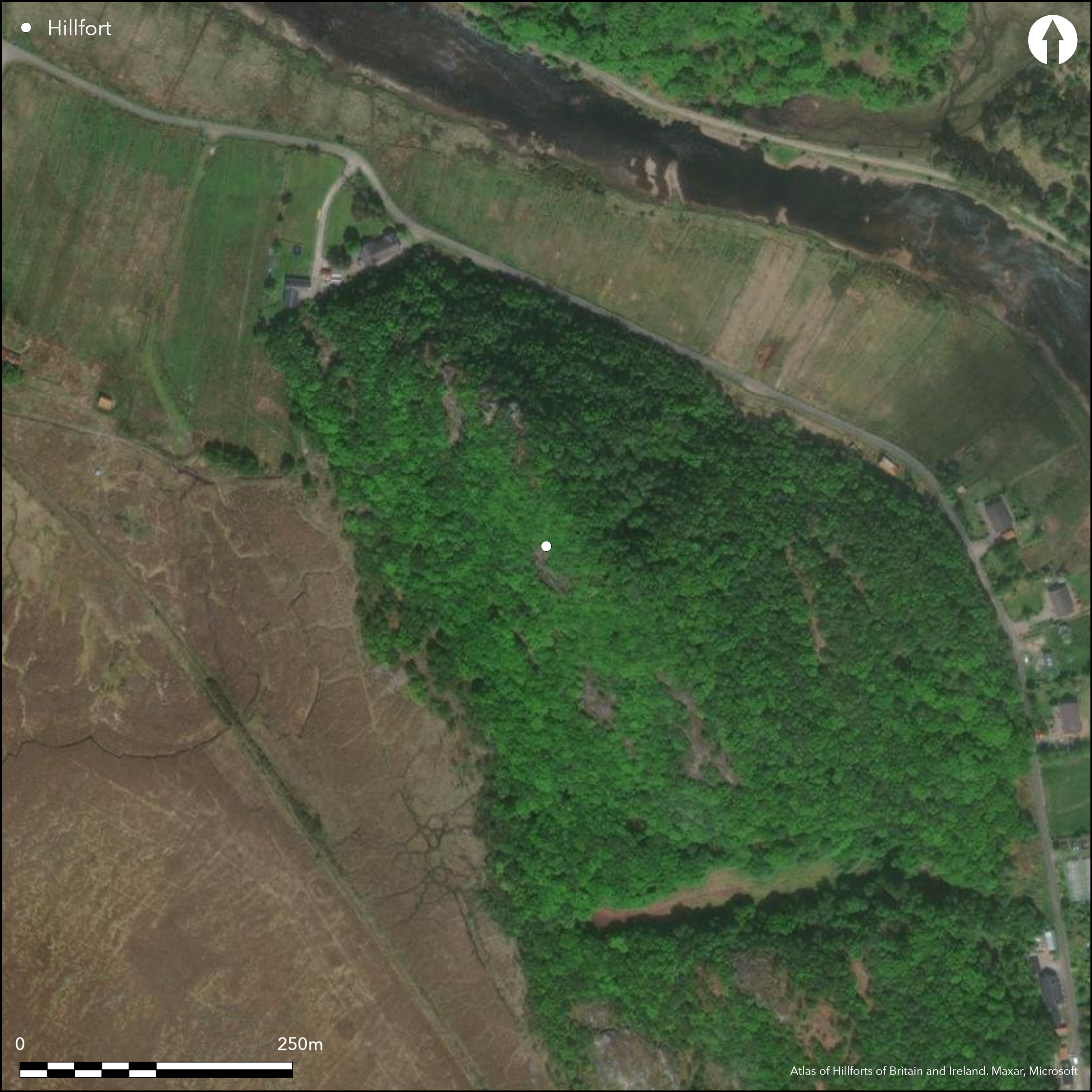
This remarkable fortification encloses the spine of a narrow ridge from which boulder-studded slopes fall away steeply in every direction. Three elements in the defences may be discerned: a small dun-like enclosure measuring no more than 7.5m in diameter within a heavily vitrified wall at the NW extremity of the ridge; a long narrow enclosure with a heavily vitrified wall extending back down the crest of the ridge to the SE to enclose the summit; and an outer annexe at the SE end, with an entrance opening onto a sloping terrace that provided the only easy line of access up the SW flank of the ridge. While it is assumed that the dun overlies the vitrified wall enclosing the summit, the stratigraphic relationship is uncertain. The main enclosure measures some 90m in length from NW to SE by a maximum of 17m in breadth at its SE end, tapering back NW to little more than a narrow strip 4m broad. Several short runs of outer facing-stones can be seen and in places the vitrified core stands 2.7m high. The rocky and uneven interior is featureless and the position of the entrance is not known, though it is likely to fall at the foot of a rock-face that bisects the southern end of the interior, on its SW flank. On this side an outer wall, now reduced to a band of rubble with several runs of outer face, drops down to take in a lower terrace and return along the spine of the ridge on the E. Unlike the main enclosure, the wall of this outer enclosure shows no trace of vitrifaction, raising the possibility that either it was an addition to the fort built entirely in drystone masonry, or that it represents part of an earlier fortification taking in an larger area.
Citizen Science: ✗
Reliability of Data: Confirmed
Reliability of Interpretation: Confirmed
X: -648652 Y: 7712125 (EPSG: 3857)
Longitude: -5.82693776783962 Latitude: 56.764446630827514 (EPSG:4326)
Country: Scotland
Current County or Unitary Authority: Highland
Historic County: Argyll
Current Parish/Community/Council/Townland: Ardnamurchan
None
| Extant | ✓ |
| Cropmark | ✗ |
| Likely Destroyed | ✗ |
None
| Woodland | ✓ |
| Commercial Forestry Plantation | ✗ |
| Parkland | ✗ |
| Pasture (Grazing) | ✗ |
| Arable | ✗ |
| Scrub/Bracken | ✓ |
| Bare Outcrop | ✗ |
| Heather/Moorland | ✗ |
| Heath | ✗ |
| Built-up | ✗ |
| Coastal Grassland | ✗ |
| Other | ✗ |
None
| Contour Fort | ✓ |
| Partial Contour Fort | ✗ |
| Promontory Fort | ✗ |
| Hillslope Fort | ✗ |
| Level Terrain Fort | ✗ |
| Marsh Fort | ✗ |
| Multiple Enclosure Fort | ✗ |
| Hilltop | ✓ |
| Coastal Promontory | ✗ |
| Inland Promontory | ✗ |
| Valley Bottom | ✗ |
| Knoll/Hillock/Outcrop | ✗ |
| Ridge | ✓ |
| Cliff/Plateau-edge/Scarp | ✗ |
| Hillslope | ✗ |
| Lowland | ✗ |
| Spur | ✗ |
Dominant Topographic Feature: None
| North | ✗ |
| Northeast | ✗ |
| East | ✗ |
| Southeast | ✗ |
| South | ✗ |
| Southwest | ✗ |
| West | ✗ |
| Northwest | ✗ |
| Level | ✓ |
Altitude: 75.0m
N/A
In the absence of excavation, there are neither stratified artefacts nor radiocarbon dates to provide a chronology for the defences.
Reliability: D - None
| Pre 1200BC | ✗ |
| 1200BC - 800BC | ✗ |
| 800BC - 400BC | ✗ |
| 400BC - AD50 | ✗ |
| AD50 - AD400 | ✗ |
| AD400 - AD 800 | ✗ |
| Post AD800 | ✗ |
| Unknown | ✓ |
| Pre Hillfort: | None |
| Post Hillfort: | Possibly the construction of a dun |
Heavily wooded, the area has been photographed from the air by RCAHMS Aerial Survey Programme in 1978, 2009 and 2011. Highland HER also hold an archive of photographs.
| Other (1866): | Sections in Society of Antiquaries of Scotland collection held by RCAHMS (SAS 170; AND 270) |
| 1st Identified Map Depiction (1872): | Annotated Vitrified Fort (Site of) on the 1st edition OS 6-inch map (Argyll and Bute 1875, sheet 16) |
| Other (1970): | Surveyed at 1:10,000 by the OS |
| Earthwork Survey (1973): | Plan and description (RCAHMS 1980, 88-9, no.160, fig 84: RCAHMS AGD 645/1) |
| Other (2000): | Scheduled |
Featureless
None
| None | ✓ |
| Spring | ✗ |
| Stream | ✗ |
| Pool | ✗ |
| Flush | ✗ |
| Well | ✗ |
| Other | ✗ |
None
| No Known Features | ✓ |
| Round Stone Structures | ✗ |
| Rectangular Stone Structures | ✗ |
| Curvilinear Platforms | ✗ |
| Other Roundhouse Evidence | ✗ |
| Pits | ✗ |
| Quarry Hollows | ✗ |
| Other | ✗ |
None
| No Known Excavation | ✓ |
| Pits | ✗ |
| Postholes | ✗ |
| Roundhouses | ✗ |
| Rectangular Structures | ✗ |
| Roads/Tracks | ✗ |
| Quarry Hollows | ✗ |
| Other | ✗ |
| Nothing Found | ✗ |
None
| No Known Geophysics | ✓ |
| Pits | ✗ |
| Roundhouses | ✗ |
| Rectangular Structures | ✗ |
| Roads/Tracks | ✗ |
| Quarry Hollows | ✗ |
| Other | ✗ |
| Nothing Found | ✗ |
None
| No Known Finds | ✓ |
| Pottery | ✗ |
| Metal | ✗ |
| Metalworking | ✗ |
| Human Bones | ✗ |
| Animal Bones | ✗ |
| Lithics | ✗ |
| Environmental | ✗ |
| Other | ✗ |
NO APPARENT FEATURES
| APs Not Checked | ✗ |
| None | ✓ |
| Roundhouses | ✗ |
| Rectangular Structures | ✗ |
| Pits | ✗ |
| Postholes | ✗ |
| Roads/Tracks | ✗ |
| Other | ✗ |
See main summary
| 1: | None |
| 2: | None |
Guard Chambers: ✗
Chevaux de Frise: ✗
| 1. Simple Gap (South): | In the outer enclosure |
Continuous wall
| Area 1: | 0.12ha. |
| Total: | 0.12ha. |
Total Footprint Area: 0.18ha.
None
| ✓ | None |
| ✓ | None |
| NE Quadrant: | 1 |
| SE Quadrant: | 2 |
| SW Quadrant: | 1 |
| NW Quadrant: | 1 |
| Total: | 2 |
| Partial Univallate | ✓ |
| Univallate | ✗ |
| Partial Bivallate | ✓ |
| Bivallate | ✗ |
| Partial Multivallate | ✗ |
| Multivallate | ✗ |
| Unknown | ✗ |
| Partial Univallate | ✗ |
| Univallate | ✓ |
| Partial Bivallate | ✗ |
| Bivallate | ✗ |
| Partial Multivallate | ✗ |
| Multivallate | ✗ |
None
| None | ✗ |
| Earthen Bank | ✗ |
| Stone Wall | ✓ |
| Rubble | ✗ |
| Wall-walk | ✗ |
| Evidence of Timber | ✗ |
| Vitrification | ✓ |
| Other Burning | ✗ |
| Palisade | ✗ |
| Counter Scarp Bank | ✗ |
| Berm | ✗ |
| Unfinished | ✗ |
| Other | ✗ |
None
| None | ✗ |
| Earthen Bank | ✗ |
| Stone Wall | ✗ |
| Murus Duplex | ✗ |
| Timber-framed | ✗ |
| Timber-laced | ✗ |
| Vitrification | ✗ |
| Other Burning | ✗ |
| Palisade | ✗ |
| Counter Scarp Bank | ✗ |
| Berm | ✗ |
| Unfinished | ✗ |
| No Known Excavation | ✓ |
| Other | ✗ |
| ✗ | None |
| ✗ | None |
Number of Ditches: None
| ✓ | The outer wall encloses an area of 0.06ha on a lower terrace on the only easy line of approach. |
RCAHMS (1980) The Royal Commission on the Ancient and Historical Monuments of Scotland. Argyll: an inventory of the monuments volume 3: Mull, Tiree, Coll and Northern Argyll (excluding the early medieval and later monuments of Iona). HMSO: Edinburgh
Atlas of Hillforts:
Wikidata:
This work is licensed under CC BY-SA 4.0![]()
![]()
![]() and should be cited as:
and should be cited as:
Lock, Gary and Ralston, Ian. 2024. Atlas of Hillforts of Britain and Ireland. Available at: https://hillforts.arch.ox.ac.uk
Document Version 1.1