Satellite Imagery
Satellite Imagery
HER: The West of Scotland Archaeology Service 775 (None)
NMR: NM 70 NE 1 (22536)
SM: None
NGR: NM 7926 0796
X: 179260 Y: 707960 (OSGB36)
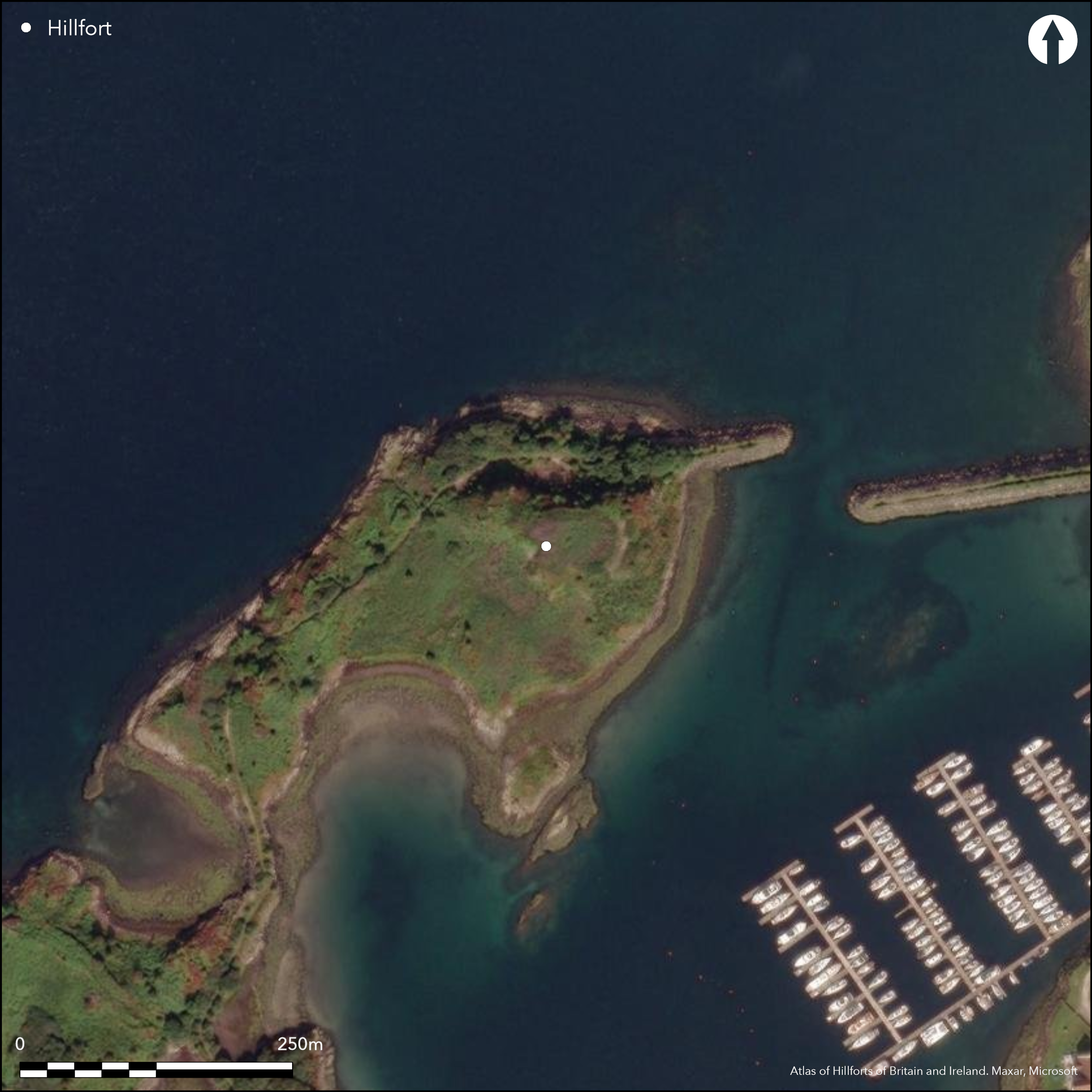
Occupying a knoll that forms the NE end of a small island that has been incorporated into the breakwater of Craobh Haven Marina, in 1983 the N and W flanks of this fort were destroyed during the construction of a causeway linking the island to the mainland. Roughly pear-shaped on plan beforehand, it measured 53m in length and tapered from 28m in breadth at the E end to some 13m at the W end (0.1ha) within a wall up to 4.5m thick. In the event, the wall survives only on the E and S, and the best preserved sectors of the outer face, which stood 1.1m high in six courses on the NNE, were removed; other short runs are visible around the E end, and there is a lump of vitrified stone in the wall on the S, where the wall takes in a shoulder of the knoll to form a re-entrant which is also the most likely position for the entrance. Apart from a small stone-founded hut thought by RCAHMS investigators to have been of relatively recent date, but now destroyed, the interior is featureless. Salvage excavations, however revealed evidence of occupation within the interior, and two radiocarbon sampes from beneath the wall returned dates in the second half of the 1st millennium BC (Nieke and Boyd 1987).
Citizen Science: ✗
Reliability of Data: Confirmed
Reliability of Interpretation: Confirmed
X: -619085 Y: 7600917 (EPSG: 3857)
Longitude: -5.561335174894712 Latitude: 56.21290773310273 (EPSG:4326)
Country: Scotland
Current County or Unitary Authority: Argyll & Bute
Historic County: Argyll
Current Parish/Community/Council/Townland: Craignish
Up to one third of the fort has been destroyed
| Extant | ✓ |
| Cropmark | ✗ |
| Likely Destroyed | ✓ |
None
| Woodland | ✗ |
| Commercial Forestry Plantation | ✗ |
| Parkland | ✗ |
| Pasture (Grazing) | ✗ |
| Arable | ✗ |
| Scrub/Bracken | ✓ |
| Bare Outcrop | ✗ |
| Heather/Moorland | ✗ |
| Heath | ✗ |
| Built-up | ✗ |
| Coastal Grassland | ✓ |
| Other | ✗ |
None
| Contour Fort | ✓ |
| Partial Contour Fort | ✗ |
| Promontory Fort | ✗ |
| Hillslope Fort | ✗ |
| Level Terrain Fort | ✗ |
| Marsh Fort | ✗ |
| Multiple Enclosure Fort | ✗ |
| Hilltop | ✗ |
| Coastal Promontory | ✗ |
| Inland Promontory | ✗ |
| Valley Bottom | ✗ |
| Knoll/Hillock/Outcrop | ✓ |
| Ridge | ✗ |
| Cliff/Plateau-edge/Scarp | ✗ |
| Hillslope | ✗ |
| Lowland | ✗ |
| Spur | ✗ |
Dominant Topographic Feature: None
| North | ✗ |
| Northeast | ✗ |
| East | ✗ |
| Southeast | ✗ |
| South | ✗ |
| Southwest | ✗ |
| West | ✗ |
| Northwest | ✗ |
| Level | ✓ |
Altitude: 20.0m
N/A
Two radiocarbon dates from samples thought to have been sealed beneath the wall, and thus indicating a terminus post quem.
Reliability: C - Low
| Pre 1200BC | ✗ |
| 1200BC - 800BC | ✗ |
| 800BC - 400BC | ✗ |
| 400BC - AD50 | ✓ |
| AD50 - AD400 | ✗ |
| AD400 - AD 800 | ✗ |
| Post AD800 | ✗ |
| Unknown | ✗ |
| Pre Hillfort: | None |
| Post Hillfort: | None |
| C14: | None |
Large archive of photographs in the RCAHMS collection, including aerial views taken by RCAHMS Aerial Survey Programme in 1987 and more recently in 2006
| 1st Identified Map Depiction (1871): | Annotated Fort on the 1st edition OS 25-inch map (Argyll and Bute 1875, sheet 130.13) |
| Earthwork Survey (1888): | Sketch-plan and description by David Christison (1889, 419-20, fig 43) |
| Other (1963): | Visited sometime 1954-63 (Campbell and Sandeman 1962, ) |
| Other (1970): | Visited by the OS |
| Earthwork Survey (1978): | Plan (RCAHMS DC13309) |
| Excavation (1983): | Salvage (Niek 1985; Nieke and Boyd 1987) |
| Other (1984): | Description (RCAHMS 1988, 166, no.258; RCAHMS DC13310) |
Featureless apart from a later stone-founded hut
None
| None | ✓ |
| Spring | ✗ |
| Stream | ✗ |
| Pool | ✗ |
| Flush | ✗ |
| Well | ✗ |
| Other | ✗ |
Later stone founded hut
| No Known Features | ✗ |
| Round Stone Structures | ✗ |
| Rectangular Stone Structures | ✗ |
| Curvilinear Platforms | ✗ |
| Other Roundhouse Evidence | ✗ |
| Pits | ✗ |
| Quarry Hollows | ✗ |
| Other | ✓ |
deposits and single possible post-hole
| No Known Excavation | ✗ |
| Pits | ✗ |
| Postholes | ✓ |
| Roundhouses | ✗ |
| Rectangular Structures | ✗ |
| Roads/Tracks | ✗ |
| Quarry Hollows | ✗ |
| Other | ✓ |
| Nothing Found | ✗ |
None
| No Known Geophysics | ✓ |
| Pits | ✗ |
| Roundhouses | ✗ |
| Rectangular Structures | ✗ |
| Roads/Tracks | ✗ |
| Quarry Hollows | ✗ |
| Other | ✗ |
| Nothing Found | ✗ |
None
| No Known Finds | ✓ |
| Pottery | ✗ |
| Metal | ✗ |
| Metalworking | ✗ |
| Human Bones | ✗ |
| Animal Bones | ✗ |
| Lithics | ✗ |
| Environmental | ✗ |
| Other | ✗ |
NO APPARENT FEATURES
| APs Not Checked | ✗ |
| None | ✓ |
| Roundhouses | ✗ |
| Rectangular Structures | ✗ |
| Pits | ✗ |
| Postholes | ✗ |
| Roads/Tracks | ✗ |
| Other | ✗ |
See main summary
| 0: | None |
| 2: | Not visible |
Guard Chambers: ✗
Chevaux de Frise: ✗
Single wall
| Area 1: | 0.1ha. |
| Total: | 0.1ha. |
Total Footprint Area: Noneha.
None
| ✗ | None |
| ✓ | None |
| NE Quadrant: | 1 |
| SE Quadrant: | 1 |
| SW Quadrant: | 1 |
| NW Quadrant: | 1 |
| Total: | 1 |
| Partial Univallate | ✗ |
| Univallate | ✓ |
| Partial Bivallate | ✗ |
| Bivallate | ✗ |
| Partial Multivallate | ✗ |
| Multivallate | ✗ |
| Unknown | ✗ |
| Partial Univallate | ✗ |
| Univallate | ✗ |
| Partial Bivallate | ✗ |
| Bivallate | ✗ |
| Partial Multivallate | ✗ |
| Multivallate | ✗ |
None
| None | ✗ |
| Earthen Bank | ✗ |
| Stone Wall | ✓ |
| Rubble | ✗ |
| Wall-walk | ✗ |
| Evidence of Timber | ✗ |
| Vitrification | ✓ |
| Other Burning | ✗ |
| Palisade | ✗ |
| Counter Scarp Bank | ✗ |
| Berm | ✗ |
| Unfinished | ✗ |
| Other | ✗ |
None
| None | ✗ |
| Earthen Bank | ✗ |
| Stone Wall | ✗ |
| Murus Duplex | ✗ |
| Timber-framed | ✗ |
| Timber-laced | ✗ |
| Vitrification | ✗ |
| Other Burning | ✗ |
| Palisade | ✗ |
| Counter Scarp Bank | ✗ |
| Berm | ✗ |
| Unfinished | ✗ |
| No Known Excavation | ✓ |
| Other | ✗ |
| ✗ | None |
| ✗ | None |
Number of Ditches: None
| ✗ | None |
Campbell and Sandeman, M and M (1962) 'Mid Argyll: an archaeological survey', Proc Soc Antiq Scot 95 (1961-2), 1-125
Christison, D (1889) The duns and forts of Lorne, Nether Lochaber, and the neighbourhood'. Proc Soc Antiq Scot 23 (1888-9), 368-432
Nicke, M R (1985) 'Eilean An Duin'. Disc Exc Scot 1985, 34-5
Nieke and Boyd, M R and W E (1987) 'Eilean an Duin, Criagnish, Mid-Argyll'. Glasgow Archaeol J 14 (1987), 48-57
RCAHMS (1988) The Royal Commission on the Ancient and Historical Monuments of Scotland. Argyll: an inventory of the monuments volume 6: Mid-Argyll and Cowal, prehistoric and early historic monuments. HMSO: Edinburgh
Atlas of Hillforts:
Wikidata:
This work is licensed under CC BY-SA 4.0

 and should be cited as:
Lock, Gary and Ralston, Ian. 2024. Atlas of Hillforts of Britain and Ireland. Available at: https://hillforts.arch.ox.ac.uk
Document Version 1.1