Satellite Imagery
Satellite Imagery
HER: Scottish Borders 54205 (None)
NMR: NT 42 NE 10 (54205)
SM: 1724
NGR: NT 4978 2858
X: 349780 Y: 628580 (OSGB36)
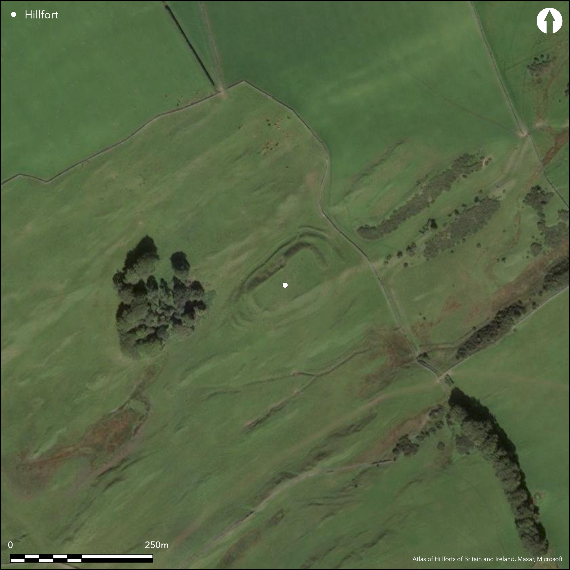
This fort occupies a rocky hillock on the SE flank of Bell Hill, and to some extent the elongated character of the hillock has determined the rectilinear plan of its defences. This is certainly how the RCAHMS investigators viewed the plan they drew up in 1949, with a unitary scheme of triple ramparts and ditches forming a belt from 23m deep along the NW and SE flanks, and up to 37m at the ends, where the outer defences swing round the hillock on a slightly wider arc. So much so, that more recent aerial photographs give the impression that the innermost enclosure, which measures internally some 70m from ENE to WSW by 29m transversely (0.21ha), may represent a reconfiguration of an earlier and more oval design. As such it conforms to a pattern of rectilinear settlements overlying earlier forts, though its rampart is a substantial feature, forming a mound 1.2m in height internally and dropping from 2.4m to 6.5m externally into the bottom of an accompanying ditch. The outer defences comprise two ramparts with external ditches, though in places these have been severely reduced by cultivation and the outermost ditch is visible only at the WSW end; on the NW flank the RCAHMS investigators speculated that the middle ditch had also been enlarged to facilitate the subsequent quarrying that has eaten back into the innermost rampart. There are entrances at the E and S angles, but the interior has been cultivated and is now featureless. A later pen or hut has been built across the middle rampart and the inner ditch on the W.
Citizen Science: ✗
Reliability of Data: Confirmed
Reliability of Interpretation: Confirmed
X: -311418 Y: 7469027 (EPSG: 3857)
Longitude: -2.7975179762394027 Latitude: 55.54835954984273 (EPSG:4326)
Country: Scotland
Current County or Unitary Authority: Scottish Borders
Historic County: Selkirkshire
Current Parish/Community/Council/Townland: Selkirk
None
| Extant | ✓ |
| Cropmark | ✗ |
| Likely Destroyed | ✗ |
None
| Woodland | ✗ |
| Commercial Forestry Plantation | ✗ |
| Parkland | ✗ |
| Pasture (Grazing) | ✓ |
| Arable | ✗ |
| Scrub/Bracken | ✗ |
| Bare Outcrop | ✗ |
| Heather/Moorland | ✓ |
| Heath | ✗ |
| Built-up | ✗ |
| Coastal Grassland | ✗ |
| Other | ✗ |
None
| Contour Fort | ✓ |
| Partial Contour Fort | ✗ |
| Promontory Fort | ✗ |
| Hillslope Fort | ✗ |
| Level Terrain Fort | ✗ |
| Marsh Fort | ✗ |
| Multiple Enclosure Fort | ✗ |
| Hilltop | ✗ |
| Coastal Promontory | ✗ |
| Inland Promontory | ✗ |
| Valley Bottom | ✗ |
| Knoll/Hillock/Outcrop | ✓ |
| Ridge | ✗ |
| Cliff/Plateau-edge/Scarp | ✗ |
| Hillslope | ✗ |
| Lowland | ✗ |
| Spur | ✗ |
Dominant Topographic Feature: Coastal headland.
| North | ✗ |
| Northeast | ✗ |
| East | ✗ |
| Southeast | ✗ |
| South | ✗ |
| Southwest | ✗ |
| West | ✗ |
| Northwest | ✗ |
| Level | ✓ |
Altitude: 275.0m
N/A
NoneIn the absence of excavation, there are neither stratified artefacts nor radiocarbon dates to provide a chronology for the defences.
Reliability: D - None
| Pre 1200BC | ✗ |
| 1200BC - 800BC | ✗ |
| 800BC - 400BC | ✗ |
| 400BC - AD50 | ✗ |
| AD50 - AD400 | ✗ |
| AD400 - AD 800 | ✗ |
| Post AD800 | ✗ |
| Unknown | ✓ |
| Pre Hillfort: | None |
| Post Hillfort: | Interior cultivated and quarrying along the innermost rampart on the NW |
Photographed from the air by CUCAP in 1966, by John Dent in 1991 and by RCAHMS Aerial Survey Programme in 1989 and 1994
| 1st Identified Map Depiction (1858): | Annotated Camp on the 1st edition OS 25-inch map (Roxburgh 1863, sheet 13.3) |
| Earthwork Survey (1894): | Sketch-plan and description by David Christison (1895, 113-14, fig 2) |
| Other (1939): | Scheduled |
| Earthwork Survey (1949): | Plan and description (RCAHMS 1957, 95-6, no.124, fig 116; RCAHMS SED 2/1-2) |
| Other (1961): | Visited by the OS |
Featureless
None
| None | ✓ |
| Spring | ✗ |
| Stream | ✗ |
| Pool | ✗ |
| Flush | ✗ |
| Well | ✗ |
| Other | ✗ |
None
| No Known Features | ✓ |
| Round Stone Structures | ✗ |
| Rectangular Stone Structures | ✗ |
| Curvilinear Platforms | ✗ |
| Other Roundhouse Evidence | ✗ |
| Pits | ✗ |
| Quarry Hollows | ✗ |
| Other | ✗ |
None
| No Known Excavation | ✓ |
| Pits | ✗ |
| Postholes | ✗ |
| Roundhouses | ✗ |
| Rectangular Structures | ✗ |
| Roads/Tracks | ✗ |
| Quarry Hollows | ✗ |
| Other | ✗ |
| Nothing Found | ✗ |
None
| No Known Geophysics | ✓ |
| Pits | ✗ |
| Roundhouses | ✗ |
| Rectangular Structures | ✗ |
| Roads/Tracks | ✗ |
| Quarry Hollows | ✗ |
| Other | ✗ |
| Nothing Found | ✗ |
None
| No Known Finds | ✓ |
| Pottery | ✗ |
| Metal | ✗ |
| Metalworking | ✗ |
| Human Bones | ✗ |
| Animal Bones | ✗ |
| Lithics | ✗ |
| Environmental | ✗ |
| Other | ✗ |
NO APPARENT FEATURES
| APs Not Checked | ✗ |
| None | ✓ |
| Roundhouses | ✗ |
| Rectangular Structures | ✗ |
| Pits | ✗ |
| Postholes | ✗ |
| Roads/Tracks | ✗ |
| Other | ✗ |
No details.
| 2: | None |
| 2: | None |
Guard Chambers: ✗
Chevaux de Frise: ✗
| 1. Simple Gap (East): | None |
| 2. Simple Gap (South west): | None |
Up to three ramparts and ditches, but probably representing several periods of construction.
| Area 1: | 0.21ha. |
| Total: | 0.21ha. |
Total Footprint Area: 0.97ha.
None
| ✓ | The ditch accompanying the innermost rampart appears to cut across the line of the middle rampart on the W |
| ✓ | None |
| NE Quadrant: | 3 |
| SE Quadrant: | 3 |
| SW Quadrant: | 3 |
| NW Quadrant: | 2 |
| Total: | 3 |
| Partial Univallate | ✗ |
| Univallate | ✗ |
| Partial Bivallate | ✓ |
| Bivallate | ✗ |
| Partial Multivallate | ✓ |
| Multivallate | ✗ |
| Unknown | ✗ |
| Partial Univallate | ✗ |
| Univallate | ✗ |
| Partial Bivallate | ✗ |
| Bivallate | ✓ |
| Partial Multivallate | ✗ |
| Multivallate | ✗ |
None
| None | ✗ |
| Earthen Bank | ✓ |
| Stone Wall | ✗ |
| Rubble | ✗ |
| Wall-walk | ✗ |
| Evidence of Timber | ✗ |
| Vitrification | ✗ |
| Other Burning | ✗ |
| Palisade | ✗ |
| Counter Scarp Bank | ✗ |
| Berm | ✗ |
| Unfinished | ✗ |
| Other | ✗ |
None
| None | ✗ |
| Earthen Bank | ✗ |
| Stone Wall | ✗ |
| Murus Duplex | ✗ |
| Timber-framed | ✗ |
| Timber-laced | ✗ |
| Vitrification | ✗ |
| Other Burning | ✗ |
| Palisade | ✗ |
| Counter Scarp Bank | ✗ |
| Berm | ✗ |
| Unfinished | ✗ |
| No Known Excavation | ✓ |
| Other | ✗ |
| ✗ | None |
| ✓ | None |
Number of Ditches: 3
| ✗ | None |
Christison, D (1895) 'The forts of Selkirk, the Gala Water, the Southern slopes of the Lammermoors, and the north of Roxburgh'. Proc Soc Antiq Scot 29 (1894-50), 108-79
RCAHMS (1957) The Royal Commission on the Ancient and Historical Monuments of Scotland. An inventory of the ancient and historical monuments of Selkirkshire with the fifteenth report of the Commission. HMSO: Edinburgh.
Atlas of Hillforts:
Wikidata:
This work is licensed under CC BY-SA 4.0![]()
![]()
![]() and should be cited as:
and should be cited as:
Lock, Gary and Ralston, Ian. 2024. Atlas of Hillforts of Britain and Ireland. Available at: https://hillforts.arch.ox.ac.uk
Document Version 1.1