Satellite Imagery
Satellite Imagery
HER: The West of Scotland Archaeology Service 1293 (None)
NMR: NM 84 SW 1 (23105)
SM: 239
NGR: NM 8372 4003
X: 183720 Y: 740030 (OSGB36)
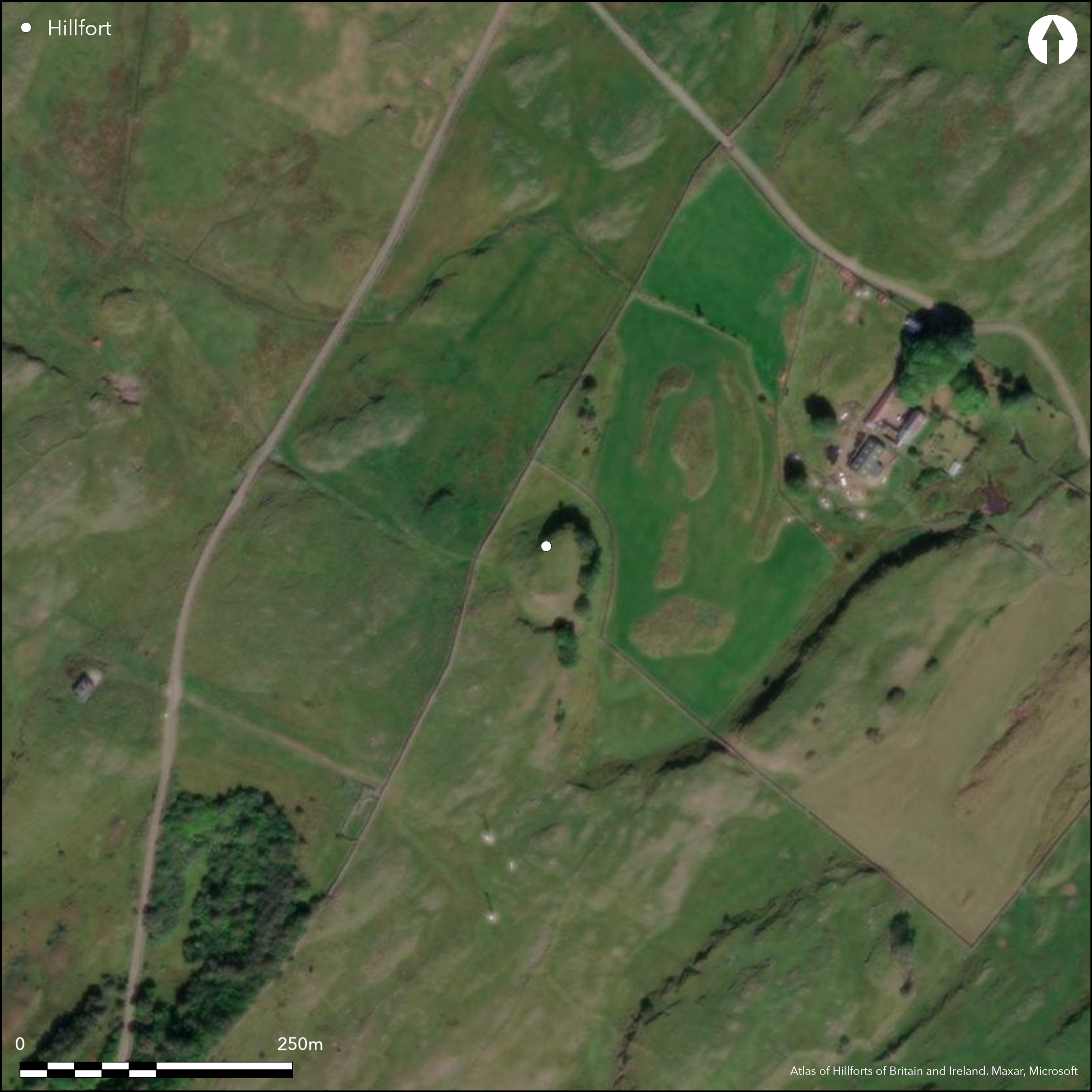
This small fortification is situated on the summit of a knoll that falls away steeply everywhere except the W, where it can be approached across relatively level ground. Oval on plan, it measures about 30m from N to S by 15m transversely (0.04ha) within a wall reduced on the S and W to a bank of rubble some 6m in thickness by up to 1.4m in height externally and 1m internally, and elsewhere apparently robbed entirely. The entrance is on the W, where an old dyke also mounts the flank of the knoll. The interior is featureless, but the OS noted the footings of two oval structures in the rubble of the wall to either side of the entrance.
Citizen Science: ✗
Reliability of Data: Confirmed
Reliability of Interpretation: Confirmed
X: -614034 Y: 7659116 (EPSG: 3857)
Longitude: -5.515962790741621 Latitude: 56.502544800060335 (EPSG:4326)
Country: Scotland
Current County or Unitary Authority: Argyll & Bute
Historic County: Argyll
Current Parish/Community/Council/Townland: Lismore And Appin
None
| Extant | ✓ |
| Cropmark | ✗ |
| Likely Destroyed | ✗ |
None
| Woodland | ✗ |
| Commercial Forestry Plantation | ✗ |
| Parkland | ✗ |
| Pasture (Grazing) | ✓ |
| Arable | ✗ |
| Scrub/Bracken | ✗ |
| Bare Outcrop | ✗ |
| Heather/Moorland | ✓ |
| Heath | ✗ |
| Built-up | ✗ |
| Coastal Grassland | ✗ |
| Other | ✗ |
None
| Contour Fort | ✓ |
| Partial Contour Fort | ✗ |
| Promontory Fort | ✗ |
| Hillslope Fort | ✗ |
| Level Terrain Fort | ✗ |
| Marsh Fort | ✗ |
| Multiple Enclosure Fort | ✗ |
| Hilltop | ✗ |
| Coastal Promontory | ✗ |
| Inland Promontory | ✗ |
| Valley Bottom | ✗ |
| Knoll/Hillock/Outcrop | ✓ |
| Ridge | ✗ |
| Cliff/Plateau-edge/Scarp | ✗ |
| Hillslope | ✗ |
| Lowland | ✗ |
| Spur | ✗ |
Dominant Topographic Feature: None
| North | ✗ |
| Northeast | ✗ |
| East | ✗ |
| Southeast | ✗ |
| South | ✗ |
| Southwest | ✗ |
| West | ✗ |
| Northwest | ✗ |
| Level | ✓ |
Altitude: 55.0m
N/A
In the absence of excavation, there are neither stratified artefacts nor radiocarbon dates to provide a chronology for the defences.
Reliability: D - None
| Pre 1200BC | ✗ |
| 1200BC - 800BC | ✗ |
| 800BC - 400BC | ✗ |
| 400BC - AD50 | ✗ |
| AD50 - AD400 | ✗ |
| AD400 - AD 800 | ✗ |
| Post AD800 | ✗ |
| Unknown | ✓ |
| Pre Hillfort: | None |
| Post Hillfort: | Stone-robbing |
Photographed by Graham and Anna Ritchie in 1968, and from the air by RCAHMS Aerial Survey Programme in 1991
| 1st Identified Map Depiction (1871): | Annotated Fort on the 1st edition OS 25-inch map (Argyll and Bute 1875, sheet 72.14) |
| Earthwork Survey (1888): | Sketch-plan and description by David Christison (1888, 377-8, fig 4) |
| Earthwork Survey (1943): | Description and sketch-plan by Angus Graham and Gordon Childe for RCAHMS wartime Emergency Surveys (RCAHMS SC1456419) |
| Other (1956): | Scheduled |
| Earthwork Survey (1969): | Plan and description (RCAHMS 1975, 88, no.178; RCAHMS AGD 422/1-2) |
| Other (1971): | Surveyed at 1:2500 by the OS |
| Other (2013): | Re-Scheduled |
Featureless apart from two possible oval structures built in the rubble of the wall to either side of the entrance.
None
| None | ✓ |
| Spring | ✗ |
| Stream | ✗ |
| Pool | ✗ |
| Flush | ✗ |
| Well | ✗ |
| Other | ✗ |
Possible oval structures overlying the ruined wall
| No Known Features | ✗ |
| Round Stone Structures | ✗ |
| Rectangular Stone Structures | ✗ |
| Curvilinear Platforms | ✗ |
| Other Roundhouse Evidence | ✗ |
| Pits | ✗ |
| Quarry Hollows | ✗ |
| Other | ✓ |
None
| No Known Excavation | ✓ |
| Pits | ✗ |
| Postholes | ✗ |
| Roundhouses | ✗ |
| Rectangular Structures | ✗ |
| Roads/Tracks | ✗ |
| Quarry Hollows | ✗ |
| Other | ✗ |
| Nothing Found | ✗ |
None
| No Known Geophysics | ✓ |
| Pits | ✗ |
| Roundhouses | ✗ |
| Rectangular Structures | ✗ |
| Roads/Tracks | ✗ |
| Quarry Hollows | ✗ |
| Other | ✗ |
| Nothing Found | ✗ |
None
| No Known Finds | ✓ |
| Pottery | ✗ |
| Metal | ✗ |
| Metalworking | ✗ |
| Human Bones | ✗ |
| Animal Bones | ✗ |
| Lithics | ✗ |
| Environmental | ✗ |
| Other | ✗ |
NO APPARENT FEATURES
| APs Not Checked | ✗ |
| None | ✓ |
| Roundhouses | ✗ |
| Rectangular Structures | ✗ |
| Pits | ✗ |
| Postholes | ✗ |
| Roads/Tracks | ✗ |
| Other | ✗ |
See main summary
| 1: | Incomplete circuit |
| 2: | None |
Guard Chambers: ✗
Chevaux de Frise: ✗
| 1. Simple Gap (West): | None |
Single wall drawn around the summit
| Area 1: | 0.04ha. |
| Total: | 0.04ha. |
Total Footprint Area: Noneha.
None
| ✗ | None |
| ✓ | Most visitors are of the opinion that the wall has been robbed on the N and E |
| NE Quadrant: | 1 |
| SE Quadrant: | 1 |
| SW Quadrant: | 1 |
| NW Quadrant: | 1 |
| Total: | 1 |
| Partial Univallate | ✗ |
| Univallate | ✓ |
| Partial Bivallate | ✗ |
| Bivallate | ✗ |
| Partial Multivallate | ✗ |
| Multivallate | ✗ |
| Unknown | ✗ |
| Partial Univallate | ✗ |
| Univallate | ✗ |
| Partial Bivallate | ✗ |
| Bivallate | ✗ |
| Partial Multivallate | ✗ |
| Multivallate | ✗ |
None
| None | ✗ |
| Earthen Bank | ✗ |
| Stone Wall | ✗ |
| Rubble | ✓ |
| Wall-walk | ✗ |
| Evidence of Timber | ✗ |
| Vitrification | ✗ |
| Other Burning | ✗ |
| Palisade | ✗ |
| Counter Scarp Bank | ✗ |
| Berm | ✗ |
| Unfinished | ✗ |
| Other | ✗ |
None
| None | ✗ |
| Earthen Bank | ✗ |
| Stone Wall | ✗ |
| Murus Duplex | ✗ |
| Timber-framed | ✗ |
| Timber-laced | ✗ |
| Vitrification | ✗ |
| Other Burning | ✗ |
| Palisade | ✗ |
| Counter Scarp Bank | ✗ |
| Berm | ✗ |
| Unfinished | ✗ |
| No Known Excavation | ✓ |
| Other | ✗ |
| ✗ | None |
| ✗ | None |
Number of Ditches: None
| ✗ | None |
Christison, D (1889) The duns and forts of Lorne, Nether Lochaber, and the neighbourhood'. Proc Soc Antiq Scot 23 (1888-9), 368-432
RCAHMS (1975) The Royal Commission on the Ancient and Historical Monuments of Scotland. Argyll: an inventory of the ancient monuments: volume 2: Lorn. HMSO: Edinburgh
Atlas of Hillforts:
Wikidata:
This work is licensed under CC BY-SA 4.0![]()
![]()
![]() and should be cited as:
and should be cited as:
Lock, Gary and Ralston, Ian. 2024. Atlas of Hillforts of Britain and Ireland. Available at: https://hillforts.arch.ox.ac.uk
Document Version 1.1