Satellite Imagery
Satellite Imagery
HER: The West of Scotland Archaeology Service 1735 (None)
NMR: NN 11 SW 2 (23635)
SM: None
NGR: NN 1003 1013
X: 210030 Y: 710130 (OSGB36)
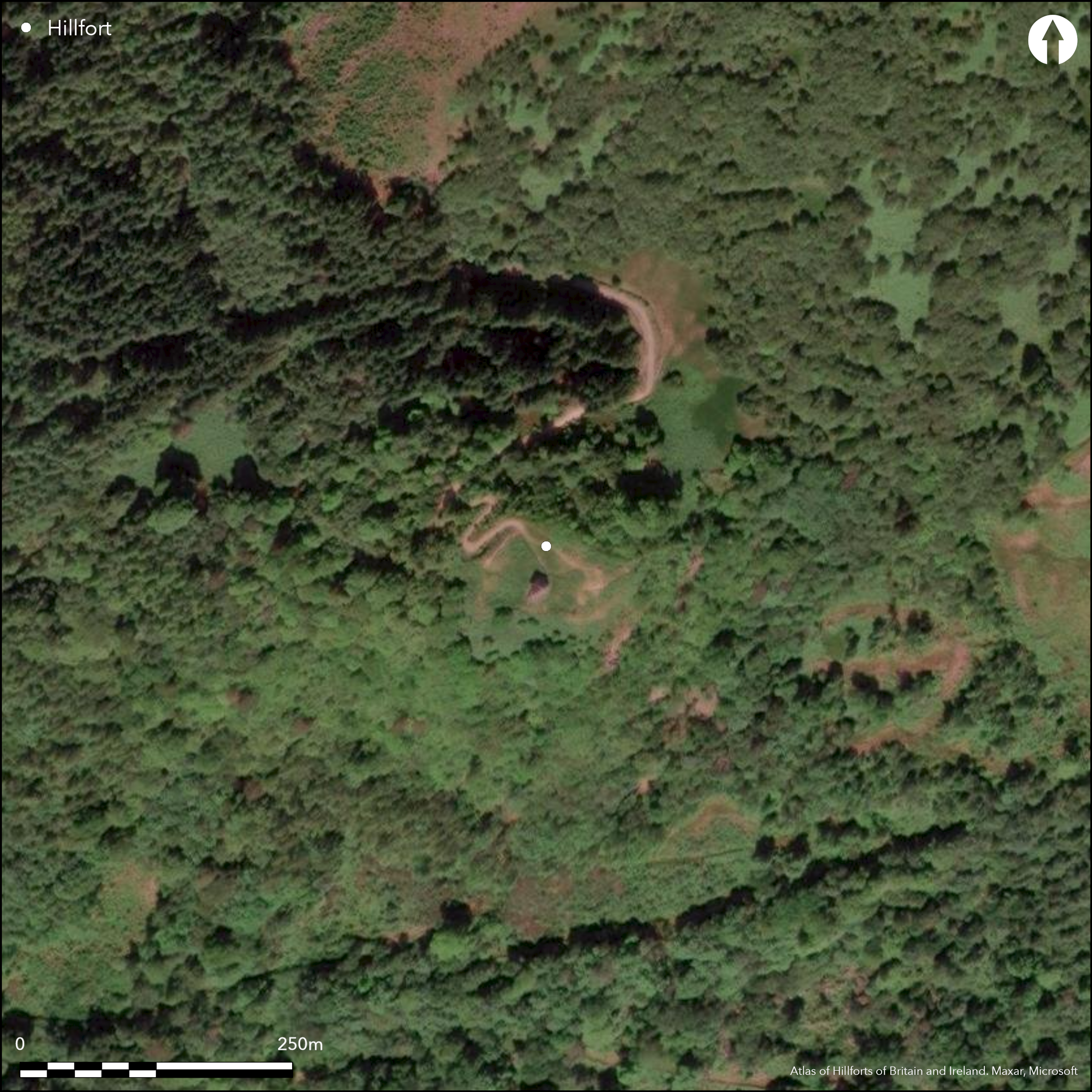
A fort is marked on the summit of Dun na Cuaiche on the 1st edition of the OS 25-inch map (Argyll and Bute 1874, sheet 133.6), surrounding a tower built in 1747-8 under the supervision of William Adam. It was included as a fort in the survey of mid-Argyll by Marion Campbell and Mary Sandeman (1962, 53), an identification confirmed by the OS surveyor who in 1973 revised the depiction at 1:2500, but omitted from the prehistoric monuments in the RCAHMS County Inventory for Mid-Argyll published in 1988, in which the various elements noted by the OS were considered to be part of the landscaping works around the tower that stands on the summit (RCAHMS 1992, 417-19, fig). Nevertheless, the enclosure is roughly triangular, measuring 65m from E to W by 40m transversely (0.2ha) within an earth and stone rampart which at the W end stands 2.6m in height internally; an entrance lies at the NW corner where the modern path approaches the summit. The ground falls away steeply from the summit on all sides except the N, and here an outer rampart of similar dimensions has been drawn across the slope over a distance of about 110m, broken only by an entrance with well-defined terminals. Several scarps and shallow sub-rectangular platforms are visible within the interior. While it is unlikely that the visible earthworks incorporate the remains of an earlier Iron Age or early medieval fortification, local tradition has it that this commanding summit was garrisoned in the mid 17th century (Campbell and Sandeman 1962, 53).
Citizen Science: ✗
Reliability of Data: Confirmed
Reliability of Interpretation: Irreconciled issues
X: -564117 Y: 7607475 (EPSG: 3857)
Longitude: -5.067546166264758 Latitude: 56.245658177980076 (EPSG:4326)
Country: Scotland
Current County or Unitary Authority: Argyll & Bute
Historic County: Argyll
Current Parish/Community/Council/Townland: Inverary
None
| Extant | ✓ |
| Cropmark | ✗ |
| Likely Destroyed | ✗ |
Grass and bracken covered clearing
| Woodland | ✓ |
| Commercial Forestry Plantation | ✗ |
| Parkland | ✗ |
| Pasture (Grazing) | ✗ |
| Arable | ✗ |
| Scrub/Bracken | ✓ |
| Bare Outcrop | ✗ |
| Heather/Moorland | ✓ |
| Heath | ✗ |
| Built-up | ✗ |
| Coastal Grassland | ✗ |
| Other | ✗ |
None
| Contour Fort | ✓ |
| Partial Contour Fort | ✗ |
| Promontory Fort | ✗ |
| Hillslope Fort | ✗ |
| Level Terrain Fort | ✗ |
| Marsh Fort | ✗ |
| Multiple Enclosure Fort | ✗ |
| Hilltop | ✓ |
| Coastal Promontory | ✗ |
| Inland Promontory | ✗ |
| Valley Bottom | ✗ |
| Knoll/Hillock/Outcrop | ✗ |
| Ridge | ✗ |
| Cliff/Plateau-edge/Scarp | ✗ |
| Hillslope | ✗ |
| Lowland | ✗ |
| Spur | ✗ |
Dominant Topographic Feature: None
| North | ✗ |
| Northeast | ✗ |
| East | ✗ |
| Southeast | ✗ |
| South | ✗ |
| Southwest | ✗ |
| West | ✗ |
| Northwest | ✗ |
| Level | ✓ |
Altitude: 245.0m
N/A
In the absence of excavation, there are neither stratified artefacts nor radiocarbon dates to provide a chronology for the defences, but they are likely to be post-medieval.
Reliability: D - None
| Pre 1200BC | ✗ |
| 1200BC - 800BC | ✗ |
| 800BC - 400BC | ✗ |
| 400BC - AD50 | ✗ |
| AD50 - AD400 | ✗ |
| AD400 - AD 800 | ✗ |
| Post AD800 | ✓ |
| Unknown | ✗ |
| Pre Hillfort: | None |
| Post Hillfort: | None |
None
| 1st Identified Written Reference (1843): | Noted (NSA, vii, Argyllshire, 25) |
| 1st Identified Map Depiction (1870): | Annotated Fort on the 1st edition OS 25-inch map (Argyll and Bute 1874, sheet 133.6) |
| Other (1963): | Description some time 1954-63 (Campbell and Sandeman 1962, 53) |
| Other (1973): | Survey revised at 1:2500 by the OS |
| Earthwork Survey (1988): | Plan and description (RCAHMS 1992, 417-19, fig; RCAHMS DC24645 & DC24864) |
Several sub-rectangular platforms
None
| None | ✓ |
| Spring | ✗ |
| Stream | ✗ |
| Pool | ✗ |
| Flush | ✗ |
| Well | ✗ |
| Other | ✗ |
None
| No Known Features | ✗ |
| Round Stone Structures | ✗ |
| Rectangular Stone Structures | ✓ |
| Curvilinear Platforms | ✗ |
| Other Roundhouse Evidence | ✗ |
| Pits | ✗ |
| Quarry Hollows | ✗ |
| Other | ✗ |
None
| No Known Excavation | ✓ |
| Pits | ✗ |
| Postholes | ✗ |
| Roundhouses | ✗ |
| Rectangular Structures | ✗ |
| Roads/Tracks | ✗ |
| Quarry Hollows | ✗ |
| Other | ✗ |
| Nothing Found | ✗ |
None
| No Known Geophysics | ✓ |
| Pits | ✗ |
| Roundhouses | ✗ |
| Rectangular Structures | ✗ |
| Roads/Tracks | ✗ |
| Quarry Hollows | ✗ |
| Other | ✗ |
| Nothing Found | ✗ |
None
| No Known Finds | ✓ |
| Pottery | ✗ |
| Metal | ✗ |
| Metalworking | ✗ |
| Human Bones | ✗ |
| Animal Bones | ✗ |
| Lithics | ✗ |
| Environmental | ✗ |
| Other | ✗ |
NO APPARENT FEATURES
| APs Not Checked | ✗ |
| None | ✓ |
| Roundhouses | ✗ |
| Rectangular Structures | ✗ |
| Pits | ✗ |
| Postholes | ✗ |
| Roads/Tracks | ✗ |
| Other | ✗ |
See main summary
| 2: | None |
| 2: | None |
Guard Chambers: ✗
Chevaux de Frise: ✗
| 1. Simple Gap (North west): | Through inner rampart |
| 2. Simple Gap (North): | Through outer rampart |
Single rampart round the summit with an outer one on the N
| Area 1: | 0.2ha. |
| Total: | 0.2ha. |
Total Footprint Area: Noneha.
None
| ✗ | None |
| ✓ | None |
| NE Quadrant: | 2 |
| SE Quadrant: | 1 |
| SW Quadrant: | 1 |
| NW Quadrant: | 1 |
| Total: | 2 |
| Partial Univallate | ✓ |
| Univallate | ✗ |
| Partial Bivallate | ✓ |
| Bivallate | ✗ |
| Partial Multivallate | ✗ |
| Multivallate | ✗ |
| Unknown | ✗ |
| Partial Univallate | ✗ |
| Univallate | ✗ |
| Partial Bivallate | ✗ |
| Bivallate | ✗ |
| Partial Multivallate | ✗ |
| Multivallate | ✗ |
None
| None | ✗ |
| Earthen Bank | ✓ |
| Stone Wall | ✗ |
| Rubble | ✗ |
| Wall-walk | ✗ |
| Evidence of Timber | ✗ |
| Vitrification | ✗ |
| Other Burning | ✗ |
| Palisade | ✗ |
| Counter Scarp Bank | ✗ |
| Berm | ✗ |
| Unfinished | ✗ |
| Other | ✗ |
None
| None | ✗ |
| Earthen Bank | ✗ |
| Stone Wall | ✗ |
| Murus Duplex | ✗ |
| Timber-framed | ✗ |
| Timber-laced | ✗ |
| Vitrification | ✗ |
| Other Burning | ✗ |
| Palisade | ✗ |
| Counter Scarp Bank | ✗ |
| Berm | ✗ |
| Unfinished | ✗ |
| No Known Excavation | ✓ |
| Other | ✗ |
| ✗ | None |
| ✗ | None |
Number of Ditches: None
| ✗ | None |
Campbell and Sandeman, M and M (1962) 'Mid Argyll: an archaeological survey', Proc Soc Antiq Scot 95 (1961-2), 1-125
Atlas of Hillforts:
Wikidata:
This work is licensed under CC BY-SA 4.0![]()
![]()
![]() and should be cited as:
and should be cited as:
Lock, Gary and Ralston, Ian. 2024. Atlas of Hillforts of Britain and Ireland. Available at: https://hillforts.arch.ox.ac.uk
Document Version 1.1