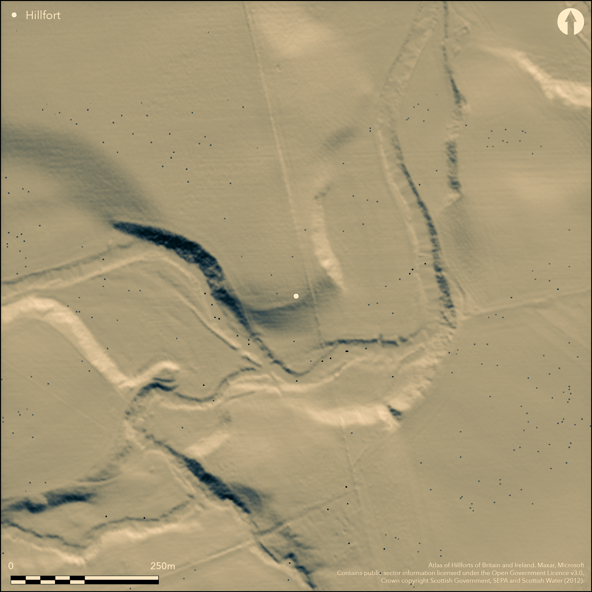
LiDAR 1m DTM Hillshade
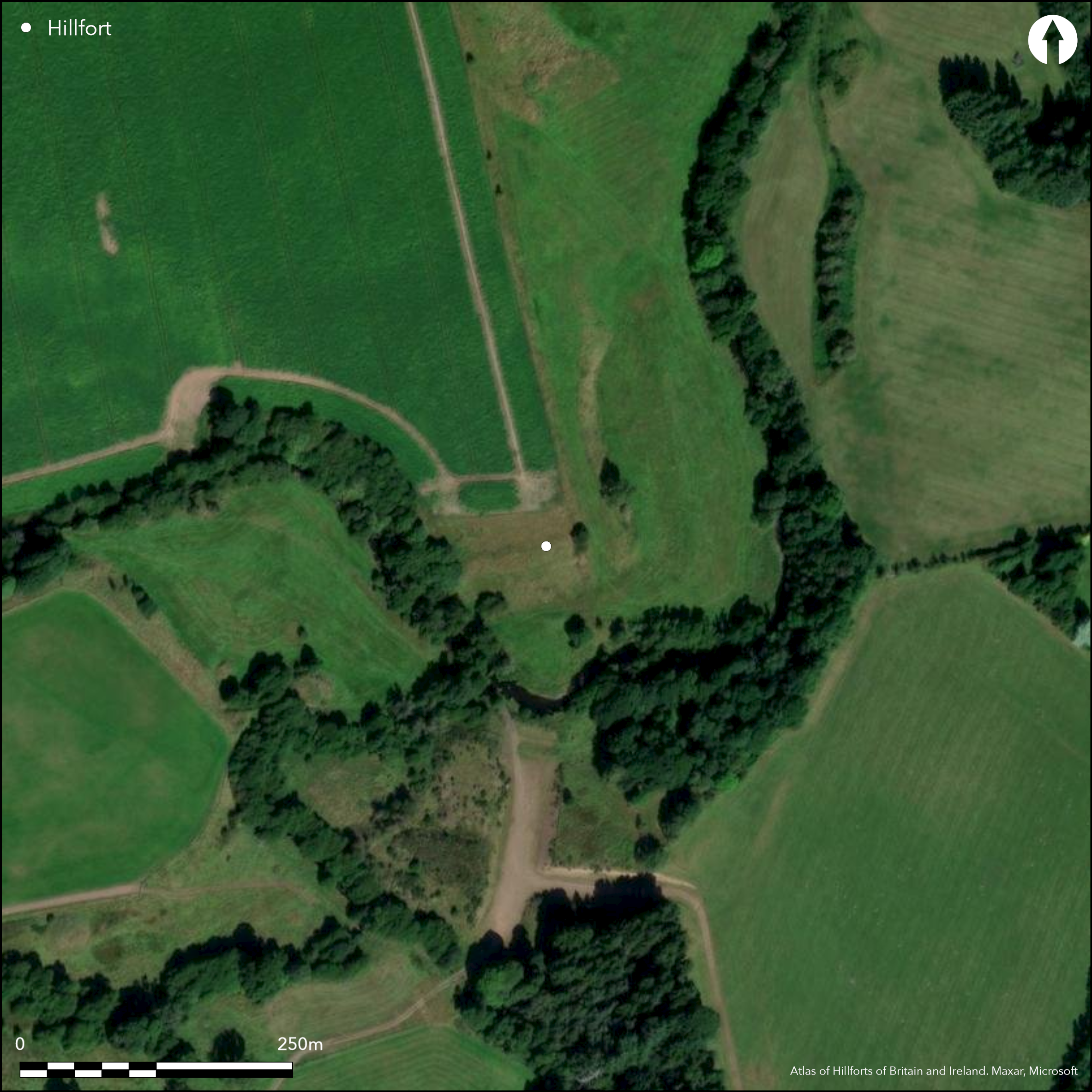
Satellite Imagery
LiDAR 1m DTM Hillshade
Satellite Imagery
Scroll left/right to view further images.
HER: Perth and Kinross Heritage Trust MPK1353 (None)
NMR: NN 91 NW 12 (26000)
SM: 7729
NGR: NN 9282 1581
X: 292820 Y: 715810 (OSGB36)
This fortification is situated at an angle in the edge of a broad terrace that forms a spur of higher ground projecting SE into a meander of the Machany Water. The escarpment on the E is steep and evidently river cut, but on the S it presents a much gentler profile. Whether the artificial defences were originally drawn across this gentler slope is unknown, but elsewhere on the W and NW cropmarks have revealed two roughly concentric ditches about 4m in breadth swinging in a slightly angular arc across the terrace to rest on the lip of the escarpment on the E. The interior thus defined measures at least 60m from N to S by up to 40m transversely (0.25ha), perhaps extending to some 0.2 ha when allowance is made for the presence of upcast ramparts. The entrance, which was partly excavated in 1987 (Barclay and Tolan 1990), is marked by a clearly-defined causeway on the W. The excavation demonstrated that the inner ditch was some 2m deep, and located a number of post-holes along the lips of both ditches, which were interpreted as the remains of associated fences. Trial excavation in the interior revealed a scatter of post-holes and an arc of the foundation trench of a timber round-house. Charcoal from a burnt oak post in the interior returned a radiocarbon date of 390-110 cal BC, but charcoal recovered from a rectangular stone floor in the upper fill of the inner ditch was dated to 1740-1320 cal BC. While the excavator opted to interpret this as evidence that the enclosure is Bronze Age, the taphonomy of this latter sample is unclear, and in the present state of knowledge the later Iron Age date is probably to be preferred for the use of the fortifications.
Citizen Science: ✗
Reliability of Data: Confirmed
Reliability of Interpretation: Confirmed
X: -415739 Y: 7622900 (EPSG: 3857)
Longitude: -3.734644197861544 Latitude: 56.32256850923812 (EPSG:4326)
Country: Scotland
Current County or Unitary Authority: Perth & Kinross
Historic County: Perthshire
Current Parish/Community/Council/Townland: Blackford
None
| Extant | ✗ |
| Cropmark | ✓ |
| Likely Destroyed | ✗ |
None
| Woodland | ✗ |
| Commercial Forestry Plantation | ✗ |
| Parkland | ✗ |
| Pasture (Grazing) | ✓ |
| Arable | ✓ |
| Scrub/Bracken | ✗ |
| Bare Outcrop | ✗ |
| Heather/Moorland | ✗ |
| Heath | ✗ |
| Built-up | ✗ |
| Coastal Grassland | ✗ |
| Other | ✗ |
None
| Contour Fort | ✗ |
| Partial Contour Fort | ✗ |
| Promontory Fort | ✗ |
| Hillslope Fort | ✗ |
| Level Terrain Fort | ✓ |
| Marsh Fort | ✗ |
| Multiple Enclosure Fort | ✗ |
| Hilltop | ✗ |
| Coastal Promontory | ✗ |
| Inland Promontory | ✗ |
| Valley Bottom | ✗ |
| Knoll/Hillock/Outcrop | ✗ |
| Ridge | ✗ |
| Cliff/Plateau-edge/Scarp | ✓ |
| Hillslope | ✗ |
| Lowland | ✗ |
| Spur | ✗ |
Dominant Topographic Feature: None
| North | ✗ |
| Northeast | ✗ |
| East | ✗ |
| Southeast | ✗ |
| South | ✗ |
| Southwest | ✗ |
| West | ✗ |
| Northwest | ✗ |
| Level | ✓ |
Altitude: 30.0m
N/A
Two radiocarbon dates of which one from the ditch fill is MBA and the other from the interior is LIA; the latter is to be preferred
Reliability: C - Low
| Pre 1200BC | ✓ |
| 1200BC - 800BC | ✗ |
| 800BC - 400BC | ✗ |
| 400BC - AD50 | ✓ |
| AD50 - AD400 | ✗ |
| AD400 - AD 800 | ✗ |
| Post AD800 | ✗ |
| Unknown | ✗ |
| Pre Hillfort: | None |
| Post Hillfort: | None |
| C14: | Two dates |
Also photographed on several occasions by RCAHMS aerial survey programme
| 1st Identified Written Reference (1960): | Discovered by CUCAP |
| 1st Identified Map Depiction (1967): | Surveyed at 1:2500 by the OS |
| Excavation (1987): | Excavation Barclay and Tolan (Barclay 1987; Barclay and Tolan 1990) |
| Other (2000): | Scheduled |
Featureless on cropmarks
None
| None | ✓ |
| Spring | ✗ |
| Stream | ✗ |
| Pool | ✗ |
| Flush | ✗ |
| Well | ✗ |
| Other | ✗ |
None
| No Known Features | ✓ |
| Round Stone Structures | ✗ |
| Rectangular Stone Structures | ✗ |
| Curvilinear Platforms | ✗ |
| Other Roundhouse Evidence | ✗ |
| Pits | ✗ |
| Quarry Hollows | ✗ |
| Other | ✗ |
None
| No Known Excavation | ✗ |
| Pits | ✓ |
| Postholes | ✓ |
| Roundhouses | ✓ |
| Rectangular Structures | ✗ |
| Roads/Tracks | ✗ |
| Quarry Hollows | ✗ |
| Other | ✗ |
| Nothing Found | ✗ |
None
| No Known Geophysics | ✓ |
| Pits | ✗ |
| Roundhouses | ✗ |
| Rectangular Structures | ✗ |
| Roads/Tracks | ✗ |
| Quarry Hollows | ✗ |
| Other | ✗ |
| Nothing Found | ✗ |
None
| No Known Finds | ✓ |
| Pottery | ✗ |
| Metal | ✗ |
| Metalworking | ✗ |
| Human Bones | ✗ |
| Animal Bones | ✗ |
| Lithics | ✗ |
| Environmental | ✗ |
| Other | ✗ |
NO APPARENT FEATURES
| APs Not Checked | ✗ |
| None | ✓ |
| Roundhouses | ✗ |
| Rectangular Structures | ✗ |
| Pits | ✗ |
| Postholes | ✗ |
| Roads/Tracks | ✗ |
| Other | ✗ |
See main summary
| 1: | Ploughed flat |
| 2: | None |
Guard Chambers: ✗
Chevaux de Frise: ✗
| 1. Simple Gap (West): | None |
Two ditches, presumably with upcast ramparts, effectively cutting off a promontory
| Area 1: | 0.2ha. |
| Total: | 0.2ha. |
Total Footprint Area: Noneha.
None
| ✗ | None |
| ✗ | None |
| NE Quadrant: | 0 |
| SE Quadrant: | 0 |
| SW Quadrant: | 2 |
| NW Quadrant: | 2 |
| Total: | 2 |
| Partial Univallate | ✗ |
| Univallate | ✗ |
| Partial Bivallate | ✓ |
| Bivallate | ✗ |
| Partial Multivallate | ✗ |
| Multivallate | ✗ |
| Unknown | ✗ |
| Partial Univallate | ✗ |
| Univallate | ✗ |
| Partial Bivallate | ✗ |
| Bivallate | ✗ |
| Partial Multivallate | ✗ |
| Multivallate | ✗ |
None
| None | ✓ |
| Earthen Bank | ✗ |
| Stone Wall | ✗ |
| Rubble | ✗ |
| Wall-walk | ✗ |
| Evidence of Timber | ✗ |
| Vitrification | ✗ |
| Other Burning | ✗ |
| Palisade | ✗ |
| Counter Scarp Bank | ✗ |
| Berm | ✗ |
| Unfinished | ✗ |
| Other | ✗ |
Twin ditches
| None | ✓ |
| Earthen Bank | ✗ |
| Stone Wall | ✗ |
| Murus Duplex | ✗ |
| Timber-framed | ✗ |
| Timber-laced | ✗ |
| Vitrification | ✗ |
| Other Burning | ✗ |
| Palisade | ✗ |
| Counter Scarp Bank | ✗ |
| Berm | ✗ |
| Unfinished | ✗ |
| No Known Excavation | ✗ |
| Other | ✓ |
| ✗ | None |
| ✓ | None |
Number of Ditches: 2
| ✗ | None |
Barclay and Tolan, G J and M (1990) 'Trial excavation of a terrace-edge enclosure at North Mains, Strathallan, Perthshire'. Proc Soc Antiq Scot 120 (1990), 45-53
Barclay, G J (1987) 'North Mains, Strathallan (Blackford parish) fort'. Disc Exc Scot (1987), 58-9
Atlas of Hillforts:
Wikidata:
This work is licensed under CC BY-SA 4.0![]()
![]()
![]() and should be cited as:
and should be cited as:
Lock, Gary and Ralston, Ian. 2024. Atlas of Hillforts of Britain and Ireland. Available at: https://hillforts.arch.ox.ac.uk
Document Version 1.1