Satellite Imagery
Satellite Imagery
HER: Perth and Kinross Heritage Trust MPK1397 (None)
NMR: NN 91 SE 1 (26046)
SM: 2976
NGR: NN 9976 1238
X: 299768 Y: 712383 (OSGB36)
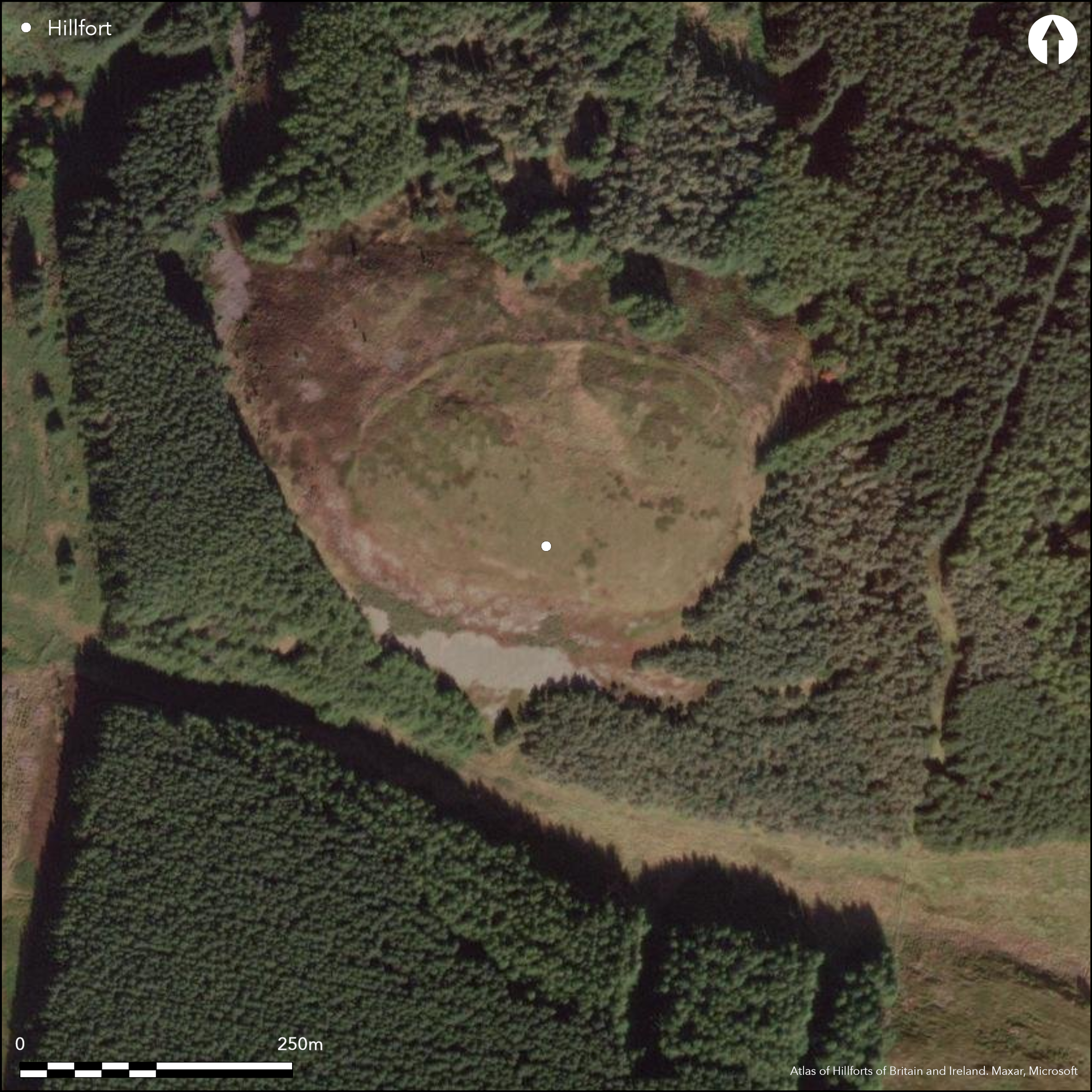
This fort is situated on the summit of Rossie Law, which is a steep-sided local summit on a spur dropping down the N face of the Ochils between Banekist Burn on the W and Scores Burn on the E. The summit of the hill rises some 50m above the saddle that separates it from the rest of the spur on the S, and there is also a precipitous crag on this flank. The defences comprise a single wall reduced to a bank a little over 4m in thickness, which extends around the shoulder of the hill above the crags to enclose an area measuring about 215m from E to W by 135m transversely (2.3ha). There is a single entrance on the SE, which in 1956 was the only place where RCAHMS investigators observed the remains of the wall faces; within the interior they also observed traces of several shallow scoops but hesitated from identifying any of them as house platforms. A geophysical survey was carried out in 2012 prior to excavations which sectioned the defences on the SE and sampled two places within the interior. The trench across the defences revealed that the wall had been roughly built with stone quarried from the interior; it overlay earlier midden deposits and outside its line there were two palisade trenches set some 5m apart. A circular hollow that retained water on the summit was shown to be a natural feature with a low bank on its lip.
Citizen Science: ✗
Reliability of Data: Confirmed
Reliability of Interpretation: Confirmed
X: -403093 Y: 7617029 (EPSG: 3857)
Longitude: -3.621045826094956 Latitude: 56.29331287377252 (EPSG:4326)
Country: Scotland
Current County or Unitary Authority: Perth & Kinross
Historic County: Perthshire
Current Parish/Community/Council/Townland: Dunning
None
| Extant | ✓ |
| Cropmark | ✗ |
| Likely Destroyed | ✗ |
Lies in a large clearing in commercial forestry
| Woodland | ✗ |
| Commercial Forestry Plantation | ✗ |
| Parkland | ✗ |
| Pasture (Grazing) | ✗ |
| Arable | ✗ |
| Scrub/Bracken | ✗ |
| Bare Outcrop | ✗ |
| Heather/Moorland | ✓ |
| Heath | ✗ |
| Built-up | ✗ |
| Coastal Grassland | ✗ |
| Other | ✗ |
None
| Contour Fort | ✓ |
| Partial Contour Fort | ✗ |
| Promontory Fort | ✗ |
| Hillslope Fort | ✗ |
| Level Terrain Fort | ✗ |
| Marsh Fort | ✗ |
| Multiple Enclosure Fort | ✗ |
| Hilltop | ✓ |
| Coastal Promontory | ✗ |
| Inland Promontory | ✗ |
| Valley Bottom | ✗ |
| Knoll/Hillock/Outcrop | ✗ |
| Ridge | ✗ |
| Cliff/Plateau-edge/Scarp | ✗ |
| Hillslope | ✗ |
| Lowland | ✗ |
| Spur | ✗ |
Dominant Topographic Feature: None
| North | ✗ |
| Northeast | ✗ |
| East | ✗ |
| Southeast | ✗ |
| South | ✗ |
| Southwest | ✗ |
| West | ✗ |
| Northwest | ✗ |
| Level | ✓ |
Altitude: 324.0m
N/A
Eight dates fall in the 1200-800 BC band, one 800-400 BC and five 400 BC - AD 50 (Information courtesy of Tessa Poller)
Reliability: B - Medium
| Pre 1200BC | ✗ |
| 1200BC - 800BC | ✓ |
| 800BC - 400BC | ✗ |
| 400BC - AD50 | ✗ |
| AD50 - AD400 | ✗ |
| AD400 - AD 800 | ✗ |
| Post AD800 | ✗ |
| Unknown | ✗ |
| Pre Hillfort: | None |
| Post Hillfort: | None |
| C14: | Fourteen dates |
None
| 1st Identified Map Depiction (1783): | Annotated Castle in ruins on James Stobie's map of The Counties of Perth and Clackmannan (1783) |
| Other (1860): | Annotated Fort on the 1st edition OS 25-inch map (Perth and Clackmannan 1866, sheet 118.4) |
| Earthwork Survey (1899): | Sketch-plan and description by David Christison (1899, 72-4, fig 31) |
| Other (1956): | Description for RCAHMS Survey of Marginal Lands (Feachem 1963, 146) |
| Other (1967): | Visited by the OS |
| Other (1970): | Scheduled |
| Geophysical Survey (2012): | Carried out by Tessa Poller as part of the SERF project by Glasgow University |
| Excavation (2012): | Dirested by Tessa Poller for the SERF project by Glasgow University |
Several hollows, but no clear house platforms, though two appear likely on oblique aerial photographs taken by RCAHMS
Unclear whether the hollow excavated was intended as a pond
| None | ✓ |
| Spring | ✗ |
| Stream | ✗ |
| Pool | ✗ |
| Flush | ✗ |
| Well | ✗ |
| Other | ✗ |
Several hollows observed within the interior
| No Known Features | ✗ |
| Round Stone Structures | ✗ |
| Rectangular Stone Structures | ✗ |
| Curvilinear Platforms | ✗ |
| Other Roundhouse Evidence | ✗ |
| Pits | ✗ |
| Quarry Hollows | ✗ |
| Other | ✓ |
Hollow retaining water
| No Known Excavation | ✗ |
| Pits | ✗ |
| Postholes | ✗ |
| Roundhouses | ✗ |
| Rectangular Structures | ✗ |
| Roads/Tracks | ✗ |
| Quarry Hollows | ✗ |
| Other | ✓ |
| Nothing Found | ✗ |
None
| No Known Geophysics | ✗ |
| Pits | ✗ |
| Roundhouses | ✗ |
| Rectangular Structures | ✗ |
| Roads/Tracks | ✗ |
| Quarry Hollows | ✗ |
| Other | ✗ |
| Nothing Found | ✓ |
None
| No Known Finds | ✓ |
| Pottery | ✗ |
| Metal | ✗ |
| Metalworking | ✗ |
| Human Bones | ✗ |
| Animal Bones | ✗ |
| Lithics | ✗ |
| Environmental | ✗ |
| Other | ✗ |
None
| APs Not Checked | ✗ |
| None | ✗ |
| Roundhouses | ✓ |
| Rectangular Structures | ✗ |
| Pits | ✗ |
| Postholes | ✗ |
| Roads/Tracks | ✗ |
| Other | ✗ |
See main summary
| 1: | None |
| 2: | None |
Guard Chambers: ✗
Chevaux de Frise: ✗
| 1. Simple Gap (South east): | None |
Single wall or rampart and two earlier palisades
| Area 1: | 2.3ha. |
| Total: | 2.3ha. |
Total Footprint Area: Noneha.
None
| ✓ | None |
| ✓ | None |
| NE Quadrant: | 1 |
| SE Quadrant: | 1 |
| SW Quadrant: | 1 |
| NW Quadrant: | 1 |
| Total: | 1 |
| Partial Univallate | ✗ |
| Univallate | ✓ |
| Partial Bivallate | ✗ |
| Bivallate | ✗ |
| Partial Multivallate | ✗ |
| Multivallate | ✗ |
| Unknown | ✗ |
| Partial Univallate | ✗ |
| Univallate | ✗ |
| Partial Bivallate | ✗ |
| Bivallate | ✗ |
| Partial Multivallate | ✗ |
| Multivallate | ✗ |
None
| None | ✗ |
| Earthen Bank | ✗ |
| Stone Wall | ✗ |
| Rubble | ✓ |
| Wall-walk | ✗ |
| Evidence of Timber | ✗ |
| Vitrification | ✗ |
| Other Burning | ✗ |
| Palisade | ✗ |
| Counter Scarp Bank | ✗ |
| Berm | ✗ |
| Unfinished | ✗ |
| Other | ✗ |
Two palisades
| None | ✗ |
| Earthen Bank | ✗ |
| Stone Wall | ✓ |
| Murus Duplex | ✗ |
| Timber-framed | ✗ |
| Timber-laced | ✗ |
| Vitrification | ✗ |
| Other Burning | ✗ |
| Palisade | ✓ |
| Counter Scarp Bank | ✗ |
| Berm | ✗ |
| Unfinished | ✗ |
| No Known Excavation | ✗ |
| Other | ✗ |
| ✗ | None |
| ✗ | None |
Number of Ditches: None
| ✗ | None |
Christison, D (1900) 'The forts, "camps", and other field-works of Perth, Forfar and Kincardine'. Proc Soc Antiq Scot 34 (1899-1900), 43-120
Feachem, R (1963) A guide to prehistoric Scotland. Batsford, London
Poller, T 2012 DES entry
Atlas of Hillforts:
Wikidata:
This work is licensed under CC BY-SA 4.0![]()
![]()
![]() and should be cited as:
and should be cited as:
Lock, Gary and Ralston, Ian. 2024. Atlas of Hillforts of Britain and Ireland. Available at: https://hillforts.arch.ox.ac.uk
Document Version 1.1