Satellite Imagery
Satellite Imagery
HER: Perth and Kinross Heritage Trust MPK1399 (None)
NMR: NN 91 SE 11 (26048)
SM: 4213
NGR: NN 9760 1271
X: 297604 Y: 712714 (OSGB36)
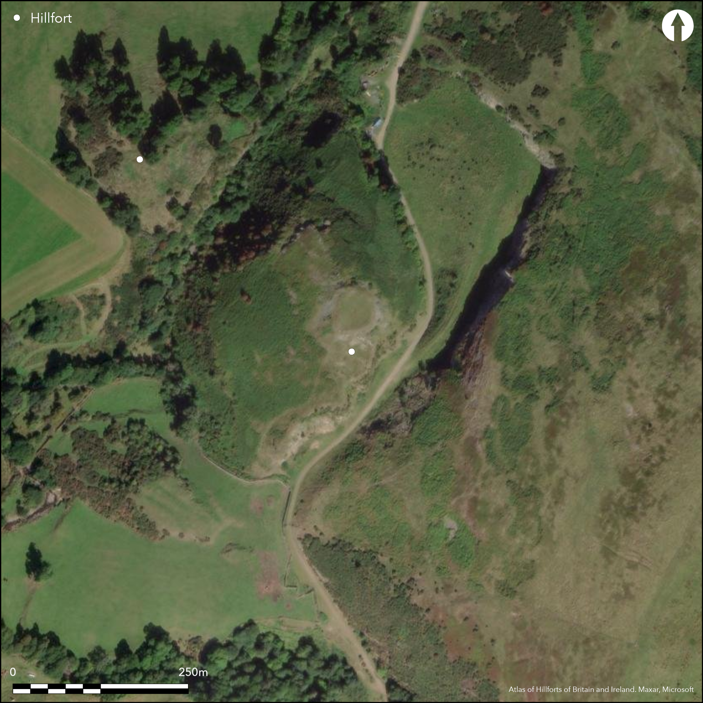
This fort is situated on a steep-sided and precipitous hillock between the foot of the NW flank of Craig Rossie and the gully of the Pairney Burn. The slopes here are particularly steep, while elsewhere on the NE and SE flanks, the latter now extensively modified by quarrying, the lower margin of the hillock falls away in low crags. On the NE and SE these crags seem to define the maximum extent of the interior, while two ramparts have been drawn across the foot of the more gentle and accessible flank on the SW. The outer seems to peter out after a short distance, but the inner can be traced to the lip of the steep slope dropping down to the Pairney Burn, where it probably turned NE along the lip of the gully, though little trace of it can be detected to the SW of a quarry cut into the spine of outcrops dropping down from the summit. To the NE of this quarry, however, it forms a terrace extending to the crags on the NE. Thus defined, the interior forms a rough parallelogram on plan, measuring about 175m from NE to SW by 115m transversely (2.22ha). On the SSW an entrance pierces both ramparts near the S apex, while a gap in the rampart about 5m short of the crags at the N apex probably marks the position of a second. Apart from an inner enclosure crowning the summit of the hillock, little can be seen within the interior on the SW flank, but there are at least four house platforms to the NE of the spine of outcrop dropping down from the summit. The summit enclosure measuring no more than 28m in diameter (0.06ha) within a wall that has collapsed down the slope into a massive scree of debris, which on the N quarter has cascaded into an external rock-cut ditch. Excavations in this summit enclosure recovered a Norse ring-headed pin from amongst the rubble, and showed that it had been constructed over the stump of a demolished broch measuring about 23m in diameter within a wall 5m in thickness; surviving floor levels were buried beneath burnt deposits containing a rich assemblage of artefacts dating from the 1st or 2nd centuries AD and including fragments of glass bangles and vessels, bronze objects and a stone bowl, while a bronze patera was also recovered from the overlying rubble (James 2011). The southern end of the fort defences were also sectioned and a fragment of a shale bangle was recovered. Previous excavations after quarrying in 1978 had destroyed the S terminal of these ramparts, exposed ten pits within the interior, most of which were capped by an area of paving and contained varying amounts of burnt animal bone; a fragment of a shale bangle was also found in one of them (Sherriff 1984).
Citizen Science: ✗
Reliability of Data: Confirmed
Reliability of Interpretation: Confirmed
X: -406998 Y: 7617532 (EPSG: 3857)
Longitude: -3.656122210941624 Latitude: 56.29582300991647 (EPSG:4326)
Country: Scotland
Current County or Unitary Authority: Perth & Kinross
Historic County: Perthshire
Current Parish/Community/Council/Townland: Auchterarder
None
| Extant | ✓ |
| Cropmark | ✗ |
| Likely Destroyed | ✗ |
None
| Woodland | ✗ |
| Commercial Forestry Plantation | ✗ |
| Parkland | ✗ |
| Pasture (Grazing) | ✓ |
| Arable | ✗ |
| Scrub/Bracken | ✓ |
| Bare Outcrop | ✗ |
| Heather/Moorland | ✓ |
| Heath | ✗ |
| Built-up | ✗ |
| Coastal Grassland | ✗ |
| Other | ✗ |
None
| Contour Fort | ✓ |
| Partial Contour Fort | ✗ |
| Promontory Fort | ✗ |
| Hillslope Fort | ✗ |
| Level Terrain Fort | ✗ |
| Marsh Fort | ✗ |
| Multiple Enclosure Fort | ✗ |
| Hilltop | ✓ |
| Coastal Promontory | ✗ |
| Inland Promontory | ✗ |
| Valley Bottom | ✗ |
| Knoll/Hillock/Outcrop | ✗ |
| Ridge | ✗ |
| Cliff/Plateau-edge/Scarp | ✗ |
| Hillslope | ✗ |
| Lowland | ✗ |
| Spur | ✗ |
Dominant Topographic Feature: None
| North | ✗ |
| Northeast | ✗ |
| East | ✗ |
| Southeast | ✗ |
| South | ✗ |
| Southwest | ✗ |
| West | ✗ |
| Northwest | ✗ |
| Level | ✓ |
Altitude: 139.0m
N/A
Roman goods recovered from the broch on the summit, and a Norse bronze ring-headed pin from the rubble of the wall that overlay it. In addition there are: six dates from a range of contexts fall 400 BC to AD 50; nine in AD 50-400, essentially relating to the occupation of the broch; and seven are post AD 800 (Information courtesy of Tessa Poller).
Reliability: B - Medium
| Pre 1200BC | ✗ |
| 1200BC - 800BC | ✗ |
| 800BC - 400BC | ✗ |
| 400BC - AD50 | ✗ |
| AD50 - AD400 | ✓ |
| AD400 - AD 800 | ✗ |
| Post AD800 | ✓ |
| Unknown | ✗ |
| Pre Hillfort: | None |
| Post Hillfort: | None |
| Artefactual: | Roman goods |
| C14: | Not yet published |
| Morphology/Earthwork/Typology: | Broch within the interior |
Photograhed by RCAHMS aerial survey programme in 1979 and 2005
| 1st Identified Map Depiction (1783): | Depicted by James Stobie on his map of the Counties of Perth and Clackmannan (1783) |
| 1st Identified Map Depiction (1967): | Description by the OS and surveyed at 1:2500 |
| Other (1971): | Description of the summit enclosure (Lye 1971) |
| Excavation (1978): | Rescue excavations by John Sherriff (1979; 1984) |
| Geophysical Survey (2011): | Tessa Poller for Glasgow University SERF project (Poller 2011) |
| Excavation (2011): | Excavations by Heather James for Glasgow University SERF project (2011) |
| Other (2015): | Visited by SH |
Apart from the broch beneath the summit enclosure, at least four house platforms can be seen in the NE flank. Others may be hidden in the bracken on the W, where there are several hollows in the slope
None
| None | ✓ |
| Spring | ✗ |
| Stream | ✗ |
| Pool | ✗ |
| Flush | ✗ |
| Well | ✗ |
| Other | ✗ |
Inner enclosure on the summit hiding the remains of a broch
| No Known Features | ✗ |
| Round Stone Structures | ✗ |
| Rectangular Stone Structures | ✗ |
| Curvilinear Platforms | ✓ |
| Other Roundhouse Evidence | ✗ |
| Pits | ✗ |
| Quarry Hollows | ✗ |
| Other | ✓ |
Broch
| No Known Excavation | ✗ |
| Pits | ✓ |
| Postholes | ✗ |
| Roundhouses | ✗ |
| Rectangular Structures | ✗ |
| Roads/Tracks | ✗ |
| Quarry Hollows | ✗ |
| Other | ✓ |
| Nothing Found | ✗ |
None
| No Known Geophysics | ✗ |
| Pits | ✗ |
| Roundhouses | ✗ |
| Rectangular Structures | ✗ |
| Roads/Tracks | ✗ |
| Quarry Hollows | ✗ |
| Other | ✗ |
| Nothing Found | ✓ |
Two small scraps of pottery were found in 1978, along with a fragment of shale bangle; a fragment of another shale bangle was found in 2011.
| No Known Finds | ✗ |
| Pottery | ✓ |
| Metal | ✗ |
| Metalworking | ✗ |
| Human Bones | ✗ |
| Animal Bones | ✗ |
| Lithics | ✓ |
| Environmental | ✗ |
| Other | ✗ |
NO APPARENT FEATURES
| APs Not Checked | ✗ |
| None | ✓ |
| Roundhouses | ✗ |
| Rectangular Structures | ✗ |
| Pits | ✗ |
| Postholes | ✗ |
| Roads/Tracks | ✗ |
| Other | ✗ |
See main summary
| 0: | Incomplete circuit |
| 2: | None |
Guard Chambers: ✗
Chevaux de Frise: ✗
| 1. Simple Gap (North): | None |
| 2. Simple Gap (South west): | None |
Two ramparts on one side and a broch beneath a later summit enclosure
| Area 1: | 0.06ha. |
| Area 2: | 2.22ha. |
| Total: | 2.22ha. |
Total Footprint Area: 2.35ha.
None
| ✓ | None |
| ✗ | This discounts the post broch summit enclosure |
| NE Quadrant: | 0 |
| SE Quadrant: | 0 |
| SW Quadrant: | 2 |
| NW Quadrant: | 1 |
| Total: | 2 |
| Partial Univallate | ✓ |
| Univallate | ✗ |
| Partial Bivallate | ✓ |
| Bivallate | ✗ |
| Partial Multivallate | ✗ |
| Multivallate | ✗ |
| Unknown | ✗ |
| Partial Univallate | ✗ |
| Univallate | ✗ |
| Partial Bivallate | ✗ |
| Bivallate | ✗ |
| Partial Multivallate | ✗ |
| Multivallate | ✗ |
None
| None | ✗ |
| Earthen Bank | ✗ |
| Stone Wall | ✗ |
| Rubble | ✓ |
| Wall-walk | ✗ |
| Evidence of Timber | ✗ |
| Vitrification | ✗ |
| Other Burning | ✗ |
| Palisade | ✗ |
| Counter Scarp Bank | ✗ |
| Berm | ✗ |
| Unfinished | ✗ |
| Other | ✗ |
None
| None | ✗ |
| Earthen Bank | ✗ |
| Stone Wall | ✓ |
| Murus Duplex | ✗ |
| Timber-framed | ✗ |
| Timber-laced | ✗ |
| Vitrification | ✗ |
| Other Burning | ✗ |
| Palisade | ✗ |
| Counter Scarp Bank | ✗ |
| Berm | ✗ |
| Unfinished | ✗ |
| No Known Excavation | ✗ |
| Other | ✗ |
| ✗ | None |
| ✓ | There is a ditch associated with the inner enclosure |
Number of Ditches: 1
| ✗ | None |
James, H (2011) 'Castle Craig: SERF, Perth and Kinross (Auchterarder parish), excavation'. Disc Exc Scot, New Ser, 12 (2011), 144-145
Lye, D M (1971) 'Auchterarder, Pairney Farm, fortification'. Disc Exc Scot (1971), 33
Poller, T (2011) 'Ben Effrey and Castle Craig: The Strathearn Environs and Royal Forteviot Project (SERF), Perth and Kinross (Auchterarder parish), geophysical survey'. Disc Exc Scot, New Ser, 12 (2011), 143-144
Sherriff, J R (1979) 'Castle Craig Fort (Auchterarder parish) pits, ramparts'. Disc Exc Scot (1979), 44-5
Sherriff, J R (1984) 'Excavations at Castle Craig, Auchterarder, 1978'. Proc Soc Antiq Scot 114 (1984), 574-7
Atlas of Hillforts:
Wikidata:
This work is licensed under CC BY-SA 4.0![]()
![]()
![]() and should be cited as:
and should be cited as:
Lock, Gary and Ralston, Ian. 2024. Atlas of Hillforts of Britain and Ireland. Available at: https://hillforts.arch.ox.ac.uk
Document Version 1.1