Satellite Imagery
Satellite Imagery
HER: Perth and Kinross Heritage Trust MPK1560 (None)
NMR: NN 93 SW 1 (26219)
SM: 2286
NGR: NN 9077 3032
X: 290770 Y: 730320 (OSGB36)
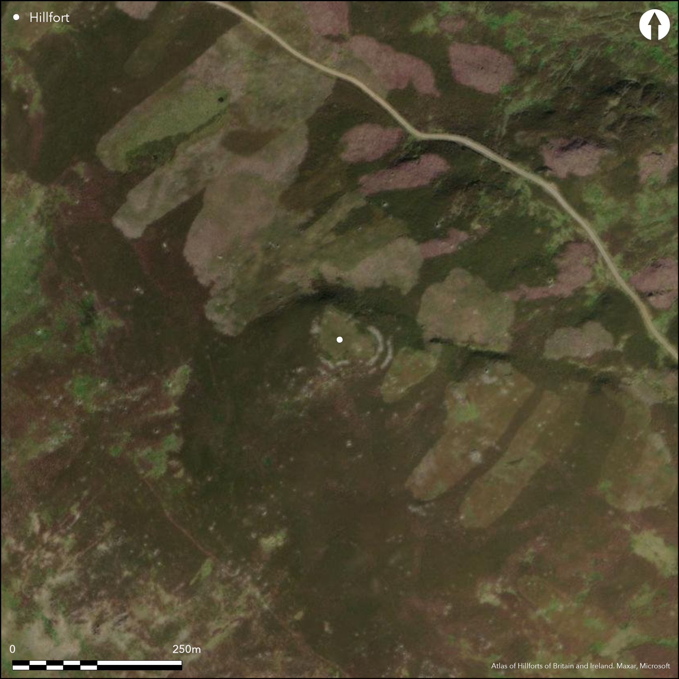
This fort occupies the first summit on the NE side of the mouth of the Sma' Glen. Roughly oval on plan, it measures about 50m from NW to SE by 30m transversely (0.14ha) within two walls set about 7m apart. The inner, which is largely reduced to a band of rubble up to 5m in breadth but with a few outer facing-stones visible on the E and S, is continuous, but the outer can only be traced around the SE and SW. In 1956 RCAHMS investigators noted an entrance approached by a hollowed track on the NW and a possible second on the NE, though in 1970 the OS could see neither. In addition to these defences, traces of an outer enclosure were noted by the RCAHMS investigators cutting across the spur some 25m to the E and returning on the S; evidently not defensive, it comprised a ditch some 1.5m in breadth, probably with an external bank, and broken by numerous causeways, leading to the suggestion that it might be the remains of an unfinished work of some kind, though there is no other evidence to suggest that this is an unfinished fort. On this side they also noted a scooped rectangular floor outside the outer wall.
Citizen Science: ✗
Reliability of Data: Confirmed
Reliability of Interpretation: Confirmed
X: -420100 Y: 7649008 (EPSG: 3857)
Longitude: -3.773822099852664 Latitude: 56.452399985028556 (EPSG:4326)
Country: Scotland
Current County or Unitary Authority: Perth & Kinross
Historic County: Perthshire
Current Parish/Community/Council/Townland: Fowlis Wester
None
| Extant | ✓ |
| Cropmark | ✗ |
| Likely Destroyed | ✗ |
None
| Woodland | ✗ |
| Commercial Forestry Plantation | ✗ |
| Parkland | ✗ |
| Pasture (Grazing) | ✗ |
| Arable | ✗ |
| Scrub/Bracken | ✗ |
| Bare Outcrop | ✗ |
| Heather/Moorland | ✓ |
| Heath | ✗ |
| Built-up | ✗ |
| Coastal Grassland | ✗ |
| Other | ✗ |
None
| Contour Fort | ✓ |
| Partial Contour Fort | ✗ |
| Promontory Fort | ✗ |
| Hillslope Fort | ✗ |
| Level Terrain Fort | ✗ |
| Marsh Fort | ✗ |
| Multiple Enclosure Fort | ✗ |
| Hilltop | ✓ |
| Coastal Promontory | ✗ |
| Inland Promontory | ✗ |
| Valley Bottom | ✗ |
| Knoll/Hillock/Outcrop | ✗ |
| Ridge | ✗ |
| Cliff/Plateau-edge/Scarp | ✗ |
| Hillslope | ✗ |
| Lowland | ✗ |
| Spur | ✗ |
Dominant Topographic Feature: None
| North | ✗ |
| Northeast | ✗ |
| East | ✗ |
| Southeast | ✗ |
| South | ✗ |
| Southwest | ✗ |
| West | ✗ |
| Northwest | ✗ |
| Level | ✓ |
Altitude: 465.0m
N/A
In the absence of excavation, there are neither stratified artefacts nor radiocarbon dates to provide a chronology for the defences.
Reliability: D - None
| Pre 1200BC | ✗ |
| 1200BC - 800BC | ✗ |
| 800BC - 400BC | ✗ |
| 400BC - AD50 | ✗ |
| AD50 - AD400 | ✗ |
| AD400 - AD 800 | ✗ |
| Post AD800 | ✗ |
| Unknown | ✓ |
| Pre Hillfort: | None |
| Post Hillfort: | probable stone robbing |
Named on General William Roy's Military Survey (1747-55), but not depicted
| 1st Identified Map Depiction (1783): | Annotated Castle in ruins on James Stobie's map of The Counties of Perth and Clackmannan (1783) |
| 1st Identified Written Reference (1795): | Description (Stat Acct xv, 1795, 156-7) |
| Other (1863): | Annotated Fort on the 1st edition OS 6-inch map (Perth and Clackmannan 1867, sheet 83) |
| Other (1899): | Description by David Christison (1900, 67-9) |
| Other (1956): | Sketch-plan and description for RCAHMS Survey of Marginal Lands (Feachem 1963, 146) |
| Other (1963): | Scheduled |
| Other (1970): | Surveyed at 1:10,000 by the OS |
| Other (1975): | Surveyed at 1:10,000 by the OS |
Featureless in most records, though on a visit in 2015 Tessa Poller noted three possible house sites on the S and E.
None
| None | ✓ |
| Spring | ✗ |
| Stream | ✗ |
| Pool | ✗ |
| Flush | ✗ |
| Well | ✗ |
| Other | ✗ |
on a visit in 2015 Tessa Poller noted three possible house sites on the S and E
| No Known Features | ✗ |
| Round Stone Structures | ✗ |
| Rectangular Stone Structures | ✗ |
| Curvilinear Platforms | ✗ |
| Other Roundhouse Evidence | ✗ |
| Pits | ✗ |
| Quarry Hollows | ✗ |
| Other | ✓ |
None
| No Known Excavation | ✓ |
| Pits | ✗ |
| Postholes | ✗ |
| Roundhouses | ✗ |
| Rectangular Structures | ✗ |
| Roads/Tracks | ✗ |
| Quarry Hollows | ✗ |
| Other | ✗ |
| Nothing Found | ✗ |
None
| No Known Geophysics | ✓ |
| Pits | ✗ |
| Roundhouses | ✗ |
| Rectangular Structures | ✗ |
| Roads/Tracks | ✗ |
| Quarry Hollows | ✗ |
| Other | ✗ |
| Nothing Found | ✗ |
None
| No Known Finds | ✓ |
| Pottery | ✗ |
| Metal | ✗ |
| Metalworking | ✗ |
| Human Bones | ✗ |
| Animal Bones | ✗ |
| Lithics | ✗ |
| Environmental | ✗ |
| Other | ✗ |
NO APPARENT FEATURES
| APs Not Checked | ✗ |
| None | ✓ |
| Roundhouses | ✗ |
| Rectangular Structures | ✗ |
| Pits | ✗ |
| Postholes | ✗ |
| Roads/Tracks | ✗ |
| Other | ✗ |
See main summary
| 2: | None |
| 2: | noted by RCAHMS, but neither observed by OS |
Guard Chambers: ✗
Chevaux de Frise: ✗
| 1. Simple Gap (North west): | None |
| 2. Simple Gap (North east): | None |
Two walls
| Area 1: | 0.14ha. |
| Total: | 0.14ha. |
Total Footprint Area: Noneha.
None
| ✗ | None |
| ✓ | None |
| NE Quadrant: | 1 |
| SE Quadrant: | 2 |
| SW Quadrant: | 2 |
| NW Quadrant: | 1 |
| Total: | 2 |
| Partial Univallate | ✓ |
| Univallate | ✗ |
| Partial Bivallate | ✓ |
| Bivallate | ✗ |
| Partial Multivallate | ✗ |
| Multivallate | ✗ |
| Unknown | ✗ |
| Partial Univallate | ✗ |
| Univallate | ✗ |
| Partial Bivallate | ✗ |
| Bivallate | ✗ |
| Partial Multivallate | ✗ |
| Multivallate | ✗ |
RCAHMS investigators suggest the outer enclosure is unfinished
| None | ✗ |
| Earthen Bank | ✗ |
| Stone Wall | ✓ |
| Rubble | ✗ |
| Wall-walk | ✗ |
| Evidence of Timber | ✗ |
| Vitrification | ✗ |
| Other Burning | ✗ |
| Palisade | ✗ |
| Counter Scarp Bank | ✗ |
| Berm | ✗ |
| Unfinished | ✓ |
| Other | ✗ |
None
| None | ✗ |
| Earthen Bank | ✗ |
| Stone Wall | ✗ |
| Murus Duplex | ✗ |
| Timber-framed | ✗ |
| Timber-laced | ✗ |
| Vitrification | ✗ |
| Other Burning | ✗ |
| Palisade | ✗ |
| Counter Scarp Bank | ✗ |
| Berm | ✗ |
| Unfinished | ✗ |
| No Known Excavation | ✓ |
| Other | ✗ |
| ✗ | None |
| ✗ | An outer enclosure on one side has a ditch |
Number of Ditches: None
| ✓ | An outer enclosure was identified by RCAHMS investigators in 1956, though its accompanying ditch is very slight an does not appear to be defensive |
Christison, D (1900) 'The forts, "camps", and other field-works of Perth, Forfar and Kincardine'. Proc Soc Antiq Scot 34 (1899-1900), 43-120
Feachem, R W (1963) Guide to Prehistoric Scotland. Batsford: London
Forsyth, R (1805-8) The beauties of Scotland: containing a clear and full account of the agriculture, commerce. mines and manufactures of the population, cities, towns, villages &c of each county, 5v. Edinburgh
Hunter and Jamieson, J and H M (eds) (1896) Chronicles of Strathearn. Crieff
Macara, D (1896) Macara's guide to Crieff, Comrie, St Fillans and Upper Strathearn including excursions to every point and place of interest in the district. Edinburgh
Marshall, W (1881) Historic scenes in Perthshire. Edinburgh
Perth Guide (1820) Guide to the city and county of Perth containing a topographical and statistical account of the city, with occasional notices of its antiquities, a description of the environs and of the picturesque scenery in the county in the form of tours, 'Fourth Edition, enlarged, and embellished with fourteen maps, plans and engravings'. Perth
Stat Acct (date) Statistical Account of Scotland: Drawn up from the Communications of the Ministers of the Different Parishes (Sinclair, J ed), 1791-99
Atlas of Hillforts:
Wikidata:
This work is licensed under CC BY-SA 4.0![]()
![]()
![]() and should be cited as:
and should be cited as:
Lock, Gary and Ralston, Ian. 2024. Atlas of Hillforts of Britain and Ireland. Available at: https://hillforts.arch.ox.ac.uk
Document Version 1.1