Satellite Imagery
Satellite Imagery
HER: Perth and Kinross Heritage Trust MPK1405 (None)
NMR: NN 91 SE 17 (26054)
SM: 9373
NGR: NN 9744 1287
X: 297440 Y: 712870 (OSGB36)
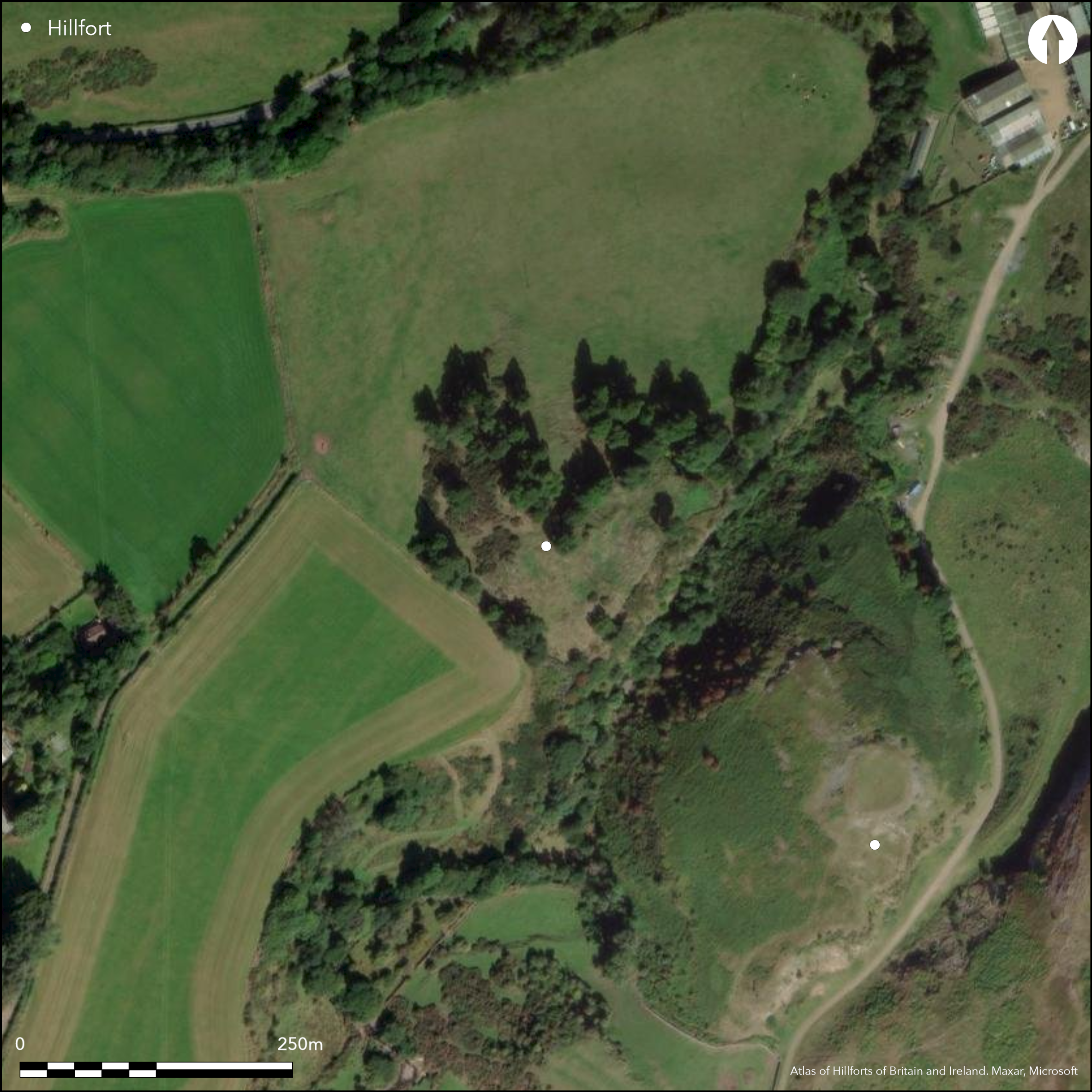
The remains of a small fortification are situated on the summit of Kay Craig, a knoll forming the NW side of a precipitous gorge opposite Castle Craig (Atlas No.2650). The summit of the knoll is crowned by a substantial circular stone structure measuring about 11m in internal diameter and 20m overall, but this lies within a larger enclosure that backs onto the escarpment falling away into the gorge on the SE. Roughly oval on plan, this latter measures some 65m from NE to SW by up to 30m transversely (0.15ha) within a single wall, which can be traced round the shoulder of the knoll on the N and SW, and spans a shallow gully on the NW; apparently earth-cored with stone faces, the wall measures about 3m in thickness and up to 1m in height. A gap on the NW is probably a result of quarrying activity on the knoll, which is clearly in evidence on the N flank of the summit, but a second gap on the SW, where the wall terminates on the outcrops short of the edge of the escarpment, possibly marks the original entrance into the interior. There is also a line of boulders on the leading edge of a lower terrace below the wall on the SW, though whether part of the defences or a later feature is unknown.
Citizen Science: ✗
Reliability of Data: Confirmed
Reliability of Interpretation: Confirmed
X: -407299 Y: 7617806 (EPSG: 3857)
Longitude: -3.658831616076796 Latitude: 56.297188538789065 (EPSG:4326)
Country: Scotland
Current County or Unitary Authority: Perth & Kinross
Historic County: Perthshire
Current Parish/Community/Council/Townland: Auchterarder
None
| Extant | ✓ |
| Cropmark | ✗ |
| Likely Destroyed | ✗ |
None
| Woodland | ✓ |
| Commercial Forestry Plantation | ✗ |
| Parkland | ✗ |
| Pasture (Grazing) | ✗ |
| Arable | ✗ |
| Scrub/Bracken | ✓ |
| Bare Outcrop | ✗ |
| Heather/Moorland | ✗ |
| Heath | ✗ |
| Built-up | ✗ |
| Coastal Grassland | ✗ |
| Other | ✗ |
None
| Contour Fort | ✓ |
| Partial Contour Fort | ✗ |
| Promontory Fort | ✗ |
| Hillslope Fort | ✗ |
| Level Terrain Fort | ✗ |
| Marsh Fort | ✗ |
| Multiple Enclosure Fort | ✗ |
| Hilltop | ✗ |
| Coastal Promontory | ✗ |
| Inland Promontory | ✗ |
| Valley Bottom | ✗ |
| Knoll/Hillock/Outcrop | ✓ |
| Ridge | ✗ |
| Cliff/Plateau-edge/Scarp | ✓ |
| Hillslope | ✗ |
| Lowland | ✗ |
| Spur | ✗ |
Dominant Topographic Feature: None
| North | ✗ |
| Northeast | ✗ |
| East | ✗ |
| Southeast | ✗ |
| South | ✗ |
| Southwest | ✗ |
| West | ✗ |
| Northwest | ✗ |
| Level | ✓ |
Altitude: 105.0m
N/A
Three dates from the fort wall lie between 800-400 BC, though another from a later phase is AD 50-400, tying in with another five from the structure on the summit; a fragment of Roman glass was also found; and there was later occupation in the medieval period
Reliability: D - None
| Pre 1200BC | ✗ |
| 1200BC - 800BC | ✗ |
| 800BC - 400BC | ✓ |
| 400BC - AD50 | ✗ |
| AD50 - AD400 | ✓ |
| AD400 - AD 800 | ✗ |
| Post AD800 | ✗ |
| Unknown | ✗ |
| Pre Hillfort: | None |
| Post Hillfort: | None |
| Artefactual: | None |
| C14: | Nine dates |
Hidden beneath woodland in the mid 19th century, it does not appear on early editions of the OS 6-inch and 25-inch maps
| 1st Identified Map Depiction (1783): | Annotated Castle in ruins on James Stobie's map of The Counties of Perth and Clackmannan (1783) |
| Other (1979): | Description and rediscovery (Sherriff 1979) |
| Other (2002): | Scheduled |
| Earthwork Survey (2014): | By RCAHMS for Glasgow University SERF project (RCAHMS DC57659; GV005443) |
| Excavation (2014): | Evaluation directed by Tessa Poller for Glasgow University SERF project |
Featureless apart the circular stone structure occupying the summit of the knoll
None
| None | ✓ |
| Spring | ✗ |
| Stream | ✗ |
| Pool | ✗ |
| Flush | ✗ |
| Well | ✗ |
| Other | ✗ |
Substantial circular stone building
| No Known Features | ✗ |
| Round Stone Structures | ✗ |
| Rectangular Stone Structures | ✗ |
| Curvilinear Platforms | ✗ |
| Other Roundhouse Evidence | ✗ |
| Pits | ✗ |
| Quarry Hollows | ✗ |
| Other | ✓ |
Substantial circular stone building
| No Known Excavation | ✗ |
| Pits | ✗ |
| Postholes | ✗ |
| Roundhouses | ✓ |
| Rectangular Structures | ✗ |
| Roads/Tracks | ✗ |
| Quarry Hollows | ✗ |
| Other | ✗ |
| Nothing Found | ✗ |
None
| No Known Geophysics | ✓ |
| Pits | ✗ |
| Roundhouses | ✗ |
| Rectangular Structures | ✗ |
| Roads/Tracks | ✗ |
| Quarry Hollows | ✗ |
| Other | ✗ |
| Nothing Found | ✗ |
Fragment of Roman glass; also medieval pottery from later occupation.
| No Known Finds | ✓ |
| Pottery | ✗ |
| Metal | ✗ |
| Metalworking | ✗ |
| Human Bones | ✗ |
| Animal Bones | ✗ |
| Lithics | ✗ |
| Environmental | ✗ |
| Other | ✗ |
NO APPARENT FEATURES
| APs Not Checked | ✗ |
| None | ✓ |
| Roundhouses | ✗ |
| Rectangular Structures | ✗ |
| Pits | ✗ |
| Postholes | ✗ |
| Roads/Tracks | ✗ |
| Other | ✗ |
See main summary
| 3: | None |
| 2: | Position of the entrance is uncertain, though possibly on the SW |
Guard Chambers: ✗
Chevaux de Frise: ✗
| 1. Simple Gap (South west): | None |
Single rampart
| Area 1: | 0.15ha. |
| Total: | 0.15ha. |
Total Footprint Area: Noneha.
None
| ✗ | None |
| ✗ | This does not include the wall of the structure on the summit |
| NE Quadrant: | 0 |
| SE Quadrant: | 0 |
| SW Quadrant: | 1 |
| NW Quadrant: | 1 |
| Total: | 1 |
| Partial Univallate | ✓ |
| Univallate | ✗ |
| Partial Bivallate | ✗ |
| Bivallate | ✗ |
| Partial Multivallate | ✗ |
| Multivallate | ✗ |
| Unknown | ✗ |
| Partial Univallate | ✗ |
| Univallate | ✗ |
| Partial Bivallate | ✗ |
| Bivallate | ✗ |
| Partial Multivallate | ✗ |
| Multivallate | ✗ |
None
| None | ✗ |
| Earthen Bank | ✗ |
| Stone Wall | ✓ |
| Rubble | ✗ |
| Wall-walk | ✗ |
| Evidence of Timber | ✗ |
| Vitrification | ✗ |
| Other Burning | ✗ |
| Palisade | ✗ |
| Counter Scarp Bank | ✗ |
| Berm | ✗ |
| Unfinished | ✗ |
| Other | ✗ |
None
| None | ✗ |
| Earthen Bank | ✗ |
| Stone Wall | ✓ |
| Murus Duplex | ✗ |
| Timber-framed | ✗ |
| Timber-laced | ✗ |
| Vitrification | ✗ |
| Other Burning | ✗ |
| Palisade | ✗ |
| Counter Scarp Bank | ✗ |
| Berm | ✗ |
| Unfinished | ✗ |
| No Known Excavation | ✗ |
| Other | ✗ |
| ✗ | None |
| ✗ | None |
Number of Ditches: None
| ✗ | None |
Sherriff, J (1979) 'Kay Craig (Auchterarder p) enclosure'. Disc Exc Scot (1979), 44
Atlas of Hillforts:
Wikidata:
This work is licensed under CC BY-SA 4.0![]()
![]()
![]() and should be cited as:
and should be cited as:
Lock, Gary and Ralston, Ian. 2024. Atlas of Hillforts of Britain and Ireland. Available at: https://hillforts.arch.ox.ac.uk
Document Version 1.1