Satellite Imagery
Satellite Imagery
HER: Highland HER MHG44141 (None)
NMR: NG 25 SE 1 (10918)
SM: 942
NGR: NG 2725 5272
X: 127259 Y: 852725 (OSGB36)
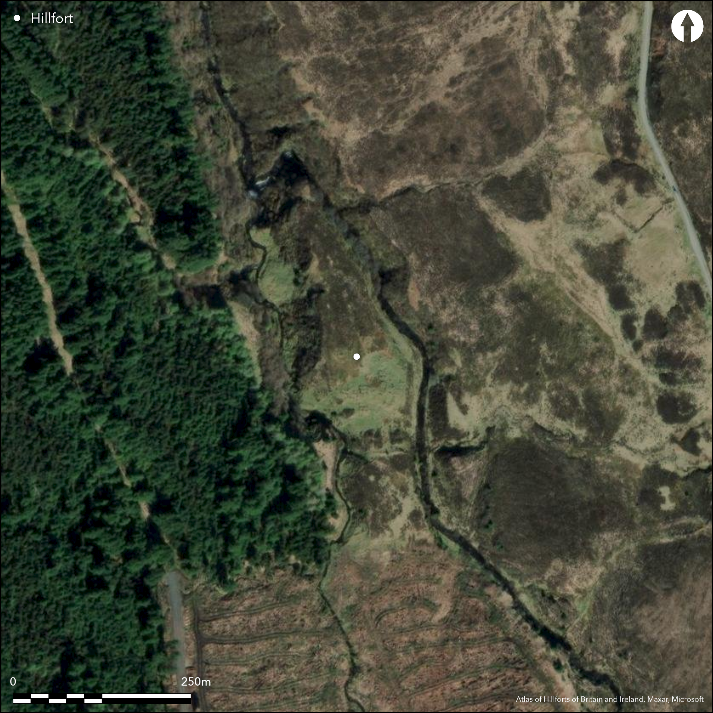
Known by tradition as Annait, a place-name with ecclesiastical associations, this fortification occupies a promontory formed between the gorges of the Bay River and one of its tributaries. There are traces of rubble along the flanks of the promontory, particularly on the E, but the principal defences comprise a wall 43m long blocking access from a shallow saddle on the S. The wall here is up to 5m thick and in places still stands 1.2m high in four course, but there are also traces on this side of a second line of defence set at a slight angle to it, though its comparatively poor state of preservation more probably suggests that it represents an earlier phase of fortification. The entrance, which is 1.9m wide and faced with orthostats, lies towards the W end of the main wall, where several stones set in the body of the wall-core may indicate the presence of some internal structure, such as a gallery; beyond the entrance the wall appears to reduce in thickness. The interior measures about 130m from N to S by up to 50m transversely (0.6ha). Apart from elements of a more extensive group of shielings that clearly overlie the defences, the interior is featureless.
Citizen Science: ✗
Reliability of Data: Confirmed
Reliability of Interpretation: Confirmed
X: -729406 Y: 7859387 (EPSG: 3857)
Longitude: -6.552367398576664 Latitude: 57.482516924998414 (EPSG:4326)
Country: Scotland
Current County or Unitary Authority: Highland
Historic County: Inverness-shire
Current Parish/Community/Council/Townland: Duirinish
None
| Extant | ✓ |
| Cropmark | ✗ |
| Likely Destroyed | ✗ |
None
| Woodland | ✗ |
| Commercial Forestry Plantation | ✗ |
| Parkland | ✗ |
| Pasture (Grazing) | ✓ |
| Arable | ✗ |
| Scrub/Bracken | ✗ |
| Bare Outcrop | ✗ |
| Heather/Moorland | ✓ |
| Heath | ✗ |
| Built-up | ✗ |
| Coastal Grassland | ✗ |
| Other | ✗ |
None
| Contour Fort | ✗ |
| Partial Contour Fort | ✗ |
| Promontory Fort | ✓ |
| Hillslope Fort | ✗ |
| Level Terrain Fort | ✗ |
| Marsh Fort | ✗ |
| Multiple Enclosure Fort | ✗ |
| Hilltop | ✗ |
| Coastal Promontory | ✗ |
| Inland Promontory | ✓ |
| Valley Bottom | ✗ |
| Knoll/Hillock/Outcrop | ✗ |
| Ridge | ✗ |
| Cliff/Plateau-edge/Scarp | ✗ |
| Hillslope | ✗ |
| Lowland | ✗ |
| Spur | ✗ |
Dominant Topographic Feature: None
| North | ✗ |
| Northeast | ✗ |
| East | ✗ |
| Southeast | ✗ |
| South | ✗ |
| Southwest | ✗ |
| West | ✗ |
| Northwest | ✗ |
| Level | ✓ |
Altitude: 60.0m
N/A
In the absence of excavation, there are neither stratified artefacts nor radiocarbon dates to provide a chronology for the defences.
Reliability: D - None
| Pre 1200BC | ✗ |
| 1200BC - 800BC | ✗ |
| 800BC - 400BC | ✗ |
| 400BC - AD50 | ✗ |
| AD50 - AD400 | ✗ |
| AD400 - AD 800 | ✗ |
| Post AD800 | ✗ |
| Unknown | ✓ |
| Pre Hillfort: | None |
| Post Hillfort: | Overlain by shielings and the 'annait' association may also indicate that it is the site of an early church. |
None
| 1st Identified Written Reference (1773): | Sketch-plan by James Boswell (Pottle and Bennett 1936, 178-83) |
| 1st Identified Map Depiction (1877): | Named in Gothic type and anotated 'burial ground' on the 1st edition OS 6-inch map (Inverness-shire, Skye, 1880, sheet 15) |
| Earthwork Survey (1921): | Plan and description (RCAHMS 1928, 149-50, no.499, fig 214) |
| Other (1936): | Scheduled |
| Other (1971): | Description by the OS |
| Other (1990): | Description and mapping survey by RCAHMS |
Featureless apart from what are probably later shieling huts
None
| None | ✓ |
| Spring | ✗ |
| Stream | ✗ |
| Pool | ✗ |
| Flush | ✗ |
| Well | ✗ |
| Other | ✗ |
Later shielings
| No Known Features | ✗ |
| Round Stone Structures | ✗ |
| Rectangular Stone Structures | ✓ |
| Curvilinear Platforms | ✗ |
| Other Roundhouse Evidence | ✗ |
| Pits | ✗ |
| Quarry Hollows | ✗ |
| Other | ✗ |
None
| No Known Excavation | ✓ |
| Pits | ✗ |
| Postholes | ✗ |
| Roundhouses | ✗ |
| Rectangular Structures | ✗ |
| Roads/Tracks | ✗ |
| Quarry Hollows | ✗ |
| Other | ✗ |
| Nothing Found | ✗ |
None
| No Known Geophysics | ✓ |
| Pits | ✗ |
| Roundhouses | ✗ |
| Rectangular Structures | ✗ |
| Roads/Tracks | ✗ |
| Quarry Hollows | ✗ |
| Other | ✗ |
| Nothing Found | ✗ |
None
| No Known Finds | ✓ |
| Pottery | ✗ |
| Metal | ✗ |
| Metalworking | ✗ |
| Human Bones | ✗ |
| Animal Bones | ✗ |
| Lithics | ✗ |
| Environmental | ✗ |
| Other | ✗ |
Later shielings
| APs Not Checked | ✗ |
| None | ✗ |
| Roundhouses | ✗ |
| Rectangular Structures | ✓ |
| Pits | ✗ |
| Postholes | ✗ |
| Roads/Tracks | ✗ |
| Other | ✗ |
See main summary
| 1: | None |
| 2: | None |
Guard Chambers: ✗
Chevaux de Frise: ✗
| 1. Simple Gap (South): | None |
Single wall cutting off a promontory but possibly extending along its flanks
| Area 1: | 0.6ha. |
| Total: | 0.6ha. |
Total Footprint Area: Noneha.
None
| ✗ | None |
| ✗ | None |
| NE Quadrant: | 1 |
| SE Quadrant: | 1 |
| SW Quadrant: | 1 |
| NW Quadrant: | 0 |
| Total: | 1 |
| Partial Univallate | ✓ |
| Univallate | ✗ |
| Partial Bivallate | ✗ |
| Bivallate | ✗ |
| Partial Multivallate | ✗ |
| Multivallate | ✗ |
| Unknown | ✗ |
| Partial Univallate | ✗ |
| Univallate | ✗ |
| Partial Bivallate | ✗ |
| Bivallate | ✗ |
| Partial Multivallate | ✗ |
| Multivallate | ✗ |
None
| None | ✗ |
| Earthen Bank | ✗ |
| Stone Wall | ✓ |
| Rubble | ✗ |
| Wall-walk | ✗ |
| Evidence of Timber | ✗ |
| Vitrification | ✗ |
| Other Burning | ✗ |
| Palisade | ✗ |
| Counter Scarp Bank | ✗ |
| Berm | ✗ |
| Unfinished | ✗ |
| Other | ✗ |
None
| None | ✗ |
| Earthen Bank | ✗ |
| Stone Wall | ✗ |
| Murus Duplex | ✗ |
| Timber-framed | ✗ |
| Timber-laced | ✗ |
| Vitrification | ✗ |
| Other Burning | ✗ |
| Palisade | ✗ |
| Counter Scarp Bank | ✗ |
| Berm | ✗ |
| Unfinished | ✗ |
| No Known Excavation | ✓ |
| Other | ✗ |
| ✗ | None |
| ✗ | None |
Number of Ditches: None
| ✗ | None |
MacCulloch, J A (1948) The misty Isle of Skye. Stirling (p 42-5)
Pottle and Bennett, F A and C H (1936) Boswell's Journal of a Tour to the Hebrides, 1773. Viking Press : New York (https://www.archive.org/details/boswellsjournalo011419mbp),
RCAHMS (1928) The Royal Commission on the Ancient and Historical Monuments and Constructions of Scotland. Ninth report with inventory of monuments and constructions in the Outer Hebrides, Skye and the Small Isles. HMSO: Edinburgh
RCAHMS (1993) The Royal Commission on the Ancient and Historical Monuments of Scotland. Waternish, Skye and Lochalsh District, Highland Region: an archaeological survey. Edinburgh
Thomas, A C (1971) The early Christian archaeology of north Britain: the Hunter Marshall lectures delivered at the University of Glasgow in January and February 1968. London (p 45-6)
Atlas of Hillforts:
Wikidata:
This work is licensed under CC BY-SA 4.0![]()
![]()
![]() and should be cited as:
and should be cited as:
Lock, Gary and Ralston, Ian. 2024. Atlas of Hillforts of Britain and Ireland. Available at: https://hillforts.arch.ox.ac.uk
Document Version 1.1