Satellite Imagery
Satellite Imagery
HER: Highland HER MHG44721 (None)
NMR: NG 37 SE 2 (11206)
SM: 2850
NGR: NG 3598 7002
X: 135980 Y: 870020 (OSGB36)
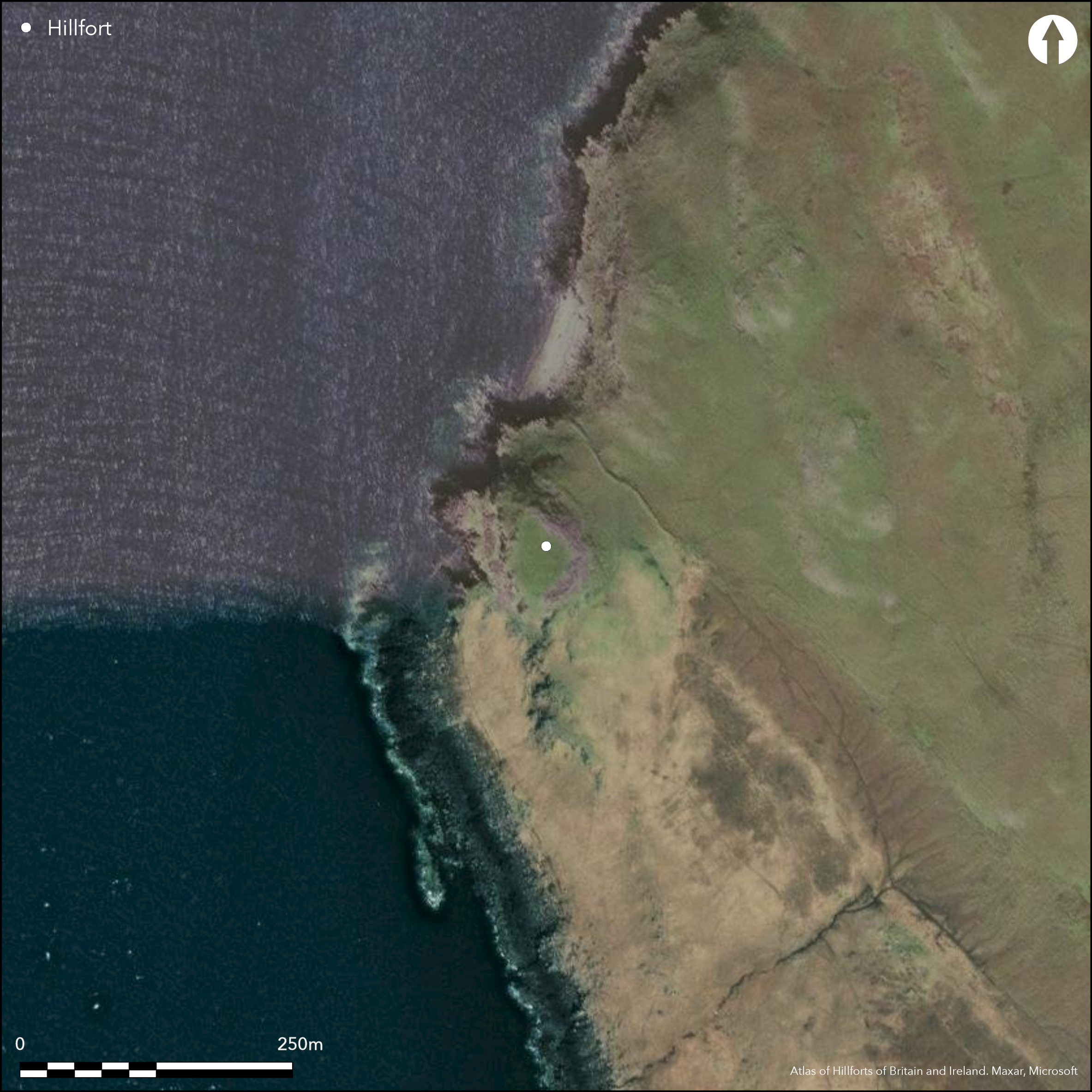
This small fort is situated on a hillock backing onto the shore, which lies at the foot of the cliffs along the W flank. Oval on plan, it measures 42m from NNW to SSE by 24m transversely within a single wall, which is pierced by an entrance a little over 1m wide on the E. The wall is between 2.4m and 3.6m in thickness where best preserved on the E and S, still standing about 1.5m high above the interior on the S; elsewhere it seems to reduce in thickness and most of the masonry has fallen away along the cliff-edge on the seaward side. The wall is thickest where the hillock is most accessible along the E and S flanks, where it has been constructed with an intramural gallery; rather than a continuous feature, however, this is broken into at least four segments, each with an independent entrance from the interior. Immediately outside the wall on the SE there is a row of three upright stones, which Richard Feachem compared to a diminutive chevaux de frise (1963, 186), and beyond this traces of another wall reduced to little more than an intermittent line of outer face, but, rather than the remains of an outwork, the OS surveyors suggested that this might belong to an earlier fortification, presumably on account of its relatively poor state of preservation; other walls on the slopes are almost certainly the remains of later field-banks.
Citizen Science: ✗
Reliability of Data: Confirmed
Reliability of Interpretation: Confirmed
X: -715355 Y: 7892604 (EPSG: 3857)
Longitude: -6.42614528329503 Latitude: 57.64256907414811 (EPSG:4326)
Country: Scotland
Current County or Unitary Authority: Highland
Historic County: Inverness-shire
Current Parish/Community/Council/Townland: Kilmuir
None
| Extant | ✓ |
| Cropmark | ✗ |
| Likely Destroyed | ✗ |
None
| Woodland | ✗ |
| Commercial Forestry Plantation | ✗ |
| Parkland | ✗ |
| Pasture (Grazing) | ✓ |
| Arable | ✗ |
| Scrub/Bracken | ✗ |
| Bare Outcrop | ✗ |
| Heather/Moorland | ✓ |
| Heath | ✗ |
| Built-up | ✗ |
| Coastal Grassland | ✓ |
| Other | ✗ |
None
| Contour Fort | ✓ |
| Partial Contour Fort | ✗ |
| Promontory Fort | ✗ |
| Hillslope Fort | ✗ |
| Level Terrain Fort | ✗ |
| Marsh Fort | ✗ |
| Multiple Enclosure Fort | ✗ |
| Hilltop | ✗ |
| Coastal Promontory | ✗ |
| Inland Promontory | ✗ |
| Valley Bottom | ✗ |
| Knoll/Hillock/Outcrop | ✓ |
| Ridge | ✗ |
| Cliff/Plateau-edge/Scarp | ✗ |
| Hillslope | ✗ |
| Lowland | ✗ |
| Spur | ✗ |
Dominant Topographic Feature: None
| North | ✗ |
| Northeast | ✗ |
| East | ✗ |
| Southeast | ✗ |
| South | ✗ |
| Southwest | ✗ |
| West | ✗ |
| Northwest | ✗ |
| Level | ✓ |
Altitude: 30.0m
N/A
There are neither stratified artefacts nor radiocarbon dates to provide a chronology for the defences.
Reliability: D - None
| Pre 1200BC | ✗ |
| 1200BC - 800BC | ✗ |
| 800BC - 400BC | ✗ |
| 400BC - AD50 | ✗ |
| AD50 - AD400 | ✗ |
| AD400 - AD 800 | ✗ |
| Post AD800 | ✗ |
| Unknown | ✓ |
| Pre Hillfort: | A stone macehead from the site is in Dundee Museum (no. 1956-370) |
| Post Hillfort: | None |
Photographed by RCAHMS Aerial Survey Programme in 2009
| 1st Identified Map Depiction (1875): | Named in Gothic type on the 1st edition OS 25-inch map (Inverness-shire, Skye, 1878, sheet 3.15) |
| Earthwork Survey (1921): | Plan and description (RCAHMS 1928, 169-70, no.541, fig 242; RCAHMS IND 40/1) |
| Other (1963): | Description by Euan Mackie (2007) |
| Excavation (1964): | Trial trench by Euan Mackie (1965) |
| Other (1969): | Scheduled |
| Other (1971): | Visited by the OS |
| Other (1984): | Description and sketch-plan based on the RCAHMS plan (MacSween 53, fig 77) |
A supposed hut-circle identified by RCAHMS investigators in the S end of the interior was though to be a fortuitous arrangement of rubble by the OS. The interior is otherwise featureless.
None
| None | ✓ |
| Spring | ✗ |
| Stream | ✗ |
| Pool | ✗ |
| Flush | ✗ |
| Well | ✗ |
| Other | ✗ |
None
| No Known Features | ✓ |
| Round Stone Structures | ✗ |
| Rectangular Stone Structures | ✗ |
| Curvilinear Platforms | ✗ |
| Other Roundhouse Evidence | ✗ |
| Pits | ✗ |
| Quarry Hollows | ✗ |
| Other | ✗ |
None
| No Known Excavation | ✓ |
| Pits | ✗ |
| Postholes | ✗ |
| Roundhouses | ✗ |
| Rectangular Structures | ✗ |
| Roads/Tracks | ✗ |
| Quarry Hollows | ✗ |
| Other | ✗ |
| Nothing Found | ✗ |
None
| No Known Geophysics | ✓ |
| Pits | ✗ |
| Roundhouses | ✗ |
| Rectangular Structures | ✗ |
| Roads/Tracks | ✗ |
| Quarry Hollows | ✗ |
| Other | ✗ |
| Nothing Found | ✗ |
Few sherds of coarse pottery, a hammer stone and two iron objects found in excavation. A stone macehead from the site is in Dundee Museum (no. 1956-370)
| No Known Finds | ✗ |
| Pottery | ✓ |
| Metal | ✓ |
| Metalworking | ✗ |
| Human Bones | ✗ |
| Animal Bones | ✗ |
| Lithics | ✓ |
| Environmental | ✗ |
| Other | ✗ |
NO APPARENT FEATURES
| APs Not Checked | ✗ |
| None | ✓ |
| Roundhouses | ✗ |
| Rectangular Structures | ✗ |
| Pits | ✗ |
| Postholes | ✗ |
| Roads/Tracks | ✗ |
| Other | ✗ |
See main summary
| 1: | None |
| 2: | None |
Guard Chambers: ✗
Chevaux de Frise: ✗
| 1. Simple Gap (East): | None |
Single wall with galleries; possible outer wall on one side
| Area 1: | 0.08ha. |
| Total: | 0.08ha. |
Total Footprint Area: Noneha.
None
| ✗ | None |
| ✓ | None |
| NE Quadrant: | 1 |
| SE Quadrant: | 2 |
| SW Quadrant: | 1 |
| NW Quadrant: | 1 |
| Total: | 2 |
| Partial Univallate | ✓ |
| Univallate | ✗ |
| Partial Bivallate | ✓ |
| Bivallate | ✗ |
| Partial Multivallate | ✗ |
| Multivallate | ✗ |
| Unknown | ✗ |
| Partial Univallate | ✗ |
| Univallate | ✗ |
| Partial Bivallate | ✗ |
| Bivallate | ✗ |
| Partial Multivallate | ✗ |
| Multivallate | ✗ |
Galleries
| None | ✗ |
| Earthen Bank | ✗ |
| Stone Wall | ✓ |
| Rubble | ✗ |
| Wall-walk | ✗ |
| Evidence of Timber | ✗ |
| Vitrification | ✗ |
| Other Burning | ✗ |
| Palisade | ✗ |
| Counter Scarp Bank | ✗ |
| Berm | ✗ |
| Unfinished | ✗ |
| Other | ✓ |
None
| None | ✗ |
| Earthen Bank | ✗ |
| Stone Wall | ✗ |
| Murus Duplex | ✗ |
| Timber-framed | ✗ |
| Timber-laced | ✗ |
| Vitrification | ✗ |
| Other Burning | ✗ |
| Palisade | ✗ |
| Counter Scarp Bank | ✗ |
| Berm | ✗ |
| Unfinished | ✗ |
| No Known Excavation | ✓ |
| Other | ✗ |
| ✗ | None |
| ✗ | None |
Number of Ditches: None
| ✗ | None |
Feachem, R (1963) A guide to prehistoric Scotland. Batsford: London
MacKie, E W (1965) Excavations on two galleried duns on Skye in 1964-5 (Interim report)
MacKie, E W (2007) The Roundhouses, Brochs and Wheelhouses of Atlantic Scotland c.700 BC-AD 500: architecture and material culture, the Northern and Southern Mainland and the Western Islands, BAR British series 444(II), 444(1), 2 V Oxford
MacSween, A (1985) The Broch, Duns and Enclosures of Skye. Northern Archaeology 5-6 (1984-85), 1-57
RCAHMS (1928) The Royal Commission on the Ancient and Historical Monuments and Constructions of Scotland. Ninth report with inventory of monuments and constructions in the Outer Hebrides, Skye and the Small Isles. HMSO: Edinburgh
Atlas of Hillforts:
Wikidata:
This work is licensed under CC BY-SA 4.0![]()
![]()
![]() and should be cited as:
and should be cited as:
Lock, Gary and Ralston, Ian. 2024. Atlas of Hillforts of Britain and Ireland. Available at: https://hillforts.arch.ox.ac.uk
Document Version 1.1