Satellite Imagery
Satellite Imagery
HER: Highland HER MHG5146 (None)
NMR: NG 44 NE 3 (11271)
SM: 2350
NGR: NG 4892 4527
X: 148920 Y: 845270 (OSGB36)
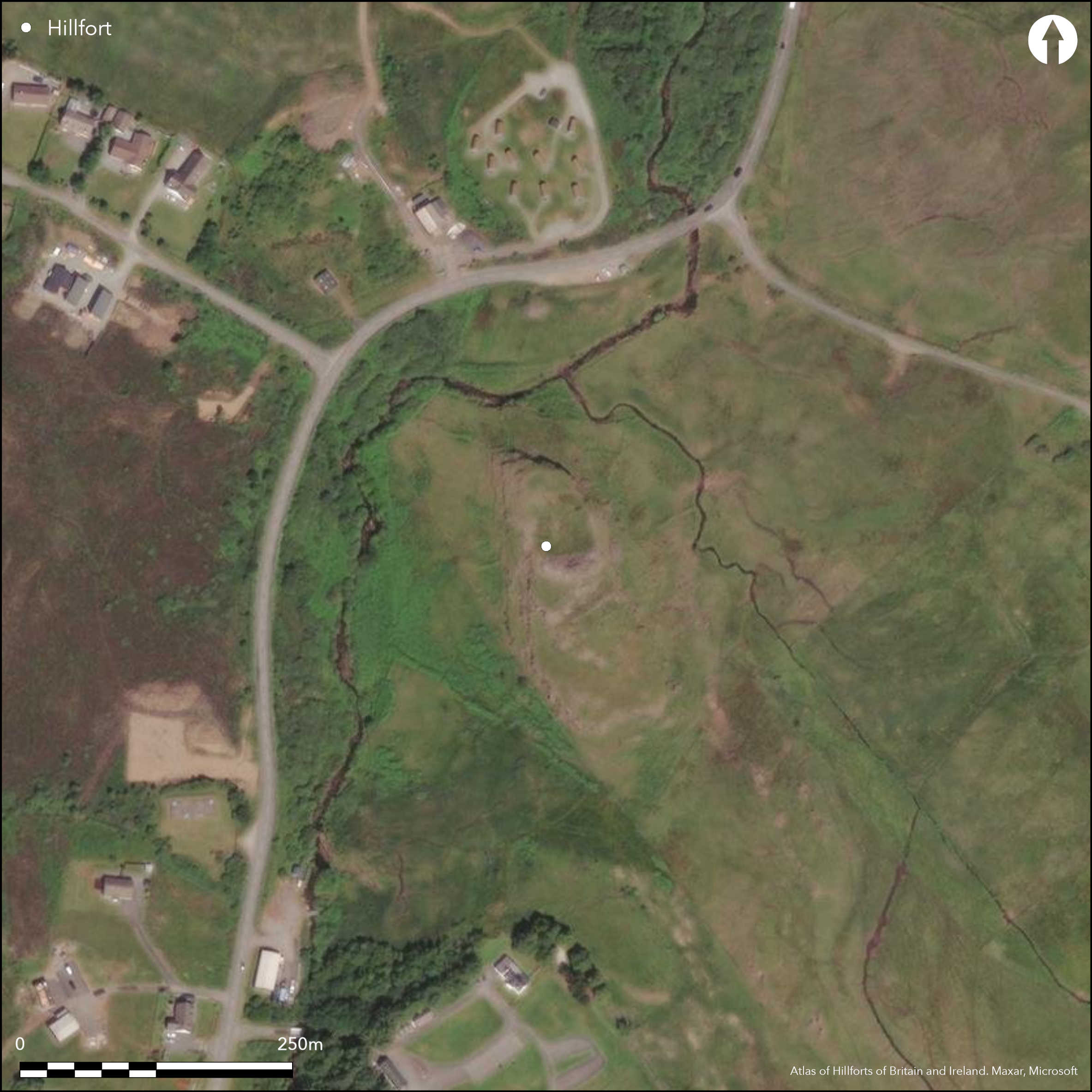
This fort is situated on a low ridge rising a little over 10m above the surrounding land and dropping away sharply around the N, E and W flanks. It is roughly oval on plan, the interior measures about 50m from NNW to SSE by 29m transversely (0.12ha). The main defence comprises a single wall, which on the S attains massive proportions, forming a mound of rubble 10m broad and rising up to 4.5m above the level of the interior; here the wall is about 4.2m thick, though elsewhere on the flanks of the ridge it is between 2.1m and 3.3m thick. There is an entrance on the ENE, but the OS suggested there was a second towards the S end of the W side. In addition to the wall at least four rows of upright boulders have been extended at intervals partly or wholly across the accessible SSE end of the ridge, though whether these are really part of the defences, to impede the easiest line of approach, as was first suggested by RCAHMS investigators in 1921 (RCAHMS 1928, 182-3, no. 577, fig 260), or are simply the result of later activity on the ridge is uncertain. Notably they are strung in a belt 20m deep across the ridge in straight lines up to 35m in length that make no attempt to replicate the curve of the wall. The fort certainly lies within a post medieval agricultural landscape, traces of which can be seen all round, and the stony foundations visible within the interior include two that are probably of relatively recent date and seem to be butted against the line of the wall.
Citizen Science: ✓
Reliability of Data: Confirmed
Reliability of Interpretation: Confirmed
X: -688450 Y: 7848155 (EPSG: 3857)
Longitude: -6.184449393309657 Latitude: 57.4282385249008 (EPSG:4326)
Country: Scotland
Current County or Unitary Authority: Highland
Historic County: Inverness-shire
Current Parish/Community/Council/Townland: Portree
None
| Extant | ✓ |
| Cropmark | ✗ |
| Likely Destroyed | ✗ |
None
| Woodland | ✗ |
| Commercial Forestry Plantation | ✗ |
| Parkland | ✗ |
| Pasture (Grazing) | ✓ |
| Arable | ✗ |
| Scrub/Bracken | ✗ |
| Bare Outcrop | ✗ |
| Heather/Moorland | ✓ |
| Heath | ✗ |
| Built-up | ✗ |
| Coastal Grassland | ✗ |
| Other | ✗ |
None
| Contour Fort | ✓ |
| Partial Contour Fort | ✗ |
| Promontory Fort | ✗ |
| Hillslope Fort | ✗ |
| Level Terrain Fort | ✗ |
| Marsh Fort | ✗ |
| Multiple Enclosure Fort | ✗ |
| Hilltop | ✗ |
| Coastal Promontory | ✗ |
| Inland Promontory | ✗ |
| Valley Bottom | ✗ |
| Knoll/Hillock/Outcrop | ✓ |
| Ridge | ✗ |
| Cliff/Plateau-edge/Scarp | ✗ |
| Hillslope | ✗ |
| Lowland | ✗ |
| Spur | ✗ |
Dominant Topographic Feature: None
| North | ✗ |
| Northeast | ✗ |
| East | ✗ |
| Southeast | ✗ |
| South | ✗ |
| Southwest | ✗ |
| West | ✗ |
| Northwest | ✗ |
| Level | ✓ |
Altitude: 110.0m
N/A
In the absence of excavation, there are neither stratified artefacts nor radiocarbon dates to provide a chronology for the defences.
Reliability: D - None
| Pre 1200BC | ✗ |
| 1200BC - 800BC | ✗ |
| 800BC - 400BC | ✗ |
| 400BC - AD50 | ✗ |
| AD50 - AD400 | ✗ |
| AD400 - AD 800 | ✗ |
| Post AD800 | ✗ |
| Unknown | ✓ |
| Pre Hillfort: | None |
| Post Hillfort: | Later structures within the interior |
The RCAHMS collection also holds undated sketch-plans of the fort drawn by Christian Maclagan in the second half of the 19th century, which form part of the Society of Antiquaries Manuscript (SAS 467; RCAHMS DC52971-2). Photographed by RCAHMS Aerial Survey Programme in 1989.
| 1st Identified Map Depiction (1877): | Named in Gothic type on the 1st edition OS 6-inch map (Inverness-shire, Skye, 1881, sheet 24) |
| Earthwork Survey (1921): | Plan, description and photographs (RCAHMS 1928, 182-3, no. 577, fig 260; RCAHMS IND 35/1-2) |
| Other (1961): | Visited by the OS |
| Other (1963): | Scheduled |
| Other (1984): | Description and sketch-plan based on the RCAHMS plan (MacSween 53, fig 73) |
Several stony foundations at the northern end appear to post-date the fort
None
| None | ✓ |
| Spring | ✗ |
| Stream | ✗ |
| Pool | ✗ |
| Flush | ✗ |
| Well | ✗ |
| Other | ✗ |
Several later foundations, probably the remains of small folds and shelters
| No Known Features | ✗ |
| Round Stone Structures | ✗ |
| Rectangular Stone Structures | ✗ |
| Curvilinear Platforms | ✗ |
| Other Roundhouse Evidence | ✗ |
| Pits | ✗ |
| Quarry Hollows | ✗ |
| Other | ✓ |
None
| No Known Excavation | ✓ |
| Pits | ✗ |
| Postholes | ✗ |
| Roundhouses | ✗ |
| Rectangular Structures | ✗ |
| Roads/Tracks | ✗ |
| Quarry Hollows | ✗ |
| Other | ✗ |
| Nothing Found | ✗ |
None
| No Known Geophysics | ✓ |
| Pits | ✗ |
| Roundhouses | ✗ |
| Rectangular Structures | ✗ |
| Roads/Tracks | ✗ |
| Quarry Hollows | ✗ |
| Other | ✗ |
| Nothing Found | ✗ |
None
| No Known Finds | ✓ |
| Pottery | ✗ |
| Metal | ✗ |
| Metalworking | ✗ |
| Human Bones | ✗ |
| Animal Bones | ✗ |
| Lithics | ✗ |
| Environmental | ✗ |
| Other | ✗ |
Several later foundations, probably the remains of small folds and shelters
| APs Not Checked | ✗ |
| None | ✗ |
| Roundhouses | ✗ |
| Rectangular Structures | ✗ |
| Pits | ✗ |
| Postholes | ✗ |
| Roads/Tracks | ✗ |
| Other | ✓ |
See main summary
| 2: | None |
| 2: | None |
Guard Chambers: ✗
Chevaux de Frise: ✓
Spaced rows of boulders, rather than a close-set belt
| 1. Simple Gap (East): | None |
| 2. Simple Gap (South west): | None |
Single wall, possibly with chevaux de frise type outworks on one side (Feachem 1963, 156)
| Area 1: | 0.12ha. |
| Total: | 0.12ha. |
Total Footprint Area: 0.27ha.
None
| ✗ | None |
| ✓ | None |
| NE Quadrant: | 1 |
| SE Quadrant: | 1 |
| SW Quadrant: | 1 |
| NW Quadrant: | 1 |
| Total: | 1 |
| Partial Univallate | ✗ |
| Univallate | ✓ |
| Partial Bivallate | ✗ |
| Bivallate | ✗ |
| Partial Multivallate | ✗ |
| Multivallate | ✗ |
| Unknown | ✗ |
| Partial Univallate | ✗ |
| Univallate | ✗ |
| Partial Bivallate | ✗ |
| Bivallate | ✗ |
| Partial Multivallate | ✗ |
| Multivallate | ✗ |
None
| None | ✗ |
| Earthen Bank | ✗ |
| Stone Wall | ✓ |
| Rubble | ✗ |
| Wall-walk | ✗ |
| Evidence of Timber | ✗ |
| Vitrification | ✗ |
| Other Burning | ✗ |
| Palisade | ✗ |
| Counter Scarp Bank | ✗ |
| Berm | ✗ |
| Unfinished | ✗ |
| Other | ✗ |
None
| None | ✗ |
| Earthen Bank | ✗ |
| Stone Wall | ✗ |
| Murus Duplex | ✗ |
| Timber-framed | ✗ |
| Timber-laced | ✗ |
| Vitrification | ✗ |
| Other Burning | ✗ |
| Palisade | ✗ |
| Counter Scarp Bank | ✗ |
| Berm | ✗ |
| Unfinished | ✗ |
| No Known Excavation | ✓ |
| Other | ✗ |
| ✗ | None |
| ✗ | None |
Number of Ditches: None
| ✗ | None |
Feachem, R (1963) A guide to prehistoric Scotland. Batsford: London
MacSween, A (1985) The Broch, Duns and Enclosures of Skye. Northern Archaeology 5-6 (1984-85), 1-57
Name Book, Ordnance Survey Object Name Books (6 inch and 1/2500 scale); available https://www.scotlandsplaces.gov.uk/. Inverness-shire, Skye, No. 9, p 42
RCAHMS (1928) The Royal Commission on the Ancient and Historical Monuments and Constructions of Scotland. Ninth report with inventory of monuments and constructions in the Outer Hebrides, Skye and the Small Isles. HMSO: Edinburgh
Atlas of Hillforts:
Wikidata:
This work is licensed under CC BY-SA 4.0![]()
![]()
![]() and should be cited as:
and should be cited as:
Lock, Gary and Ralston, Ian. 2024. Atlas of Hillforts of Britain and Ireland. Available at: https://hillforts.arch.ox.ac.uk
Document Version 1.1