Satellite Imagery
Satellite Imagery
HER: Highland HER MHG5117 (None)
NMR: NG 44 SE 2 (11300)
SM: None
NGR: NG 4937 4422
X: 149370 Y: 844220 (OSGB36)
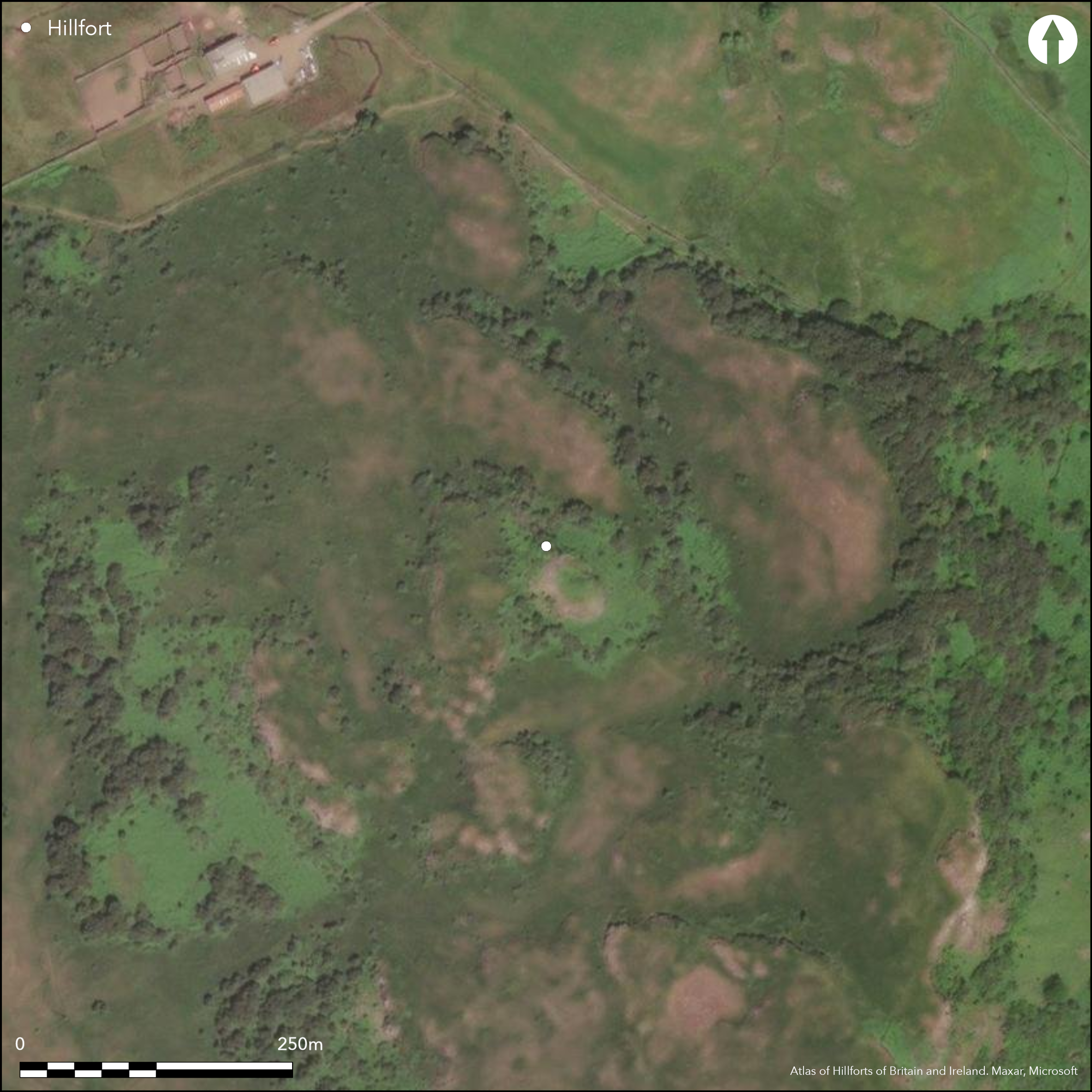
The remains of this fortification are situated on a hillock on the W flank of Ben Chracaig, which rises up on the NE side of the bay at Portree. Rising over 10m above the surrounding ground, the summit is only easily accessible from the W, where the approach is barred by at least two strong walls to create a small promontory work. The wall of the inner enclosure has been reduced largely to a mound of rubble up to 9m in thickness by 2m in height, within which a length of the outer face of a substantial structure can be seen in the central sector. About 8m outside this wall there is a second line of defence, recorded on the RCAHMS plan drawn up in 1921 (RCAHMS 1928, 183-4, no.578, fig 261) as two concentric walls, each little more than 1m in thickness, swinging round the W flank, and the inner apparently returning back along the N flank towards the inner enclosure; these outer lines are pierced by an entrance 1.15 wide on the W close to the S margin of the hillock, but aligned NE and SW. Set only 3m apart, these are an unusual feature, and there is a possibility that, rather than being two, they represent the robbed out remains of a single massive wall. If so, this probably represents an earlier line of defence, cutting off an area measuring about 30m from NW to SE by 15m transversely (0.04ha), whereas the inner enclosure takes in an area of no more than 20m by 15m transversely (0.03ha). In essence, the latter is probably the remains of a dun inserted into an earlier fort, though there is no evidence that its wall continued round the rocky margins of the hillock. Several features are shown on the RCAHMS plan within the interior, but they are not elaborated in the description and have recieved no commentaries since.
Citizen Science: ✗
Reliability of Data: Confirmed
Reliability of Interpretation: Unconfirmed
X: -687498 Y: 7846262 (EPSG: 3857)
Longitude: -6.175902450692322 Latitude: 57.41907998996104 (EPSG:4326)
Country: Scotland
Current County or Unitary Authority: Highland
Historic County: Inverness-shire
Current Parish/Community/Council/Townland: Portree
None
| Extant | ✓ |
| Cropmark | ✗ |
| Likely Destroyed | ✗ |
None
| Woodland | ✗ |
| Commercial Forestry Plantation | ✗ |
| Parkland | ✗ |
| Pasture (Grazing) | ✓ |
| Arable | ✗ |
| Scrub/Bracken | ✓ |
| Bare Outcrop | ✗ |
| Heather/Moorland | ✓ |
| Heath | ✗ |
| Built-up | ✗ |
| Coastal Grassland | ✗ |
| Other | ✗ |
None
| Contour Fort | ✗ |
| Partial Contour Fort | ✗ |
| Promontory Fort | ✓ |
| Hillslope Fort | ✗ |
| Level Terrain Fort | ✗ |
| Marsh Fort | ✗ |
| Multiple Enclosure Fort | ✗ |
| Hilltop | ✗ |
| Coastal Promontory | ✗ |
| Inland Promontory | ✓ |
| Valley Bottom | ✗ |
| Knoll/Hillock/Outcrop | ✗ |
| Ridge | ✗ |
| Cliff/Plateau-edge/Scarp | ✗ |
| Hillslope | ✗ |
| Lowland | ✗ |
| Spur | ✗ |
Dominant Topographic Feature: None
| North | ✗ |
| Northeast | ✗ |
| East | ✗ |
| Southeast | ✗ |
| South | ✗ |
| Southwest | ✗ |
| West | ✗ |
| Northwest | ✗ |
| Level | ✓ |
Altitude: 120.0m
N/A
In the absence of excavation, there are neither stratified artefacts nor radiocarbon dates to provide a chronology for the defences.
Reliability: D - None
| Pre 1200BC | ✗ |
| 1200BC - 800BC | ✗ |
| 800BC - 400BC | ✗ |
| 400BC - AD50 | ✗ |
| AD50 - AD400 | ✗ |
| AD400 - AD 800 | ✗ |
| Post AD800 | ✗ |
| Unknown | ✓ |
| Pre Hillfort: | None |
| Post Hillfort: | Probably saw the construction of a dun |
None
| 1st Identified Map Depiction (1877): | Named in Gothic type on the 1st edition OS 25-inch map (Inverness-shire, Skye, 1881, sheet 24.13) |
| Earthwork Survey (1921): | Plan and description (RCAHMS 1928, 183-4, no.578, fig 261) |
| Earthwork Survey (1971): | Visited by the OS and planned at 1:500 |
| Other (1984): | Description and sketch-plan based on the RCAHMS plan (MacSween 53, fig 74) |
Several circular features are shown on the RCAHMS plan of 1921, but their character is unknown
None
| None | ✓ |
| Spring | ✗ |
| Stream | ✗ |
| Pool | ✗ |
| Flush | ✗ |
| Well | ✗ |
| Other | ✗ |
Character unknown. The innermost wall is likely to be a later dun
| No Known Features | ✗ |
| Round Stone Structures | ✗ |
| Rectangular Stone Structures | ✗ |
| Curvilinear Platforms | ✗ |
| Other Roundhouse Evidence | ✗ |
| Pits | ✗ |
| Quarry Hollows | ✗ |
| Other | ✓ |
None
| No Known Excavation | ✓ |
| Pits | ✗ |
| Postholes | ✗ |
| Roundhouses | ✗ |
| Rectangular Structures | ✗ |
| Roads/Tracks | ✗ |
| Quarry Hollows | ✗ |
| Other | ✗ |
| Nothing Found | ✗ |
None
| No Known Geophysics | ✓ |
| Pits | ✗ |
| Roundhouses | ✗ |
| Rectangular Structures | ✗ |
| Roads/Tracks | ✗ |
| Quarry Hollows | ✗ |
| Other | ✗ |
| Nothing Found | ✗ |
None
| No Known Finds | ✓ |
| Pottery | ✗ |
| Metal | ✗ |
| Metalworking | ✗ |
| Human Bones | ✗ |
| Animal Bones | ✗ |
| Lithics | ✗ |
| Environmental | ✗ |
| Other | ✗ |
NO APPARENT FEATURES
| APs Not Checked | ✓ |
| None | ✗ |
| Roundhouses | ✗ |
| Rectangular Structures | ✗ |
| Pits | ✗ |
| Postholes | ✗ |
| Roads/Tracks | ✗ |
| Other | ✗ |
See main summary
| 1: | Incomplete circuits |
| 2: | None |
Guard Chambers: ✗
Chevaux de Frise: ✗
| 1. Simple Gap (West): | In the outer defences and aligned NE and SW |
At least two walls, probably successive, cutting off a promontory
| Area 1: | 0.04ha. |
| Total: | 0.04ha. |
Total Footprint Area: Noneha.
None
| ✗ | Excludes the inner enclosure on the grounds that it is probably a dun |
| ✗ | This excludes the inner wall on the grounds that it is more probably a dun |
| NE Quadrant: | 0 |
| SE Quadrant: | 0 |
| SW Quadrant: | 0 |
| NW Quadrant: | 1 |
| Total: | 1 |
| Partial Univallate | ✓ |
| Univallate | ✗ |
| Partial Bivallate | ✗ |
| Bivallate | ✗ |
| Partial Multivallate | ✗ |
| Multivallate | ✗ |
| Unknown | ✗ |
| Partial Univallate | ✗ |
| Univallate | ✗ |
| Partial Bivallate | ✗ |
| Bivallate | ✗ |
| Partial Multivallate | ✗ |
| Multivallate | ✗ |
None
| None | ✗ |
| Earthen Bank | ✗ |
| Stone Wall | ✓ |
| Rubble | ✗ |
| Wall-walk | ✗ |
| Evidence of Timber | ✗ |
| Vitrification | ✗ |
| Other Burning | ✗ |
| Palisade | ✗ |
| Counter Scarp Bank | ✗ |
| Berm | ✗ |
| Unfinished | ✗ |
| Other | ✗ |
None
| None | ✗ |
| Earthen Bank | ✗ |
| Stone Wall | ✗ |
| Murus Duplex | ✗ |
| Timber-framed | ✗ |
| Timber-laced | ✗ |
| Vitrification | ✗ |
| Other Burning | ✗ |
| Palisade | ✗ |
| Counter Scarp Bank | ✗ |
| Berm | ✗ |
| Unfinished | ✗ |
| No Known Excavation | ✓ |
| Other | ✗ |
| ✗ | None |
| ✗ | None |
Number of Ditches: None
| ✗ | None |
MacSween, A (1985) The Broch, Duns and Enclosures of Skye. Northern Archaeology 5-6 (1984-85), 1-57
RCAHMS (1928) The Royal Commission on the Ancient and Historical Monuments and Constructions of Scotland. Ninth report with inventory of monuments and constructions in the Outer Hebrides, Skye and the Small Isles. HMSO: Edinburgh
Atlas of Hillforts:
Wikidata:
This work is licensed under CC BY-SA 4.0![]()
![]()
![]() and should be cited as:
and should be cited as:
Lock, Gary and Ralston, Ian. 2024. Atlas of Hillforts of Britain and Ireland. Available at: https://hillforts.arch.ox.ac.uk
Document Version 1.1