Satellite Imagery
Satellite Imagery
HER: Highland HER MHG45372 (None)
NMR: NG 82 NE 3 (11823)
SM: 7575
NGR: NG 8812 2583
X: 188127 Y: 825836 (OSGB36)
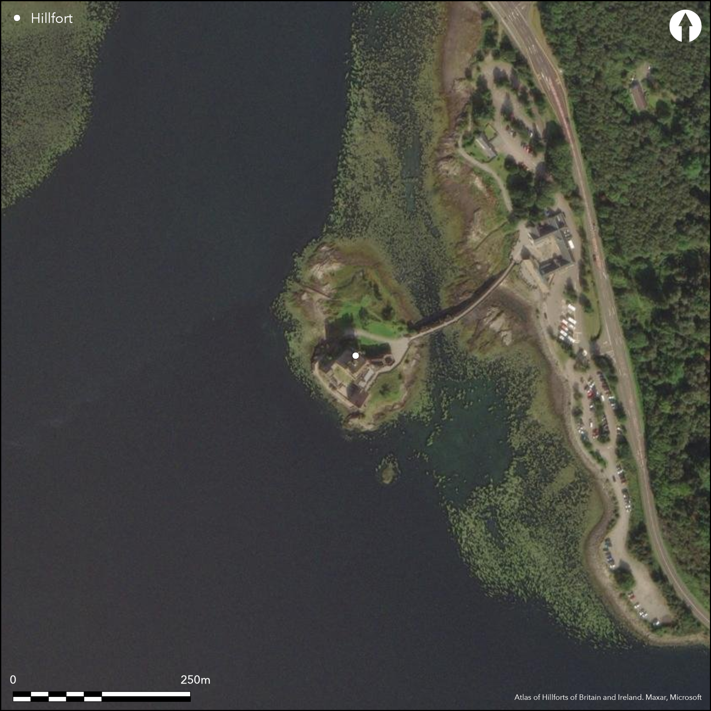
The medieval castle on the small tidal island of Eilean Donan, heavily restored in the early 20th century, may have occupied the site of an earlier fort, though evaluations in 2008 and further excavation in 2009 and 2010 did not encounter any remains of it. A length of collapsed walling on the NW side of the bridge that now connects the island contains fragments of vitrified stone, though the wall itself probably belongs to the more recent defences.
Citizen Science: ✗
Reliability of Data: Unconfirmed
Reliability of Interpretation: Unconfirmed
X: -614051 Y: 7816323 (EPSG: 3857)
Longitude: -5.516110790879617 Latitude: 57.27397084577025 (EPSG:4326)
Country: Scotland
Current County or Unitary Authority: Highland
Historic County: Ross-shire
Current Parish/Community/Council/Townland: Kintail
None
| Extant | ✓ |
| Cropmark | ✗ |
| Likely Destroyed | ✓ |
None
| Woodland | ✗ |
| Commercial Forestry Plantation | ✗ |
| Parkland | ✗ |
| Pasture (Grazing) | ✗ |
| Arable | ✗ |
| Scrub/Bracken | ✗ |
| Bare Outcrop | ✗ |
| Heather/Moorland | ✗ |
| Heath | ✗ |
| Built-up | ✓ |
| Coastal Grassland | ✓ |
| Other | ✗ |
The form of this fort is uncertain, occupying a tidal island
| Contour Fort | ✗ |
| Partial Contour Fort | ✗ |
| Promontory Fort | ✗ |
| Hillslope Fort | ✗ |
| Level Terrain Fort | ✗ |
| Marsh Fort | ✗ |
| Multiple Enclosure Fort | ✗ |
| Hilltop | ✗ |
| Coastal Promontory | ✗ |
| Inland Promontory | ✗ |
| Valley Bottom | ✗ |
| Knoll/Hillock/Outcrop | ✗ |
| Ridge | ✗ |
| Cliff/Plateau-edge/Scarp | ✗ |
| Hillslope | ✗ |
| Lowland | ✗ |
| Spur | ✗ |
Dominant Topographic Feature: None
| North | ✗ |
| Northeast | ✗ |
| East | ✗ |
| Southeast | ✗ |
| South | ✗ |
| Southwest | ✗ |
| West | ✗ |
| Northwest | ✗ |
| Level | ✓ |
Altitude: 5.0m
N/A
The character and date of any earlier occupation here can only be demonstrated by excavation
Reliability: D - None
| Pre 1200BC | ✗ |
| 1200BC - 800BC | ✗ |
| 800BC - 400BC | ✗ |
| 400BC - AD50 | ✗ |
| AD50 - AD400 | ✗ |
| AD400 - AD 800 | ✗ |
| Post AD800 | ✗ |
| Unknown | ✓ |
| Pre Hillfort: | None |
| Post Hillfort: | Occupied by a medieval castle |
While the ruins of the castle had long been a local landmark, the first mention of the wall containing virtified stones is by T Wallace in 1921. Referencing of the castle is omitted here. 1998
| 1st Identified Written Reference (1921): | Wall and vitrifaction noted (Wallace 1921, 109) |
| Other (1966): | Visited by the OS |
| Other (1974): | Visited by the OS |
| Other (1998): | Scheduled |
| Excavation (2008): | Evaluation (Field Archaeology Specialists Ltd, 2008) |
| Excavation (2009): | Area excavation (Field Archaeology Specialists Ltd, 2009) |
| Excavation (2010): | Area excavation (Field Archaeology Specialists Ltd, 2010) |
Occupied by the castle
None
| None | ✓ |
| Spring | ✗ |
| Stream | ✗ |
| Pool | ✗ |
| Flush | ✗ |
| Well | ✗ |
| Other | ✗ |
None
| No Known Features | ✓ |
| Round Stone Structures | ✗ |
| Rectangular Stone Structures | ✗ |
| Curvilinear Platforms | ✗ |
| Other Roundhouse Evidence | ✗ |
| Pits | ✗ |
| Quarry Hollows | ✗ |
| Other | ✗ |
None
| No Known Excavation | ✓ |
| Pits | ✗ |
| Postholes | ✗ |
| Roundhouses | ✗ |
| Rectangular Structures | ✗ |
| Roads/Tracks | ✗ |
| Quarry Hollows | ✗ |
| Other | ✗ |
| Nothing Found | ✗ |
None
| No Known Geophysics | ✓ |
| Pits | ✗ |
| Roundhouses | ✗ |
| Rectangular Structures | ✗ |
| Roads/Tracks | ✗ |
| Quarry Hollows | ✗ |
| Other | ✗ |
| Nothing Found | ✗ |
None
| No Known Finds | ✓ |
| Pottery | ✗ |
| Metal | ✗ |
| Metalworking | ✗ |
| Human Bones | ✗ |
| Animal Bones | ✗ |
| Lithics | ✗ |
| Environmental | ✗ |
| Other | ✗ |
NO APPARENT FEATURES
| APs Not Checked | ✗ |
| None | ✓ |
| Roundhouses | ✗ |
| Rectangular Structures | ✗ |
| Pits | ✗ |
| Postholes | ✗ |
| Roads/Tracks | ✗ |
| Other | ✗ |
None known
| 0: | None |
| 2: | Not known |
Guard Chambers: ✗
Chevaux de Frise: ✗
Vitrifaction, but no other evidence
| Area 1: | Noneha. |
| Total: | Noneha. |
Total Footprint Area: Noneha.
None
| ✗ | Size unknown, but the higher part of the island extends to only 0.17ha |
| ✗ | Nothing known about the defences |
| NE Quadrant: | 0 |
| SE Quadrant: | 0 |
| SW Quadrant: | 0 |
| NW Quadrant: | 0 |
| Total: | 0 |
| Partial Univallate | ✗ |
| Univallate | ✗ |
| Partial Bivallate | ✗ |
| Bivallate | ✗ |
| Partial Multivallate | ✗ |
| Multivallate | ✗ |
| Unknown | ✓ |
| Partial Univallate | ✗ |
| Univallate | ✗ |
| Partial Bivallate | ✗ |
| Bivallate | ✗ |
| Partial Multivallate | ✗ |
| Multivallate | ✗ |
None
| None | ✗ |
| Earthen Bank | ✗ |
| Stone Wall | ✗ |
| Rubble | ✗ |
| Wall-walk | ✗ |
| Evidence of Timber | ✗ |
| Vitrification | ✓ |
| Other Burning | ✗ |
| Palisade | ✗ |
| Counter Scarp Bank | ✗ |
| Berm | ✗ |
| Unfinished | ✗ |
| Other | ✗ |
No evidence of the earlier defences recorded
| None | ✓ |
| Earthen Bank | ✗ |
| Stone Wall | ✗ |
| Murus Duplex | ✗ |
| Timber-framed | ✗ |
| Timber-laced | ✗ |
| Vitrification | ✗ |
| Other Burning | ✗ |
| Palisade | ✗ |
| Counter Scarp Bank | ✗ |
| Berm | ✗ |
| Unfinished | ✗ |
| No Known Excavation | ✗ |
| Other | ✗ |
| ✗ | None |
| ✗ | None |
Number of Ditches: None
| ✗ | None |
Field Archaeology Specialists Ltd (2008) 'Eilean Donan Castle, Highland (Kintail parish), geophysical survey, topographical survey and evaluation'. Disc Exc Scot, New Ser, 9 (2008), 110
Field Archaeology Specialists Ltd (2009) 'Eilean Donan Castle, Highland (Kintail parish), excavation'. Disc Exc Scot, New Ser, 10 (2009), 104
Field Archaeology Specialists Ltd (2010) 'Eilean Donan Castle, Highland (Kintail parish), watching brief and excavation'. Disc Exc Scot, New Ser, 11 (2010), 98
Wallace, T (1921) 'Archaeological notes'. Trans Inverness Sci Soc Fld Club 8 (1921), 109
Atlas of Hillforts:
Wikidata:
This work is licensed under CC BY-SA 4.0![]()
![]()
![]() and should be cited as:
and should be cited as:
Lock, Gary and Ralston, Ian. 2024. Atlas of Hillforts of Britain and Ireland. Available at: https://hillforts.arch.ox.ac.uk
Document Version 1.1