Satellite Imagery
Satellite Imagery
HER: Comhairle nan Eilean Siar - Western Isles Sites and Monuments Record MWE9742 (None)
NMR: NF 60 SW 4 (9742)
SM: 5098
NGR: NF 6311 0037
X: 63110 Y: 800370 (OSGB36)
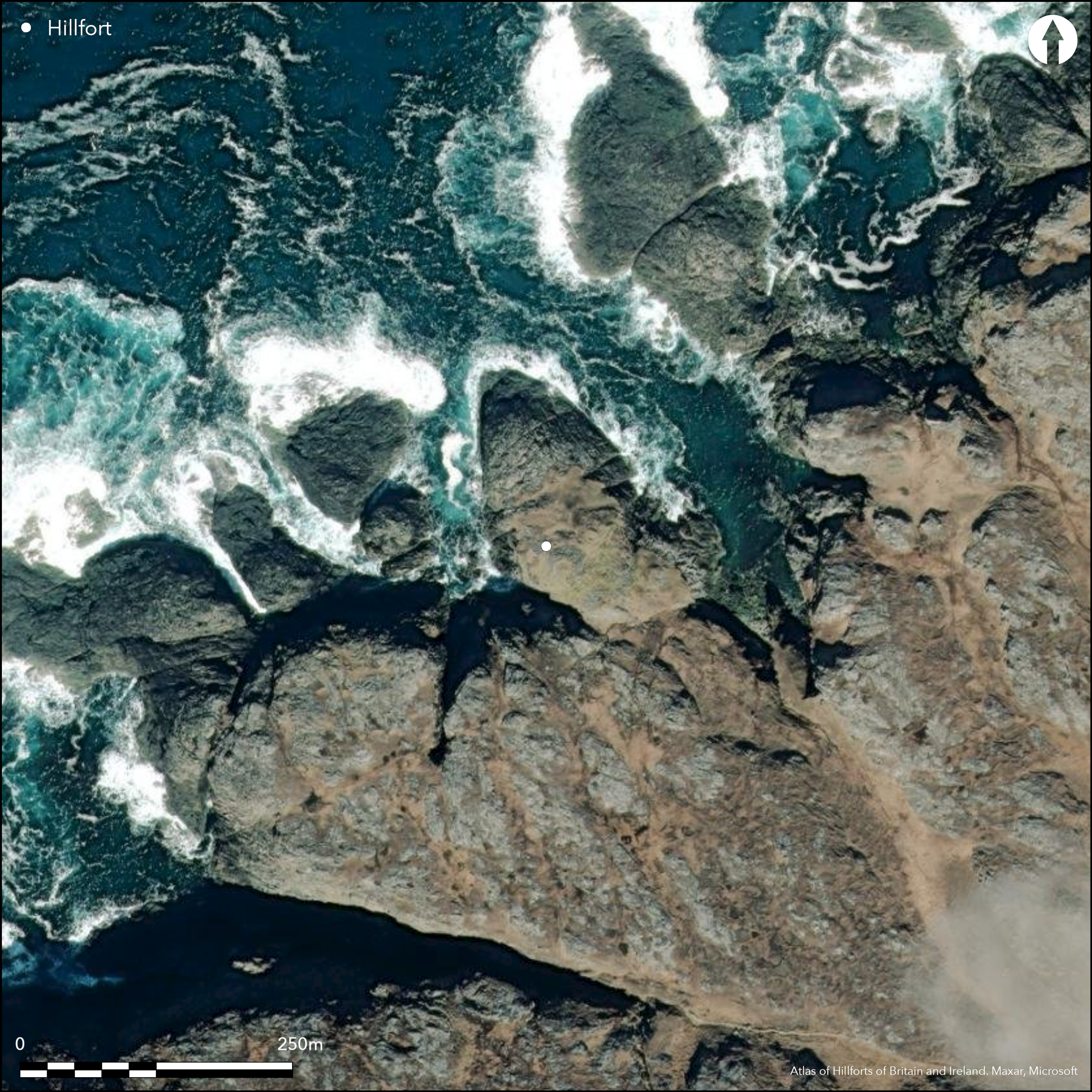
This fortification occupies a promontory on the NW coast of the Tangaval peninsular, which forms the SW extremity of Barra. The promontory is girt with cliffs up to 12m high, dropping sheer into the sea on the SW, while the outcrops on the seaward side of hollow cutting from E to W across its neck provide a natural line line of defence which has been exploited by a single wall. In places the wall stands 1m high and a gap at its E end is probably the entrance. The rocky interior is rough and uneven, and measures about 120m from NW to SE by a maximum of 65m transversely (0.5ha), though about a third of this area at the seaward end is exposed bedrock. The only feature visible within the interior is the tumbled ruin of a broch occupying the summit; measuring about 18m in diameter over a wall 4m in thickness and up to 1.2m in height, it has a possible entrance on the E.
Citizen Science: ✗
Reliability of Data: Confirmed
Reliability of Interpretation: Confirmed
X: -840077 Y: 7754271 (EPSG: 3857)
Longitude: -7.5465361933793735 Latitude: 56.971380458831064 (EPSG:4326)
Country: Scotland
Current County or Unitary Authority: Western Isles
Historic County: Inverness-shire
Current Parish/Community/Council/Townland: Barra
None
| Extant | ✓ |
| Cropmark | ✗ |
| Likely Destroyed | ✗ |
None
| Woodland | ✗ |
| Commercial Forestry Plantation | ✗ |
| Parkland | ✗ |
| Pasture (Grazing) | ✓ |
| Arable | ✗ |
| Scrub/Bracken | ✗ |
| Bare Outcrop | ✗ |
| Heather/Moorland | ✓ |
| Heath | ✗ |
| Built-up | ✗ |
| Coastal Grassland | ✓ |
| Other | ✗ |
None
| Contour Fort | ✗ |
| Partial Contour Fort | ✗ |
| Promontory Fort | ✓ |
| Hillslope Fort | ✗ |
| Level Terrain Fort | ✗ |
| Marsh Fort | ✗ |
| Multiple Enclosure Fort | ✗ |
| Hilltop | ✗ |
| Coastal Promontory | ✓ |
| Inland Promontory | ✗ |
| Valley Bottom | ✗ |
| Knoll/Hillock/Outcrop | ✗ |
| Ridge | ✗ |
| Cliff/Plateau-edge/Scarp | ✗ |
| Hillslope | ✗ |
| Lowland | ✗ |
| Spur | ✗ |
Dominant Topographic Feature: None
| North | ✗ |
| Northeast | ✗ |
| East | ✗ |
| Southeast | ✗ |
| South | ✗ |
| Southwest | ✗ |
| West | ✗ |
| Northwest | ✗ |
| Level | ✓ |
Altitude: 15.0m
N/A
The pottery found here and its comparisons to the broch on Dun Cuier (Young 1956, 293), may have no bearing on the dating of the outer defence.
Reliability: D - None
| Pre 1200BC | ✗ |
| 1200BC - 800BC | ✗ |
| 800BC - 400BC | ✗ |
| 400BC - AD50 | ✗ |
| AD50 - AD400 | ✗ |
| AD400 - AD 800 | ✗ |
| Post AD800 | ✗ |
| Unknown | ✓ |
| Pre Hillfort: | None |
| Post Hillfort: | Possibly the construction of the broch |
| Artefactual: | Pottery |
Photographed by RCAHMS Aerial Survey Programme in 2005, and the RCAHMS collection also contains ground photographs by Mary Harman taken in 1976.
| 1st Identified Map Depiction (1878): | Named in Gothic type on the 1st edition OS 6-inch map (Inverness-shire, Hebrides, 1880, sheet 64) |
| Other (1915): | Description (RCAHMS 1928, 131, no.446) |
| Other (1956): | Visited by Alison Young (1956, 292-3, fig 2.8; 1962, 193) |
| Other (1965): | Surveyed at 1:10,560 & 1:2500 by the OS |
| Other (1991): | Description (Branigan and Foster 1995, 84; RCAHMS MS595/6) |
| Other (2005): | Scheduled |
Featureless apart from the broch
None
| None | ✓ |
| Spring | ✗ |
| Stream | ✗ |
| Pool | ✗ |
| Flush | ✗ |
| Well | ✗ |
| Other | ✗ |
Broch
| No Known Features | ✗ |
| Round Stone Structures | ✗ |
| Rectangular Stone Structures | ✗ |
| Curvilinear Platforms | ✗ |
| Other Roundhouse Evidence | ✗ |
| Pits | ✗ |
| Quarry Hollows | ✗ |
| Other | ✓ |
None
| No Known Excavation | ✓ |
| Pits | ✗ |
| Postholes | ✗ |
| Roundhouses | ✗ |
| Rectangular Structures | ✗ |
| Roads/Tracks | ✗ |
| Quarry Hollows | ✗ |
| Other | ✗ |
| Nothing Found | ✗ |
None
| No Known Geophysics | ✓ |
| Pits | ✗ |
| Roundhouses | ✗ |
| Rectangular Structures | ✗ |
| Roads/Tracks | ✗ |
| Quarry Hollows | ✗ |
| Other | ✗ |
| Nothing Found | ✗ |
Pottery comparable to material from Dun Cuier and hammerstones recovered (Young 1956, 292-3, fig 2.8)
| No Known Finds | ✗ |
| Pottery | ✓ |
| Metal | ✗ |
| Metalworking | ✗ |
| Human Bones | ✗ |
| Animal Bones | ✗ |
| Lithics | ✓ |
| Environmental | ✗ |
| Other | ✗ |
NO APPARENT FEATURES
| APs Not Checked | ✗ |
| None | ✓ |
| Roundhouses | ✗ |
| Rectangular Structures | ✗ |
| Pits | ✗ |
| Postholes | ✗ |
| Roads/Tracks | ✗ |
| Other | ✗ |
See main summary
| 1: | None |
| 2: | None |
Guard Chambers: ✗
Chevaux de Frise: ✗
| 1. Simple Gap (South east): | None |
Single wall across a promontory
| Area 1: | 0.5ha. |
| Total: | 0.5ha. |
Total Footprint Area: Noneha.
None
| ✗ | None |
| ✗ | This excludes the broch wall |
| NE Quadrant: | 0 |
| SE Quadrant: | 1 |
| SW Quadrant: | 0 |
| NW Quadrant: | 0 |
| Total: | 1 |
| Partial Univallate | ✓ |
| Univallate | ✗ |
| Partial Bivallate | ✗ |
| Bivallate | ✗ |
| Partial Multivallate | ✗ |
| Multivallate | ✗ |
| Unknown | ✗ |
| Partial Univallate | ✗ |
| Univallate | ✗ |
| Partial Bivallate | ✗ |
| Bivallate | ✗ |
| Partial Multivallate | ✗ |
| Multivallate | ✗ |
None
| None | ✗ |
| Earthen Bank | ✗ |
| Stone Wall | ✓ |
| Rubble | ✗ |
| Wall-walk | ✗ |
| Evidence of Timber | ✗ |
| Vitrification | ✗ |
| Other Burning | ✗ |
| Palisade | ✗ |
| Counter Scarp Bank | ✗ |
| Berm | ✗ |
| Unfinished | ✗ |
| Other | ✗ |
None
| None | ✗ |
| Earthen Bank | ✗ |
| Stone Wall | ✗ |
| Murus Duplex | ✗ |
| Timber-framed | ✗ |
| Timber-laced | ✗ |
| Vitrification | ✗ |
| Other Burning | ✗ |
| Palisade | ✗ |
| Counter Scarp Bank | ✗ |
| Berm | ✗ |
| Unfinished | ✗ |
| No Known Excavation | ✓ |
| Other | ✗ |
| ✗ | None |
| ✗ | None |
Number of Ditches: None
| ✗ | None |
Branigan and Foster, K and P (eds.) (1995) Barra: archaeological research on Ben Tangaval from the end of the Ice Age to the Crofting Commission, Barra: archaeological research on Ben Tangaval. Sheffield
MacKie, E W (2007) The Roundhouses, Brochs and Wheelhouses of Atlantic Scotland c.700 BC-AD 500: architecture and material culture, the Northern and Southern Mainland and the Western Islands. BAR British series (2 V): Oxford
RCAHMS (1928) The Royal Commission on the Ancient and Historical Monuments and Constructions of Scotland. Ninth report with inventory of monuments and constructions in the Outer Hebrides, Skye and the Small Isles. HMSO: Edinburgh
Young, A (1956) 'Excavations at Dun Cuier, Isle of Barra'. Proc Soc Antiq Scot 89 (1955-6), 290-328
Young, A (1962) 'Brochs and duns'. Proc Soc Antiq Scot 95 (1961-2), 171-98
Atlas of Hillforts:
Wikidata:
This work is licensed under CC BY-SA 4.0![]()
![]()
![]() and should be cited as:
and should be cited as:
Lock, Gary and Ralston, Ian. 2024. Atlas of Hillforts of Britain and Ireland. Available at: https://hillforts.arch.ox.ac.uk
Document Version 1.1