Satellite Imagery
Satellite Imagery
HER: Comhairle nan Eilean Siar - Western Isles Sites and Monuments Record MWE4304 (None)
NMR: NB 43 SE 1 (4304)
SM: 5253
NGR: NB 4546 3063
X: 145460 Y: 930630 (OSGB36)
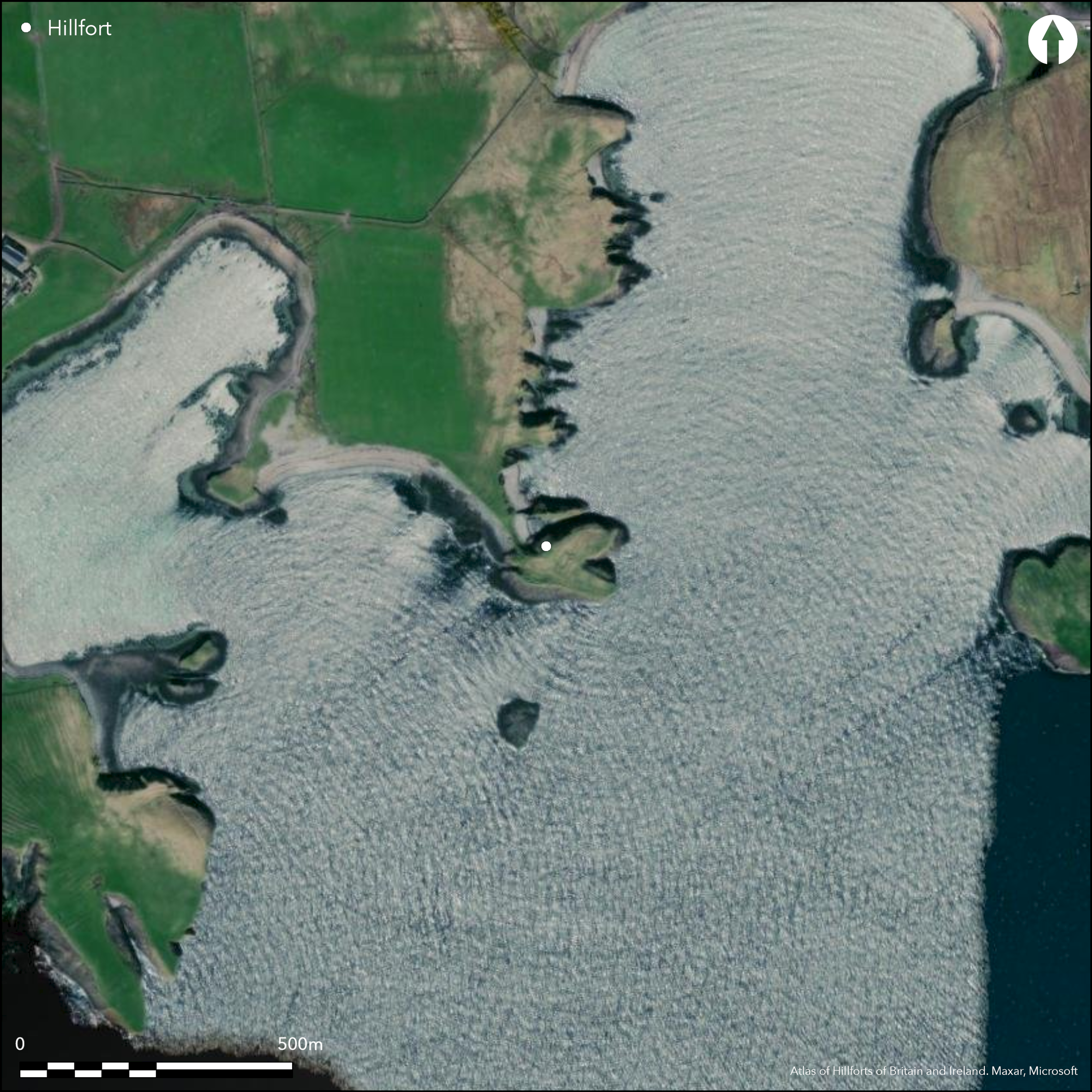
This fortification occupies a large heart-shaped promontory forming the E side of Holm Bay, and is connected on the NW to the shore by no more than a narrow ridge of eroded till rising above the beaches to either side. The promontory is girt with cliffs all along its N and E flanks, though on the S a grass-grown slope gives way to a broad expanse of eroded outcrops. The scale of the defences is unclear, for there is little sign of a stone wall where the ground rises up from the neck, though there is evidently a thick bank extending along the lip of the promontory on this flank and round onto the S; the slope below the bank along the S side is studded with stones, but exposures of the core of the bank at the W tip and on the NW indicate that it is largely earthen, and, unusually for a promontory fort, it can be traced around most of the margin. The area enclosed describes a V on plan, with its apex on the W, and measures 92m in length both from NE to SW along its northern arm, and from E to W along its southern arm (0.3ha). It is largely occupied however by the grass-grown footings of a series of rectangular buildings, at least one of which has been a very substantial structure, and also a series of associated enclosures. The impression is that perhaps this is in its present configuration not a prehistoric fort, but rather a medieval or post-medieval stronghold.
Citizen Science: ✗
Reliability of Data: Confirmed
Reliability of Interpretation: Confirmed
X: -704963 Y: 8007525 (EPSG: 3857)
Longitude: -6.332791386992203 Latitude: 58.19089247802701 (EPSG:4326)
Country: Scotland
Current County or Unitary Authority: Western Isles
Historic County: Ross-shire
Current Parish/Community/Council/Townland: Stornoway
None
| Extant | ✓ |
| Cropmark | ✗ |
| Likely Destroyed | ✗ |
None
| Woodland | ✗ |
| Commercial Forestry Plantation | ✗ |
| Parkland | ✗ |
| Pasture (Grazing) | ✓ |
| Arable | ✗ |
| Scrub/Bracken | ✗ |
| Bare Outcrop | ✗ |
| Heather/Moorland | ✗ |
| Heath | ✗ |
| Built-up | ✗ |
| Coastal Grassland | ✓ |
| Other | ✗ |
None
| Contour Fort | ✗ |
| Partial Contour Fort | ✗ |
| Promontory Fort | ✓ |
| Hillslope Fort | ✗ |
| Level Terrain Fort | ✗ |
| Marsh Fort | ✗ |
| Multiple Enclosure Fort | ✗ |
| Hilltop | ✗ |
| Coastal Promontory | ✓ |
| Inland Promontory | ✗ |
| Valley Bottom | ✗ |
| Knoll/Hillock/Outcrop | ✗ |
| Ridge | ✗ |
| Cliff/Plateau-edge/Scarp | ✗ |
| Hillslope | ✗ |
| Lowland | ✗ |
| Spur | ✗ |
Dominant Topographic Feature: None
| North | ✗ |
| Northeast | ✗ |
| East | ✗ |
| Southeast | ✗ |
| South | ✗ |
| Southwest | ✗ |
| West | ✗ |
| Northwest | ✗ |
| Level | ✓ |
Altitude: 15.0m
N/A
In the absence of excavation, there are neither stratified artefacts nor radiocarbon dates to provide a chronology for the defences.
Reliability: D - None
| Pre 1200BC | ✗ |
| 1200BC - 800BC | ✗ |
| 800BC - 400BC | ✗ |
| 400BC - AD50 | ✗ |
| AD50 - AD400 | ✗ |
| AD400 - AD 800 | ✗ |
| Post AD800 | ✓ |
| Unknown | ✓ |
| Pre Hillfort: | None |
| Post Hillfort: | If there is a fort here it is overlain by later rectangular buildings. |
Photographed from the air in 1980, and by RCAHMS Aerial Survey Programme in 2004
| 1st Identified Written Reference (1914): | Description (RCAHMS 1928, 14, no.46) |
| 1st Identified Map Depiction (1964): | Visited by the OS |
| Earthwork Survey (1992): | description and possibly a drawn plan but unseen by SH (Cunningham and Hothersall 1992) |
| Other (1992): | Scheduled |
| Other (2014): | Description and photographs by S Halliday |
Occupied by rectangular buildings and enclosures
None
| None | ✓ |
| Spring | ✗ |
| Stream | ✗ |
| Pool | ✗ |
| Flush | ✗ |
| Well | ✗ |
| Other | ✗ |
None
| No Known Features | ✗ |
| Round Stone Structures | ✗ |
| Rectangular Stone Structures | ✓ |
| Curvilinear Platforms | ✗ |
| Other Roundhouse Evidence | ✗ |
| Pits | ✗ |
| Quarry Hollows | ✗ |
| Other | ✗ |
None
| No Known Excavation | ✓ |
| Pits | ✗ |
| Postholes | ✗ |
| Roundhouses | ✗ |
| Rectangular Structures | ✗ |
| Roads/Tracks | ✗ |
| Quarry Hollows | ✗ |
| Other | ✗ |
| Nothing Found | ✗ |
None
| No Known Geophysics | ✓ |
| Pits | ✗ |
| Roundhouses | ✗ |
| Rectangular Structures | ✗ |
| Roads/Tracks | ✗ |
| Quarry Hollows | ✗ |
| Other | ✗ |
| Nothing Found | ✗ |
None
| No Known Finds | ✓ |
| Pottery | ✗ |
| Metal | ✗ |
| Metalworking | ✗ |
| Human Bones | ✗ |
| Animal Bones | ✗ |
| Lithics | ✗ |
| Environmental | ✗ |
| Other | ✗ |
None
| APs Not Checked | ✗ |
| None | ✗ |
| Roundhouses | ✗ |
| Rectangular Structures | ✓ |
| Pits | ✗ |
| Postholes | ✗ |
| Roads/Tracks | ✗ |
| Other | ✗ |
See main summary
| 2: | None |
| 2: | Not certainly visible, but probably at the W tip |
Guard Chambers: ✗
Chevaux de Frise: ✗
Single bank
| Area 1: | 0.3ha. |
| Total: | 0.3ha. |
Total Footprint Area: Noneha.
None
| ✗ | None |
| ✓ | None |
| NE Quadrant: | 1 |
| SE Quadrant: | 1 |
| SW Quadrant: | 1 |
| NW Quadrant: | 1 |
| Total: | 1 |
| Partial Univallate | ✗ |
| Univallate | ✓ |
| Partial Bivallate | ✗ |
| Bivallate | ✗ |
| Partial Multivallate | ✗ |
| Multivallate | ✗ |
| Unknown | ✗ |
| Partial Univallate | ✗ |
| Univallate | ✗ |
| Partial Bivallate | ✗ |
| Bivallate | ✗ |
| Partial Multivallate | ✗ |
| Multivallate | ✗ |
None
| None | ✗ |
| Earthen Bank | ✓ |
| Stone Wall | ✗ |
| Rubble | ✗ |
| Wall-walk | ✗ |
| Evidence of Timber | ✗ |
| Vitrification | ✗ |
| Other Burning | ✗ |
| Palisade | ✗ |
| Counter Scarp Bank | ✗ |
| Berm | ✗ |
| Unfinished | ✗ |
| Other | ✗ |
None
| None | ✗ |
| Earthen Bank | ✗ |
| Stone Wall | ✗ |
| Murus Duplex | ✗ |
| Timber-framed | ✗ |
| Timber-laced | ✗ |
| Vitrification | ✗ |
| Other Burning | ✗ |
| Palisade | ✗ |
| Counter Scarp Bank | ✗ |
| Berm | ✗ |
| Unfinished | ✗ |
| No Known Excavation | ✓ |
| Other | ✗ |
| ✗ | None |
| ✗ | None |
Number of Ditches: None
| ✗ | None |
Cunningham and Hothersall, C M and S (1992) 'Rubdha Shilldinish, Holm (Stornoway parish): survey of promontory site'. Disc Exc Scot (1992), 84
RCAHMS (1928) The Royal Commission on the Ancient and Historical Monuments and Constructions of Scotland. Ninth report with inventory of monuments and constructions in the Outer Hebrides, Skye and the Small Isles. HMSO: Edinburgh
Atlas of Hillforts:
Wikidata:
This work is licensed under CC BY-SA 4.0![]()
![]()
![]() and should be cited as:
and should be cited as:
Lock, Gary and Ralston, Ian. 2024. Atlas of Hillforts of Britain and Ireland. Available at: https://hillforts.arch.ox.ac.uk
Document Version 1.1