Satellite Imagery
Satellite Imagery
HER: Highland HER MHG12221 (None)
NMR: NC 03 SW 1 (4519)
SM: None
NGR: NC 0419 3400
X: 204190 Y: 934000 (OSGB36)
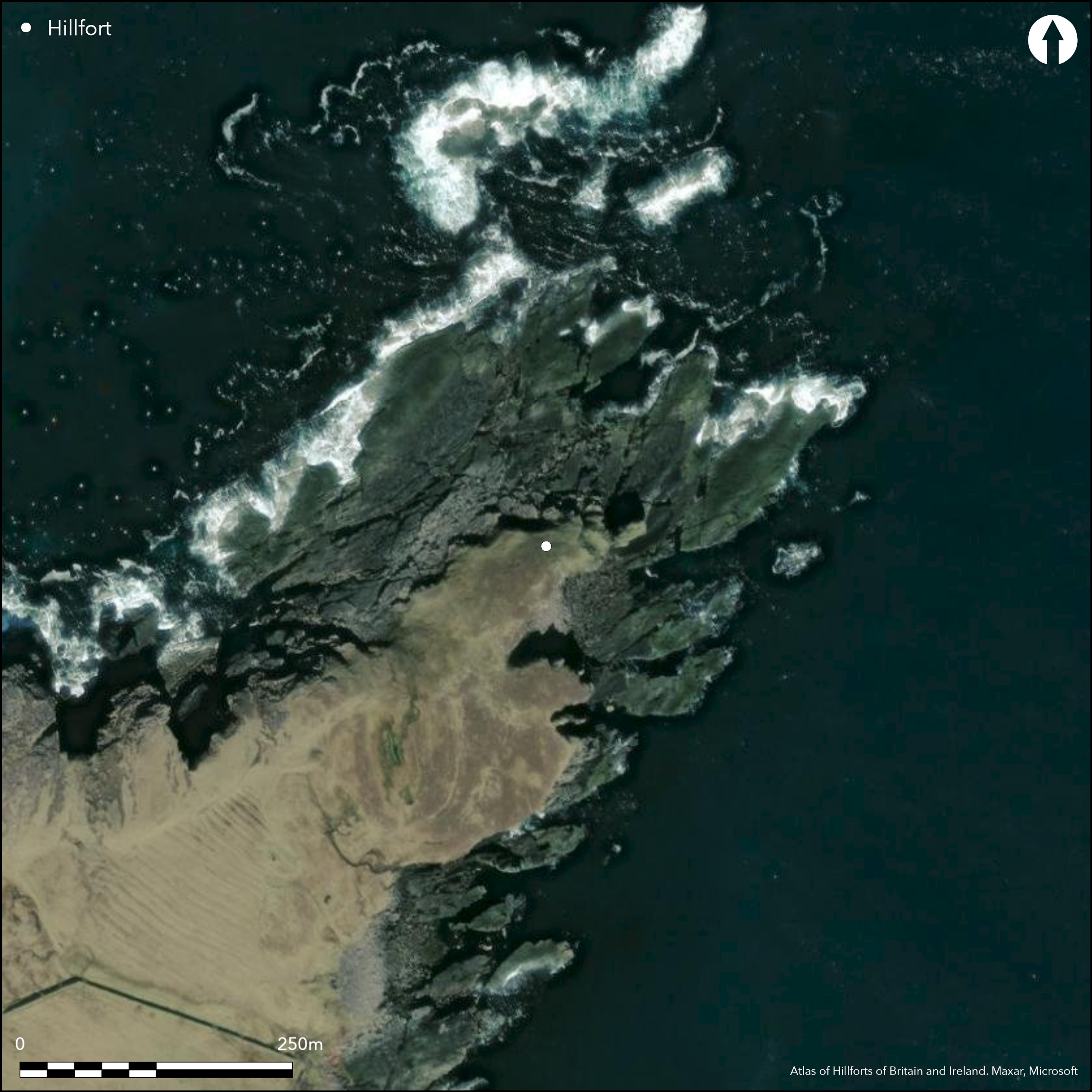
A complex promontory fortification is situated on the headland named Rubh'an Dunain, which forms the NW shore of the Bay of Culkein. The promontory terminates on the NE in a stack that is joined to the mainland by no more than a narrow bridge of outcrop spanning a chasm falling about 15m to a broad wave-cut platform at the foot of the cliffs. The principal elements of the defences comprise a rectilinear block occupying the landward end of the stack above the bridge, with an outer wall drawn across the promontory to block access to the landward end of the bridge; in addition, a much slighter wall cuts across the spine of the promontory a little over 20m further to the W. The summit of the stack measures about 15m from ENE to WSW by 6m transversely and the whole of the western half is occupied by a rectangular structure measuring about 7m in length by 5m in breadth, which still displays the masonry of its battered outer face standing about 1m high in four course in its N side; there are also traces of a wall-face extending along the N margin of the rest of the stack. The main defence on the landward side is a wall between 2.3 and 3m thick, constructed with massive blocks and in places still standing about 1m high; there are also possible traces of face within the thickness of the wall. Drawn in an arc across the crest of the promontory and returning along its N margin, it is broken by an unchecked entrance on the WSW close to the cliff-edge and encloses an area measuring about 10m from NW to SE by 8m transversely. The slighter outer wall, which is also broken by a gap near the cliff-edge on the SE margin of the promontory, encloses an additional area of about 0.05ha.
Citizen Science: ✗
Reliability of Data: Confirmed
Reliability of Interpretation: Confirmed
X: -594284 Y: 8020250 (EPSG: 3857)
Longitude: -5.338546213830781 Latitude: 58.25109106193789 (EPSG:4326)
Country: Scotland
Current County or Unitary Authority: Highland
Historic County: Sutherland
Current Parish/Community/Council/Townland: Assynt
None
| Extant | ✓ |
| Cropmark | ✗ |
| Likely Destroyed | ✗ |
None
| Woodland | ✗ |
| Commercial Forestry Plantation | ✗ |
| Parkland | ✗ |
| Pasture (Grazing) | ✓ |
| Arable | ✗ |
| Scrub/Bracken | ✗ |
| Bare Outcrop | ✗ |
| Heather/Moorland | ✗ |
| Heath | ✗ |
| Built-up | ✗ |
| Coastal Grassland | ✓ |
| Other | ✗ |
None
| Contour Fort | ✗ |
| Partial Contour Fort | ✗ |
| Promontory Fort | ✓ |
| Hillslope Fort | ✗ |
| Level Terrain Fort | ✗ |
| Marsh Fort | ✗ |
| Multiple Enclosure Fort | ✗ |
| Hilltop | ✗ |
| Coastal Promontory | ✓ |
| Inland Promontory | ✗ |
| Valley Bottom | ✗ |
| Knoll/Hillock/Outcrop | ✗ |
| Ridge | ✗ |
| Cliff/Plateau-edge/Scarp | ✗ |
| Hillslope | ✗ |
| Lowland | ✗ |
| Spur | ✗ |
Dominant Topographic Feature: None
| North | ✗ |
| Northeast | ✗ |
| East | ✗ |
| Southeast | ✗ |
| South | ✗ |
| Southwest | ✗ |
| West | ✗ |
| Northwest | ✗ |
| Level | ✓ |
Altitude: 15.0m
N/A
In the absence of excavation, there are neither stratified artefacts nor radiocarbon dates to provide a chronology for the defences.
Reliability: D - None
| Pre 1200BC | ✗ |
| 1200BC - 800BC | ✗ |
| 800BC - 400BC | ✗ |
| 400BC - AD50 | ✗ |
| AD50 - AD400 | ✗ |
| AD400 - AD 800 | ✗ |
| Post AD800 | ✗ |
| Unknown | ✓ |
| Pre Hillfort: | None |
| Post Hillfort: | None |
Photographed by RCAHMS Aerial Survey Programme in 2010. Highland HER also holds ground views
| 1st Identified Map Depiction (1875): | Named in Gothic type and annotated '(Pictish)' on the 1st edition OS 6-inch map (Sutherland 1878, sheet 48) |
| Other (1909): | Description (RCAHMS 1911, 2, no.6) |
| Earthwork Survey (2008): | Plan and description by Gordon Sleight, Historic Assynt for RCAHMS SRP project |
Featureless
None
| None | ✓ |
| Spring | ✗ |
| Stream | ✗ |
| Pool | ✗ |
| Flush | ✗ |
| Well | ✗ |
| Other | ✗ |
None
| No Known Features | ✓ |
| Round Stone Structures | ✗ |
| Rectangular Stone Structures | ✗ |
| Curvilinear Platforms | ✗ |
| Other Roundhouse Evidence | ✗ |
| Pits | ✗ |
| Quarry Hollows | ✗ |
| Other | ✗ |
None
| No Known Excavation | ✓ |
| Pits | ✗ |
| Postholes | ✗ |
| Roundhouses | ✗ |
| Rectangular Structures | ✗ |
| Roads/Tracks | ✗ |
| Quarry Hollows | ✗ |
| Other | ✗ |
| Nothing Found | ✗ |
None
| No Known Geophysics | ✓ |
| Pits | ✗ |
| Roundhouses | ✗ |
| Rectangular Structures | ✗ |
| Roads/Tracks | ✗ |
| Quarry Hollows | ✗ |
| Other | ✗ |
| Nothing Found | ✗ |
None
| No Known Finds | ✓ |
| Pottery | ✗ |
| Metal | ✗ |
| Metalworking | ✗ |
| Human Bones | ✗ |
| Animal Bones | ✗ |
| Lithics | ✗ |
| Environmental | ✗ |
| Other | ✗ |
NO APPARENT FEATURES
| APs Not Checked | ✗ |
| None | ✓ |
| Roundhouses | ✗ |
| Rectangular Structures | ✗ |
| Pits | ✗ |
| Postholes | ✗ |
| Roads/Tracks | ✗ |
| Other | ✗ |
See main summary
| 1: | None |
| 2: | None |
Guard Chambers: ✗
Chevaux de Frise: ✗
| 1. Simple Gap (South west): | In outer walls |
Blockhouse on the stack and a thick wall across the promontory, with thin outer wall further out
| Area 1: | 0.02ha. |
| Total: | 0.02ha. |
Total Footprint Area: 0.1ha.
None
| ✗ | Overall extent measured to outer wall |
| ✗ | Includes the block-house wall but excludes the outermost line, which though it turns back as if to enclose the promontory on its SE flank, may yet prove to be a more recent addition. |
| NE Quadrant: | 0 |
| SE Quadrant: | 0 |
| SW Quadrant: | 2 |
| NW Quadrant: | 1 |
| Total: | 2 |
| Partial Univallate | ✓ |
| Univallate | ✗ |
| Partial Bivallate | ✓ |
| Bivallate | ✗ |
| Partial Multivallate | ✗ |
| Multivallate | ✗ |
| Unknown | ✗ |
| Partial Univallate | ✗ |
| Univallate | ✗ |
| Partial Bivallate | ✗ |
| Bivallate | ✗ |
| Partial Multivallate | ✗ |
| Multivallate | ✗ |
None
| None | ✗ |
| Earthen Bank | ✗ |
| Stone Wall | ✓ |
| Rubble | ✗ |
| Wall-walk | ✗ |
| Evidence of Timber | ✗ |
| Vitrification | ✗ |
| Other Burning | ✗ |
| Palisade | ✗ |
| Counter Scarp Bank | ✗ |
| Berm | ✗ |
| Unfinished | ✗ |
| Other | ✗ |
None
| None | ✗ |
| Earthen Bank | ✗ |
| Stone Wall | ✗ |
| Murus Duplex | ✗ |
| Timber-framed | ✗ |
| Timber-laced | ✗ |
| Vitrification | ✗ |
| Other Burning | ✗ |
| Palisade | ✗ |
| Counter Scarp Bank | ✗ |
| Berm | ✗ |
| Unfinished | ✗ |
| No Known Excavation | ✓ |
| Other | ✗ |
| ✗ | None |
| ✗ | None |
Number of Ditches: None
| ✓ | Slight outer wall cutting across the promontory might be regarded as an annexe, doubling the size of the enclosed area. |
Feachem, R (1963) A guide to prehistoric Scotland. Batsford: London (p 159)
RCAHMS (1911) The Royal Commission on the Ancient and Historical Monuments and Constructions of Scotland. Second report and inventory of monuments and constructions in the county of Sutherland. HMSO: Edinburgh
Atlas of Hillforts:
Wikidata:
This work is licensed under CC BY-SA 4.0![]()
![]()
![]() and should be cited as:
and should be cited as:
Lock, Gary and Ralston, Ian. 2024. Atlas of Hillforts of Britain and Ireland. Available at: https://hillforts.arch.ox.ac.uk
Document Version 1.1