Satellite Imagery
Satellite Imagery
HER: Highland HER MHG9658 (None)
NMR: NC 84 SW 1 (6792)
SM: 1836
NGR: NC 8309 4116
X: 283091 Y: 941169 (OSGB36)
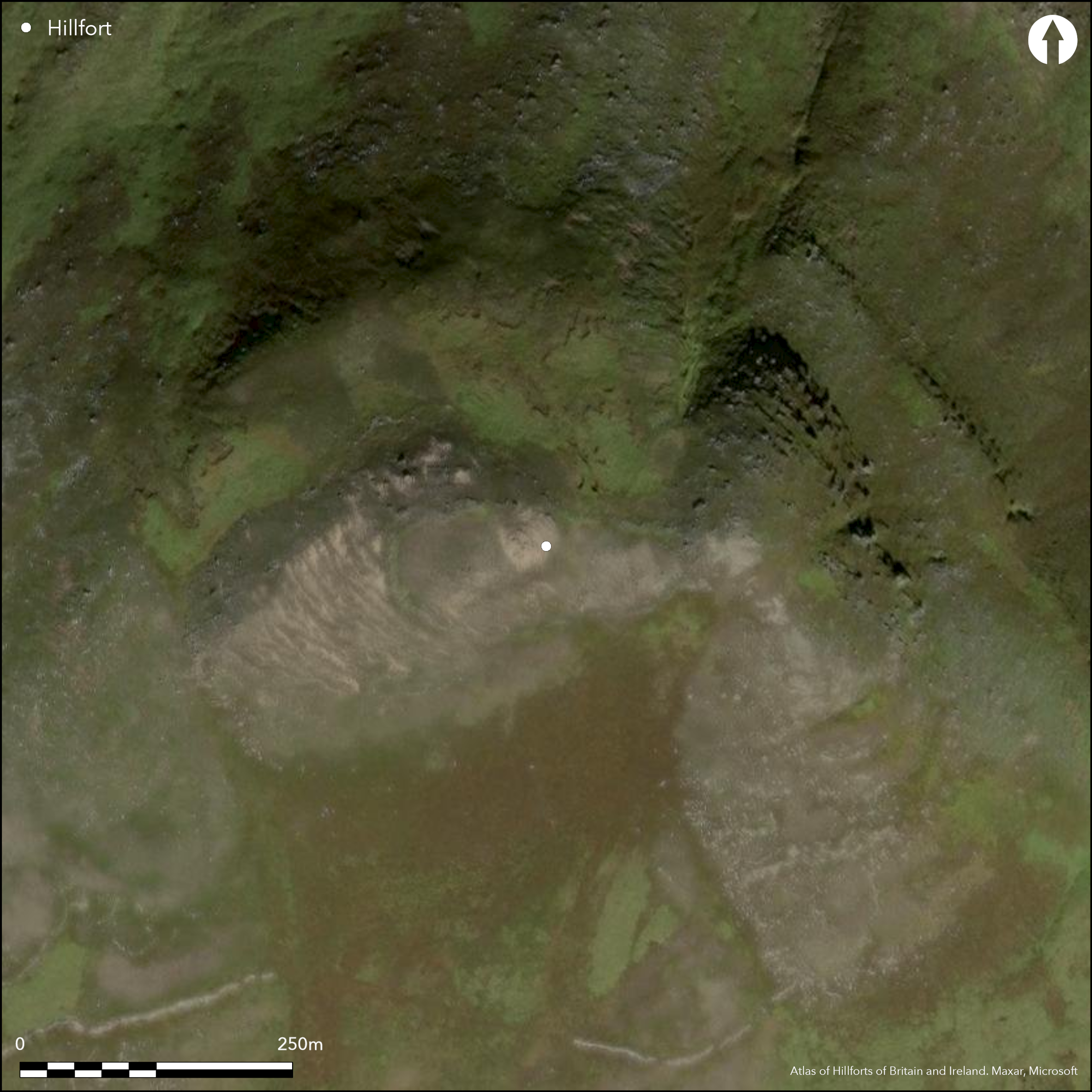
The fortifications on Ben Griam Beg are remarkable for several reasons, amongst them being that at 580m OD they are the highest of any in Scotland, and are indeed amongst the most remote. The principle enclosure that can be seen extends from the foot of the summit boss westwards along the ridge enclosing an oval area measuring about 140m from E to W by 60m transversely (0.67ha) within a wall typically about 1.5m in thickness, but in places up to 2.5m. Eastwards the wall peters out on the edge of the rocky margin of the hill's SE spur, and though there is one short length of wall blocking a gully on the SW flank, and another on the crest 50m SE of the OS triangulation station, it is unclear to what extent this area was taken into the circuit; if these walls form elements of the circuit the overall area of this inner enclosure might have extended to as much as 1ha, while to the edge of the crags on the SE is an additional 0.11ha. Parts of the interior are covered in peat, while across large areas it is bare rock or strewn with stones, but midway along the S side there is at least one possible hut-circle. At least three entrances can be seen, two in the N side and one towards the E end of the S side, while a second gap in this side a little further to the W is thought to be more recent. In addition to this enclosure there are at least two annexes apparently springing from its perimeter on the N (0.3ha) and W (0.95ha), though their perimeters are constructed on a much slighter scale and there is no reason to regard them as part of a defensive scheme. Extending across the S flank of the hill for a distance of about 500m, however, between 90m and 120m lower down the slope, there is another monumental wall built with huge slabs and still standing up to 2m high. Its W end rests close to the rib of outcrop forming the crag known as Creag an Iolaire (the Eagle's Crag), while to the E it peters out amongst a cluster of small enclosures close to the lip of the steep and rocky E flank of the hill; its line is broken by numerous gaps that appear to be original. The cluster of enclosures noted at its E end is one of several around the S and and W flanks of the hill which seem to be made up of small plots or pounds, clearance heaps and possible hut-circles; elements of those on the S appear to have been cleared to build the huge wall across this flank.
Citizen Science: ✓
Reliability of Data: Confirmed
Reliability of Interpretation: Confirmed
X: -445149 Y: 8039822 (EPSG: 3857)
Longitude: -3.9988415669872723 Latitude: 58.34348555606707 (EPSG:4326)
Country: Scotland
Current County or Unitary Authority: Highland
Historic County: Sutherland
Current Parish/Community/Council/Townland: Farr
None
| Extant | ✓ |
| Cropmark | ✗ |
| Likely Destroyed | ✗ |
None
| Woodland | ✗ |
| Commercial Forestry Plantation | ✗ |
| Parkland | ✗ |
| Pasture (Grazing) | ✗ |
| Arable | ✗ |
| Scrub/Bracken | ✗ |
| Bare Outcrop | ✗ |
| Heather/Moorland | ✓ |
| Heath | ✗ |
| Built-up | ✗ |
| Coastal Grassland | ✗ |
| Other | ✗ |
None
| Contour Fort | ✓ |
| Partial Contour Fort | ✗ |
| Promontory Fort | ✗ |
| Hillslope Fort | ✗ |
| Level Terrain Fort | ✗ |
| Marsh Fort | ✗ |
| Multiple Enclosure Fort | ✓ |
| Hilltop | ✓ |
| Coastal Promontory | ✗ |
| Inland Promontory | ✗ |
| Valley Bottom | ✗ |
| Knoll/Hillock/Outcrop | ✗ |
| Ridge | ✗ |
| Cliff/Plateau-edge/Scarp | ✗ |
| Hillslope | ✗ |
| Lowland | ✗ |
| Spur | ✗ |
Dominant Topographic Feature: None
| North | ✗ |
| Northeast | ✗ |
| East | ✗ |
| Southeast | ✗ |
| South | ✗ |
| Southwest | ✗ |
| West | ✗ |
| Northwest | ✗ |
| Level | ✓ |
Altitude: 580.0m
N/A
In the absence of excavation, there are neither stratified artefacts nor radiocarbon dates to provide a chronology for the defences.
Reliability: D - None
| Pre 1200BC | ✗ |
| 1200BC - 800BC | ✗ |
| 800BC - 400BC | ✗ |
| 400BC - AD50 | ✗ |
| AD50 - AD400 | ✗ |
| AD400 - AD 800 | ✗ |
| Post AD800 | ✗ |
| Unknown | ✗ |
| Pre Hillfort: | None |
| Post Hillfort: | None |
None
| 1st Identified Map Depiction (1873): | Annotated 'Supposed Remains of Fort' on the 1st edition OS 6-inch map (Sutherland 1878, sheet 46) |
| Other (1909): | Description |
| Other (1934): | Scheduled |
| Other (1960): | Visited by the OS |
| Other (1977): | Visited by the OS |
| Other (1982): | Description (Ralston and Smith 1983) |
| Earthwork Survey (1988): | Plan and description (Mercer 1991) |
| Other (1997): | Visited by the Hill-Fort Study Group |
At least one hut-circle
None
| None | ✓ |
| Spring | ✗ |
| Stream | ✗ |
| Pool | ✗ |
| Flush | ✗ |
| Well | ✗ |
| Other | ✗ |
None
| No Known Features | ✗ |
| Round Stone Structures | ✓ |
| Rectangular Stone Structures | ✗ |
| Curvilinear Platforms | ✗ |
| Other Roundhouse Evidence | ✗ |
| Pits | ✗ |
| Quarry Hollows | ✗ |
| Other | ✗ |
None
| No Known Excavation | ✓ |
| Pits | ✗ |
| Postholes | ✗ |
| Roundhouses | ✗ |
| Rectangular Structures | ✗ |
| Roads/Tracks | ✗ |
| Quarry Hollows | ✗ |
| Other | ✗ |
| Nothing Found | ✗ |
None
| No Known Geophysics | ✓ |
| Pits | ✗ |
| Roundhouses | ✗ |
| Rectangular Structures | ✗ |
| Roads/Tracks | ✗ |
| Quarry Hollows | ✗ |
| Other | ✗ |
| Nothing Found | ✗ |
None
| No Known Finds | ✓ |
| Pottery | ✗ |
| Metal | ✗ |
| Metalworking | ✗ |
| Human Bones | ✗ |
| Animal Bones | ✗ |
| Lithics | ✗ |
| Environmental | ✗ |
| Other | ✗ |
NO APPARENT FEATURES
| APs Not Checked | ✓ |
| None | ✗ |
| Roundhouses | ✗ |
| Rectangular Structures | ✗ |
| Pits | ✗ |
| Postholes | ✗ |
| Roads/Tracks | ✗ |
| Other | ✗ |
See main summary
| 4: | None |
| 2: | None |
Guard Chambers: ✗
Chevaux de Frise: ✗
| 1. Simple Gap (South east): | None |
| 2. Simple Gap (North west): | None |
| 3. Simple Gap (North): | None |
Single wall with annexes on the N and W and a major outlying wall to the S
| Area 1: | 1.0ha. |
| Area 2: | 2.3ha. |
| Total: | 2.3ha. |
Total Footprint Area: 2.3ha.
None
| ✗ | This does not include the outlying wall to the S |
| ✗ | The inner enclosure is tabulated below |
| NE Quadrant: | 0 |
| SE Quadrant: | 1 |
| SW Quadrant: | 1 |
| NW Quadrant: | 1 |
| Total: | 1 |
| Partial Univallate | ✓ |
| Univallate | ✗ |
| Partial Bivallate | ✗ |
| Bivallate | ✗ |
| Partial Multivallate | ✗ |
| Multivallate | ✗ |
| Unknown | ✗ |
| Partial Univallate | ✗ |
| Univallate | ✗ |
| Partial Bivallate | ✗ |
| Bivallate | ✗ |
| Partial Multivallate | ✗ |
| Multivallate | ✗ |
Faced with upright slabs
| None | ✗ |
| Earthen Bank | ✗ |
| Stone Wall | ✓ |
| Rubble | ✗ |
| Wall-walk | ✗ |
| Evidence of Timber | ✗ |
| Vitrification | ✗ |
| Other Burning | ✗ |
| Palisade | ✗ |
| Counter Scarp Bank | ✗ |
| Berm | ✗ |
| Unfinished | ✗ |
| Other | ✗ |
None
| None | ✗ |
| Earthen Bank | ✗ |
| Stone Wall | ✗ |
| Murus Duplex | ✗ |
| Timber-framed | ✗ |
| Timber-laced | ✗ |
| Vitrification | ✗ |
| Other Burning | ✗ |
| Palisade | ✗ |
| Counter Scarp Bank | ✗ |
| Berm | ✗ |
| Unfinished | ✗ |
| No Known Excavation | ✓ |
| Other | ✗ |
| ✗ | None |
| ✗ | None |
Number of Ditches: None
| ✓ | At least two annexes on the N (0.3ha) and W (0.95ha), but of unknown relationship to the enclosure on the crest of the ridge. |
Feachem, R (1963) A guide to prehistoric Scotland. Batsford: London (p 158)
Mercer, R (1991) 'The survey of a hilltop enclosure on Ben Griam Beg, Caithness and Sutherland District, Highland Region'. 140- 52 in Hanson, W S and Slater, E A eds (1991) Scottish Archaeology; New Perceptions. AUP: Aberdeen
RCAHMS (1911) The Royal Commission on the Ancient and Historical Monuments and Constructions of Scotland. Second report and inventory of monuments and constructions in the county of Sutherland. HMSO: Edinburgh
Ralston and Smith, I and J S (1982) 'Ben Griam Beg (Kildonan p) fort, settlement'. Disc Exc Scot (1982), 16
Ralston and Smith, I and J S (1983) 'High altitude settlement on Ben Griam Beg, Sutherland'. Proc Soc Antiq Scot 113 (1983), 636-8
Atlas of Hillforts:
Wikidata:
This work is licensed under CC BY-SA 4.0![]()
![]()
![]() and should be cited as:
and should be cited as:
Lock, Gary and Ralston, Ian. 2024. Atlas of Hillforts of Britain and Ireland. Available at: https://hillforts.arch.ox.ac.uk
Document Version 1.1