Satellite Imagery
Satellite Imagery
HER: Highland HER MHG43243 (None)
NMR: NC 86 NE 1 (6840)
SM: None
NGR: NC 8535 6635
X: 285350 Y: 966350 (OSGB36)
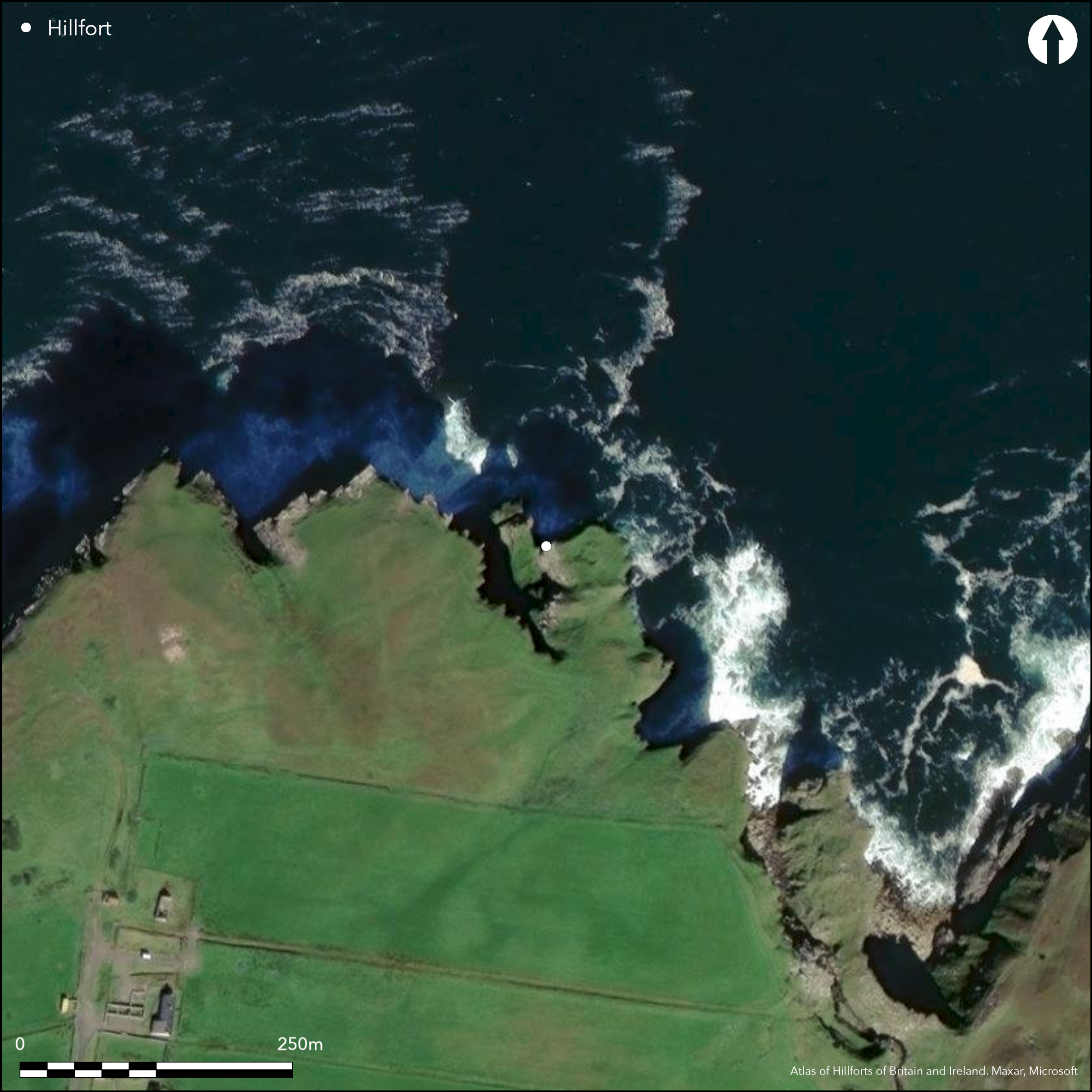
The remains of this small fortification are situated on a precipitous coastal promontory NE of Baligill. Its defences probably represent at least two periods of construction, the earlier comprising a thick upcast rampart with an external ditch blocking all access to the promontory along the cliff-line from the S. This appears to be overlain at a slight angle by a wall about 4.2m thick, the combined height of the wall and underlying rampart being in the order of 1.8m. A central entrance passage, possibly with an upright slab representing a door-check surviving in place on its E side, opens onto a causeway across the broad and irregular ditch, which may have been dug out from a natural gully. The interior measures about 27m from NW to SE by 25m transversely (0.07ha), and while there are traces of minor walls extending along its flanks, for the most part it falls sheer into the sea. Roughly at the centre of the interior a rectangular building with orthostatic walls can be seen, also appearing as an open rectangle on the 1st edition of the OS 6-inch map (Sutherland 1878, sheet 10), but on its NW, seaward, side there are traces of a heavily disturbed stone structure, with a passage or souterrain extending ENE to emerge on the cliff-face.
Citizen Science: ✗
Reliability of Data: Confirmed
Reliability of Interpretation: Confirmed
X: -442261 Y: 8088045 (EPSG: 3857)
Longitude: -3.9728973708773494 Latitude: 58.57010767292424 (EPSG:4326)
Country: Scotland
Current County or Unitary Authority: Highland
Historic County: Sutherland
Current Parish/Community/Council/Townland: Farr
None
| Extant | ✓ |
| Cropmark | ✗ |
| Likely Destroyed | ✗ |
None
| Woodland | ✗ |
| Commercial Forestry Plantation | ✗ |
| Parkland | ✗ |
| Pasture (Grazing) | ✓ |
| Arable | ✗ |
| Scrub/Bracken | ✗ |
| Bare Outcrop | ✗ |
| Heather/Moorland | ✓ |
| Heath | ✗ |
| Built-up | ✗ |
| Coastal Grassland | ✓ |
| Other | ✗ |
None
| Contour Fort | ✗ |
| Partial Contour Fort | ✗ |
| Promontory Fort | ✓ |
| Hillslope Fort | ✗ |
| Level Terrain Fort | ✗ |
| Marsh Fort | ✗ |
| Multiple Enclosure Fort | ✗ |
| Hilltop | ✗ |
| Coastal Promontory | ✓ |
| Inland Promontory | ✗ |
| Valley Bottom | ✗ |
| Knoll/Hillock/Outcrop | ✗ |
| Ridge | ✗ |
| Cliff/Plateau-edge/Scarp | ✗ |
| Hillslope | ✗ |
| Lowland | ✗ |
| Spur | ✗ |
Dominant Topographic Feature: None
| North | ✗ |
| Northeast | ✗ |
| East | ✗ |
| Southeast | ✗ |
| South | ✗ |
| Southwest | ✗ |
| West | ✗ |
| Northwest | ✗ |
| Level | ✓ |
Altitude: 25.0m
N/A
In the absence of excavation, there are neither stratified artefacts nor radiocarbon dates to provide a chronology for the defences.
Reliability: D - None
| Pre 1200BC | ✗ |
| 1200BC - 800BC | ✗ |
| 800BC - 400BC | ✗ |
| 400BC - AD50 | ✗ |
| AD50 - AD400 | ✗ |
| AD400 - AD 800 | ✗ |
| Post AD800 | ✗ |
| Unknown | ✗ |
| Pre Hillfort: | None |
| Post Hillfort: | None |
The RCAHMS collection contains one ground view, while the Highland HER holds an extensive photographic archive
| 1st Identified Map Depiction (1873): | Named in Gothic type on the 1st edition OS 6-inch map (Sutherland 1878, sheet 10) |
| Other (1909): | Description (RCAHMS 1911, 129, no.191) |
| Other (1960): | Visited by the OS |
| Other (1971): | Description and sketch-plan by Raymond Lamb (1980, 24 fig 9, 72) |
| Other (1972): | Visited by the OS |
| Earthwork Survey (1977): | Visited by the OS; surveyed at 1:625 by John Barneville |
| Earthwork Survey (1980): | Plan and description by R J Mercer (1981, 129, fig 28; RCAHMS SUD 107/170 & SUD 107/58) |
| Other (1997): | Visited by the Hill-Fort Study Group |
| Earthwork Survey (2004): | Plan and description by J E Kirby in Highland HER (the N point appears to be skewed ) |
A rectangular building and traces of other stone structures with a souterrain
None
| None | ✓ |
| Spring | ✗ |
| Stream | ✗ |
| Pool | ✗ |
| Flush | ✗ |
| Well | ✗ |
| Other | ✗ |
Souterrain
| No Known Features | ✗ |
| Round Stone Structures | ✗ |
| Rectangular Stone Structures | ✓ |
| Curvilinear Platforms | ✗ |
| Other Roundhouse Evidence | ✗ |
| Pits | ✗ |
| Quarry Hollows | ✗ |
| Other | ✓ |
None
| No Known Excavation | ✓ |
| Pits | ✗ |
| Postholes | ✗ |
| Roundhouses | ✗ |
| Rectangular Structures | ✗ |
| Roads/Tracks | ✗ |
| Quarry Hollows | ✗ |
| Other | ✗ |
| Nothing Found | ✗ |
None
| No Known Geophysics | ✓ |
| Pits | ✗ |
| Roundhouses | ✗ |
| Rectangular Structures | ✗ |
| Roads/Tracks | ✗ |
| Quarry Hollows | ✗ |
| Other | ✗ |
| Nothing Found | ✗ |
None
| No Known Finds | ✓ |
| Pottery | ✗ |
| Metal | ✗ |
| Metalworking | ✗ |
| Human Bones | ✗ |
| Animal Bones | ✗ |
| Lithics | ✗ |
| Environmental | ✗ |
| Other | ✗ |
NO APPARENT FEATURES
| APs Not Checked | ✗ |
| None | ✓ |
| Roundhouses | ✗ |
| Rectangular Structures | ✗ |
| Pits | ✗ |
| Postholes | ✗ |
| Roads/Tracks | ✗ |
| Other | ✗ |
See main summary
| 1: | None |
| 2: | None |
Guard Chambers: ✗
Chevaux de Frise: ✗
| 1. Simple Gap (South): | Upright slab is possibly a door-check |
Single bank and ditch cutting off promontory, but with a thick stone rampart lying at a slight angle to it, which has been compared with blockhouse architecture
| Area 1: | 0.07ha. |
| Total: | 0.07ha. |
Total Footprint Area: Noneha.
None
| ✓ | None |
| ✗ | None |
| NE Quadrant: | 0 |
| SE Quadrant: | 1 |
| SW Quadrant: | 0 |
| NW Quadrant: | 0 |
| Total: | 1 |
| Partial Univallate | ✓ |
| Univallate | ✗ |
| Partial Bivallate | ✗ |
| Bivallate | ✗ |
| Partial Multivallate | ✗ |
| Multivallate | ✗ |
| Unknown | ✗ |
| Partial Univallate | ✗ |
| Univallate | ✗ |
| Partial Bivallate | ✗ |
| Bivallate | ✗ |
| Partial Multivallate | ✗ |
| Multivallate | ✗ |
The thickness of the wall across the neck has led to led to comparisons with block-house architecture (Lamb 1980, 21, 24-6, 35, 40, 72)
| None | ✗ |
| Earthen Bank | ✓ |
| Stone Wall | ✓ |
| Rubble | ✗ |
| Wall-walk | ✗ |
| Evidence of Timber | ✗ |
| Vitrification | ✗ |
| Other Burning | ✗ |
| Palisade | ✗ |
| Counter Scarp Bank | ✗ |
| Berm | ✗ |
| Unfinished | ✗ |
| Other | ✓ |
None
| None | ✗ |
| Earthen Bank | ✗ |
| Stone Wall | ✗ |
| Murus Duplex | ✗ |
| Timber-framed | ✗ |
| Timber-laced | ✗ |
| Vitrification | ✗ |
| Other Burning | ✗ |
| Palisade | ✗ |
| Counter Scarp Bank | ✗ |
| Berm | ✗ |
| Unfinished | ✗ |
| No Known Excavation | ✓ |
| Other | ✗ |
| ✗ | None |
| ✓ | None |
Number of Ditches: 1
| ✗ | None |
Lamb, R G (1980) Iron Age promontory forts in the Northern Isles, Brit Archaeol Rep, BAR British Ser 79. BAR: Oxford
Mercer, R J (1981) Archaeological field survey in northern Scotland: volume II, 1980-81. University of Edinburgh, Department of Archaeology, Occasional Paper No. 7: Edinburgh
RCAHMS (1911) The Royal Commission on the Ancient and Historical Monuments and Constructions of Scotland. Second report and inventory of monuments and constructions in the county of Sutherland. HMSO: Edinburgh
Atlas of Hillforts:
Wikidata:
This work is licensed under CC BY-SA 4.0![]()
![]()
![]() and should be cited as:
and should be cited as:
Lock, Gary and Ralston, Ian. 2024. Atlas of Hillforts of Britain and Ireland. Available at: https://hillforts.arch.ox.ac.uk
Document Version 1.1