Satellite Imagery
Satellite Imagery
HER: Highland HER MHG9136 (None)
NMR: NC 01 NE 1 (4481)
SM: None
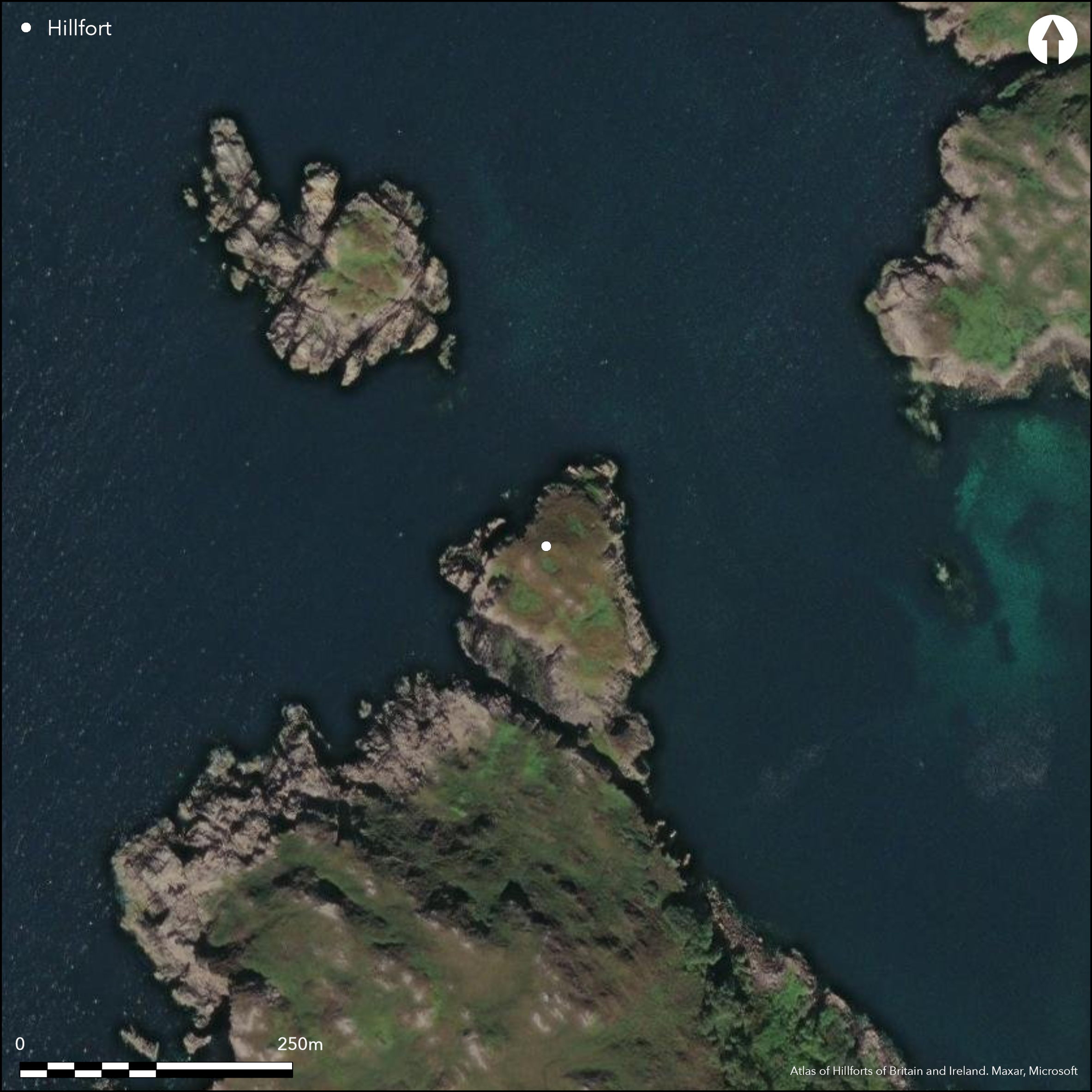
NGR: NC 0661 1551
X: 206610 Y: 915510 (OSGB36)
A heavily vitrified dun occupies the summit of a promontory which is also cut off on the landward side by the remains of a wall drawn obliquely across its relatively narrow neck. The dun measures about 12.5m in diameter within a heavily vitrified wall in the order of 5m in thickness, and there is another heavily vitrified wall forming a small annexe on a lower terrace on its SW flank. The outer wall barring access to the promontory from the S is reduced to little more than a band of rubble spanning the neck between two clefts in its rocky flanks and extending a little way along its SW margin; a single small mass of vitrifaction has been observed amongst the rubble, and there is a gap for an entrance towards the W side. To its rear the promontory is roughly triangular on plan, measuring a 100m from N to S along its E flank by a maximum of 60m transversely (0.39ha). The relationship between the dun and the wall across the promontory is unknown.
Citizen Science: ✗
Reliability of Data: Confirmed
Reliability of Interpretation: Confirmed
X: -587996 Y: 7985481 (EPSG: 3857)
Longitude: -5.2820615959512685 Latitude: 58.086362357048486 (EPSG:4326)
Country: Scotland
Current County or Unitary Authority: Highland
Historic County: Ross-shire
Current Parish/Community/Council/Townland: Lochbroom
None
| Extant | ✓ |
| Cropmark | ✗ |
| Likely Destroyed | ✗ |
None
| Woodland | ✗ |
| Commercial Forestry Plantation | ✗ |
| Parkland | ✗ |
| Pasture (Grazing) | ✓ |
| Arable | ✗ |
| Scrub/Bracken | ✗ |
| Bare Outcrop | ✗ |
| Heather/Moorland | ✓ |
| Heath | ✗ |
| Built-up | ✗ |
| Coastal Grassland | ✗ |
| Other | ✗ |
None
| Contour Fort | ✗ |
| Partial Contour Fort | ✗ |
| Promontory Fort | ✓ |
| Hillslope Fort | ✗ |
| Level Terrain Fort | ✗ |
| Marsh Fort | ✗ |
| Multiple Enclosure Fort | ✗ |
| Hilltop | ✗ |
| Coastal Promontory | ✓ |
| Inland Promontory | ✗ |
| Valley Bottom | ✗ |
| Knoll/Hillock/Outcrop | ✗ |
| Ridge | ✗ |
| Cliff/Plateau-edge/Scarp | ✗ |
| Hillslope | ✗ |
| Lowland | ✗ |
| Spur | ✗ |
Dominant Topographic Feature: None
| North | ✗ |
| Northeast | ✗ |
| East | ✗ |
| Southeast | ✗ |
| South | ✗ |
| Southwest | ✗ |
| West | ✗ |
| Northwest | ✗ |
| Level | ✓ |
Altitude: 23.0m
N/A
In the absence of excavation, there are neither stratified artefacts nor radiocarbon dates to provide a chronology for the defences.
Reliability: D - None
| Pre 1200BC | ✗ |
| 1200BC - 800BC | ✗ |
| 800BC - 400BC | ✗ |
| 400BC - AD50 | ✗ |
| AD50 - AD400 | ✗ |
| AD400 - AD 800 | ✗ |
| Post AD800 | ✗ |
| Unknown | ✓ |
| Pre Hillfort: | None |
| Post Hillfort: | None |
RCAHMS holds a series of photographs taken by Helen Nisbet.
| 1st Identified Written Reference (1961): | Map annotation by Iain Crawford |
| 1st Identified Map Depiction (1962): | Visited by the OS |
| Other (1973): | Visited and photographed by Helen Nisbet (1974; 1975) |
| Earthwork Survey (1974): | Revised at 1:10,000 by the OS and surveyed at 1:1250 by Alan Ayre |
Partly occupied by the dun and its annexe
None
| None | ✓ |
| Spring | ✗ |
| Stream | ✗ |
| Pool | ✗ |
| Flush | ✗ |
| Well | ✗ |
| Other | ✗ |
Dun
| No Known Features | ✗ |
| Round Stone Structures | ✗ |
| Rectangular Stone Structures | ✗ |
| Curvilinear Platforms | ✗ |
| Other Roundhouse Evidence | ✗ |
| Pits | ✗ |
| Quarry Hollows | ✗ |
| Other | ✓ |
None
| No Known Excavation | ✓ |
| Pits | ✗ |
| Postholes | ✗ |
| Roundhouses | ✗ |
| Rectangular Structures | ✗ |
| Roads/Tracks | ✗ |
| Quarry Hollows | ✗ |
| Other | ✗ |
| Nothing Found | ✗ |
None
| No Known Geophysics | ✓ |
| Pits | ✗ |
| Roundhouses | ✗ |
| Rectangular Structures | ✗ |
| Roads/Tracks | ✗ |
| Quarry Hollows | ✗ |
| Other | ✗ |
| Nothing Found | ✗ |
None
| No Known Finds | ✓ |
| Pottery | ✗ |
| Metal | ✗ |
| Metalworking | ✗ |
| Human Bones | ✗ |
| Animal Bones | ✗ |
| Lithics | ✗ |
| Environmental | ✗ |
| Other | ✗ |
Dun
| APs Not Checked | ✗ |
| None | ✗ |
| Roundhouses | ✗ |
| Rectangular Structures | ✗ |
| Pits | ✗ |
| Postholes | ✗ |
| Roads/Tracks | ✗ |
| Other | ✓ |
See main summary
| 1: | Heavily reduced wall |
| 2: | None |
Guard Chambers: ✗
Chevaux de Frise: ✗
| 1. Simple Gap (South): | None |
Single wall across a promontory with single piece of vitrified stone observed.
| Area 1: | 0.39ha. |
| Total: | 0.39ha. |
Total Footprint Area: Noneha.
None
| ✗ | None |
| ✗ | This excludes the vitrified walls of the dun and its annexe |
| NE Quadrant: | 0 |
| SE Quadrant: | 1 |
| SW Quadrant: | 0 |
| NW Quadrant: | 0 |
| Total: | 1 |
| Partial Univallate | ✓ |
| Univallate | ✗ |
| Partial Bivallate | ✗ |
| Bivallate | ✗ |
| Partial Multivallate | ✗ |
| Multivallate | ✗ |
| Unknown | ✗ |
| Partial Univallate | ✗ |
| Univallate | ✗ |
| Partial Bivallate | ✗ |
| Bivallate | ✗ |
| Partial Multivallate | ✗ |
| Multivallate | ✗ |
The dun and its annexe is heavily vitrified, displaying massive vitrifaction. A single piece of vitrifaction has been observed in the line of the possible fort wall.
| None | ✗ |
| Earthen Bank | ✗ |
| Stone Wall | ✗ |
| Rubble | ✓ |
| Wall-walk | ✗ |
| Evidence of Timber | ✗ |
| Vitrification | ✓ |
| Other Burning | ✗ |
| Palisade | ✗ |
| Counter Scarp Bank | ✗ |
| Berm | ✗ |
| Unfinished | ✗ |
| Other | ✗ |
None
| None | ✗ |
| Earthen Bank | ✗ |
| Stone Wall | ✗ |
| Murus Duplex | ✗ |
| Timber-framed | ✗ |
| Timber-laced | ✗ |
| Vitrification | ✗ |
| Other Burning | ✗ |
| Palisade | ✗ |
| Counter Scarp Bank | ✗ |
| Berm | ✗ |
| Unfinished | ✗ |
| No Known Excavation | ✓ |
| Other | ✗ |
| ✗ | None |
| ✗ | None |
Number of Ditches: None
| ✗ | None |
Feachem, R (1963) A guide to prehistoric Scotland. Batsford: London (p 149-50)
Nisbet, H C (1974) 'A geological approach to vitrified forts, part I: the archaeological and scientific background'. Sci & Archaeol 12 (1974), 3-12
Nisbet, H C (1975) 'A geological approach to vitrified forts, part II: bedrock and building stone'. Sci & Archaeol 15 (1975), 11
Atlas of Hillforts:
Wikidata:
This work is licensed under CC BY-SA 4.0![]()
![]()
![]() and should be cited as:
and should be cited as:
Lock, Gary and Ralston, Ian. 2024. Atlas of Hillforts of Britain and Ireland. Available at: https://hillforts.arch.ox.ac.uk
Document Version 1.1