Satellite Imagery
Satellite Imagery
HER: Highland HER MHG10835 (None)
NMR: NC 80 NW 4 (6506)
SM: None
NGR: NC 8229 0987
X: 282290 Y: 909870 (OSGB36)
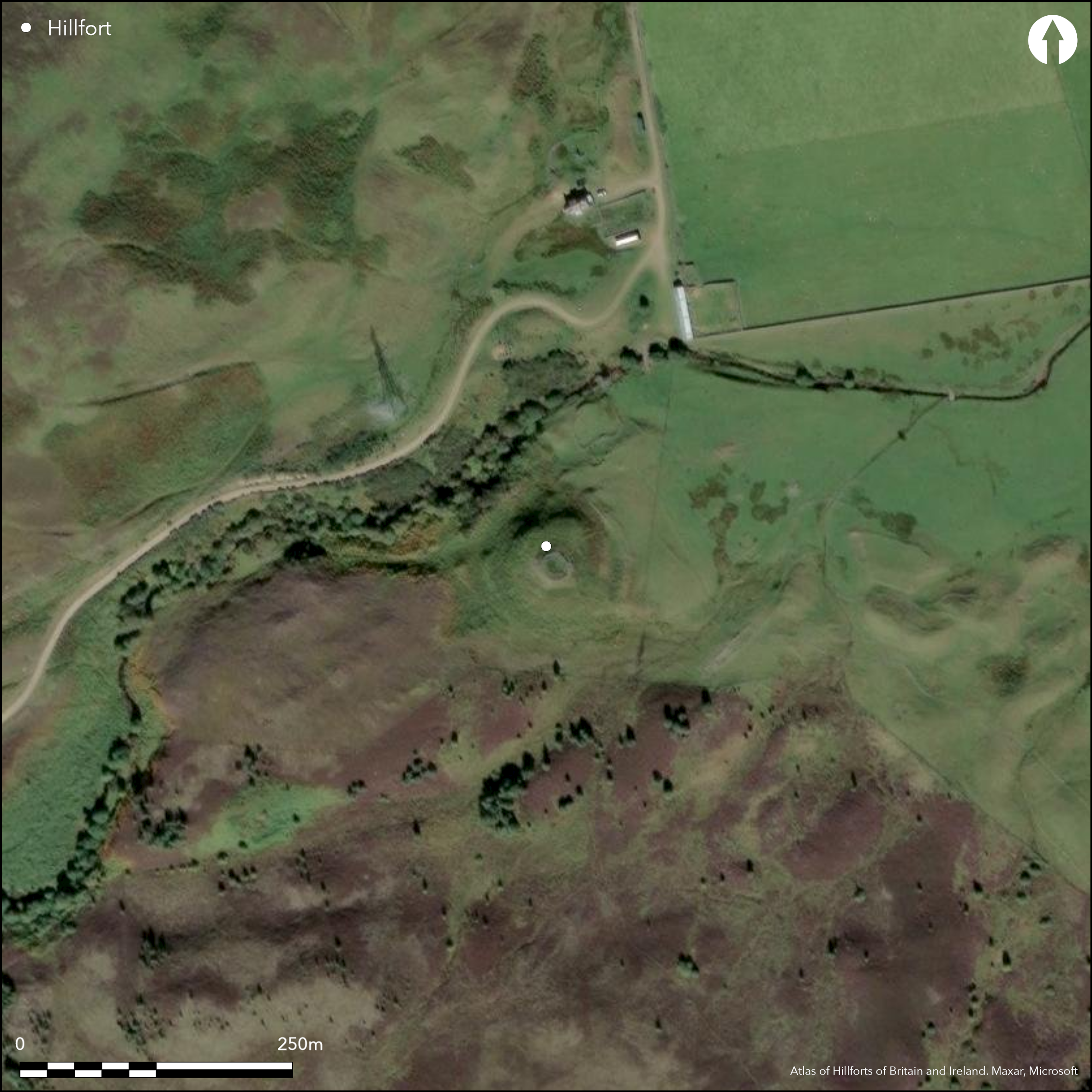
This broch which has been reduced to a mound of rubble and is overlain by what is probably a small sheepfold, stands in the middle of a strongly defended outer enclosure occupying the whole of the summit of a hillock on the SE bank of the Scottarie Burn above Kilbraur. The flanks of the hillock have evidently been scarped, creating a ditch with a well-defined counterscarp rampart in places on the NE and SW, but there are also traces of a robbed wall extending round the rim of the hillock to enclose an area measuring about 36m in diameter (0.1ha). A short length of what may be an outer ditch can be seen above the burn gully on the WSW, but the whole of the NW flank has been slighted by the construction of a mill race. Another post-medieval enclosure is set in the ditch on the E
Citizen Science: ✗
Reliability of Data: Confirmed
Reliability of Interpretation: Unconfirmed
X: -444909 Y: 7980422 (EPSG: 3857)
Longitude: -3.996683602570739 Latitude: 58.062325532016835 (EPSG:4326)
Country: Scotland
Current County or Unitary Authority: Highland
Historic County: Sutherland
Current Parish/Community/Council/Townland: Clyne
None
| Extant | ✓ |
| Cropmark | ✗ |
| Likely Destroyed | ✗ |
None
| Woodland | ✗ |
| Commercial Forestry Plantation | ✗ |
| Parkland | ✗ |
| Pasture (Grazing) | ✓ |
| Arable | ✗ |
| Scrub/Bracken | ✗ |
| Bare Outcrop | ✗ |
| Heather/Moorland | ✓ |
| Heath | ✗ |
| Built-up | ✗ |
| Coastal Grassland | ✗ |
| Other | ✗ |
None
| Contour Fort | ✓ |
| Partial Contour Fort | ✗ |
| Promontory Fort | ✗ |
| Hillslope Fort | ✗ |
| Level Terrain Fort | ✗ |
| Marsh Fort | ✗ |
| Multiple Enclosure Fort | ✗ |
| Hilltop | ✗ |
| Coastal Promontory | ✗ |
| Inland Promontory | ✗ |
| Valley Bottom | ✗ |
| Knoll/Hillock/Outcrop | ✓ |
| Ridge | ✗ |
| Cliff/Plateau-edge/Scarp | ✗ |
| Hillslope | ✗ |
| Lowland | ✗ |
| Spur | ✗ |
Dominant Topographic Feature: None
| North | ✗ |
| Northeast | ✗ |
| East | ✗ |
| Southeast | ✗ |
| South | ✗ |
| Southwest | ✗ |
| West | ✗ |
| Northwest | ✗ |
| Level | ✓ |
Altitude: 55.0m
N/A
In the absence of excavation, there are neither stratified artefacts nor radiocarbon dates to provide a chronology for the defences.
Reliability: D - None
| Pre 1200BC | ✗ |
| 1200BC - 800BC | ✗ |
| 800BC - 400BC | ✗ |
| 400BC - AD50 | ✗ |
| AD50 - AD400 | ✗ |
| AD400 - AD 800 | ✗ |
| Post AD800 | ✗ |
| Unknown | ✓ |
| Pre Hillfort: | None |
| Post Hillfort: | Heavily robbed and occupied by a sheepfold |
RCAHMS Aerial Survey Programme have taken detailed aerial photographs of Kilbraur in 2009 and also hold two images taken in 1972 by John Dewar. Highland HER also hold slides and photographs.
| 1st Identified Map Depiction (1872): | Annotated 'Pictish Tower' on the 1st edition OS 6-inch map (Sutherland 1879, sheet 97; Name Book, Sutherland, No.5, p 7) |
| Other (1909): | Description (RCAHMS 1911, 7, no.24) |
| Other (1964): | Visited by the OS |
| Other (1975): | Revised at 1:10,000 by the OS |
Occupied by the broch and the overlying sheepfold
None
| None | ✓ |
| Spring | ✗ |
| Stream | ✗ |
| Pool | ✗ |
| Flush | ✗ |
| Well | ✗ |
| Other | ✗ |
Broch
| No Known Features | ✗ |
| Round Stone Structures | ✗ |
| Rectangular Stone Structures | ✗ |
| Curvilinear Platforms | ✗ |
| Other Roundhouse Evidence | ✗ |
| Pits | ✗ |
| Quarry Hollows | ✗ |
| Other | ✓ |
None
| No Known Excavation | ✓ |
| Pits | ✗ |
| Postholes | ✗ |
| Roundhouses | ✗ |
| Rectangular Structures | ✗ |
| Roads/Tracks | ✗ |
| Quarry Hollows | ✗ |
| Other | ✗ |
| Nothing Found | ✗ |
None
| No Known Geophysics | ✓ |
| Pits | ✗ |
| Roundhouses | ✗ |
| Rectangular Structures | ✗ |
| Roads/Tracks | ✗ |
| Quarry Hollows | ✗ |
| Other | ✗ |
| Nothing Found | ✗ |
None
| No Known Finds | ✓ |
| Pottery | ✗ |
| Metal | ✗ |
| Metalworking | ✗ |
| Human Bones | ✗ |
| Animal Bones | ✗ |
| Lithics | ✗ |
| Environmental | ✗ |
| Other | ✗ |
Broch
| APs Not Checked | ✗ |
| None | ✗ |
| Roundhouses | ✗ |
| Rectangular Structures | ✗ |
| Pits | ✗ |
| Postholes | ✗ |
| Roads/Tracks | ✗ |
| Other | ✓ |
None known
| 0: | NW sector slighted |
| 2: | Not known |
Guard Chambers: ✗
Chevaux de Frise: ✗
Rampart and ditch accompanied in some sectors by a counterscarp bank.
| Area 1: | 0.1ha. |
| Total: | 0.1ha. |
Total Footprint Area: 0.4ha.
None
| ✗ | None |
| ✓ | None |
| NE Quadrant: | 2 |
| SE Quadrant: | 1 |
| SW Quadrant: | 2 |
| NW Quadrant: | 1 |
| Total: | 2 |
| Partial Univallate | ✓ |
| Univallate | ✗ |
| Partial Bivallate | ✓ |
| Bivallate | ✗ |
| Partial Multivallate | ✗ |
| Multivallate | ✗ |
| Unknown | ✗ |
| Partial Univallate | ✗ |
| Univallate | ✗ |
| Partial Bivallate | ✗ |
| Bivallate | ✗ |
| Partial Multivallate | ✗ |
| Multivallate | ✗ |
None
| None | ✗ |
| Earthen Bank | ✓ |
| Stone Wall | ✗ |
| Rubble | ✓ |
| Wall-walk | ✗ |
| Evidence of Timber | ✗ |
| Vitrification | ✗ |
| Other Burning | ✗ |
| Palisade | ✗ |
| Counter Scarp Bank | ✗ |
| Berm | ✗ |
| Unfinished | ✗ |
| Other | ✗ |
None
| None | ✗ |
| Earthen Bank | ✗ |
| Stone Wall | ✗ |
| Murus Duplex | ✗ |
| Timber-framed | ✗ |
| Timber-laced | ✗ |
| Vitrification | ✗ |
| Other Burning | ✗ |
| Palisade | ✗ |
| Counter Scarp Bank | ✗ |
| Berm | ✗ |
| Unfinished | ✗ |
| No Known Excavation | ✓ |
| Other | ✗ |
| ✗ | None |
| ✓ | short segment of a second ditch on one side |
Number of Ditches: 1
| ✗ | None |
Name Book, Ordnance Survey Object Name Books (6 inch and 1/2500 scale); available https://www.scotlandsplaces.gov.uk/
RCAHMS (1911) The Royal Commission on the Ancient and Historical Monuments and Constructions of Scotland. Second report and inventory of monuments and constructions in the county of Sutherland. HMSO: Edinburgh
Atlas of Hillforts:
Wikidata:
This work is licensed under CC BY-SA 4.0![]()
![]()
![]() and should be cited as:
and should be cited as:
Lock, Gary and Ralston, Ian. 2024. Atlas of Hillforts of Britain and Ireland. Available at: https://hillforts.arch.ox.ac.uk
Document Version 1.1