Satellite Imagery
Satellite Imagery
HER: Orkney Islands 9561 (None)
NMR: ND 48 SW 2 (9561)
SM: None
NGR: ND 4348 8423
X: 343480 Y: 984230 (OSGB36)
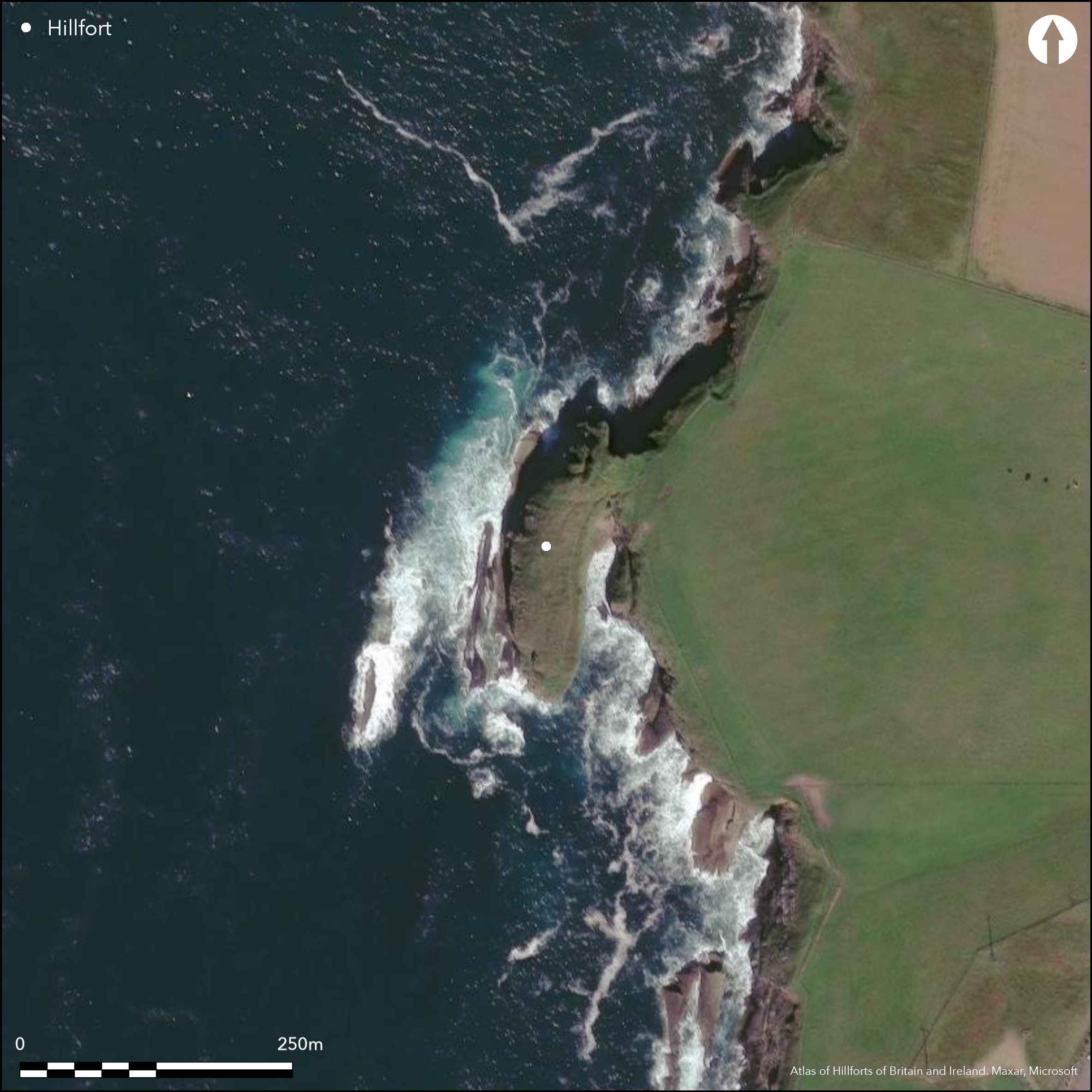
A precipitous promontory on the W coast of the Burwick headland, which itself lies on the W coast of South Ronaldsay, is defended by a series of ramparts and ditches. Forming a long narrow hammerhead and measuring about 100m from N to S by up to 26m transversely, the promontory is linked to the mainland by a narrow neck at the N end of the E side, which also forms a shallow saddle. A stony scarp on the seaward side of the saddle is probably the innermost rampart, outside which at least three and probably four ditches have been drawn across the neck, the innermost straight across the narrowest point and the outermost in a gentle arc; they are separated by upcast ramparts up to 5m in thickness by 2m in height. While the neck provides the only access, the exact position of the entrance is unknown. To the rear of the inner rampart, there are the footings of a rectangular building measuring about 12m from N to S by 4m internally, and the remains of at least ten other buildings can be seen elsewhere, leading to comparisons with monastic sites such as the Brough of Deerness (Lamb 1973, 78); in addition traces of a turf bank extend along the length of the E margin of the promontory. Midden material has been noted eroding from the cliff-edge along the W margin of the promontory ever since 1929 (RCAHMS 1946, 285, no.817; Wilson and Moore 1997), and this probably accounts for the description of broken bones appearing in the Name Book (Orkney, No.20, p 327), though whether the two supposed cists recorded then were the remains of burials or the fittings of internal buildings is unknown.
Citizen Science: ✗
Reliability of Data: Confirmed
Reliability of Interpretation: Confirmed
X: -331530 Y: 8124857 (EPSG: 3857)
Longitude: -2.978184084723046 Latitude: 58.7421201050114 (EPSG:4326)
Country: Scotland
Current County or Unitary Authority: Orkney Islands
Historic County: Orkney
Current Parish/Community/Council/Townland: South Ronaldsay
None
| Extant | ✓ |
| Cropmark | ✗ |
| Likely Destroyed | ✗ |
None
| Woodland | ✗ |
| Commercial Forestry Plantation | ✗ |
| Parkland | ✗ |
| Pasture (Grazing) | ✗ |
| Arable | ✗ |
| Scrub/Bracken | ✗ |
| Bare Outcrop | ✗ |
| Heather/Moorland | ✗ |
| Heath | ✗ |
| Built-up | ✗ |
| Coastal Grassland | ✓ |
| Other | ✗ |
None
| Contour Fort | ✗ |
| Partial Contour Fort | ✗ |
| Promontory Fort | ✓ |
| Hillslope Fort | ✗ |
| Level Terrain Fort | ✗ |
| Marsh Fort | ✗ |
| Multiple Enclosure Fort | ✗ |
| Hilltop | ✗ |
| Coastal Promontory | ✓ |
| Inland Promontory | ✗ |
| Valley Bottom | ✗ |
| Knoll/Hillock/Outcrop | ✗ |
| Ridge | ✗ |
| Cliff/Plateau-edge/Scarp | ✗ |
| Hillslope | ✗ |
| Lowland | ✗ |
| Spur | ✗ |
Dominant Topographic Feature: None
| North | ✗ |
| Northeast | ✗ |
| East | ✗ |
| Southeast | ✗ |
| South | ✗ |
| Southwest | ✗ |
| West | ✗ |
| Northwest | ✗ |
| Level | ✓ |
Altitude: 20.0m
N/A
In the absence of excavation, there are neither stratified artefacts nor radiocarbon dates to provide a chronology for the defences.
Reliability: D - None
| Pre 1200BC | ✗ |
| 1200BC - 800BC | ✗ |
| 800BC - 400BC | ✗ |
| 400BC - AD50 | ✗ |
| AD50 - AD400 | ✗ |
| AD400 - AD 800 | ✓ |
| Post AD800 | ✓ |
| Unknown | ✗ |
| Pre Hillfort: | None |
| Post Hillfort: | None |
| Morphology/Earthwork/Typology: | None |
Photographed by RCAHMS Aerial Survey Programme in 2009
| 1st Identified Written Reference (1774): | Noted by Rev G Low (1879, 28) |
| 1st Identified Map Depiction (1879): | Named in Gothic type on the 1st edition OS 25-inch map (Orkney 1882, sheet 126.6; Name Book, Orkney, No.20, p 327) |
| Earthwork Survey (1929): | Plan and description ((RCAHMS 1946, ii, 285, no.817, fig 365; RCAHMS ORD 108/1-2) |
| Other (1970): | Noted and photographed by Raymond Lamb with plan adapted from RCAHMS (1973, 78; 1980, 52, 53, 58, 76-7; RCAHMS ORD 108/3) |
| Other (1973): | Surveyed at 1:2500 by the OS |
| Other (1997): | Description (Wilson and Moore 1997 and Coastal Zone Assessment held by RCAHMS MS1031/4) |
Up to eleven rectangular buildings
None
| None | ✓ |
| Spring | ✗ |
| Stream | ✗ |
| Pool | ✗ |
| Flush | ✗ |
| Well | ✗ |
| Other | ✗ |
None
| No Known Features | ✗ |
| Round Stone Structures | ✗ |
| Rectangular Stone Structures | ✓ |
| Curvilinear Platforms | ✗ |
| Other Roundhouse Evidence | ✗ |
| Pits | ✗ |
| Quarry Hollows | ✗ |
| Other | ✗ |
None
| No Known Excavation | ✓ |
| Pits | ✗ |
| Postholes | ✗ |
| Roundhouses | ✗ |
| Rectangular Structures | ✗ |
| Roads/Tracks | ✗ |
| Quarry Hollows | ✗ |
| Other | ✗ |
| Nothing Found | ✗ |
None
| No Known Geophysics | ✓ |
| Pits | ✗ |
| Roundhouses | ✗ |
| Rectangular Structures | ✗ |
| Roads/Tracks | ✗ |
| Quarry Hollows | ✗ |
| Other | ✗ |
| Nothing Found | ✗ |
Midden deposits eroding along the margin of the promontory
| No Known Finds | ✗ |
| Pottery | ✓ |
| Metal | ✗ |
| Metalworking | ✗ |
| Human Bones | ✗ |
| Animal Bones | ✓ |
| Lithics | ✓ |
| Environmental | ✗ |
| Other | ✗ |
None
| APs Not Checked | ✗ |
| None | ✗ |
| Roundhouses | ✗ |
| Rectangular Structures | ✓ |
| Pits | ✗ |
| Postholes | ✗ |
| Roads/Tracks | ✗ |
| Other | ✗ |
See main summary
| 0: | None |
| 2: | Not visible, but must cross the neck on the E |
Guard Chambers: ✗
Chevaux de Frise: ✗
Up to four ramparts and ditches cutting off a promontory
| Area 1: | 0.17ha. |
| Total: | 0.17ha. |
Total Footprint Area: Noneha.
None
| ✗ | None |
| ✗ | None |
| NE Quadrant: | 4 |
| SE Quadrant: | 0 |
| SW Quadrant: | 0 |
| NW Quadrant: | 0 |
| Total: | 4 |
| Partial Univallate | ✗ |
| Univallate | ✗ |
| Partial Bivallate | ✗ |
| Bivallate | ✗ |
| Partial Multivallate | ✓ |
| Multivallate | ✗ |
| Unknown | ✗ |
| Partial Univallate | ✗ |
| Univallate | ✗ |
| Partial Bivallate | ✗ |
| Bivallate | ✗ |
| Partial Multivallate | ✗ |
| Multivallate | ✗ |
None
| None | ✗ |
| Earthen Bank | ✓ |
| Stone Wall | ✗ |
| Rubble | ✗ |
| Wall-walk | ✗ |
| Evidence of Timber | ✗ |
| Vitrification | ✗ |
| Other Burning | ✗ |
| Palisade | ✗ |
| Counter Scarp Bank | ✗ |
| Berm | ✗ |
| Unfinished | ✗ |
| Other | ✗ |
None
| None | ✗ |
| Earthen Bank | ✗ |
| Stone Wall | ✗ |
| Murus Duplex | ✗ |
| Timber-framed | ✗ |
| Timber-laced | ✗ |
| Vitrification | ✗ |
| Other Burning | ✗ |
| Palisade | ✗ |
| Counter Scarp Bank | ✗ |
| Berm | ✗ |
| Unfinished | ✗ |
| No Known Excavation | ✓ |
| Other | ✗ |
| ✗ | None |
| ✓ | None |
Number of Ditches: 4
| ✗ | None |
Lamb, R G (1973) 'Coastal settlements of the north'. Scot Archaeol Forum 5 (1973), 76-98
Lamb, R G (1980) Iron Age promontory forts in the Northern Isles. Brit Archaeol Rep, British Ser 79. BAR: Oxford
Low, G (1879) A Tour through the Islands of Orkney and Schetland in 1774 (Anderson, J, ed). Kirkwall
Name Book, Ordnance Survey Object Name Books (6 inch and 1/2500 scale); available https://www.scotlandsplaces.gov.uk/
RCAHMS (1946) The Royal Commission on the Ancient and Historical Monuments of Scotland. Twelfth report with an inventory of the ancient monuments of Orkney and Shetland, 3v. HMSO: Edinburgh
Wilson and Moore, G and H (1997) 'Orkney Coastal Survey (South Ronaldsay; Walls & Flotta; Hoy & Graemsay parishes)'. Disc Exc Scot (1997), 58-9
Atlas of Hillforts:
Wikidata:
This work is licensed under CC BY-SA 4.0![]()
![]()
![]() and should be cited as:
and should be cited as:
Lock, Gary and Ralston, Ian. 2024. Atlas of Hillforts of Britain and Ireland. Available at: https://hillforts.arch.ox.ac.uk
Document Version 1.1