Satellite Imagery
Satellite Imagery
HER: Highland HER MHG45224 (None)
NMR: ND 36 NE 1 (9260)
SM: 2372
NGR: ND 3814 6665
X: 338140 Y: 966650 (OSGB36)
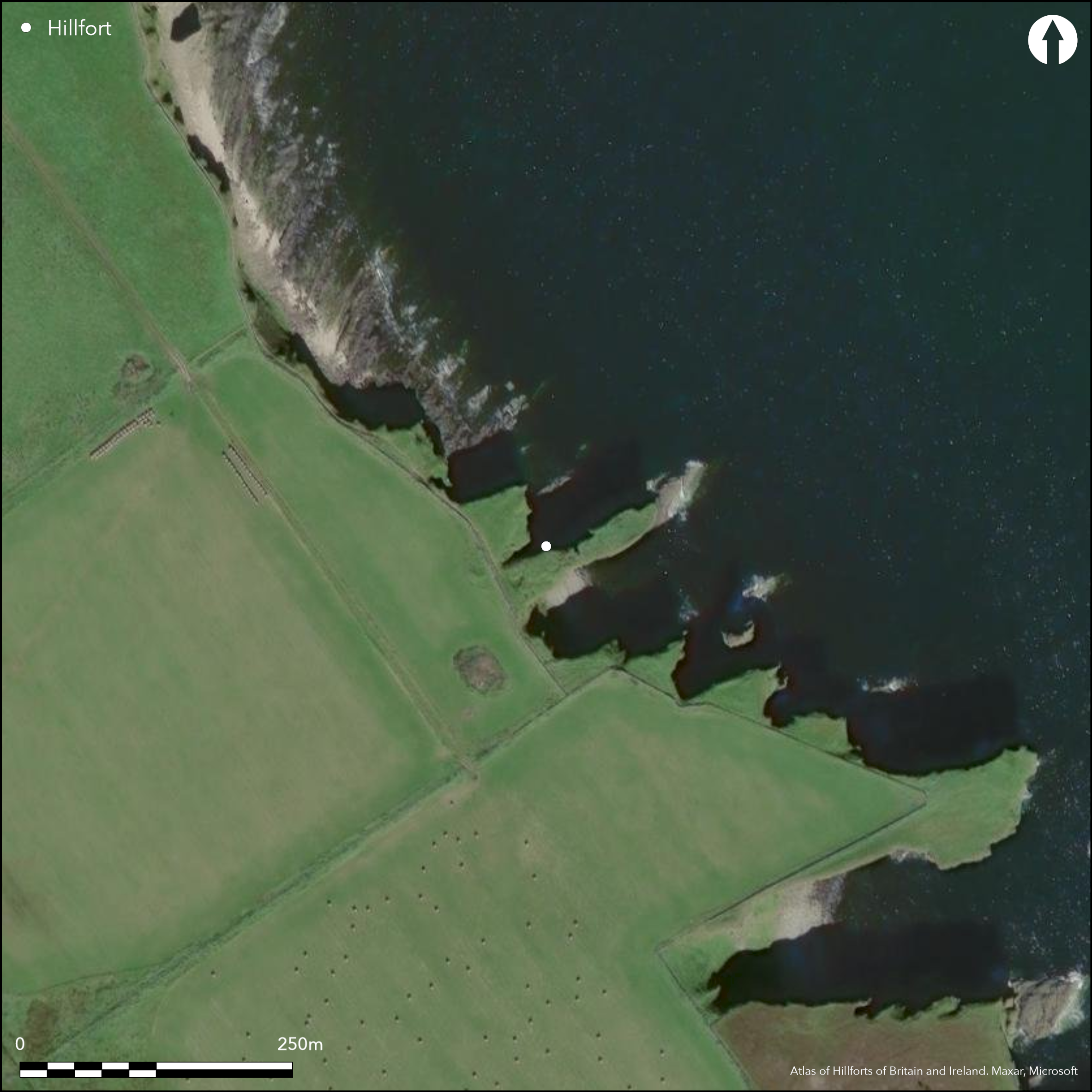
The remains of the broch on a precipitous promontory NW of Ness Head stand behind what has probably been a stout wall with an external ditch, which bar access to the promontory across its neck on the SW. The wall, which has been drawn across the neck in a shallow arc, stood some 1.8m high when it was exposed in excavation by Sir Francis Tress Barry (Anderson 1901, 143) and has an entrance towards its SE end. Little trace of the probable ditch can be seen, partly because it is overlain to the NW of the entrance by later structures which extend NW beyond the eroded cleft of the geo running in from the sea on this side. Immediately outside the wall on the SE of the entrance Barry uncovered steps leading down into a slab-covered well 2.9m deep. The broch itself has been heavily eroded, but measures about 6.6m in diameter within a wall up to 4.6m in thickness, with possibly two entrances, that on the E with a guard chamber, and also another chamber in the wall on the NE. There are traces of buildings between the broch and the outer wall across the promontory on the WSW, and also on the seaward side on the ENE. The promontory has evidently been heavily eroded, and the interior behind the outer wall may originally have been considerably larger; it currently measures about 68m from ENE to WSW by up to 14m transversely (0.08ha), and there are traces of a low bank extending around its lip on the seaward end beyond the broch. The finds from the excavations reported by Anderson are: three quernstones, several stone vessels, a sandstone ingot mould, two bronze ingots, a bronze pin and links from a bronze chain (see also Proc Soc Antiq Scot 43 (1908-9), 15-16).
Citizen Science: ✗
Reliability of Data: Confirmed
Reliability of Interpretation: Confirmed
X: -341261 Y: 8090911 (EPSG: 3857)
Longitude: -3.0656010251946086 Latitude: 58.58352800693989 (EPSG:4326)
Country: Scotland
Current County or Unitary Authority: Highland
Historic County: Caithness
Current Parish/Community/Council/Townland: Canisbay
None
| Extant | ✓ |
| Cropmark | ✗ |
| Likely Destroyed | ✗ |
None
| Woodland | ✗ |
| Commercial Forestry Plantation | ✗ |
| Parkland | ✗ |
| Pasture (Grazing) | ✗ |
| Arable | ✗ |
| Scrub/Bracken | ✗ |
| Bare Outcrop | ✗ |
| Heather/Moorland | ✗ |
| Heath | ✗ |
| Built-up | ✗ |
| Coastal Grassland | ✓ |
| Other | ✗ |
None
| Contour Fort | ✗ |
| Partial Contour Fort | ✗ |
| Promontory Fort | ✓ |
| Hillslope Fort | ✗ |
| Level Terrain Fort | ✗ |
| Marsh Fort | ✗ |
| Multiple Enclosure Fort | ✗ |
| Hilltop | ✗ |
| Coastal Promontory | ✓ |
| Inland Promontory | ✗ |
| Valley Bottom | ✗ |
| Knoll/Hillock/Outcrop | ✗ |
| Ridge | ✗ |
| Cliff/Plateau-edge/Scarp | ✗ |
| Hillslope | ✗ |
| Lowland | ✗ |
| Spur | ✗ |
Dominant Topographic Feature: None
| North | ✗ |
| Northeast | ✗ |
| East | ✗ |
| Southeast | ✗ |
| South | ✗ |
| Southwest | ✗ |
| West | ✗ |
| Northwest | ✗ |
| Level | ✓ |
Altitude: 15.0m
N/A
No closely datable artefacts from the excavation of the broch
Reliability: D - None
| Pre 1200BC | ✗ |
| 1200BC - 800BC | ✗ |
| 800BC - 400BC | ✗ |
| 400BC - AD50 | ✗ |
| AD50 - AD400 | ✗ |
| AD400 - AD 800 | ✗ |
| Post AD800 | ✗ |
| Unknown | ✓ |
| Pre Hillfort: | None |
| Post Hillfort: | Possibly overlain by the broch and external buildings |
RCAHMS collection holds an extensive photographic archive, including those by Francis Tress Barry of his excavations, and also aerial photographs by CUCAP and RCAHMS Aerial Survey Programme, the most recent by the latter dating from 2002 and 2013
| Excavation (1898): | Excavation by Sir Francis Tress Barry, reported by Joseph Anderson (1901, 143; RCAHMS DC48538; C7570- 6 ) |
| 1st Identified Map Depiction (1905): | Annotated Brough on the 2nd edition OS 25-inch map (Caithness 1906, sheet 8.14) |
| Earthwork Survey (1910): | Plan published in the Caithness County Inventory, probably derived from John Nicolson for Sir Francis Tress Barry (RCAHMS 1911, 13-14, no.33, fig 5; RCAHMS CAD 8/1-2) |
| Other (1963): | Scheduled |
| Other (1963): | Visited by Euan MacKie (2007, 476-7) |
| Other (1965): | Resurveyed at 1:2500 by the OS |
| Other (1971): | Visited and photographed by Raymond Lamb (1980, 20, 74, 96) |
| Excavation (1972): | Limited clearance by Euan MacKie to obtain ground plan of broch (1972; 2007, 476-7) |
| Other (1981): | Visited by Caithness Coastal Survey (Batey 1982; RCAHMS MS 154) |
| Other (1982): | Visited by the OS |
| Other (1985): | Description and derived plan (Swanson 1988, 562-7, cited by MacKie 2007, 476-7) |
Partly occupied by the broch, but evidently there are also other structures
External well
| None | ✗ |
| Spring | ✗ |
| Stream | ✗ |
| Pool | ✗ |
| Flush | ✗ |
| Well | ✓ |
| Other | ✗ |
Broch
| No Known Features | ✗ |
| Round Stone Structures | ✗ |
| Rectangular Stone Structures | ✗ |
| Curvilinear Platforms | ✗ |
| Other Roundhouse Evidence | ✗ |
| Pits | ✗ |
| Quarry Hollows | ✗ |
| Other | ✓ |
Broch and external buildings of various forms
| No Known Excavation | ✗ |
| Pits | ✗ |
| Postholes | ✗ |
| Roundhouses | ✗ |
| Rectangular Structures | ✗ |
| Roads/Tracks | ✗ |
| Quarry Hollows | ✗ |
| Other | ✓ |
| Nothing Found | ✗ |
None
| No Known Geophysics | ✓ |
| Pits | ✗ |
| Roundhouses | ✗ |
| Rectangular Structures | ✗ |
| Roads/Tracks | ✗ |
| Quarry Hollows | ✗ |
| Other | ✗ |
| Nothing Found | ✗ |
Three quernstones, several stone vessels, a sandstone ingot mould, two bronze ingots, a bronze pin and a bronze chain (see Proc Soc Antiq Scot 43 (1908-9), 15-16 for full list of objects accesioned to the NMAS).
| No Known Finds | ✗ |
| Pottery | ✗ |
| Metal | ✓ |
| Metalworking | ✓ |
| Human Bones | ✗ |
| Animal Bones | ✓ |
| Lithics | ✓ |
| Environmental | ✗ |
| Other | ✗ |
Broch
| APs Not Checked | ✗ |
| None | ✗ |
| Roundhouses | ✗ |
| Rectangular Structures | ✗ |
| Pits | ✗ |
| Postholes | ✗ |
| Roads/Tracks | ✗ |
| Other | ✓ |
See main summary
| 1: | None |
| 2: | None |
Guard Chambers: ✗
Chevaux de Frise: ✗
| 1. Simple Gap (West): | None |
Single wall across a promontory; excludes the broch
| Area 1: | 0.08ha. |
| Total: | 0.08ha. |
Total Footprint Area: Noneha.
None
| ✗ | None |
| ✗ | Excludes the broch wall |
| NE Quadrant: | 0 |
| SE Quadrant: | 0 |
| SW Quadrant: | 1 |
| NW Quadrant: | 0 |
| Total: | 1 |
| Partial Univallate | ✓ |
| Univallate | ✗ |
| Partial Bivallate | ✗ |
| Bivallate | ✗ |
| Partial Multivallate | ✗ |
| Multivallate | ✗ |
| Unknown | ✗ |
| Partial Univallate | ✗ |
| Univallate | ✗ |
| Partial Bivallate | ✗ |
| Bivallate | ✗ |
| Partial Multivallate | ✗ |
| Multivallate | ✗ |
None
| None | ✗ |
| Earthen Bank | ✗ |
| Stone Wall | ✓ |
| Rubble | ✗ |
| Wall-walk | ✗ |
| Evidence of Timber | ✗ |
| Vitrification | ✗ |
| Other Burning | ✗ |
| Palisade | ✗ |
| Counter Scarp Bank | ✗ |
| Berm | ✗ |
| Unfinished | ✗ |
| Other | ✗ |
Excavated by Tress Barry
| None | ✗ |
| Earthen Bank | ✗ |
| Stone Wall | ✓ |
| Murus Duplex | ✗ |
| Timber-framed | ✗ |
| Timber-laced | ✗ |
| Vitrification | ✗ |
| Other Burning | ✗ |
| Palisade | ✗ |
| Counter Scarp Bank | ✗ |
| Berm | ✗ |
| Unfinished | ✗ |
| No Known Excavation | ✗ |
| Other | ✗ |
| ✗ | None |
| ✗ | None |
Number of Ditches: None
| ✗ | None |
Anderson, J (1901) 'Notices of nine Brochs along the Caithness coast from Keiss Bay to Skirza Head, excavated by Sir Francis Tress Barry, Bart., MP., of Keiss Castle, Caithness'. Proc Soc Antiq Scot 35 (1900-1, 112-53)
Batey, C E (1982) Caithness coastal survey 1982: interim reports 1980-2, typescript Durham University (Available in RCAHMS ).
Lamb, R G (1980) Iron Age promontory forts in the Northern Isles. Brit Archaeol Rep, British Ser 79. BAR: Oxford
MacKie, E W (2007) The Roundhouses, Brochs and Wheelhouses of Atlantic Scotland c.700 BC-AD 500: architecture and material culture, the Northern and Southern Mainland and the Western Islands, BAR British series 444(II), 444(1), 2 V. BAR: Oxford
MacKie, E W (1972) 'Ness, broch'. Disc Exc Scot (1972), 17
RCAHMS (1911) The Royal Commission on the Ancient and Historical Monuments and Constructions of Scotland. Third report and inventory of monuments and constructions in the county of Caithness. HMSO, London
Swanson, C B (1988) A contribution to the understanding of brochs, Unpublished Ph D thesis. University of Edinburgh
Atlas of Hillforts:
Wikidata:
This work is licensed under CC BY-SA 4.0![]()
![]()
![]() and should be cited as:
and should be cited as:
Lock, Gary and Ralston, Ian. 2024. Atlas of Hillforts of Britain and Ireland. Available at: https://hillforts.arch.ox.ac.uk
Document Version 1.1