Satellite Imagery
Satellite Imagery
HER: Highland HER MHG655 (None)
NMR: ND 36 NE 2 (9271)
SM: 580
NGR: ND 3940 6844
X: 339400 Y: 968440 (OSGB36)
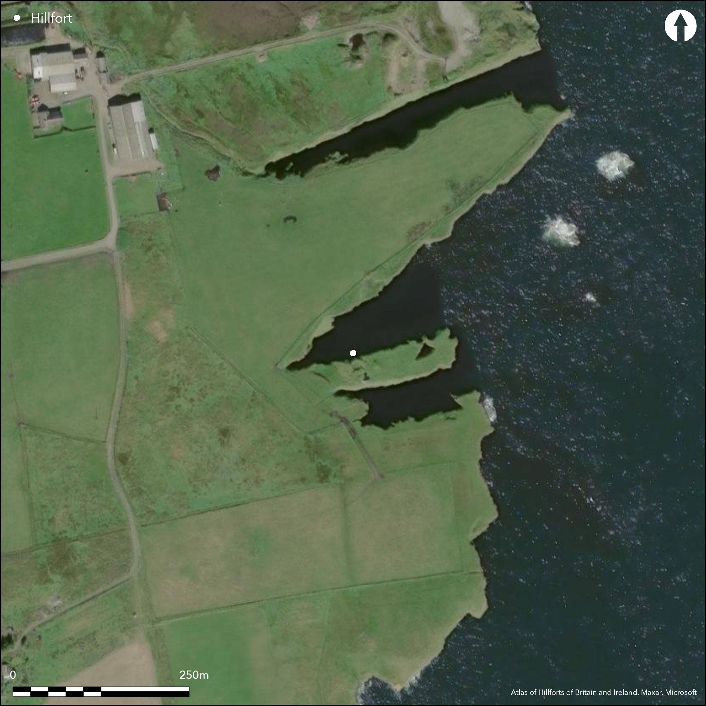
The promontory on which the broch N of Skirsa Head stands, is also defended on the W by a fortification that cuts across its neck. Excavations by Sir Francis Tress Barry in the 1890s, reported by Joseph Anderson (1901, 144-5), focused on the broch, which measures about 6.7m in diameter within a wall 4.3m in thickness; there was a checked entrance, a mural stair and what has been described as a scarcement, though the date and purpose of this feature is unclear (see discussion in MacKie 2007, 479-80). There were traces of external strucures, one of which seems to have overlain the broch, and immediately S of the entrance to the broch, which opens ESE, there is what seems to have been a chamber or well sunk some 3m deep. The outer fortification comprises a ditch about 9m in breadth set immediately in front of the broch on the landward side, and there is no record of a wall or rampart on either lip; it encloses an area measuring some 90m in length from E to W by 20m transversely (0.16ha) which has been heavily eroded along its N margin, where part of the broch wall has fallen over the cliff. Finds from the excavations include pottery, several bone tools and a comb, a piece of slag, a stone lamp and several discs, whorls and whetstones (Anderson 1901, 145; Proc Soc Antiq Scot 43 (1908-9), 16-17).
Citizen Science: ✗
Reliability of Data: Confirmed
Reliability of Interpretation: Confirmed
X: -338903 Y: 8094382 (EPSG: 3857)
Longitude: -3.044413621414777 Latitude: 58.59977934678975 (EPSG:4326)
Country: Scotland
Current County or Unitary Authority: Highland
Historic County: Caithness
Current Parish/Community/Council/Townland: Canisbay
None
| Extant | ✓ |
| Cropmark | ✗ |
| Likely Destroyed | ✗ |
None
| Woodland | ✗ |
| Commercial Forestry Plantation | ✗ |
| Parkland | ✗ |
| Pasture (Grazing) | ✗ |
| Arable | ✗ |
| Scrub/Bracken | ✗ |
| Bare Outcrop | ✗ |
| Heather/Moorland | ✗ |
| Heath | ✗ |
| Built-up | ✗ |
| Coastal Grassland | ✓ |
| Other | ✗ |
None
| Contour Fort | ✗ |
| Partial Contour Fort | ✗ |
| Promontory Fort | ✓ |
| Hillslope Fort | ✗ |
| Level Terrain Fort | ✗ |
| Marsh Fort | ✗ |
| Multiple Enclosure Fort | ✗ |
| Hilltop | ✗ |
| Coastal Promontory | ✓ |
| Inland Promontory | ✗ |
| Valley Bottom | ✗ |
| Knoll/Hillock/Outcrop | ✗ |
| Ridge | ✗ |
| Cliff/Plateau-edge/Scarp | ✗ |
| Hillslope | ✗ |
| Lowland | ✗ |
| Spur | ✗ |
Dominant Topographic Feature: None
| North | ✗ |
| Northeast | ✗ |
| East | ✗ |
| Southeast | ✗ |
| South | ✗ |
| Southwest | ✗ |
| West | ✗ |
| Northwest | ✗ |
| Level | ✓ |
Altitude: 30.0m
N/A
No closely datable artefacts from the excavation of the broch
Reliability: D - None
| Pre 1200BC | ✗ |
| 1200BC - 800BC | ✗ |
| 800BC - 400BC | ✗ |
| 400BC - AD50 | ✗ |
| AD50 - AD400 | ✗ |
| AD400 - AD 800 | ✗ |
| Post AD800 | ✗ |
| Unknown | ✓ |
| Pre Hillfort: | None |
| Post Hillfort: | Possibly overlain by the broch |
RCAHMS holds an extensive collection of photographs, including aerial views taken in 2002, while Highland HER also hold photographs
| 1st Identified Map Depiction (1873): | Annotated 'Castle' on the 1st edition OS 25-inch map (Caithness 1877, sheet 8.10) |
| Excavation (1901): | Excavated and photographed by Sir Francis Tress Barry in the 1890s and reported by Joseph Anderson (1901, 144-5; RCAHMS C7564-6; A53268-9) |
| Other (1910): | Description (RCAHMS 1911, 15-16, no.35) |
| Other (1938): | Scheduled |
| Other (1963): | Description by Euan MacKie (2007, 479-80) |
| Other (1965): | Resurveyed at 1:2500 by the OS |
| Other (1971): | Visited and photographed by Raymond Lamb (1980) |
| Excavation (1972): | Limited exposure of the wall to reveal the ground-plan (MacKie 1972) |
| Other (1980): | Visited for the Caithness Coastal Survey (Batey 1982) |
| Other (1982): | Visited by the OS |
| Other (1985): | Description and sketch-plan (Swanson 1988, 553-7, cited by MacKie 2007, 479-80) |
| Earthwork Survey (2000): | Total station survey (Heald and Jackson 2000) |
Featureless apart from the broch
None
| None | ✗ |
| Spring | ✗ |
| Stream | ✗ |
| Pool | ✗ |
| Flush | ✗ |
| Well | ✓ |
| Other | ✗ |
Broch and the hollow where the well was uncovered
| No Known Features | ✗ |
| Round Stone Structures | ✗ |
| Rectangular Stone Structures | ✗ |
| Curvilinear Platforms | ✗ |
| Other Roundhouse Evidence | ✗ |
| Pits | ✗ |
| Quarry Hollows | ✗ |
| Other | ✓ |
Broch and well
| No Known Excavation | ✗ |
| Pits | ✗ |
| Postholes | ✗ |
| Roundhouses | ✗ |
| Rectangular Structures | ✗ |
| Roads/Tracks | ✗ |
| Quarry Hollows | ✗ |
| Other | ✓ |
| Nothing Found | ✗ |
None
| No Known Geophysics | ✓ |
| Pits | ✗ |
| Roundhouses | ✗ |
| Rectangular Structures | ✗ |
| Roads/Tracks | ✗ |
| Quarry Hollows | ✗ |
| Other | ✗ |
| Nothing Found | ✗ |
Several bone tools and a comb, a piece of slag, a stone lamp and several discs, whorls and whetstones, and several sherds of pottery akin to Hebridean wares (Anderson 1901, 145; Proc Soc Antiq Scot 43 (1908-9), 16-17).
| No Known Finds | ✗ |
| Pottery | ✓ |
| Metal | ✗ |
| Metalworking | ✓ |
| Human Bones | ✗ |
| Animal Bones | ✓ |
| Lithics | ✓ |
| Environmental | ✗ |
| Other | ✗ |
Broch
| APs Not Checked | ✗ |
| None | ✗ |
| Roundhouses | ✗ |
| Rectangular Structures | ✗ |
| Pits | ✗ |
| Postholes | ✗ |
| Roads/Tracks | ✗ |
| Other | ✓ |
None known
| 0: | None |
| 2: | None Known, but must be across the neck on the WSW |
Guard Chambers: ✗
Chevaux de Frise: ✗
Single ditch, presumably accompanied by a wall or rampart cutting off a promontory
| Area 1: | 0.16ha. |
| Total: | 0.16ha. |
Total Footprint Area: Noneha.
None
| ✗ | None |
| ✗ | Excludes the broch wall |
| NE Quadrant: | 0 |
| SE Quadrant: | 0 |
| SW Quadrant: | 1 |
| NW Quadrant: | 0 |
| Total: | 1 |
| Partial Univallate | ✓ |
| Univallate | ✗ |
| Partial Bivallate | ✗ |
| Bivallate | ✗ |
| Partial Multivallate | ✗ |
| Multivallate | ✗ |
| Unknown | ✗ |
| Partial Univallate | ✗ |
| Univallate | ✗ |
| Partial Bivallate | ✗ |
| Bivallate | ✗ |
| Partial Multivallate | ✗ |
| Multivallate | ✗ |
None
| None | ✓ |
| Earthen Bank | ✗ |
| Stone Wall | ✗ |
| Rubble | ✗ |
| Wall-walk | ✗ |
| Evidence of Timber | ✗ |
| Vitrification | ✗ |
| Other Burning | ✗ |
| Palisade | ✗ |
| Counter Scarp Bank | ✗ |
| Berm | ✗ |
| Unfinished | ✗ |
| Other | ✗ |
Broch excavated by Tress Barry.
| None | ✗ |
| Earthen Bank | ✗ |
| Stone Wall | ✗ |
| Murus Duplex | ✗ |
| Timber-framed | ✗ |
| Timber-laced | ✗ |
| Vitrification | ✗ |
| Other Burning | ✗ |
| Palisade | ✗ |
| Counter Scarp Bank | ✗ |
| Berm | ✗ |
| Unfinished | ✗ |
| No Known Excavation | ✗ |
| Other | ✓ |
| ✗ | None |
| ✓ | None |
Number of Ditches: 1
| ✗ | None |
Anderson, J (1901) 'Notices of nine Brochs along the Caithness coast from Keiss Bay to Skirza Head, excavated by Sir Francis Tress Barry, Bart., MP., of Keiss Castle, Caithness'. Proc Soc Antiq Scot 35 (1900-1, 112-53)
Batey, C E (1982) Caithness coastal survey 1982: interim reports 1980-2, typescript Durham University (Available in RCAHMS ).
Heald and Jackson, A and A (2000) 'Caithness, Highland (Canisbay; Wick parishes), survey'. Disc Exc Scot, New Ser, 1 (2000), 50
Lamb, R G (1980) Iron Age promontory forts in the Northern Isles. Brit Archaeol Rep, British Ser 79. BAR: Oxford
MacKie, E W (2007) The Roundhouses, Brochs and Wheelhouses of Atlantic Scotland c.700 BC-AD 500: architecture and material culture, the Northern and Southern Mainland and the Western Islands, BAR British series 444(II), 444(1), 2 V. BAR: Oxford
MacKie, E W (1972) 'Canisbay, Skirza Head, broch'. Disc Exc Scot (1972), 16-17
RCAHMS (1911) The Royal Commission on the Ancient and Historical Monuments and Constructions of Scotland. Third report and inventory of monuments and constructions in the county of Caithness. HMSO, London
Swanson, C B (1988) A contribution to the understanding of brochs, Unpublished Ph D thesis. University of Edinburgh
Atlas of Hillforts:
Wikidata:
This work is licensed under CC BY-SA 4.0![]()
![]()
![]() and should be cited as:
and should be cited as:
Lock, Gary and Ralston, Ian. 2024. Atlas of Hillforts of Britain and Ireland. Available at: https://hillforts.arch.ox.ac.uk
Document Version 1.1