Satellite Imagery
Satellite Imagery
HER: Highland HER MHG2199 (None)
NMR: ND 34 SW 3 (9034)
SM: 548
NGR: ND 3125 4137
X: 331253 Y: 941377 (OSGB36)
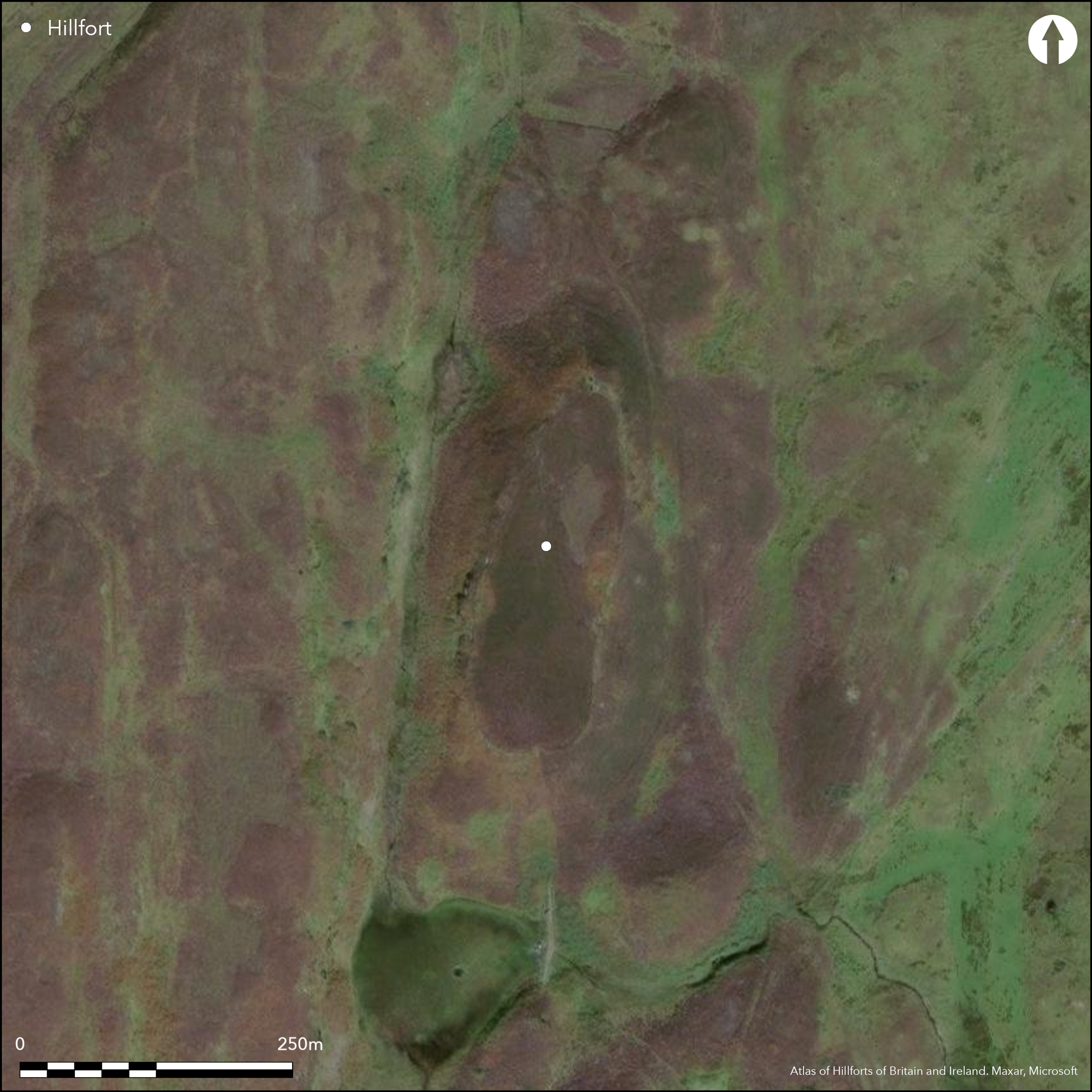
This fort occupies a relatively low but steep sided ridge in the moorland to the W of Ulbster, which rises in a series of such ridges to the larger bulk of Warehouse Hill. Oval on plan, it measures about 180m from NNE to SSW by 55m transversely (0.85ha) within a single stone wall generally some 2.25m thick. Long stretches of the outer face are visible, in one place standing up to 1m in high in six courses. There are entrances on the SSW and NNE, the former 3.3m wide and lined with slabs set on edge, and the latter framed by a remarkable setting of orthostats. Though only three remain, there were evidently four set in pairs to mark the inner and outer ends of the passage through the wall, which at this point swells to a thickness of 4.5m; standing at right-angles to the passage, these massive stones are each about 1.6m high. Other features of the wall noted in 1983 by Roger Mercer include a series of narrow built channels set transversely through the body of the wall (1985, 110-12, figs 69-70), though these have not been noted by other investigators; he also followed Alexander Curle (RCAHMS 1911, 165, no.528) in suggesting that a rectangular structure let into the wall on the E was possibly the remains of a blocked entrance, and interpretation not shared by other investigators, most recently of RCAHMS, who regard this as a later insertion. The peat covered interior is heather-grown, but two collections of stones that may be the remains of small cairns can be seen at the NNE end, where there is also evidence of shallow surface quarrying, while a stony bank defines a small enclosure within the SSW end. In addition to the structure already noted on the E, another small pen has been built against the wall on this side, and a third outside the circuit on the SSW.
Citizen Science: ✗
Reliability of Data: Confirmed
Reliability of Interpretation: Confirmed
X: -353597 Y: 8042382 (EPSG: 3857)
Longitude: -3.176415504420967 Latitude: 58.35555530986021 (EPSG:4326)
Country: Scotland
Current County or Unitary Authority: Highland
Historic County: Caithness
Current Parish/Community/Council/Townland: Wick
None
| Extant | ✓ |
| Cropmark | ✗ |
| Likely Destroyed | ✗ |
None
| Woodland | ✗ |
| Commercial Forestry Plantation | ✗ |
| Parkland | ✗ |
| Pasture (Grazing) | ✓ |
| Arable | ✗ |
| Scrub/Bracken | ✗ |
| Bare Outcrop | ✗ |
| Heather/Moorland | ✓ |
| Heath | ✗ |
| Built-up | ✗ |
| Coastal Grassland | ✗ |
| Other | ✗ |
None
| Contour Fort | ✓ |
| Partial Contour Fort | ✗ |
| Promontory Fort | ✗ |
| Hillslope Fort | ✗ |
| Level Terrain Fort | ✗ |
| Marsh Fort | ✗ |
| Multiple Enclosure Fort | ✗ |
| Hilltop | ✗ |
| Coastal Promontory | ✗ |
| Inland Promontory | ✗ |
| Valley Bottom | ✗ |
| Knoll/Hillock/Outcrop | ✓ |
| Ridge | ✗ |
| Cliff/Plateau-edge/Scarp | ✗ |
| Hillslope | ✗ |
| Lowland | ✗ |
| Spur | ✗ |
Dominant Topographic Feature: None
| North | ✗ |
| Northeast | ✗ |
| East | ✗ |
| Southeast | ✗ |
| South | ✗ |
| Southwest | ✗ |
| West | ✗ |
| Northwest | ✗ |
| Level | ✓ |
Altitude: 125.0m
N/A
In the absence of excavation, there are neither stratified artefacts nor radiocarbon dates to provide a chronology for the defences.
Reliability: D - None
| Pre 1200BC | ✗ |
| 1200BC - 800BC | ✗ |
| 800BC - 400BC | ✗ |
| 400BC - AD50 | ✗ |
| AD50 - AD400 | ✗ |
| AD400 - AD 800 | ✗ |
| Post AD800 | ✗ |
| Unknown | ✓ |
| Pre Hillfort: | None |
| Post Hillfort: | None |
Both RCAHMS and Highland HER hold extensive collections of photographs, in the case of RCAHMS including photographs taken by Alexander Curle in 1910 and recent aerial views.
| 1st Identified Written Reference (1865): | Observations by Joseph Anderson almost certainly relate to his work about 1865 (Anderson 1883, 273-4) |
| 1st Identified Map Depiction (1871): | Annotated Fort on the 1st edition of the OS 25-inch map (Caithness 1877, sheet 29.15) |
| Earthwork Survey (1871): | Survey sketches by Sir Henry Dryden (RCAHMS DC25437, part of SAS 21 ) |
| Other (1910): | Description (RCAHMS 1911, 165, no.528) |
| Other (1935): | First Scheduled probably in 1930s |
| Earthwork Survey (1955): | Plan and description for RCAHMS Survey of Marginal Lands (RCAHMS CAD 3/1 & DP147578; Feahem 1963, 114) |
| Other (1967): | Resurveyed at 1:2500 by the OS |
| Other (1976): | Resurveyed at 1:2500 by the OS |
| Other (1983): | Plan and description by R J Mercer (1985, 110-12, figs 69 -70; RCAHMS DC842) |
| Other (1997): | Visited by the Hill-Fort Study Group |
| Other (2000): | Re-Scheduled |
| Earthwork Survey (2004): | Plan and description by RCAHMS (RCAHMS DC44689 & SC1251103) |
Two possible small cairns, quarrying and a small enclosure
Water currently collects in a shallow depression in the NNE end
| None | ✗ |
| Spring | ✗ |
| Stream | ✗ |
| Pool | ✗ |
| Flush | ✗ |
| Well | ✗ |
| Other | ✓ |
Small u-shaped enclosure
| No Known Features | ✗ |
| Round Stone Structures | ✗ |
| Rectangular Stone Structures | ✗ |
| Curvilinear Platforms | ✗ |
| Other Roundhouse Evidence | ✗ |
| Pits | ✗ |
| Quarry Hollows | ✗ |
| Other | ✓ |
None
| No Known Excavation | ✓ |
| Pits | ✗ |
| Postholes | ✗ |
| Roundhouses | ✗ |
| Rectangular Structures | ✗ |
| Roads/Tracks | ✗ |
| Quarry Hollows | ✗ |
| Other | ✗ |
| Nothing Found | ✗ |
None
| No Known Geophysics | ✓ |
| Pits | ✗ |
| Roundhouses | ✗ |
| Rectangular Structures | ✗ |
| Roads/Tracks | ✗ |
| Quarry Hollows | ✗ |
| Other | ✗ |
| Nothing Found | ✗ |
None
| No Known Finds | ✓ |
| Pottery | ✗ |
| Metal | ✗ |
| Metalworking | ✗ |
| Human Bones | ✗ |
| Animal Bones | ✗ |
| Lithics | ✗ |
| Environmental | ✗ |
| Other | ✗ |
NO APPARENT FEATURES
| APs Not Checked | ✗ |
| None | ✓ |
| Roundhouses | ✗ |
| Rectangular Structures | ✗ |
| Pits | ✗ |
| Postholes | ✗ |
| Roads/Tracks | ✗ |
| Other | ✗ |
See main summary
| 2: | None |
| 2: | None |
Guard Chambers: ✗
Chevaux de Frise: ✗
| 1. Simple Gap (North): | Framed by massive orthostats |
| 2. Simple Gap (South): | None |
Single wall
| Area 1: | 0.8ha. |
| Total: | 0.8ha. |
Total Footprint Area: Noneha.
None
| ✗ | None |
| ✓ | None |
| NE Quadrant: | 1 |
| SE Quadrant: | 1 |
| SW Quadrant: | 1 |
| NW Quadrant: | 1 |
| Total: | 1 |
| Partial Univallate | ✗ |
| Univallate | ✓ |
| Partial Bivallate | ✗ |
| Bivallate | ✗ |
| Partial Multivallate | ✗ |
| Multivallate | ✗ |
| Unknown | ✗ |
| Partial Univallate | ✗ |
| Univallate | ✗ |
| Partial Bivallate | ✗ |
| Bivallate | ✗ |
| Partial Multivallate | ✗ |
| Multivallate | ✗ |
None
| None | ✗ |
| Earthen Bank | ✗ |
| Stone Wall | ✓ |
| Rubble | ✗ |
| Wall-walk | ✗ |
| Evidence of Timber | ✗ |
| Vitrification | ✗ |
| Other Burning | ✗ |
| Palisade | ✗ |
| Counter Scarp Bank | ✗ |
| Berm | ✗ |
| Unfinished | ✗ |
| Other | ✗ |
None
| None | ✗ |
| Earthen Bank | ✗ |
| Stone Wall | ✗ |
| Murus Duplex | ✗ |
| Timber-framed | ✗ |
| Timber-laced | ✗ |
| Vitrification | ✗ |
| Other Burning | ✗ |
| Palisade | ✗ |
| Counter Scarp Bank | ✗ |
| Berm | ✗ |
| Unfinished | ✗ |
| No Known Excavation | ✓ |
| Other | ✗ |
| ✗ | None |
| ✗ | None |
Number of Ditches: None
| ✗ | None |
Anderson, J (1883a) Scotland in pagan times: the iron age: the Rhind lectures in archaeology for 1881. Edinburgh
Feachem, R (1963) A guide to prehistoric Scotland. Batsford: London
Mercer, R J (1985) Archaeological Field Survey in Northern Scotland Volume III 1982-1983. University of Edinburgh, Department of Archaeology, Occasional Paper No. 11. Edinburgh
RCAHMS (1911) The Royal Commission on the Ancient and Historical Monuments and Constructions of Scotland. Third report and inventory of monuments and constructions in the county of Caithness. HMSO, London
Atlas of Hillforts:
Wikidata:
This work is licensed under CC BY-SA 4.0![]()
![]()
![]() and should be cited as:
and should be cited as:
Lock, Gary and Ralston, Ian. 2024. Atlas of Hillforts of Britain and Ireland. Available at: https://hillforts.arch.ox.ac.uk
Document Version 1.1