Satellite Imagery
Satellite Imagery
HER: Orkney Islands 1693 (None)
NMR: HY 21 NW 7 (1693)
SM: 6214
NGR: HY 2194 1574
X: 321940 Y: 1015740 (OSGB36)
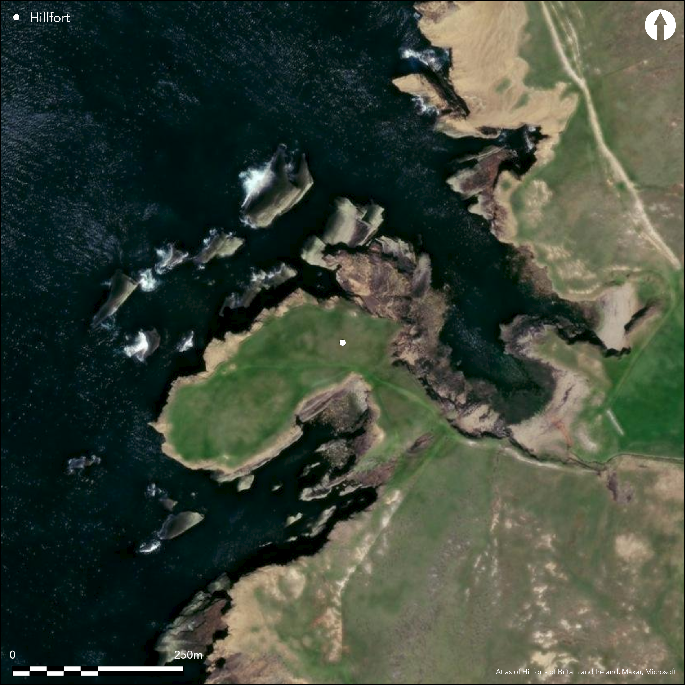
This fort occupies a cliff-girt promontory which has almost been reduced to an isolated stack by the erosion of the narrow neck linking its NW end to the mainland. Some 60m long, this neck is now no more than 25m wide at its seaward end, where a wall reduced to a bank about 4m in thickness by 0.5m in height cuts across its spine behind a shallow natural depression. At the landward end of the neck on the SE a deep natural gully that descends almost to the level of the shore has been adopted as a ditch outside a second wall, which has again been reduced to little more than a grass-grown bank and measures up to 5m in thickness by 0.4m in height. Another bank on the landward lip of the gully may be the remains of an additional rampart, though Raymond Lamb thought this was the remains of a later wall associated with a rectangular building at its NE end (1980, 77). The exact position of the entrance through the defences is uncertain; Lamb again thought there was a gap in the centre of the inner (1980, 22, fig 7), but the upright slabs the OS surveyor interpreted as part of a gatehouse or forework in front of it have been identified more recently by RCAHMS investigators as the remains of a rectangular building and the gap may be no more than disturbance. Both Lamb and the OS surveyor placed the entrance through the second wall in a gap towards its NE end. The interior is largely featureless, measuring about 180m from NE to SW by 75m transversely (1.21ha), rising westwards to a broad summit surmounted by a marker cairn and a modern drystone enclosure, but a small structure with two kerbstones can be seen in the cliff-edge 20m SW of the modern marker cairn on its summit. This was interpreted by the RCAHMS investigators as the remains of a cairn and geophysical survey by Orkney College revealed anomalies here and where burnt material was observed eroding out of the cliff.
Citizen Science: ✗
Reliability of Data: Confirmed
Reliability of Interpretation: Confirmed
X: -374178 Y: 8185071 (EPSG: 3857)
Longitude: -3.361297832334414 Latitude: 59.02166388108677 (EPSG:4326)
Country: Scotland
Current County or Unitary Authority: Orkney Islands
Historic County: Orkney
Current Parish/Community/Council/Townland: Sandwick
None
| Extant | ✓ |
| Cropmark | ✗ |
| Likely Destroyed | ✗ |
None
| Woodland | ✗ |
| Commercial Forestry Plantation | ✗ |
| Parkland | ✗ |
| Pasture (Grazing) | ✓ |
| Arable | ✗ |
| Scrub/Bracken | ✗ |
| Bare Outcrop | ✗ |
| Heather/Moorland | ✓ |
| Heath | ✗ |
| Built-up | ✗ |
| Coastal Grassland | ✓ |
| Other | ✗ |
None
| Contour Fort | ✗ |
| Partial Contour Fort | ✗ |
| Promontory Fort | ✓ |
| Hillslope Fort | ✗ |
| Level Terrain Fort | ✗ |
| Marsh Fort | ✗ |
| Multiple Enclosure Fort | ✗ |
| Hilltop | ✗ |
| Coastal Promontory | ✓ |
| Inland Promontory | ✗ |
| Valley Bottom | ✗ |
| Knoll/Hillock/Outcrop | ✗ |
| Ridge | ✗ |
| Cliff/Plateau-edge/Scarp | ✗ |
| Hillslope | ✗ |
| Lowland | ✗ |
| Spur | ✗ |
Dominant Topographic Feature: None
| North | ✗ |
| Northeast | ✗ |
| East | ✗ |
| Southeast | ✗ |
| South | ✗ |
| Southwest | ✗ |
| West | ✗ |
| Northwest | ✗ |
| Level | ✓ |
Altitude: 30.0m
N/A
In the absence of excavation, there are neither stratified artefacts nor radiocarbon dates to provide a chronology for the defences.
Reliability: D - None
| Pre 1200BC | ✗ |
| 1200BC - 800BC | ✗ |
| 800BC - 400BC | ✗ |
| 400BC - AD50 | ✗ |
| AD50 - AD400 | ✗ |
| AD400 - AD 800 | ✗ |
| Post AD800 | ✗ |
| Unknown | ✓ |
| Pre Hillfort: | None |
| Post Hillfort: | None |
Named on the 1st edition OS 6-inch map (Orkney 1880, sheet 100), but not as an antiquity. Photographed by RCAHMS Aerial Survey Programme in 2009.
| 1st Identified Written Reference (1841): | Noted (NSA, 15, Orkney, 54) |
| Other (1928): | Description (RCAHMS 1946, ii, 269, no.730) |
| Earthwork Survey (1970): | Description by Raymond Lamb (1980, 22 fig 7, 77; RCAHMS ORD 197/1) |
| 1st Identified Map Depiction (1973): | Surveyed at 1:2500 by the OS |
| Other (1981): | Revisited and photographed by Lamb |
| Geophysical Survey (2010): | By Orkney College (Moore 2010) |
| Other (2013): | Description by RCAHMS |
| Other (2014): | Scheduled |
Largely featureless apart from the structure with two kerbstones
None
| None | ✓ |
| Spring | ✗ |
| Stream | ✗ |
| Pool | ✗ |
| Flush | ✗ |
| Well | ✗ |
| Other | ✗ |
Small kerbed structure
| No Known Features | ✗ |
| Round Stone Structures | ✗ |
| Rectangular Stone Structures | ✗ |
| Curvilinear Platforms | ✗ |
| Other Roundhouse Evidence | ✗ |
| Pits | ✗ |
| Quarry Hollows | ✗ |
| Other | ✓ |
None
| No Known Excavation | ✓ |
| Pits | ✗ |
| Postholes | ✗ |
| Roundhouses | ✗ |
| Rectangular Structures | ✗ |
| Roads/Tracks | ✗ |
| Quarry Hollows | ✗ |
| Other | ✗ |
| Nothing Found | ✗ |
several minor anomalies
| No Known Geophysics | ✗ |
| Pits | ✗ |
| Roundhouses | ✗ |
| Rectangular Structures | ✗ |
| Roads/Tracks | ✗ |
| Quarry Hollows | ✗ |
| Other | ✓ |
| Nothing Found | ✗ |
None
| No Known Finds | ✓ |
| Pottery | ✗ |
| Metal | ✗ |
| Metalworking | ✗ |
| Human Bones | ✗ |
| Animal Bones | ✗ |
| Lithics | ✗ |
| Environmental | ✗ |
| Other | ✗ |
NO APPARENT FEATURES
| APs Not Checked | ✗ |
| None | ✓ |
| Roundhouses | ✗ |
| Rectangular Structures | ✗ |
| Pits | ✗ |
| Postholes | ✗ |
| Roads/Tracks | ✗ |
| Other | ✗ |
See main summary
| 1: | None |
| 2: | Must be across the isthmus on the SE |
Guard Chambers: ✗
Chevaux de Frise: ✗
| 1. Simple Gap (South east): | Through outer wall |
At least two walls cutting off a promontory, possibly representing two separate periods of enclosure
| Area 1: | 1.21ha. |
| Area 2: | 1.41ha. |
| Total: | 1.41ha. |
Total Footprint Area: 1.41ha.
None
| ✗ | None |
| ✗ | None |
| NE Quadrant: | 0 |
| SE Quadrant: | 2 |
| SW Quadrant: | 0 |
| NW Quadrant: | 0 |
| Total: | 2 |
| Partial Univallate | ✗ |
| Univallate | ✗ |
| Partial Bivallate | ✓ |
| Bivallate | ✗ |
| Partial Multivallate | ✗ |
| Multivallate | ✗ |
| Unknown | ✗ |
| Partial Univallate | ✗ |
| Univallate | ✗ |
| Partial Bivallate | ✗ |
| Bivallate | ✗ |
| Partial Multivallate | ✗ |
| Multivallate | ✗ |
None
| None | ✗ |
| Earthen Bank | ✗ |
| Stone Wall | ✓ |
| Rubble | ✗ |
| Wall-walk | ✗ |
| Evidence of Timber | ✗ |
| Vitrification | ✗ |
| Other Burning | ✗ |
| Palisade | ✗ |
| Counter Scarp Bank | ✗ |
| Berm | ✗ |
| Unfinished | ✗ |
| Other | ✗ |
None
| None | ✗ |
| Earthen Bank | ✗ |
| Stone Wall | ✗ |
| Murus Duplex | ✗ |
| Timber-framed | ✗ |
| Timber-laced | ✗ |
| Vitrification | ✗ |
| Other Burning | ✗ |
| Palisade | ✗ |
| Counter Scarp Bank | ✗ |
| Berm | ✗ |
| Unfinished | ✗ |
| No Known Excavation | ✓ |
| Other | ✗ |
| ✗ | None |
| ✗ | None |
Number of Ditches: None
| ✗ | None |
Lamb, R G (1980) Iron Age promontory forts in the Northern Isles. Brit Archaeol Rep, British Ser 79. BAR: Oxford
Moore, J (2010) 'Brough of Bigging, Orkney (Sandwick parish), geophysical survey'. Disc Exc Scot, New Ser, 11 (2010), 126
NSA (1834-1845) The New Statistical Account of Scotland by the ministers of the respective parishes under the superintendence of a committee of the society for the benefit of the sons and daughters of the clergy, 15v. Edinburgh
RCAHMS (1946) The Royal Commission on the Ancient and Historical Monuments of Scotland. Twelfth report with an inventory of the ancient monuments of Orkney and Shetland, 3v. HMSO: Edinburgh
Atlas of Hillforts:
Wikidata:
This work is licensed under CC BY-SA 4.0![]()
![]()
![]() and should be cited as:
and should be cited as:
Lock, Gary and Ralston, Ian. 2024. Atlas of Hillforts of Britain and Ireland. Available at: https://hillforts.arch.ox.ac.uk
Document Version 1.1