Satellite Imagery
Satellite Imagery
HER: Orkney Islands 1710 (None)
NMR: HY 21 SE 22 (1710)
SM: 5871
NGR: HY 2828 1179
X: 328284 Y: 1011791 (OSGB36)
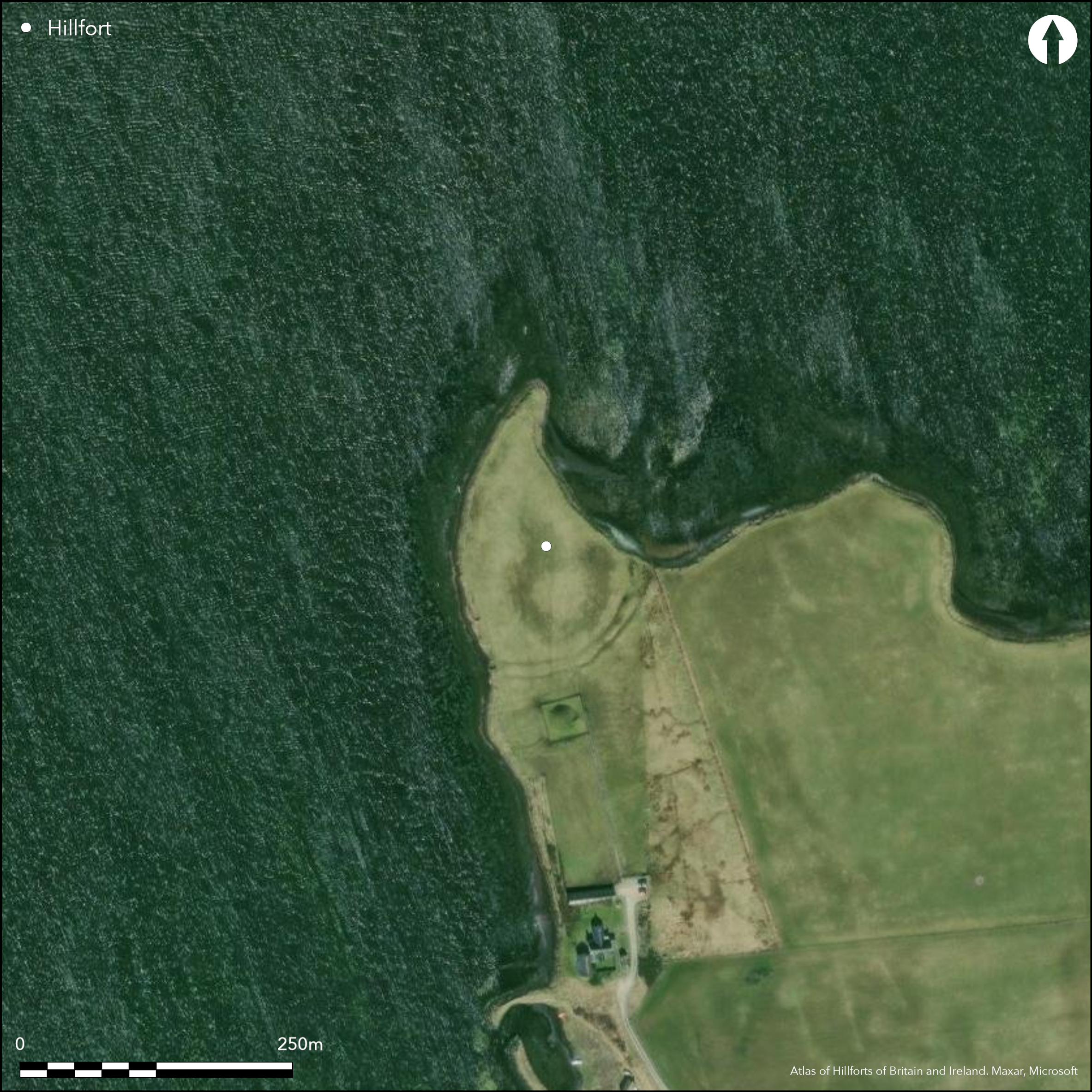
An earthwork comprising twin concentric ditches and banks is drawn in a regular arc across the low-lying tip of Onston Point. The ditches are both about 3m broad, lying to either side of a low medial bank about 0.6m high, and the second low bank stands on the counterscarp of the outer ditch. There are several gaps along its line, but aerial photographs suggest a slight misalignment to either side of one 40m E of the W shore, perhaps indicating this is original, though the OS surveyor in 1966 suggested there was an entrance causeway near the NE shore. The roughly triangular interior is featureless and measures 130m from N to S, tapering from a maximum 80m transversely immediately to the rear of the earthwork to a point in the shallows of the loch (0.66ha). At the NE end of the perimeter, however, aerial photographs also show traces of a line of stones extending N in a straight line for a distance of at least 60m beneath the water, possibly indicating that the enclosed area on dryland was once considerably larger. The date and purpose of this promontory work are unknown.
Citizen Science: ✗
Reliability of Data: Confirmed
Reliability of Interpretation: Confirmed
X: -361738 Y: 8177647 (EPSG: 3857)
Longitude: -3.24954857430822 Latitude: 58.987321466960424 (EPSG:4326)
Country: Scotland
Current County or Unitary Authority: Orkney Islands
Historic County: Orkney
Current Parish/Community/Council/Townland: Stenness
None
| Extant | ✓ |
| Cropmark | ✗ |
| Likely Destroyed | ✗ |
None
| Woodland | ✗ |
| Commercial Forestry Plantation | ✗ |
| Parkland | ✗ |
| Pasture (Grazing) | ✓ |
| Arable | ✗ |
| Scrub/Bracken | ✗ |
| Bare Outcrop | ✗ |
| Heather/Moorland | ✗ |
| Heath | ✗ |
| Built-up | ✗ |
| Coastal Grassland | ✓ |
| Other | ✗ |
None
| Contour Fort | ✗ |
| Partial Contour Fort | ✗ |
| Promontory Fort | ✓ |
| Hillslope Fort | ✗ |
| Level Terrain Fort | ✗ |
| Marsh Fort | ✗ |
| Multiple Enclosure Fort | ✗ |
| Hilltop | ✗ |
| Coastal Promontory | ✓ |
| Inland Promontory | ✗ |
| Valley Bottom | ✗ |
| Knoll/Hillock/Outcrop | ✗ |
| Ridge | ✗ |
| Cliff/Plateau-edge/Scarp | ✗ |
| Hillslope | ✗ |
| Lowland | ✗ |
| Spur | ✗ |
Dominant Topographic Feature: None
| North | ✗ |
| Northeast | ✗ |
| East | ✗ |
| Southeast | ✗ |
| South | ✗ |
| Southwest | ✗ |
| West | ✗ |
| Northwest | ✗ |
| Level | ✓ |
Altitude: 5.0m
N/A
In the absence of modern excavation, there are neither stratified artefacts nor radiocarbon dates to provide a chronology for the defences.
Reliability: D - None
| Pre 1200BC | ✗ |
| 1200BC - 800BC | ✗ |
| 800BC - 400BC | ✗ |
| 400BC - AD50 | ✗ |
| AD50 - AD400 | ✗ |
| AD400 - AD 800 | ✗ |
| Post AD800 | ✗ |
| Unknown | ✓ |
| Pre Hillfort: | None |
| Post Hillfort: | None |
None
| 1st Identified Written Reference (1907): | First noted in The Orcadian 19 Oct 1907 |
| Earthwork Survey (1928): | Plan and description (RCAHMS 1946, ii, 298, no.873, fig 373; ORD 62/1-2) |
| Excavation (1960): | Trench by FT Wainwright (Lamb 1980, 78) |
| Other (1966): | Surveyed at 1:2500 by the OS |
| Other (1970): | Description by Raymond Lamb (1980, 78) |
| Other (1994): | Scheduled |
| Geophysical Survey (2007): | Geophysics Unit, Orkney College |
Featureless
None
| None | ✓ |
| Spring | ✗ |
| Stream | ✗ |
| Pool | ✗ |
| Flush | ✗ |
| Well | ✗ |
| Other | ✗ |
None
| No Known Features | ✓ |
| Round Stone Structures | ✗ |
| Rectangular Stone Structures | ✗ |
| Curvilinear Platforms | ✗ |
| Other Roundhouse Evidence | ✗ |
| Pits | ✗ |
| Quarry Hollows | ✗ |
| Other | ✗ |
None
| No Known Excavation | ✓ |
| Pits | ✗ |
| Postholes | ✗ |
| Roundhouses | ✗ |
| Rectangular Structures | ✗ |
| Roads/Tracks | ✗ |
| Quarry Hollows | ✗ |
| Other | ✗ |
| Nothing Found | ✗ |
None
| No Known Geophysics | ✗ |
| Pits | ✗ |
| Roundhouses | ✗ |
| Rectangular Structures | ✗ |
| Roads/Tracks | ✗ |
| Quarry Hollows | ✗ |
| Other | ✗ |
| Nothing Found | ✓ |
None
| No Known Finds | ✓ |
| Pottery | ✗ |
| Metal | ✗ |
| Metalworking | ✗ |
| Human Bones | ✗ |
| Animal Bones | ✗ |
| Lithics | ✗ |
| Environmental | ✗ |
| Other | ✗ |
NO APPARENT FEATURES
| APs Not Checked | ✗ |
| None | ✓ |
| Roundhouses | ✗ |
| Rectangular Structures | ✗ |
| Pits | ✗ |
| Postholes | ✗ |
| Roads/Tracks | ✗ |
| Other | ✗ |
See main summary
| 2: | None |
| 2: | None |
Guard Chambers: ✗
Chevaux de Frise: ✗
| 1. Simple Gap (South): | Misalignment of particularly the outer ditch |
| 2. Simple Gap (South east): | Causeway |
Two ditches with external banks cutting off a promontory
| Area 1: | 0.66ha. |
| Total: | 0.66ha. |
Total Footprint Area: Noneha.
None
| ✗ | None |
| ✗ | None |
| NE Quadrant: | 0 |
| SE Quadrant: | 2 |
| SW Quadrant: | 0 |
| NW Quadrant: | 0 |
| Total: | 2 |
| Partial Univallate | ✗ |
| Univallate | ✗ |
| Partial Bivallate | ✓ |
| Bivallate | ✗ |
| Partial Multivallate | ✗ |
| Multivallate | ✗ |
| Unknown | ✗ |
| Partial Univallate | ✗ |
| Univallate | ✗ |
| Partial Bivallate | ✗ |
| Bivallate | ✗ |
| Partial Multivallate | ✗ |
| Multivallate | ✗ |
None
| None | ✗ |
| Earthen Bank | ✓ |
| Stone Wall | ✗ |
| Rubble | ✗ |
| Wall-walk | ✗ |
| Evidence of Timber | ✗ |
| Vitrification | ✗ |
| Other Burning | ✗ |
| Palisade | ✗ |
| Counter Scarp Bank | ✗ |
| Berm | ✗ |
| Unfinished | ✗ |
| Other | ✗ |
None
| None | ✗ |
| Earthen Bank | ✓ |
| Stone Wall | ✓ |
| Murus Duplex | ✗ |
| Timber-framed | ✗ |
| Timber-laced | ✗ |
| Vitrification | ✗ |
| Other Burning | ✗ |
| Palisade | ✗ |
| Counter Scarp Bank | ✗ |
| Berm | ✗ |
| Unfinished | ✗ |
| No Known Excavation | ✗ |
| Other | ✗ |
| ✗ | None |
| ✓ | None |
Number of Ditches: 2
| ✗ | None |
Lamb, R G (1980) Iron Age promontory forts in the Northern Isles. Brit Archaeol Rep, British Ser 79. BAR: Oxford
RCAHMS (1946) The Royal Commission on the Ancient and Historical Monuments of Scotland. Twelfth report with an inventory of the ancient monuments of Orkney and Shetland, 3v. HMSO: Edinburgh
Atlas of Hillforts:
Wikidata:
This work is licensed under CC BY-SA 4.0![]()
![]()
![]() and should be cited as:
and should be cited as:
Lock, Gary and Ralston, Ian. 2024. Atlas of Hillforts of Britain and Ireland. Available at: https://hillforts.arch.ox.ac.uk
Document Version 1.1