Satellite Imagery
Satellite Imagery
HER: Orkney Islands 1660 (None)
NMR: HY 21 NW 1 (1660)
SM: 1418
NGR: HY 2241 1678
X: 322410 Y: 1016780 (OSGB36)
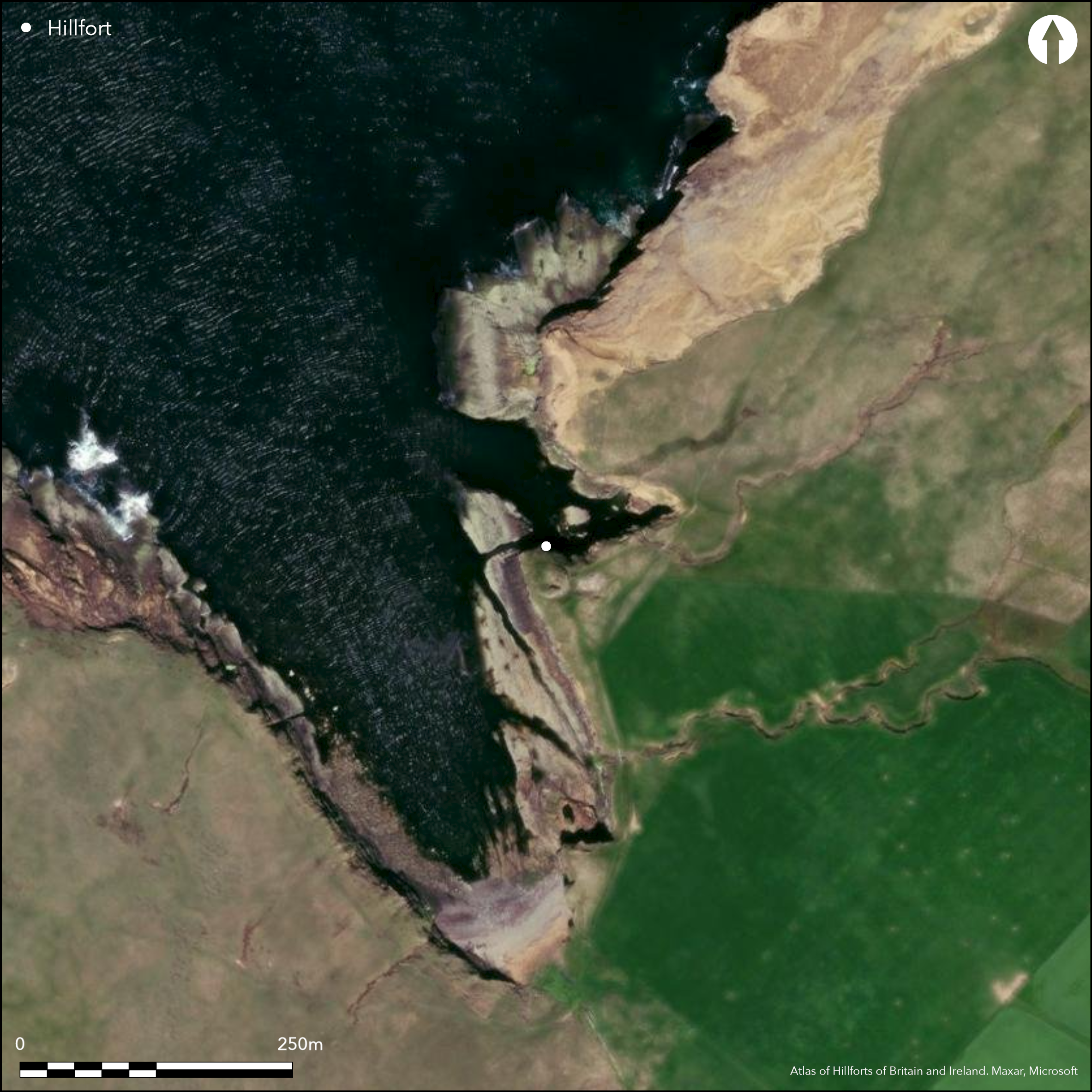
The Broch of Borwick is at first sight the stump of a relatively well-preserved broch standing spectacularly at the tip of a precipitous promontory, but it has not only suffered at the hands of an antiquarian excavator, and the cliff-faces are steadily receding on the N and SW where the wall is collapsing into the abyss. The broch measures about 8.2m in diameter within a wall between 3.5m and 4.6m in thickness and still presents up to 2.4m of neatly coursed outer face to either side of its checked entrance on the SE, which also has a guard chamber. There was evidently a settlement outside the broch, but it is difficult to make any sense of the remains visible today, and nor of any other defences barring access on the landward side. Nevertheless, in the account of his excavations, in which he dug down through a mound over 6m high, William Watt describes an outer wall cutting off the promontory that was 1.8m thick at the base and tapered upwards to about 1m at a height of 2.7m. Confusingly he asserts that this wall was 'founded in the moat' (Watt 1882, 447) 15m to 18m broad that he believed also traversed the approaches to the promontory, of which little coherent trace can now be seen. The enclosed area was roughly triangular, measuring perhaps 50m from NE to SW immediately to the rear of the wall by at least 40m transversely (0.11ha).
Citizen Science: ✗
Reliability of Data: Confirmed
Reliability of Interpretation: Unconfirmed
X: -373308 Y: 8187109 (EPSG: 3857)
Longitude: -3.3534811877037134 Latitude: 59.03108673891024 (EPSG:4326)
Country: Scotland
Current County or Unitary Authority: Orkney Islands
Historic County: Orkney
Current Parish/Community/Council/Townland: Sandwick
Heavy erosion now eating into the broch
| Extant | ✓ |
| Cropmark | ✗ |
| Likely Destroyed | ✓ |
None
| Woodland | ✗ |
| Commercial Forestry Plantation | ✗ |
| Parkland | ✗ |
| Pasture (Grazing) | ✗ |
| Arable | ✗ |
| Scrub/Bracken | ✗ |
| Bare Outcrop | ✗ |
| Heather/Moorland | ✗ |
| Heath | ✗ |
| Built-up | ✗ |
| Coastal Grassland | ✓ |
| Other | ✗ |
None
| Contour Fort | ✗ |
| Partial Contour Fort | ✗ |
| Promontory Fort | ✓ |
| Hillslope Fort | ✗ |
| Level Terrain Fort | ✗ |
| Marsh Fort | ✗ |
| Multiple Enclosure Fort | ✗ |
| Hilltop | ✗ |
| Coastal Promontory | ✓ |
| Inland Promontory | ✗ |
| Valley Bottom | ✗ |
| Knoll/Hillock/Outcrop | ✗ |
| Ridge | ✗ |
| Cliff/Plateau-edge/Scarp | ✗ |
| Hillslope | ✗ |
| Lowland | ✗ |
| Spur | ✗ |
Dominant Topographic Feature: None
| North | ✗ |
| Northeast | ✗ |
| East | ✗ |
| Southeast | ✗ |
| South | ✗ |
| Southwest | ✗ |
| West | ✗ |
| Northwest | ✗ |
| Level | ✓ |
Altitude: 25.0m
N/A
No distinctive finds from the excavations
Reliability: D - None
| Pre 1200BC | ✗ |
| 1200BC - 800BC | ✗ |
| 800BC - 400BC | ✗ |
| 400BC - AD50 | ✗ |
| AD50 - AD400 | ✗ |
| AD400 - AD 800 | ✗ |
| Post AD800 | ✗ |
| Unknown | ✓ |
| Pre Hillfort: | None |
| Post Hillfort: | None |
None
| 1st Identified Map Depiction (1880): | Named in Gothic type on the 1st edition OS 25-inch map (Orkney 1882, sheet 100.2) |
| Excavation (1881): | by William Watt (1882) |
| Earthwork Survey (1928): | Plan and description (RCAHMS 1946, ii, 252-3, no.679, fig 347; RCAHMS ORD 10/1-2) |
| Other (1935): | Further fieldwork by RCAHMS (1946, 252-3, no.679) |
| Other (1966): | Visited by the OS |
| Other (1975): | Scheduled |
| Other (1983): | eroding midden and other remains observed (Lynn and Bell 1983) |
| Other (1985): | Description by Eaun MacKie (2002, 217) |
| Other (1987): | eroding midden and other remains observed (Lynn and Bell 1987) |
| Geophysical Survey (2011): | Of environs reveals extensive anthropogenic soils (Moore 2011) |
The broch and other structures
None
| None | ✓ |
| Spring | ✗ |
| Stream | ✗ |
| Pool | ✗ |
| Flush | ✗ |
| Well | ✗ |
| Other | ✗ |
Incoherent remains of multiple structures and the broch
| No Known Features | ✗ |
| Round Stone Structures | ✗ |
| Rectangular Stone Structures | ✗ |
| Curvilinear Platforms | ✗ |
| Other Roundhouse Evidence | ✗ |
| Pits | ✗ |
| Quarry Hollows | ✗ |
| Other | ✓ |
The broch and fragments of other structures, apparently including a lintelled passage
| No Known Excavation | ✗ |
| Pits | ✗ |
| Postholes | ✗ |
| Roundhouses | ✗ |
| Rectangular Structures | ✗ |
| Roads/Tracks | ✗ |
| Quarry Hollows | ✗ |
| Other | ✓ |
| Nothing Found | ✗ |
None
| No Known Geophysics | ✓ |
| Pits | ✗ |
| Roundhouses | ✗ |
| Rectangular Structures | ✗ |
| Roads/Tracks | ✗ |
| Quarry Hollows | ✗ |
| Other | ✗ |
| Nothing Found | ✗ |
Assemblage includes: two long- handled bone combs; one composite, single-edged round-backed comb, 1 single-edged non-composite comb, one broken double-edged composite comb; one small whale vertebra cup; a socketed handle; three needles; a spindle whorl; a cetacean ivory toggle and a possible antler bridle cheek-piece. Stone objects include: some thin, round stone discs, probably pot lids; a polished gaming piece; a possible stone lamp; a perforated whetstone; hammerstones; Skaill knives and choppers; and querns. An iron rod was found and a single sherd of pottey. Ongoing erosion has led to the recovery of more pottery and midden (Now in Tankerness Museum; Lynn and Bell 1983; 1987)
| No Known Finds | ✗ |
| Pottery | ✓ |
| Metal | ✓ |
| Metalworking | ✗ |
| Human Bones | ✗ |
| Animal Bones | ✓ |
| Lithics | ✓ |
| Environmental | ✗ |
| Other | ✗ |
NO APPARENT FEATURES
| APs Not Checked | ✗ |
| None | ✓ |
| Roundhouses | ✗ |
| Rectangular Structures | ✗ |
| Pits | ✗ |
| Postholes | ✗ |
| Roads/Tracks | ✗ |
| Other | ✗ |
None known
| 0: | None |
| 2: | No entrance is known through the outer wall |
Guard Chambers: ✗
Chevaux de Frise: ✗
Single wall across a promontory, possibly accompanied by a ditch.
| Area 1: | 0.11ha. |
| Total: | 0.11ha. |
Total Footprint Area: Noneha.
None
| ✗ | None |
| ✗ | None |
| NE Quadrant: | 0 |
| SE Quadrant: | 1 |
| SW Quadrant: | 0 |
| NW Quadrant: | 0 |
| Total: | 1 |
| Partial Univallate | ✓ |
| Univallate | ✗ |
| Partial Bivallate | ✗ |
| Bivallate | ✗ |
| Partial Multivallate | ✗ |
| Multivallate | ✗ |
| Unknown | ✗ |
| Partial Univallate | ✗ |
| Univallate | ✗ |
| Partial Bivallate | ✗ |
| Bivallate | ✗ |
| Partial Multivallate | ✗ |
| Multivallate | ✗ |
None
| None | ✗ |
| Earthen Bank | ✗ |
| Stone Wall | ✓ |
| Rubble | ✗ |
| Wall-walk | ✗ |
| Evidence of Timber | ✗ |
| Vitrification | ✗ |
| Other Burning | ✗ |
| Palisade | ✗ |
| Counter Scarp Bank | ✗ |
| Berm | ✗ |
| Unfinished | ✗ |
| Other | ✗ |
None
| None | ✗ |
| Earthen Bank | ✗ |
| Stone Wall | ✓ |
| Murus Duplex | ✗ |
| Timber-framed | ✗ |
| Timber-laced | ✗ |
| Vitrification | ✗ |
| Other Burning | ✗ |
| Palisade | ✗ |
| Counter Scarp Bank | ✗ |
| Berm | ✗ |
| Unfinished | ✗ |
| No Known Excavation | ✗ |
| Other | ✗ |
| ✗ | None |
| ✗ | Ditch claimed but not wholy convincing |
Number of Ditches: None
| ✗ | None |
Hedges, J W (1987c) Bu, Gurness and the brochs of Orkney, part 3: the brochs of Orkney, Brit Archaeol Rep, BAR British Series 165: Oxford (p 83-5)
Lamb, R G (1980) Iron Age promontory forts in the Northern Isles. Brit Archaeol Rep, British Ser 79. BAR: Oxford
Lynn and Bell, D and B (1983) 'Broch of Borwick (Sandwick p), broch'. Disc Exc Scot (1983), 19
Lynn and Bell, D and B (1987) 'Broch of Borwick (Sandwick parish), pottery and worked bone'. Disc Exc Scot (1987), 34
MacKie, E W (2002) The roundhouses, brochs and wheelhouses of Atlantic Scotland c. 700BC - AD500: architecture and material culture Part 1 - The Orkney and Shetland Isles. BAR British Series 342: Oxford
Moore, J (2011) 'Yesnaby-Skaill Landscape Survey, Orkney (Sandwick parish), walkover and geophysical survey'. Disc Exc Scot, New Ser, 12 (2011), 137
RCAHMS (1946) The Royal Commission on the Ancient and Historical Monuments of Scotland. Twelfth report with an inventory of the ancient monuments of Orkney and Shetland, 3v. HMSO: Edinburgh
Watt, W G T (1882) 'Notice of the broch known as Burwick or Borwick, in the township of Yescanabee and parish of Sandwick, Orkney'. Proc Soc Antiq Scot 16 (1881-2), 442-50
Atlas of Hillforts:
Wikidata:
This work is licensed under CC BY-SA 4.0![]()
![]()
![]() and should be cited as:
and should be cited as:
Lock, Gary and Ralston, Ian. 2024. Atlas of Hillforts of Britain and Ireland. Available at: https://hillforts.arch.ox.ac.uk
Document Version 1.1