Satellite Imagery
Satellite Imagery
HER: Orkney Islands 2201 (None)
NMR: HY 32 NE 5 (2201)
SM: 90157
NGR: HY 3817 2685
X: 338179 Y: 1026850 (OSGB36)
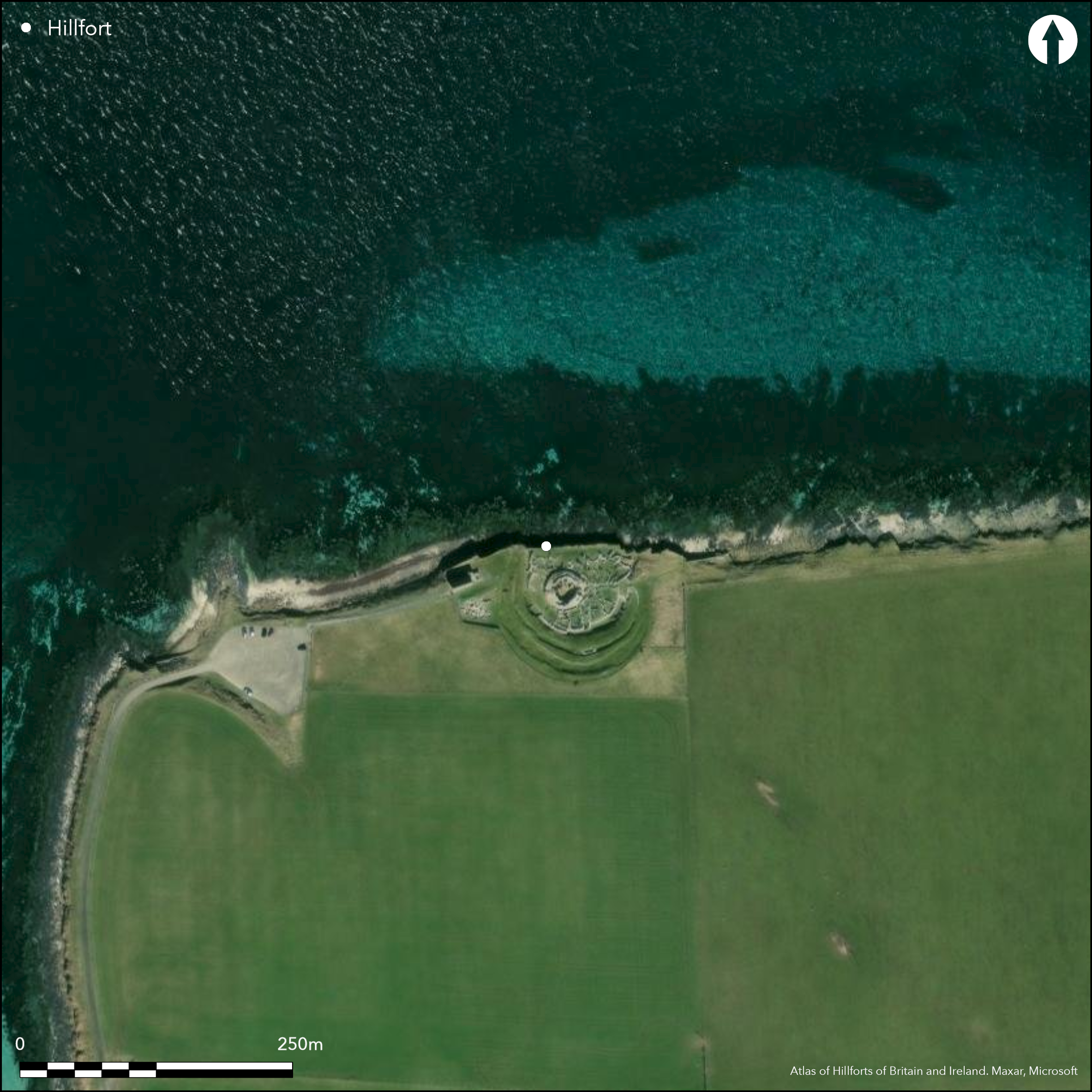
The Broch of Gurness stands at the core of a complex settlement and is encircled by no less than three walls with external ditches. The broch itself measures a little over 10m in diameter within a wall up to 4.4m in thickness and still standing 3.6m in height; it displays numerous architectural features, including guard cells to either side of the checked entrance on the E, mural chambers and galleries, a well, stairways and a scarcement. The surrounding settlement has encroached on the innermost of the outer defences, apparently entailing the demolition of the innermost wall and its replacement by an irregular curtain which in places is founded in the innermost ditch; this latter was up to 8.5m in breadth. The interior of this enclosure measured about 44m from E to W by at least 37m transversely (0.14ha), though it is uncertain how much has been lost along the seaward flank on the N. And while it is often assumed that this inner wall accompanied the erection of the broch, the overall sequence of construction is unknown, and it is equally possible that this once formed a free-standing enclosure. Indeed, so little about the overall sequence is known that it is equally possible that the middle rampart, itself one of the most impressive elements of the defences as they survive today, may once have formed an enclosure in its own right, taking in a rather larger area of about 0.19ha. On the E, however, a passageway led from the broch through the extramural settlement to what must have been an impressive entrance, where the middle and outer walls turned inwards to unite on either side of the gateway. The precise sequence of fortification and occupation here can only be determined by further work.
Citizen Science: ✗
Reliability of Data: Confirmed
Reliability of Interpretation: Unconfirmed
X: -343049 Y: 8207254 (EPSG: 3857)
Longitude: -3.081657584448182 Latitude: 59.124081080055824 (EPSG:4326)
Country: Scotland
Current County or Unitary Authority: Orkney Islands
Historic County: Orkney
Current Parish/Community/Council/Townland: Evie And Rendall
None
| Extant | ✓ |
| Cropmark | ✗ |
| Likely Destroyed | ✗ |
None
| Woodland | ✗ |
| Commercial Forestry Plantation | ✗ |
| Parkland | ✗ |
| Pasture (Grazing) | ✗ |
| Arable | ✗ |
| Scrub/Bracken | ✗ |
| Bare Outcrop | ✗ |
| Heather/Moorland | ✗ |
| Heath | ✗ |
| Built-up | ✗ |
| Coastal Grassland | ✓ |
| Other | ✗ |
None
| Contour Fort | ✗ |
| Partial Contour Fort | ✗ |
| Promontory Fort | ✗ |
| Hillslope Fort | ✗ |
| Level Terrain Fort | ✓ |
| Marsh Fort | ✗ |
| Multiple Enclosure Fort | ✗ |
| Hilltop | ✗ |
| Coastal Promontory | ✗ |
| Inland Promontory | ✗ |
| Valley Bottom | ✗ |
| Knoll/Hillock/Outcrop | ✗ |
| Ridge | ✗ |
| Cliff/Plateau-edge/Scarp | ✓ |
| Hillslope | ✗ |
| Lowland | ✗ |
| Spur | ✗ |
Dominant Topographic Feature: None
| North | ✗ |
| Northeast | ✗ |
| East | ✗ |
| Southeast | ✗ |
| South | ✗ |
| Southwest | ✗ |
| West | ✗ |
| Northwest | ✗ |
| Level | ✓ |
Altitude: 5.0m
N/A
Despite the extensive excavations the overall chronology of the defences here is poorly undestood
Reliability: C - Low
| Pre 1200BC | ✗ |
| 1200BC - 800BC | ✗ |
| 800BC - 400BC | ✗ |
| 400BC - AD50 | ✓ |
| AD50 - AD400 | ✓ |
| AD400 - AD 800 | ✓ |
| Post AD800 | ✗ |
| Unknown | ✓ |
| Pre Hillfort: | None |
| Post Hillfort: | Conceivably the broch and subsequent settlement |
| Artefactual: | None |
Archive from the excavations held in RCAHMS. Other material includes aerial photographs.
| 1st Identified Map Depiction (1879): | Named in Gothic type on the 1st edition OS 25-inch map (Orkney 1882, sheet 89.12) |
| Excavation (1929): | Trial by Mr Robert Rendall |
| Excavation (1930): | By the Society of Antiquaries of Scotland |
| Other (1931): | Guardianship |
| Excavation (1931): | Hedges 1987 |
| Excavation (1932): | Hedges 1987 |
| Excavation (1933): | Hedges 1987 |
| Excavation (1934): | Hedges 1987 |
| Excavation (1935): | Hedges 1987 |
| Excavation (1936): | Hedges 1987 |
| Excavation (1937): | Hedges 1987 |
| Excavation (1938): | Hedges 1987 |
| Excavation (1939): | Hedges 1987. Account of the excavations contributed by J S Richardson to the RCAHMS County Inventory (RCAHMS 1946, ii, 75-9, no.263, figs 127-32) |
| Other (1970): | Resurveyed at 1:2500 by the OS |
| Other (1994): | Scheduled |
| Geophysical Survey (2007): | Across surrounding area (Ovenden 2007) |
Occupied by the broch and surrounding settlement
Within the broch
| None | ✗ |
| Spring | ✗ |
| Stream | ✗ |
| Pool | ✗ |
| Flush | ✗ |
| Well | ✓ |
| Other | ✗ |
Broch
| No Known Features | ✗ |
| Round Stone Structures | ✗ |
| Rectangular Stone Structures | ✗ |
| Curvilinear Platforms | ✗ |
| Other Roundhouse Evidence | ✗ |
| Pits | ✗ |
| Quarry Hollows | ✗ |
| Other | ✓ |
Broch and the later settlement
| No Known Excavation | ✗ |
| Pits | ✗ |
| Postholes | ✗ |
| Roundhouses | ✗ |
| Rectangular Structures | ✗ |
| Roads/Tracks | ✗ |
| Quarry Hollows | ✗ |
| Other | ✓ |
| Nothing Found | ✗ |
None
| No Known Geophysics | ✓ |
| Pits | ✗ |
| Roundhouses | ✗ |
| Rectangular Structures | ✗ |
| Roads/Tracks | ✗ |
| Quarry Hollows | ✗ |
| Other | ✗ |
| Nothing Found | ✗ |
Large assemblage of 850 items, mainly reflecting occupation of the broch and the later settlement.
| No Known Finds | ✗ |
| Pottery | ✓ |
| Metal | ✓ |
| Metalworking | ✓ |
| Human Bones | ✓ |
| Animal Bones | ✓ |
| Lithics | ✓ |
| Environmental | ✗ |
| Other | ✗ |
NO APPARENT FEATURES
| APs Not Checked | ✓ |
| None | ✗ |
| Roundhouses | ✗ |
| Rectangular Structures | ✗ |
| Pits | ✗ |
| Postholes | ✗ |
| Roads/Tracks | ✗ |
| Other | ✗ |
See main summary
| 1: | None |
| 2: | None |
Guard Chambers: ✗
Chevaux de Frise: ✗
| 1. Passage-way/Corridor (East): | None |
Three concentric walls and ditches
| Area 1: | 0.14ha. |
| Area 2: | 0.19ha. |
| Total: | 0.19ha. |
Total Footprint Area: 0.36ha.
None
| ✓ | None |
| ✗ | None |
| NE Quadrant: | 0 |
| SE Quadrant: | 3 |
| SW Quadrant: | 3 |
| NW Quadrant: | 0 |
| Total: | 3 |
| Partial Univallate | ✗ |
| Univallate | ✗ |
| Partial Bivallate | ✗ |
| Bivallate | ✗ |
| Partial Multivallate | ✓ |
| Multivallate | ✗ |
| Unknown | ✗ |
| Partial Univallate | ✗ |
| Univallate | ✗ |
| Partial Bivallate | ✗ |
| Bivallate | ✗ |
| Partial Multivallate | ✗ |
| Multivallate | ✗ |
None
| None | ✗ |
| Earthen Bank | ✗ |
| Stone Wall | ✓ |
| Rubble | ✗ |
| Wall-walk | ✗ |
| Evidence of Timber | ✗ |
| Vitrification | ✗ |
| Other Burning | ✗ |
| Palisade | ✗ |
| Counter Scarp Bank | ✗ |
| Berm | ✗ |
| Unfinished | ✗ |
| Other | ✗ |
None
| None | ✗ |
| Earthen Bank | ✗ |
| Stone Wall | ✓ |
| Murus Duplex | ✗ |
| Timber-framed | ✗ |
| Timber-laced | ✗ |
| Vitrification | ✗ |
| Other Burning | ✗ |
| Palisade | ✗ |
| Counter Scarp Bank | ✗ |
| Berm | ✗ |
| Unfinished | ✗ |
| No Known Excavation | ✗ |
| Other | ✗ |
| ✗ | None |
| ✓ | None |
Number of Ditches: 3
| ✗ | None |
Hedges, J W (1987) Bu, Gurness and the brochs of Orkney, part 2: the brochs of Orkney. Brit Archaeol Rep, British Series 164. BAR: Oxford
MacKie, E W (2002) The roundhouses, brochs and wheelhouses of Atlantic Scotland c. 700BC - AD500: architecture and material culture Part 1 - The Orkney and Shetland Isles. Brit Archaeol Rep, British Ser 342. BAR: Oxford
Ovenden, S (2007) 'Broch of Gurness, Orkney (Evie and Rendall parish), geophysical survey'. Disc Exc Scot, New Ser, 8 (2007), 140
RCAHMS (1946) The Royal Commission on the Ancient and Historical Monuments of Scotland. Twelfth report with an inventory of the ancient monuments of Orkney and Shetland, 3v. HMSO: Edinburgh
Ritchie, A (1995) Prehistoric Orkney. Batsford and Historic Scotland: London (101-8)
Atlas of Hillforts:
Wikidata:
This work is licensed under CC BY-SA 4.0![]()
![]()
![]() and should be cited as:
and should be cited as:
Lock, Gary and Ralston, Ian. 2024. Atlas of Hillforts of Britain and Ireland. Available at: https://hillforts.arch.ox.ac.uk
Document Version 1.1