Satellite Imagery
Satellite Imagery
HER: Highland HER MHG45426 (None)
NMR: NH 19 SW 3 (12142)
SM: 2523
NGR: NH 1423 9135
X: 214230 Y: 891350 (OSGB36)
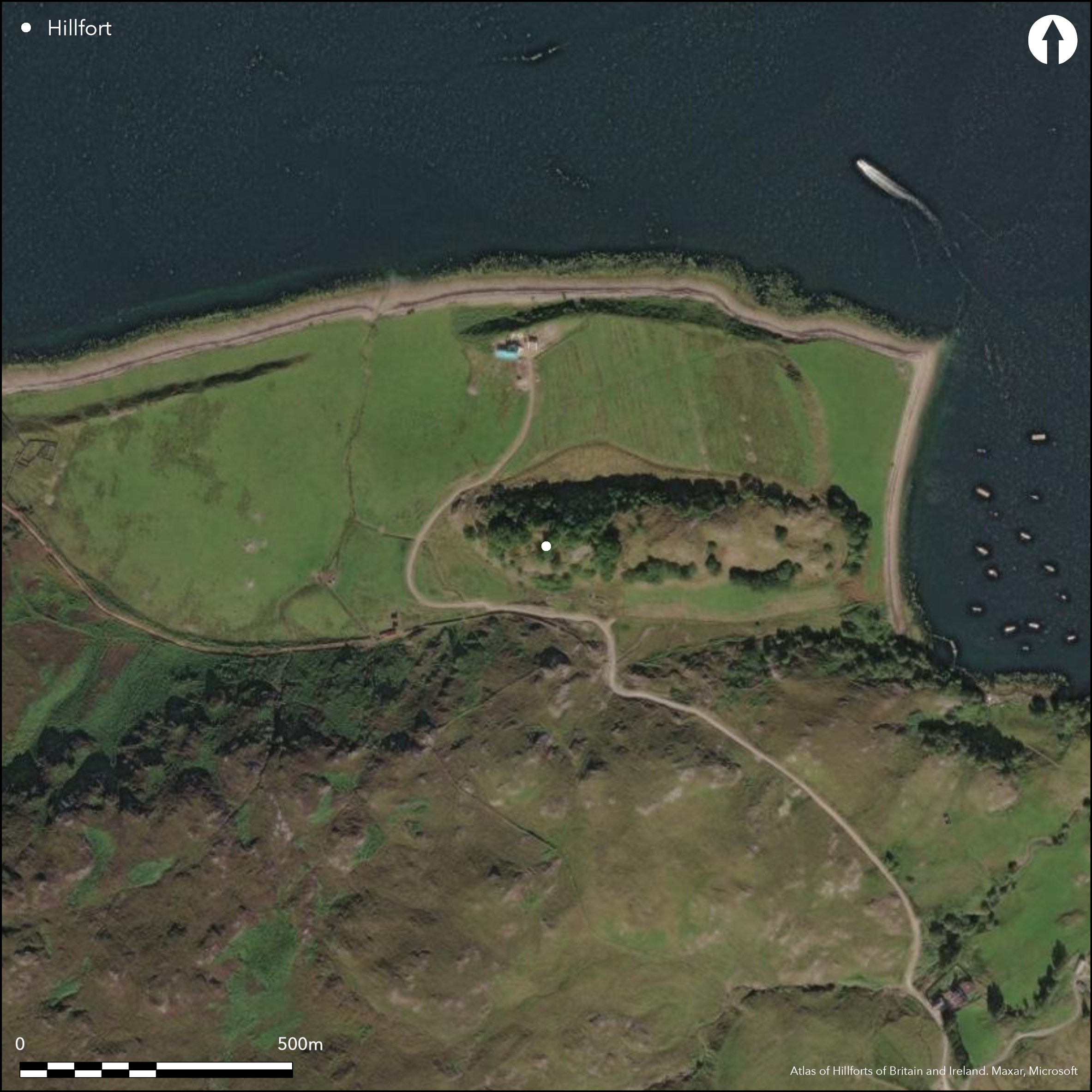
This fort, which is overlain by a broch and latterly utilised for a medieval castle, occupies the elongated crest of a rocky and steep-sided hillock that stands at the foot of the mountain on the SW shore of Loch Broom where it narrows SE of Ullapool. Excavations in 1967-8 by Euan MacKie focused on the broch, which he demonstrated overlay the wall that probably forms the E end of the fort; at this point it measured some 4.5m in thickness and was pierced by an entrance 1.2m to 1.5m wide with a floor of steeply sloping native rock. The wall of the fort here showed no signs of heat or burning, though traces of vitrifaction can be found elsewhere on the circuit at the W end of the fort, and in what seems to be an outer line of defence crossing the ridge to the E; this latter was a timber-laced wall 2.4m thick and the excavation not only exposed large masses of vitrifaction in its core, but also two rows of horizontal beam-holes in its inner face. In view of the scale of vitrifaction in this outwork and probably in the W end too, it is curious that the wall beneath the broch was apparently unburnt and raises the possibility that the various elements of the fort that have been identified do not all belong to the same phase of fortification. Indeed, it is not possible to trace the line of the wall along the flanks of the hill, though its line cannot have strayed far from the lip of the summit area. Thus it is possible that the wall exposed by MacKie beneath the broch belongs to a much smaller enclosure occupying the very summit of the hillock. Leaving this caveat aside, the fort is probably roughly oval on plan, enclosing an area measuring about 75m from E to W by about 35m transversely (0.25ha). The overlying broch measures 10.6m in diameter within a wall about 3.6m in thickness and in addition to a mural stair on the WSW had an entrance passage with two sets of door-checks and a guard chamber on the ESE. Beneath its floor MacKie uncovered what may have been an earlier hearth and a mass of overlying charcoal that he believed were associated with the destruction of the fort.
Citizen Science: ✗
Reliability of Data: Confirmed
Reliability of Interpretation: Confirmed
X: -571519 Y: 7940674 (EPSG: 3857)
Longitude: -5.134041170394336 Latitude: 57.8729447758146 (EPSG:4326)
Country: Scotland
Current County or Unitary Authority: Highland
Historic County: Ross-shire
Current Parish/Community/Council/Townland: Lochbroom
None
| Extant | ✓ |
| Cropmark | ✗ |
| Likely Destroyed | ✗ |
None
| Woodland | ✓ |
| Commercial Forestry Plantation | ✗ |
| Parkland | ✗ |
| Pasture (Grazing) | ✓ |
| Arable | ✗ |
| Scrub/Bracken | ✓ |
| Bare Outcrop | ✗ |
| Heather/Moorland | ✓ |
| Heath | ✗ |
| Built-up | ✗ |
| Coastal Grassland | ✗ |
| Other | ✗ |
None
| Contour Fort | ✓ |
| Partial Contour Fort | ✗ |
| Promontory Fort | ✗ |
| Hillslope Fort | ✗ |
| Level Terrain Fort | ✗ |
| Marsh Fort | ✗ |
| Multiple Enclosure Fort | ✗ |
| Hilltop | ✗ |
| Coastal Promontory | ✗ |
| Inland Promontory | ✗ |
| Valley Bottom | ✗ |
| Knoll/Hillock/Outcrop | ✓ |
| Ridge | ✗ |
| Cliff/Plateau-edge/Scarp | ✗ |
| Hillslope | ✗ |
| Lowland | ✗ |
| Spur | ✗ |
Dominant Topographic Feature: None
| North | ✗ |
| Northeast | ✗ |
| East | ✗ |
| Southeast | ✗ |
| South | ✗ |
| Southwest | ✗ |
| West | ✗ |
| Northwest | ✗ |
| Level | ✓ |
Altitude: 50.0m
N/A
Three 'old' dates two of which fall in the 800 to 400 BC bracket, but the third is slightly earlier. A fourth date falls about the 9th century AD and a fifth to the 12th century AD. this latter confirming a terminus post-quem for the construction of the cast provided by hoard of coins with dates about AD 1180-1242.
Reliability: C - Low
| Pre 1200BC | ✗ |
| 1200BC - 800BC | ✗ |
| 800BC - 400BC | ✓ |
| 400BC - AD50 | ✗ |
| AD50 - AD400 | ✓ |
| AD400 - AD 800 | ✗ |
| Post AD800 | ✓ |
| Unknown | ✗ |
| Pre Hillfort: | None |
| Post Hillfort: | None |
| Artefactual: | None |
| C14: | Five old radiocarbon dates |
RCAHMS and Highland HER also hold photographic material
| 1st Identified Map Depiction (1875): | Named in Gothic type and annotated '(Pictish Tower)' on the 1st edition OS 6-inch map (Ross-shire 1881, sheet 22) |
| Earthwork Survey (1947): | Plan and description by RCAHMS (Calder and Steer 1949, 68-72; RCAHMS RCD 6/1 & 6/3) |
| Other (1964): | Surveyed at 1:10,560 |
| Other (1965): | Scheduled |
| Excavation (1967): | Directed by Euan MacKie (1967; 1976; 214-9; 2007) |
| Excavation (1968): | Directed by Euan MacKie (1968; 1976; 214-9; 2007) |
| Earthwork Survey (1968): | Contoured plan by Euan MacKie |
| Other (1970): | Surveyed at 1:2500 by the OS |
Featureless apart from the broch
None
| None | ✓ |
| Spring | ✗ |
| Stream | ✗ |
| Pool | ✗ |
| Flush | ✗ |
| Well | ✗ |
| Other | ✗ |
Broch
| No Known Features | ✗ |
| Round Stone Structures | ✗ |
| Rectangular Stone Structures | ✗ |
| Curvilinear Platforms | ✗ |
| Other Roundhouse Evidence | ✗ |
| Pits | ✗ |
| Quarry Hollows | ✗ |
| Other | ✓ |
Focused on elements of the broch
| No Known Excavation | ✗ |
| Pits | ✗ |
| Postholes | ✗ |
| Roundhouses | ✗ |
| Rectangular Structures | ✗ |
| Roads/Tracks | ✗ |
| Quarry Hollows | ✗ |
| Other | ✓ |
| Nothing Found | ✗ |
None
| No Known Geophysics | ✓ |
| Pits | ✗ |
| Roundhouses | ✗ |
| Rectangular Structures | ✗ |
| Roads/Tracks | ✗ |
| Quarry Hollows | ✗ |
| Other | ✗ |
| Nothing Found | ✗ |
A bronze razor and an iron spearhead seem to belong to teh earlier occupation of the fort, while from the broch came a bone pin and a counter of medieval date, in addition to the bon handle of a knife, several square sectioned iron nails, several fragments of bronze sheet, a bronze ring-headed pin, an iron bridle bit and a boar's tusk.
| No Known Finds | ✗ |
| Pottery | ✗ |
| Metal | ✓ |
| Metalworking | ✗ |
| Human Bones | ✗ |
| Animal Bones | ✗ |
| Lithics | ✗ |
| Environmental | ✗ |
| Other | ✗ |
NO APPARENT FEATURES
| APs Not Checked | ✗ |
| None | ✓ |
| Roundhouses | ✗ |
| Rectangular Structures | ✗ |
| Pits | ✗ |
| Postholes | ✗ |
| Roads/Tracks | ✗ |
| Other | ✗ |
See main summary
| 1: | None |
| 2: | None |
Guard Chambers: ✗
Chevaux de Frise: ✗
| 1. Simple Gap (East): | None |
Single wall for most of the circuit with an outer at one end
| Area 1: | 0.25ha. |
| Total: | 0.25ha. |
Total Footprint Area: Noneha.
None
| ✓ | None |
| ✓ | Probably a complete circuit |
| NE Quadrant: | 2 |
| SE Quadrant: | 1 |
| SW Quadrant: | 1 |
| NW Quadrant: | 1 |
| Total: | 2 |
| Partial Univallate | ✓ |
| Univallate | ✗ |
| Partial Bivallate | ✓ |
| Bivallate | ✗ |
| Partial Multivallate | ✗ |
| Multivallate | ✗ |
| Unknown | ✗ |
| Partial Univallate | ✗ |
| Univallate | ✗ |
| Partial Bivallate | ✗ |
| Bivallate | ✗ |
| Partial Multivallate | ✗ |
| Multivallate | ✗ |
None
| None | ✗ |
| Earthen Bank | ✗ |
| Stone Wall | ✓ |
| Rubble | ✗ |
| Wall-walk | ✗ |
| Evidence of Timber | ✗ |
| Vitrification | ✓ |
| Other Burning | ✗ |
| Palisade | ✗ |
| Counter Scarp Bank | ✗ |
| Berm | ✗ |
| Unfinished | ✗ |
| Other | ✗ |
None
| None | ✗ |
| Earthen Bank | ✗ |
| Stone Wall | ✓ |
| Murus Duplex | ✗ |
| Timber-framed | ✗ |
| Timber-laced | ✓ |
| Vitrification | ✓ |
| Other Burning | ✗ |
| Palisade | ✗ |
| Counter Scarp Bank | ✗ |
| Berm | ✗ |
| Unfinished | ✗ |
| No Known Excavation | ✗ |
| Other | ✗ |
| ✗ | None |
| ✗ | None |
Number of Ditches: None
| ✗ | None |
Calder and Steer, C S T and K A (1949) 'Dun Lagaidh and four other prehistoric monuments near Ullapool, Ross and Cromarty'. Proc Soc Antiq Scot 83 (1948-9), 68-76
Feachem, R (1963) A guide to prehistoric Scotland. Batsford: London (p 149)
MacKie, E W (1967) 'Lochbroom, Dun Lagaidh vitrified fort and broch', Disc Exc Scot (1967), 47
MacKie, E W (1968) 'Lochbroom, Dun Lagaidh', Disc Exc Scot (1968), 41-2
MacKie, E W (1976) 'The vitrified forts of Scotland', in Harding, D W (ed) Hillforts: later prehistoric earthworks in Britain and Ireland. Academic Press: London, New York & San Francisco, 205-35
MacKie, E W (2007) The Roundhouses, Brochs and Wheelhouses of Atlantic Scotland c.700 BC-AD 500: architecture and material culture, the Northern and Southern Mainland and the Western Islands. BAR British series (2 V). British Archaeological Reports: Oxford
Atlas of Hillforts:
Wikidata:
This work is licensed under CC BY-SA 4.0![]()
![]()
![]() and should be cited as:
and should be cited as:
Lock, Gary and Ralston, Ian. 2024. Atlas of Hillforts of Britain and Ireland. Available at: https://hillforts.arch.ox.ac.uk
Document Version 1.1