Satellite Imagery
Satellite Imagery
HER: Highland HER MHG44720 (None)
NMR: NH 30 NW 1 (12212)
SM: 794
NGR: NH 3487 0695
X: 234870 Y: 806950 (OSGB36)
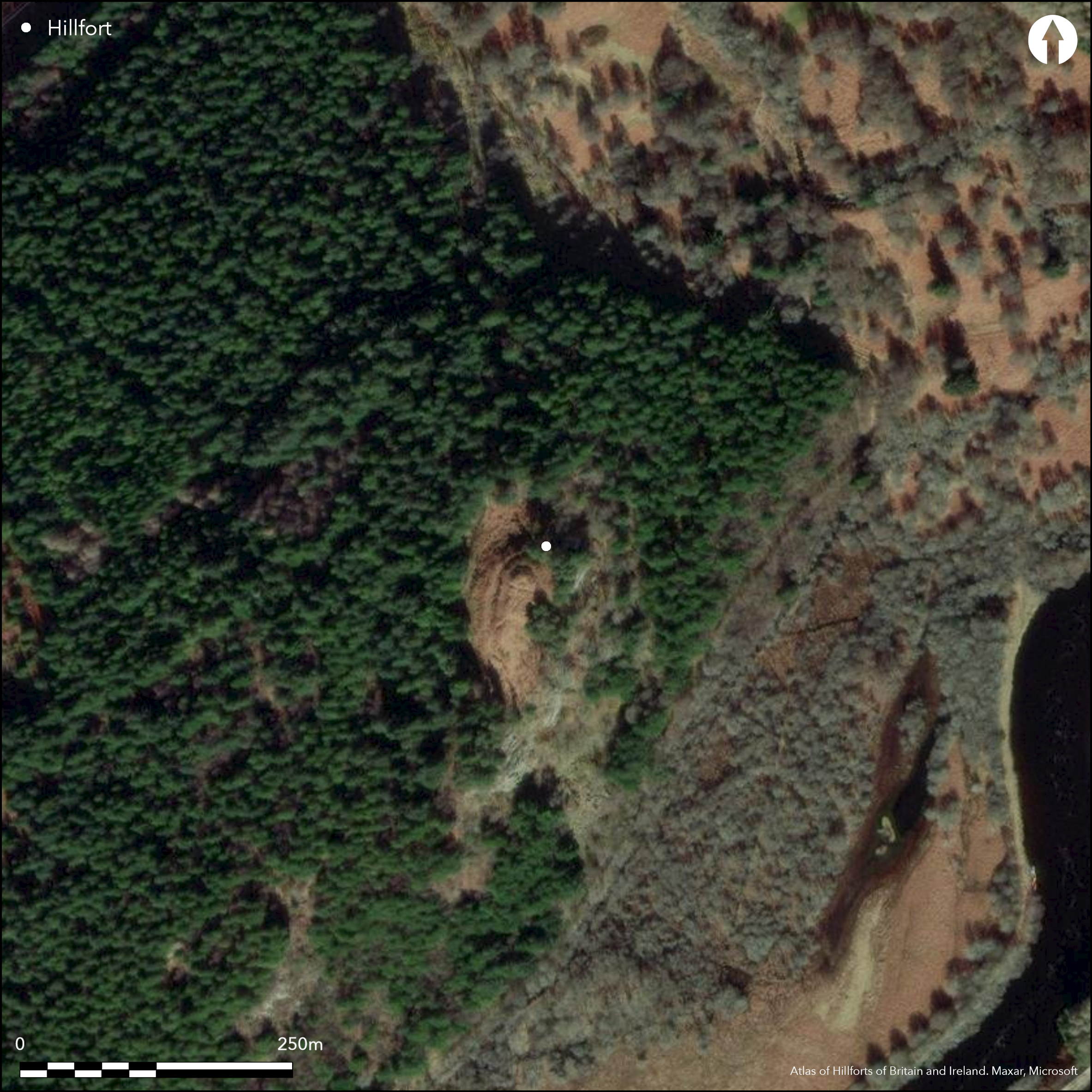
Occupying a rocky knoll above a precipitous crag that falls away abruptly into the valley of the River Oich on the E, this small fortification displays three roughly concentric lines of defence. The inner encloses the very summit of the knoll and measures 19m from NNE to SSW by about 10m transversely (0.02ha) within a heavily-vitrified wall reduced to a mound of rubble in excess of 3.5m in thickness where it is best preserved on the N and W flanks. The entrance is not visible, though probably on the SW and the only feature that can be seen within the heavily overgrown interior is an old excavation trench transecting the northern end. The second line of defence is a wall that extends around the shoulder of the summit area to enclose a larger area measuring about 38m along the same axis by a maximum of 18m transversely (0.06ha). Though reduced to a scarp everywhere except the N, in 1974 the OS surveyors were still able to trace the line of the outer face discontinuously round the whole circuit, but the only vitrified stones visible appeared to have tumbled from the innermost wall above. The entrance is on the SW, where a gully drops down the slope to the rear of the third line, yet another wall, extending around the foot of the knoll on the NW and S. Again, the OS observed a run of the inner face and a few outer facing-stones on the NW; here this third wall is about 1.7m in thickness, possibly increasing to about 3m adjacent to the entrance on the S. The sequence of construction is uncertain, though on the grounds that the middle wall seemed to be more heavily reduced than the inner, and that none of the pieces of vitrified stone they found on the lower walls appeared to be in situ, the OS were of the opinion that the inner enclosure on the summit had been inserted into an earlier fort.
Citizen Science: ✗
Reliability of Data: Confirmed
Reliability of Interpretation: Confirmed
X: -526470 Y: 7785463 (EPSG: 3857)
Longitude: -4.72936125873665 Latitude: 57.12379324489476 (EPSG:4326)
Country: Scotland
Current County or Unitary Authority: Highland
Historic County: Inverness-shire
Current Parish/Community/Council/Townland: Boleskine And Abertarf
None
| Extant | ✓ |
| Cropmark | ✗ |
| Likely Destroyed | ✗ |
Clearing in plantation
| Woodland | ✗ |
| Commercial Forestry Plantation | ✓ |
| Parkland | ✗ |
| Pasture (Grazing) | ✗ |
| Arable | ✗ |
| Scrub/Bracken | ✓ |
| Bare Outcrop | ✗ |
| Heather/Moorland | ✗ |
| Heath | ✗ |
| Built-up | ✗ |
| Coastal Grassland | ✗ |
| Other | ✗ |
None
| Contour Fort | ✓ |
| Partial Contour Fort | ✗ |
| Promontory Fort | ✗ |
| Hillslope Fort | ✗ |
| Level Terrain Fort | ✗ |
| Marsh Fort | ✗ |
| Multiple Enclosure Fort | ✗ |
| Hilltop | ✗ |
| Coastal Promontory | ✗ |
| Inland Promontory | ✗ |
| Valley Bottom | ✗ |
| Knoll/Hillock/Outcrop | ✓ |
| Ridge | ✗ |
| Cliff/Plateau-edge/Scarp | ✗ |
| Hillslope | ✗ |
| Lowland | ✗ |
| Spur | ✗ |
Dominant Topographic Feature: None
| North | ✗ |
| Northeast | ✗ |
| East | ✗ |
| Southeast | ✗ |
| South | ✗ |
| Southwest | ✗ |
| West | ✗ |
| Northwest | ✗ |
| Level | ✓ |
Altitude: 90.0m
N/A
In the absence of excavation, there are neither stratified artefacts nor radiocarbon dates to provide a chronology for the defences.
Reliability: D - None
| Pre 1200BC | ✗ |
| 1200BC - 800BC | ✗ |
| 800BC - 400BC | ✗ |
| 400BC - AD50 | ✗ |
| AD50 - AD400 | ✗ |
| AD400 - AD 800 | ✗ |
| Post AD800 | ✗ |
| Unknown | ✓ |
| Pre Hillfort: | None |
| Post Hillfort: | Possibly a dun inserted into the interior |
None
| 1st Identified Written Reference (1769): | Noted by Thomas Pennant (1772, 184) |
| 1st Identified Map Depiction (1871): | Annotated Vitrified Fort on the 1st edition OS 25-inch map (Inverness-shire 1873, sheet 83.1) |
| Other (1915): | Description (Ross 1915, 23-7) |
| Earthwork Survey (1921): | Description and plan (Wallace 1921, 106-7) |
| Other (1957): | Description for RCAHMS Survey of Marginal Lands (Feachem 1963, 181) |
| Other (1969): | Scheduled |
| Other (1970): | Visited by the OS |
| Other (1974): | Visited by the OS |
| Other (1979): | Revised at 1:10,000 by the OS |
| Earthwork Survey (2010): | Plan and description under dense bracken by Headland Archaeology (2011, 5-6 and fig 16) |
Occupied by the dun on the summit
None
| None | ✓ |
| Spring | ✗ |
| Stream | ✗ |
| Pool | ✗ |
| Flush | ✗ |
| Well | ✗ |
| Other | ✗ |
None
| No Known Features | ✓ |
| Round Stone Structures | ✗ |
| Rectangular Stone Structures | ✗ |
| Curvilinear Platforms | ✗ |
| Other Roundhouse Evidence | ✗ |
| Pits | ✗ |
| Quarry Hollows | ✗ |
| Other | ✗ |
None
| No Known Excavation | ✓ |
| Pits | ✗ |
| Postholes | ✗ |
| Roundhouses | ✗ |
| Rectangular Structures | ✗ |
| Roads/Tracks | ✗ |
| Quarry Hollows | ✗ |
| Other | ✗ |
| Nothing Found | ✗ |
None
| No Known Geophysics | ✓ |
| Pits | ✗ |
| Roundhouses | ✗ |
| Rectangular Structures | ✗ |
| Roads/Tracks | ✗ |
| Quarry Hollows | ✗ |
| Other | ✗ |
| Nothing Found | ✗ |
None
| No Known Finds | ✓ |
| Pottery | ✗ |
| Metal | ✗ |
| Metalworking | ✗ |
| Human Bones | ✗ |
| Animal Bones | ✗ |
| Lithics | ✗ |
| Environmental | ✗ |
| Other | ✗ |
NO APPARENT FEATURES
| APs Not Checked | ✗ |
| None | ✓ |
| Roundhouses | ✗ |
| Rectangular Structures | ✗ |
| Pits | ✗ |
| Postholes | ✗ |
| Roads/Tracks | ✗ |
| Other | ✗ |
See main summary
| 2: | None |
| 2: | Excludes innermost enclosure |
Guard Chambers: ✗
Chevaux de Frise: ✗
| 1. Simple Gap (South west): | Through middle wall (inner fort defence) |
| 1. Simple Gap (South): | Outermost wall |
Vitrified dun on the summit with two walls belonging to the hypothetically earlier fort
| Area 1: | 0.02ha. |
| Area 2: | 0.06ha. |
| Total: | 0.06ha. |
Total Footprint Area: 0.3ha.
None
| ✗ | None |
| ✓ | None |
| NE Quadrant: | 2 |
| SE Quadrant: | 2 |
| SW Quadrant: | 3 |
| NW Quadrant: | 3 |
| Total: | 3 |
| Partial Univallate | ✗ |
| Univallate | ✗ |
| Partial Bivallate | ✓ |
| Bivallate | ✗ |
| Partial Multivallate | ✓ |
| Multivallate | ✗ |
| Unknown | ✗ |
| Partial Univallate | ✗ |
| Univallate | ✗ |
| Partial Bivallate | ✗ |
| Bivallate | ✗ |
| Partial Multivallate | ✗ |
| Multivallate | ✗ |
In situ vitrifaction has only been observed in the dun wall, htough small bits have fallen down the slope and come to rest on the outer lines
| None | ✗ |
| Earthen Bank | ✗ |
| Stone Wall | ✓ |
| Rubble | ✗ |
| Wall-walk | ✗ |
| Evidence of Timber | ✗ |
| Vitrification | ✗ |
| Other Burning | ✗ |
| Palisade | ✗ |
| Counter Scarp Bank | ✗ |
| Berm | ✗ |
| Unfinished | ✗ |
| Other | ✗ |
None
| None | ✗ |
| Earthen Bank | ✗ |
| Stone Wall | ✗ |
| Murus Duplex | ✗ |
| Timber-framed | ✗ |
| Timber-laced | ✗ |
| Vitrification | ✗ |
| Other Burning | ✗ |
| Palisade | ✗ |
| Counter Scarp Bank | ✗ |
| Berm | ✗ |
| Unfinished | ✗ |
| No Known Excavation | ✓ |
| Other | ✗ |
| ✗ | None |
| ✗ | None |
Number of Ditches: None
| ✗ | None |
Cotton, M A (1954) 'British camps with timber-laced ramparts'. Archaeol J 111 (1954), 26-105 (p 78)
Feachem, R (1963) A guide to prehistoric Scotland. Batsford: London
Headland Archaeology Ltd (2011) A Topographic Survey of Five Pictish Forts in the Highlands. Report to the Forestry Commission
Pennant, T A (1772), A Tour in Scotland MDCCLXIX (2nd ed). R White: London
Ross, A (1915) 'Dun-Dhearduil and Tor-Duin hill forts'. Trans Inverness Sci Soc Fld Club 7, 23-7
Wallace, T (1921) 'Archaeological notes'. Trans Inverness Sci Soc Fld Club 8, 106-7
Atlas of Hillforts:
Wikidata:
This work is licensed under CC BY-SA 4.0![]()
![]()
![]() and should be cited as:
and should be cited as:
Lock, Gary and Ralston, Ian. 2024. Atlas of Hillforts of Britain and Ireland. Available at: https://hillforts.arch.ox.ac.uk
Document Version 1.1