Satellite Imagery
Satellite Imagery
HER: Highland HER MHG6994 (None)
NMR: NH 85 SE 7 (15203)
SM: 3087
NGR: NH 8880 5140
X: 288800 Y: 851400 (OSGB36)
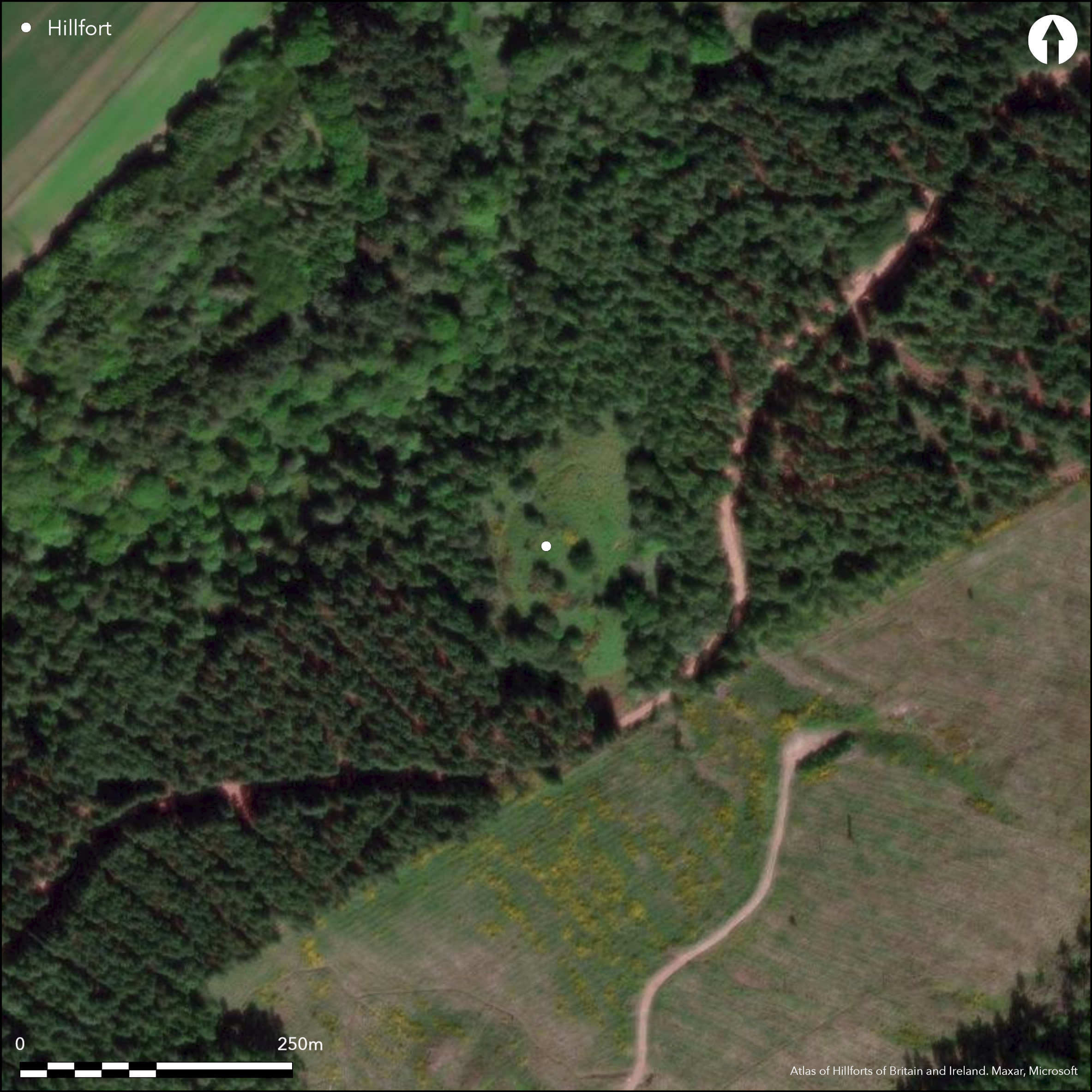
This fort occupies a knoll rising from the NW flank of the Hill of Urchany, from which the ground drops away sharply down to the Geddes Burn. The defences comprise two elements: a small oval enclosure occupying the N end of the summit; and an outer enclosure encircling its foot. The inner enclosure measures about 33m from N to S by 16m transversely (0.04ha) within a wall reduced to a mound of rubble about 6m in thickness, in which occasional pieces of vitrified stone can be found. A modern track approaches obliquely up the W flank of the knoll to gain access through a gap in the wall on the N, but it is not known whether this was also the position of the original entrance. While the inner enclosure occupies little more than half the summit area, the outer forms a much bigger circuit around its foot some 5m below, comprising a rampart about 3.5m in thickness by 1m in height with an internal quarry ditch cut back into the slope and about 3m in breadth by at least 1m in depth. This takes in a roughly oval area about 90m from N to S by 45m transversely (0.31ha), though the circuit is not continuous and in addition to the gap where the modern track crosses on the W, it is broken by two gaps on the S, another two on the E, and a fifth at the N tip. At this last, the terminals of the rampart overlap, but the ditch continues across the gap and it is uncertain whether this is an original entrance; in 1964 the OS suggested that a scarp outside this gap was the remains of a hornwork protecting the entrance. The southern of the gaps on the E partly coincides with a steep gully dropping down the slope to a water-hole at the foot of the knoll. The relationship between the inner and outer enclosures is unknown.
Citizen Science: ✗
Reliability of Data: Confirmed
Reliability of Interpretation: Confirmed
X: -429606 Y: 7871113 (EPSG: 3857)
Longitude: -3.85921297194759 Latitude: 57.539094778849766 (EPSG:4326)
Country: Scotland
Current County or Unitary Authority: Highland
Historic County: Nairn
Current Parish/Community/Council/Townland: Nairn
None
| Extant | ✓ |
| Cropmark | ✗ |
| Likely Destroyed | ✗ |
Clearing in commercial forestry plantation
| Woodland | ✓ |
| Commercial Forestry Plantation | ✗ |
| Parkland | ✗ |
| Pasture (Grazing) | ✗ |
| Arable | ✗ |
| Scrub/Bracken | ✓ |
| Bare Outcrop | ✗ |
| Heather/Moorland | ✓ |
| Heath | ✗ |
| Built-up | ✗ |
| Coastal Grassland | ✗ |
| Other | ✗ |
None
| Contour Fort | ✓ |
| Partial Contour Fort | ✗ |
| Promontory Fort | ✗ |
| Hillslope Fort | ✗ |
| Level Terrain Fort | ✗ |
| Marsh Fort | ✗ |
| Multiple Enclosure Fort | ✓ |
| Hilltop | ✗ |
| Coastal Promontory | ✗ |
| Inland Promontory | ✗ |
| Valley Bottom | ✗ |
| Knoll/Hillock/Outcrop | ✓ |
| Ridge | ✗ |
| Cliff/Plateau-edge/Scarp | ✗ |
| Hillslope | ✗ |
| Lowland | ✗ |
| Spur | ✗ |
Dominant Topographic Feature: None
| North | ✗ |
| Northeast | ✗ |
| East | ✗ |
| Southeast | ✗ |
| South | ✗ |
| Southwest | ✗ |
| West | ✗ |
| Northwest | ✗ |
| Level | ✓ |
Altitude: 85.0m
N/A
In the absence of excavation, there are neither stratified artefacts nor radiocarbon dates to provide a chronology for the defences.
Reliability: D - None
| Pre 1200BC | ✗ |
| 1200BC - 800BC | ✗ |
| 800BC - 400BC | ✗ |
| 400BC - AD50 | ✗ |
| AD50 - AD400 | ✗ |
| AD400 - AD 800 | ✗ |
| Post AD800 | ✗ |
| Unknown | ✓ |
| Pre Hillfort: | None |
| Post Hillfort: | None |
It was photographed by RCAHMS Aerial Survey Programme in 1994
| 1st Identified Written Reference (1777): | Noted by John Williams (1777, 36-8) |
| Earthwork Survey (1824): | Sketch-plan and description by George Anderson in a letter to Samuel Hibbert (1857, 196-7) |
| 1st Identified Map Depiction (1869): | Annotated Vitrified Fort on the 1st edition OS 25-inch map (Nairn 1871, sheet 4.12) |
| Earthwork Survey (1918): | Sketch-plan and description (Wallace 1918, 101-3) |
| Other (1943): | Description by Angus Graham and Gordon Childe for RCAHMS wartime Emergency Surveys |
| Earthwork Survey (1957): | Plan and description (RCAHMS DC 31566-7 & DP149878 & DP149902) |
| Other (1965): | Surveyed at 1:2500 by the OS |
| Other (1971): | Visited by the OS |
| Other (1971): | Scheduled |
| Other (1978): | Visited by RCAHMS |
| Other (1992): | Re-Scheduled |
Featureless
Waterhole outside the defences
| None | ✓ |
| Spring | ✗ |
| Stream | ✗ |
| Pool | ✗ |
| Flush | ✗ |
| Well | ✗ |
| Other | ✗ |
None
| No Known Features | ✓ |
| Round Stone Structures | ✗ |
| Rectangular Stone Structures | ✗ |
| Curvilinear Platforms | ✗ |
| Other Roundhouse Evidence | ✗ |
| Pits | ✗ |
| Quarry Hollows | ✗ |
| Other | ✗ |
None
| No Known Excavation | ✓ |
| Pits | ✗ |
| Postholes | ✗ |
| Roundhouses | ✗ |
| Rectangular Structures | ✗ |
| Roads/Tracks | ✗ |
| Quarry Hollows | ✗ |
| Other | ✗ |
| Nothing Found | ✗ |
None
| No Known Geophysics | ✓ |
| Pits | ✗ |
| Roundhouses | ✗ |
| Rectangular Structures | ✗ |
| Roads/Tracks | ✗ |
| Quarry Hollows | ✗ |
| Other | ✗ |
| Nothing Found | ✗ |
None
| No Known Finds | ✓ |
| Pottery | ✗ |
| Metal | ✗ |
| Metalworking | ✗ |
| Human Bones | ✗ |
| Animal Bones | ✗ |
| Lithics | ✗ |
| Environmental | ✗ |
| Other | ✗ |
NO APPARENT FEATURES
| APs Not Checked | ✗ |
| None | ✓ |
| Roundhouses | ✗ |
| Rectangular Structures | ✗ |
| Pits | ✗ |
| Postholes | ✗ |
| Roads/Tracks | ✗ |
| Other | ✗ |
See main summary
| 7: | None |
| 2: | None |
Guard Chambers: ✗
Chevaux de Frise: ✗
| 1. Over-lapping (North): | Gap in outer rampart with overlapping terminals, but uncertain if this is an entrance |
Vitrified wall on the summit and a ditch with an earthen rampart lower down the slope
| Area 1: | 0.04ha. |
| Area 2: | 0.31ha. |
| Total: | 0.31ha. |
Total Footprint Area: 0.49ha.
None
| ✗ | None |
| ✓ | None |
| NE Quadrant: | 2 |
| SE Quadrant: | 2 |
| SW Quadrant: | 2 |
| NW Quadrant: | 2 |
| Total: | 2 |
| Partial Univallate | ✗ |
| Univallate | ✗ |
| Partial Bivallate | ✗ |
| Bivallate | ✓ |
| Partial Multivallate | ✗ |
| Multivallate | ✗ |
| Unknown | ✗ |
| Partial Univallate | ✗ |
| Univallate | ✓ |
| Partial Bivallate | ✗ |
| Bivallate | ✗ |
| Partial Multivallate | ✗ |
| Multivallate | ✗ |
None
| None | ✗ |
| Earthen Bank | ✓ |
| Stone Wall | ✗ |
| Rubble | ✓ |
| Wall-walk | ✗ |
| Evidence of Timber | ✗ |
| Vitrification | ✓ |
| Other Burning | ✗ |
| Palisade | ✗ |
| Counter Scarp Bank | ✗ |
| Berm | ✗ |
| Unfinished | ✗ |
| Other | ✗ |
None
| None | ✗ |
| Earthen Bank | ✗ |
| Stone Wall | ✗ |
| Murus Duplex | ✗ |
| Timber-framed | ✗ |
| Timber-laced | ✗ |
| Vitrification | ✗ |
| Other Burning | ✗ |
| Palisade | ✗ |
| Counter Scarp Bank | ✗ |
| Berm | ✗ |
| Unfinished | ✗ |
| No Known Excavation | ✓ |
| Other | ✗ |
| ✗ | None |
| ✓ | Internal quarry ditch to the outer rampart |
Number of Ditches: 1
| ✗ | None |
Anderson, G (1857) 'On certain vitrified (and unvitrified) forts in the neighbourhood of Loch Ness and the Moray Firth. In a letter to Dr Hibbert'. Archaeologia Scotica 4 (1857), 195-201
Wallace, T (1918) 'Archaeological Notes'. Trans Inverness Sci Soc Fld Club 8 (1912-18), 87-136
Atlas of Hillforts:
Wikidata:
This work is licensed under CC BY-SA 4.0![]()
![]()
![]() and should be cited as:
and should be cited as:
Lock, Gary and Ralston, Ian. 2024. Atlas of Hillforts of Britain and Ireland. Available at: https://hillforts.arch.ox.ac.uk
Document Version 1.1