Satellite Imagery
Satellite Imagery
HER: Moray per Aberdeenshire Council NJ23NE0006 (None)
NMR: NJ 23 NE 1 (16307)
SM: None
NGR: NJ 2942 3930
X: 329420 Y: 839300 (OSGB36)
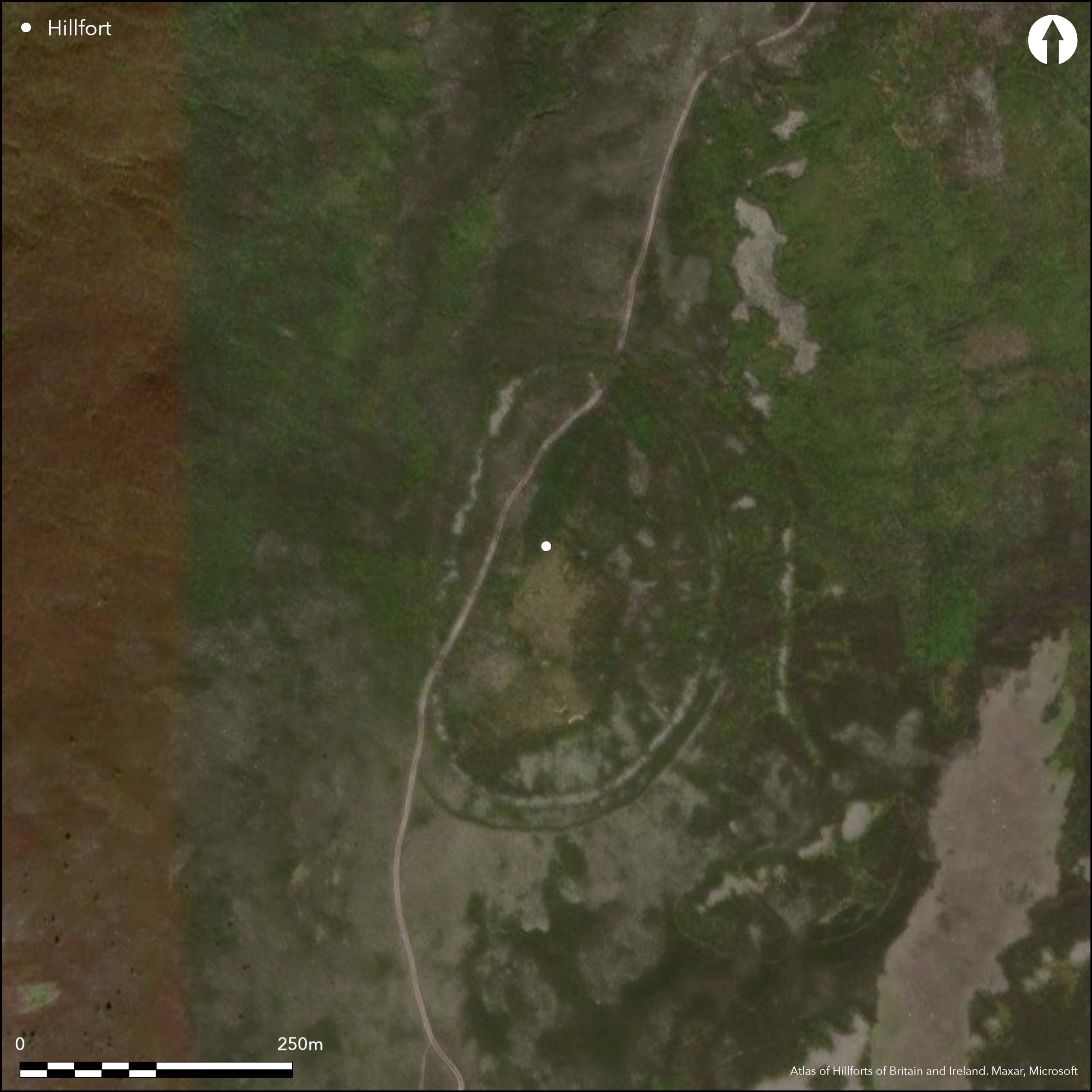
This fortification encloses the broad summit of Little Conval, the conical hill rising up due W of Dufftown. The character of the defences is not entirely clear, for while Richard Feachem identified this as the remains of an unfinished hillfort, with a rubble bank some 3m in maximum breadth representing the incomplete rampart round most of the circuit, but with only marker trenches about 1.2m in breadth and up to 0.3m in depth to complete the circuit on the NE and set out up to three outer lines elsewhere on the N and E, a more recent visit by RCAHMS investigators concluded that it was more likely that these features had supported massive palisades. The inner enclosure is oval on plan, measuring about 210m from N to S by 120m transversely (2ha) within the rubble bank, and is encircled by a second trench at a distance ranging from 5m and 14m outside it. Gaps in this outer trench on the ESE and SW probably mark the positions of entrances, though there are no corresponding breaks in the rubble bank, perhaps indicating that it is a later construction. In addition to these two lines, another two trenches cut across the spine of the hill on the N at intervals of 10m and 15m to protect the easiest line of approach up a relatively gentle slope, the inner swinging around the E flank where its line is apparently taken up by a stony bank that turns down the slope on the SE and peters out in an area of small field plots. The interior is featureless.
Citizen Science: ✗
Reliability of Data: Confirmed
Reliability of Interpretation: Confirmed
X: -353703 Y: 7850297 (EPSG: 3857)
Longitude: -3.177370754029459 Latitude: 57.438594297138465 (EPSG:4326)
Country: Scotland
Current County or Unitary Authority: Moray
Historic County: Banffshire
Current Parish/Community/Council/Townland: Mortlach
None
| Extant | ✓ |
| Cropmark | ✗ |
| Likely Destroyed | ✗ |
None
| Woodland | ✗ |
| Commercial Forestry Plantation | ✗ |
| Parkland | ✗ |
| Pasture (Grazing) | ✓ |
| Arable | ✗ |
| Scrub/Bracken | ✗ |
| Bare Outcrop | ✗ |
| Heather/Moorland | ✓ |
| Heath | ✗ |
| Built-up | ✗ |
| Coastal Grassland | ✗ |
| Other | ✗ |
None
| Contour Fort | ✓ |
| Partial Contour Fort | ✗ |
| Promontory Fort | ✗ |
| Hillslope Fort | ✗ |
| Level Terrain Fort | ✗ |
| Marsh Fort | ✗ |
| Multiple Enclosure Fort | ✗ |
| Hilltop | ✓ |
| Coastal Promontory | ✗ |
| Inland Promontory | ✗ |
| Valley Bottom | ✗ |
| Knoll/Hillock/Outcrop | ✗ |
| Ridge | ✗ |
| Cliff/Plateau-edge/Scarp | ✗ |
| Hillslope | ✗ |
| Lowland | ✗ |
| Spur | ✗ |
Dominant Topographic Feature: None
| North | ✗ |
| Northeast | ✗ |
| East | ✗ |
| Southeast | ✗ |
| South | ✗ |
| Southwest | ✗ |
| West | ✗ |
| Northwest | ✗ |
| Level | ✓ |
Altitude: 553.0m
N/A
In the absence of excavation, there are neither stratified artefacts nor radiocarbon dates to provide a chronology for the defences.
Reliability: D - None
| Pre 1200BC | ✗ |
| 1200BC - 800BC | ✗ |
| 800BC - 400BC | ✗ |
| 400BC - AD50 | ✗ |
| AD50 - AD400 | ✗ |
| AD400 - AD 800 | ✗ |
| Post AD800 | ✗ |
| Unknown | ✓ |
| Pre Hillfort: | None |
| Post Hillfort: | None |
Aberdeenshire Council hold a series of aerial views, copies of which can be found in the RCAHMS collection
| 1st Identified Map Depiction (1822): | Shown as enclosure on James Robertson's Topographical and Military Map of the Counties of Aberdeen, Banff and Kincardine (1822) |
| Other (1869): | Annotated Camp on the 1st edition OS 25-inch map (Banffshire 1872, sheet 24.12) |
| Other (1954): | Visited by Richard Feachem for RCAHMS Survey of Marginal Lands |
| Earthwork Survey (1956): | Plan and description for RCAHMS Survey of Marginal Lands (RCAHMS BND 1/1-2 & DP044251-2; Feachem 1963, 110-11; 1971, 28) |
| Other (1967): | Visited by the OS |
| Other (1990): | Visited by RCAHMS |
Featureless
None
| None | ✓ |
| Spring | ✗ |
| Stream | ✗ |
| Pool | ✗ |
| Flush | ✗ |
| Well | ✗ |
| Other | ✗ |
None
| No Known Features | ✓ |
| Round Stone Structures | ✗ |
| Rectangular Stone Structures | ✗ |
| Curvilinear Platforms | ✗ |
| Other Roundhouse Evidence | ✗ |
| Pits | ✗ |
| Quarry Hollows | ✗ |
| Other | ✗ |
None
| No Known Excavation | ✓ |
| Pits | ✗ |
| Postholes | ✗ |
| Roundhouses | ✗ |
| Rectangular Structures | ✗ |
| Roads/Tracks | ✗ |
| Quarry Hollows | ✗ |
| Other | ✗ |
| Nothing Found | ✗ |
None
| No Known Geophysics | ✓ |
| Pits | ✗ |
| Roundhouses | ✗ |
| Rectangular Structures | ✗ |
| Roads/Tracks | ✗ |
| Quarry Hollows | ✗ |
| Other | ✗ |
| Nothing Found | ✗ |
None
| No Known Finds | ✓ |
| Pottery | ✗ |
| Metal | ✗ |
| Metalworking | ✗ |
| Human Bones | ✗ |
| Animal Bones | ✗ |
| Lithics | ✗ |
| Environmental | ✗ |
| Other | ✗ |
NO APPARENT FEATURES
| APs Not Checked | ✗ |
| None | ✓ |
| Roundhouses | ✗ |
| Rectangular Structures | ✗ |
| Pits | ✗ |
| Postholes | ✗ |
| Roads/Tracks | ✗ |
| Other | ✗ |
See main summary
| 2: | None |
| 2: | None |
Guard Chambers: ✗
Chevaux de Frise: ✗
| 1. Simple Gap (East): | Through second palisade |
| 2. Simple Gap (South west): | Through second palisade |
Up to four palisade trenches, the inner two encircling the hilltop, and traces of a rubble bank which is possibly an unfinished rampart
| Area 1: | 2.0ha. |
| Total: | 2.0ha. |
Total Footprint Area: Noneha.
None
| ✓ | The rubble bank may overlie the innermost palisade trench |
| ✓ | For these purposes the palisade trenches are omitted |
| NE Quadrant: | 1 |
| SE Quadrant: | 1 |
| SW Quadrant: | 1 |
| NW Quadrant: | 2 |
| Total: | 2 |
| Partial Univallate | ✓ |
| Univallate | ✗ |
| Partial Bivallate | ✓ |
| Bivallate | ✗ |
| Partial Multivallate | ✗ |
| Multivallate | ✗ |
| Unknown | ✗ |
| Partial Univallate | ✗ |
| Univallate | ✗ |
| Partial Bivallate | ✗ |
| Bivallate | ✗ |
| Partial Multivallate | ✗ |
| Multivallate | ✗ |
Interpreted by RCAHMS investigators as marker trenches for an unfinished fort, but more likely they are palisade trenches
| None | ✗ |
| Earthen Bank | ✗ |
| Stone Wall | ✗ |
| Rubble | ✓ |
| Wall-walk | ✗ |
| Evidence of Timber | ✗ |
| Vitrification | ✗ |
| Other Burning | ✗ |
| Palisade | ✓ |
| Counter Scarp Bank | ✗ |
| Berm | ✗ |
| Unfinished | ✓ |
| Other | ✗ |
None
| None | ✗ |
| Earthen Bank | ✗ |
| Stone Wall | ✗ |
| Murus Duplex | ✗ |
| Timber-framed | ✗ |
| Timber-laced | ✗ |
| Vitrification | ✗ |
| Other Burning | ✗ |
| Palisade | ✗ |
| Counter Scarp Bank | ✗ |
| Berm | ✗ |
| Unfinished | ✗ |
| No Known Excavation | ✓ |
| Other | ✗ |
| ✗ | None |
| ✗ | None |
Number of Ditches: None
| ✗ | None |
Feachem, R (1963) A guide to prehistoric Scotland. Batsford: London
Feachem, R W (1971) 'Unfinished hill-forts', in Hill, D and Jesson, M (eds) The Iron Age and its hill-forts: papers presented to Sir Mortimer Wheeler on the occasion of his eightieth year. Southampton
Atlas of Hillforts:
Wikidata:
This work is licensed under CC BY-SA 4.0![]()
![]()
![]() and should be cited as:
and should be cited as:
Lock, Gary and Ralston, Ian. 2024. Atlas of Hillforts of Britain and Ireland. Available at: https://hillforts.arch.ox.ac.uk
Document Version 1.1