LiDAR 1m DTM Hillshade
Satellite Imagery
LiDAR 1m DTM Hillshade
Satellite Imagery
Scroll left/right to view further images.
HER: Aberdeenshire Historic Environment Record NJ62NW0001 (None)
NMR: NJ 62 NW 1 (18128)
SM: 95
NGR: NJ 6121 2816
X: 361215 Y: 828167 (OSGB36)
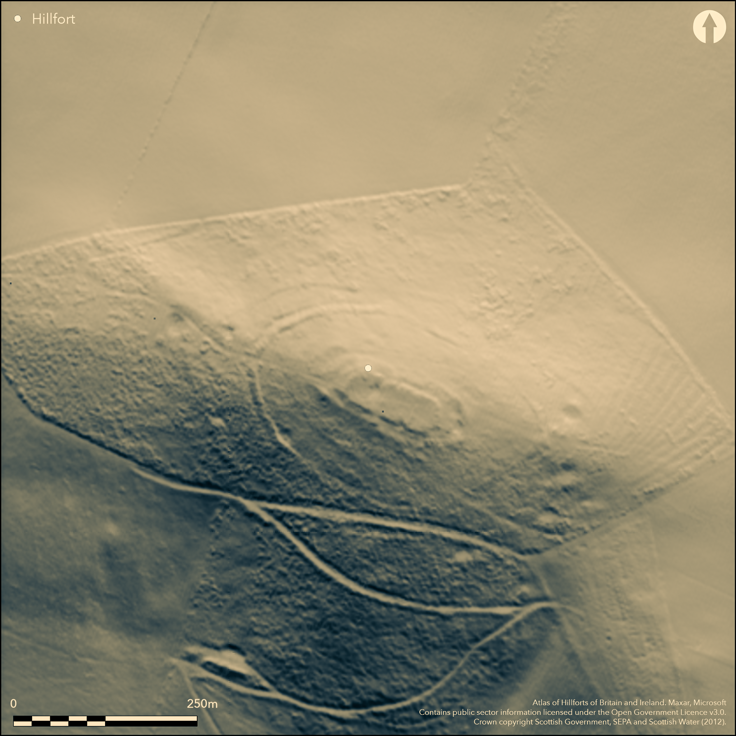
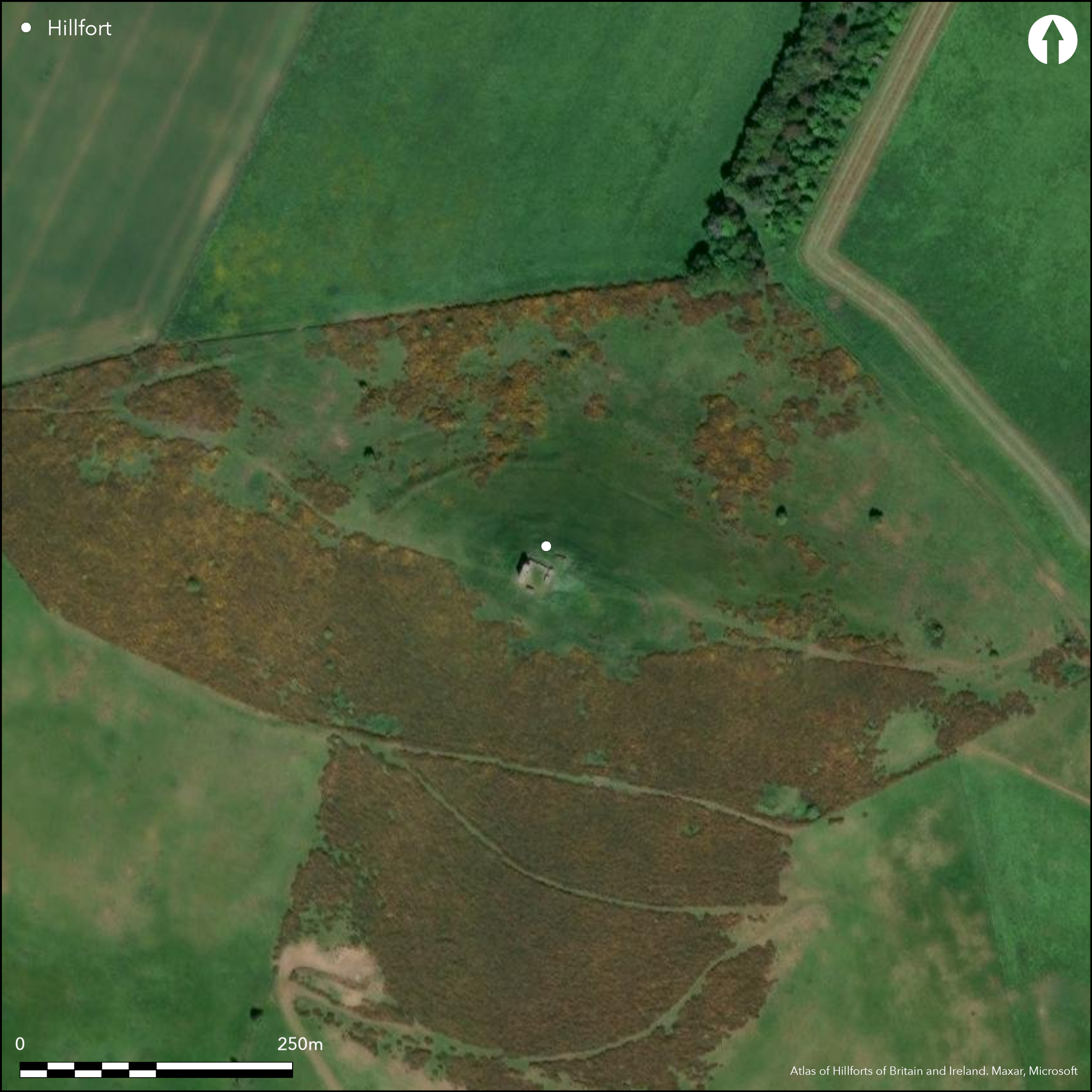
The keep of the castle that occupies the interior of the fort on the summit of Hill of Dunnideer is a well-known landmark visible throughout the Garioch. The defences of the fort comprise two main elements: an inner core representing up to four walls or ramparts and several phases of construction centred on a vitrified wall enclosing the very summit of the hill; and two outer ramparts forming a much bigger enclosure extending down the flanks of the hill. The vitrified wall has been heavily robbed, partly to build the keep overlying the WNW end, which was probably also accompanied by some form of enclosure extending ESE, though this has also been heavily robbed and is represented by little more than a robber trench and a band of rubble cutting across the interior of the fort some 30m to the ESE. The extent of this fort is marked out by large exposed masses of vitrifaction, suggesting an enclosure measuring about 65m from ESE to WNW by 23m transversely (0.16ha). This lies within a rather larger oval enclosure measuring about 100m in length by 42m in breadth (0.32ha) within a rampart reduced to a scarp, which is possibly an earlier line of defence with an entrance where the access track climbs the slope from the W. At least two heavily degraded ramparts reduced to scarps lie outside this line at this end, the inner of which can also be traced along the N flank of the hill to peter out on the E, where it is overlain by a row of three circular house platforms; these could be outworks to the larger enclosure on the summit, or indeed the remains of yet earlier defences. The outer enclosures display a markedly different character to the core of inner defences. Both comprise low ramparts constructed from material grubbed up from an internal quarry, though in places only the terrace of the rampart is visible. The inner is pierced by entrances on both the ESE and WNW, the latter approached from a gap in the outer across a causeway across the external ditch that accompanies the rampart round this end. Richard Feachem considered both this circuit and the even slighter line below it the remains of marker trenches for unfinished works (Feachem 1963, 105), but they are consistent features that gradually expand in size towards the entrances at either end, suggesting that both are as their builders intended, and possibly largely constructed in timber. The inner encloses an area measuring about 210m from ESE to WNW by 120m transversely (2.25ha), while the outer, which has been ploughed down by the cultivation of rigs at the ESE end is even larger, probably originally enclosing 3.6ha. In addition to the three already noted, there are traces of up to seven house platforms within the inner of the outer enclosures, but there are also a scatter of much better formed larger platforms outside both ends, two of those on the W apparently cut back into the line of the outermost perimeter. An evaluation trench dug in 2008 recovered charcoal samples from within and beneath rubble thought to have collapsed from the vitrified wall; they have returned dates of 360-160 BC, while archaeomagnetic dates from the vitrifaction span the period 606- 275 BC (Cook 2010, 85-6).
Citizen Science: ✗
Reliability of Data: Confirmed
Reliability of Interpretation: Confirmed
X: -294553 Y: 7830433 (EPSG: 3857)
Longitude: -2.6460135570239047 Latitude: 57.34242859587289 (EPSG:4326)
Country: Scotland
Current County or Unitary Authority: Aberdeenshire
Historic County: Aberdeenshire
Current Parish/Community/Council/Townland: Insch
None
| Extant | ✓ |
| Cropmark | ✗ |
| Likely Destroyed | ✗ |
None
| Woodland | ✗ |
| Commercial Forestry Plantation | ✗ |
| Parkland | ✗ |
| Pasture (Grazing) | ✓ |
| Arable | ✗ |
| Scrub/Bracken | ✓ |
| Bare Outcrop | ✗ |
| Heather/Moorland | ✓ |
| Heath | ✗ |
| Built-up | ✗ |
| Coastal Grassland | ✗ |
| Other | ✗ |
None
| Contour Fort | ✓ |
| Partial Contour Fort | ✗ |
| Promontory Fort | ✗ |
| Hillslope Fort | ✗ |
| Level Terrain Fort | ✗ |
| Marsh Fort | ✗ |
| Multiple Enclosure Fort | ✓ |
| Hilltop | ✓ |
| Coastal Promontory | ✗ |
| Inland Promontory | ✗ |
| Valley Bottom | ✗ |
| Knoll/Hillock/Outcrop | ✗ |
| Ridge | ✗ |
| Cliff/Plateau-edge/Scarp | ✗ |
| Hillslope | ✗ |
| Lowland | ✗ |
| Spur | ✗ |
Dominant Topographic Feature: Prominent local landmark
| North | ✗ |
| Northeast | ✗ |
| East | ✗ |
| Southeast | ✗ |
| South | ✗ |
| Southwest | ✗ |
| West | ✗ |
| Northwest | ✗ |
| Level | ✓ |
Altitude: 268.0m
N/A
Two dates in the span 390-160 BC, beneath the collapsed wall and argued to be related to the firing of the vitrified wall (Cook 2010, 85-6). Six archaeomagnetic dates from vitrifaction fall in the span 606-275 BC (Cook 2010, 86)
Reliability: D - None
| Pre 1200BC | ✗ |
| 1200BC - 800BC | ✗ |
| 800BC - 400BC | ✗ |
| 400BC - AD50 | ✓ |
| AD50 - AD400 | ✗ |
| AD400 - AD 800 | ✗ |
| Post AD800 | ✗ |
| Unknown | ✗ |
| Pre Hillfort: | None |
| Post Hillfort: | None |
| C14: | Two radiocarbon dates from hazel rod samples beneath and within the collapse of the vitrified wall |
| Other: | Six archaeomagnetic dates from vitrifaction |
Evidently a very early Schedule.
| 1st Identified Written Reference (1776): | Noted by Charles Cordiner (1780, 32-3) |
| Earthwork Survey (1782): | Sketch-plans (Anderson 1782, 89-90, pls ix &x) |
| Other (1796): | Vitrifaction noted (Stat Acct, 17, 1796, 487) |
| Other (1867): | Annotated Vitrified Fort on the 1st edition OS 25-inch map (Aberdeenshire 1870, sheet 44.5) |
| Earthwork Survey (1957): | Plan and description for RCAHMS Survey of Marginal Lands (RCAHMS ABD 311/1-2; Feachem 1966, 69, fig 6) |
| Other (1969): | Surveyed at 1:2500 by the OS |
| Other (1977): | Visits by Aberdeen Archaeological Services and also subsequently in 1985, 1988 and 1990 |
| Other (1981): | Visited by the Hill-Fort Study Group |
| Earthwork Survey (1996): | Plan and description by RCAHMS (DC44323 & DP005480; DC44601; Halliday 2007, 99 fig 6.25) |
| Other (2003): | Re-Scheduled |
| Other (2006): | Assessment and evaluation following fire damage (Badger and Dunwell 2006) |
| Excavation (2008): | Evaluation (Cook et al 2008; 2010) |
| Other (2010): | Archaeomagnetic samples taken (Cook 2010) |
The interior of the vitrified fort is featureless apart from the castle and its works, but there are up to ten circular house platforms within the inner of the outer enclosures, and others outside this, two of which cut into the outermost line
Several pits have been dug at the W end, one outside the defences and another just inside the outermost, but there is no reason to suppose either is a cistern or well
| None | ✓ |
| Spring | ✗ |
| Stream | ✗ |
| Pool | ✗ |
| Flush | ✗ |
| Well | ✗ |
| Other | ✗ |
None
| No Known Features | ✗ |
| Round Stone Structures | ✗ |
| Rectangular Stone Structures | ✗ |
| Curvilinear Platforms | ✓ |
| Other Roundhouse Evidence | ✗ |
| Pits | ✗ |
| Quarry Hollows | ✓ |
| Other | ✗ |
None
| No Known Excavation | ✗ |
| Pits | ✗ |
| Postholes | ✗ |
| Roundhouses | ✗ |
| Rectangular Structures | ✗ |
| Roads/Tracks | ✗ |
| Quarry Hollows | ✗ |
| Other | ✗ |
| Nothing Found | ✓ |
None
| No Known Geophysics | ✓ |
| Pits | ✗ |
| Roundhouses | ✗ |
| Rectangular Structures | ✗ |
| Roads/Tracks | ✗ |
| Quarry Hollows | ✗ |
| Other | ✗ |
| Nothing Found | ✗ |
None
| No Known Finds | ✓ |
| Pottery | ✗ |
| Metal | ✗ |
| Metalworking | ✗ |
| Human Bones | ✗ |
| Animal Bones | ✗ |
| Lithics | ✗ |
| Environmental | ✗ |
| Other | ✗ |
None
| APs Not Checked | ✗ |
| None | ✗ |
| Roundhouses | ✓ |
| Rectangular Structures | ✗ |
| Pits | ✗ |
| Postholes | ✗ |
| Roads/Tracks | ✗ |
| Other | ✗ |
See main summary
| 2: | Heavy robbing has extensively disrupted the inner defences |
| 2: | Only entrances visible are in the outer defences |
Guard Chambers: ✗
Chevaux de Frise: ✗
| 1. Simple Gap (East): | Through the inner of the two outer ramparts |
| 2. Simple Gap (West): | Through the inner of the two outer ramparts |
| 2. Simple Gap (West): | Through the outer of the two outer ramparts |
At least four ramparts of various forms, the innermost vitrified, encircling the hill top and representing several separate periods of construction
| Area 1: | 0.16ha. |
| Area 2: | 0.32ha. |
| Area 3: | 2.25ha. |
| Area 4: | 3.6ha. |
| Total: | 3.6ha. |
Total Footprint Area: 3.7ha.
None
| ✓ | None |
| ✓ | None |
| NE Quadrant: | 5 |
| SE Quadrant: | 4 |
| SW Quadrant: | 5 |
| NW Quadrant: | 6 |
| Total: | 6 |
| Partial Univallate | ✗ |
| Univallate | ✗ |
| Partial Bivallate | ✗ |
| Bivallate | ✗ |
| Partial Multivallate | ✗ |
| Multivallate | ✓ |
| Unknown | ✗ |
| Partial Univallate | ✗ |
| Univallate | ✓ |
| Partial Bivallate | ✗ |
| Bivallate | ✓ |
| Partial Multivallate | ✗ |
| Multivallate | ✗ |
Claimed as unfinished by Feachem, but largely on the slightness of elements of the outer enclosures, and not sustainable
| None | ✗ |
| Earthen Bank | ✓ |
| Stone Wall | ✓ |
| Rubble | ✗ |
| Wall-walk | ✗ |
| Evidence of Timber | ✗ |
| Vitrification | ✓ |
| Other Burning | ✗ |
| Palisade | ✗ |
| Counter Scarp Bank | ✗ |
| Berm | ✗ |
| Unfinished | ✓ |
| Other | ✗ |
None
| None | ✗ |
| Earthen Bank | ✗ |
| Stone Wall | ✓ |
| Murus Duplex | ✗ |
| Timber-framed | ✗ |
| Timber-laced | ✗ |
| Vitrification | ✗ |
| Other Burning | ✓ |
| Palisade | ✗ |
| Counter Scarp Bank | ✗ |
| Berm | ✗ |
| Unfinished | ✗ |
| No Known Excavation | ✗ |
| Other | ✗ |
| ✗ | None |
| ✓ | None |
Number of Ditches: 2
| ✗ | None |
Cook, M 2010 'New light on oblong forts: excavations at Dunnideer, Aberdeenshire'. Proc Soc Antiq Scot 140 (2010), 79-91
Cook, Dunbar and Engl, M, L and R (2008) 'Hillforts of Strathdon: Phase 2 - Maiden Castle and Dunnideer, Aberdeenshire (Insch / Oyne parishes), evaluation'. Discovery Excav Scot, New Ser, 9 (2008), 23
Cordiner, C (1780) Antiquities and scenery of the north of Scotland, in a series of letters to Thomas Pennant, Esq. London
Cotton, M A (1954) 'British camps with timber-laced ramparts'. Archaeol J 111 (1954), 26-105
Feachem, R (1963) A guide to prehistoric Scotland. Batsford: London (p 105)
Feachem, R W (1966) 'The hill-forts of northern Britain'. In Rivet, A L F (ed) The iron age in northern Britain. Edinburgh University Press Edinburgh
Halliday, S P (2007) The later prehistoric landscape. In RCAHMS (2007) In the Shadow of Bennachie: A Field Archaeology of Donside, Aberdeenshire. RCAHMS & Society of Antiquaries of Scotland: Edinburgh
Atlas of Hillforts:
Wikidata:
This work is licensed under CC BY-SA 4.0![]()
![]()
![]() and should be cited as:
and should be cited as:
Lock, Gary and Ralston, Ian. 2024. Atlas of Hillforts of Britain and Ireland. Available at: https://hillforts.arch.ox.ac.uk
Document Version 1.1