Satellite Imagery
Satellite Imagery
HER: Aberdeenshire Historic Environment Record NJ62NW0016 (None)
NMR: NJ 62 NW 21 (18141)
SM: 11394
NGR: NJ 6018 2742
X: 360180 Y: 827420 (OSGB36)
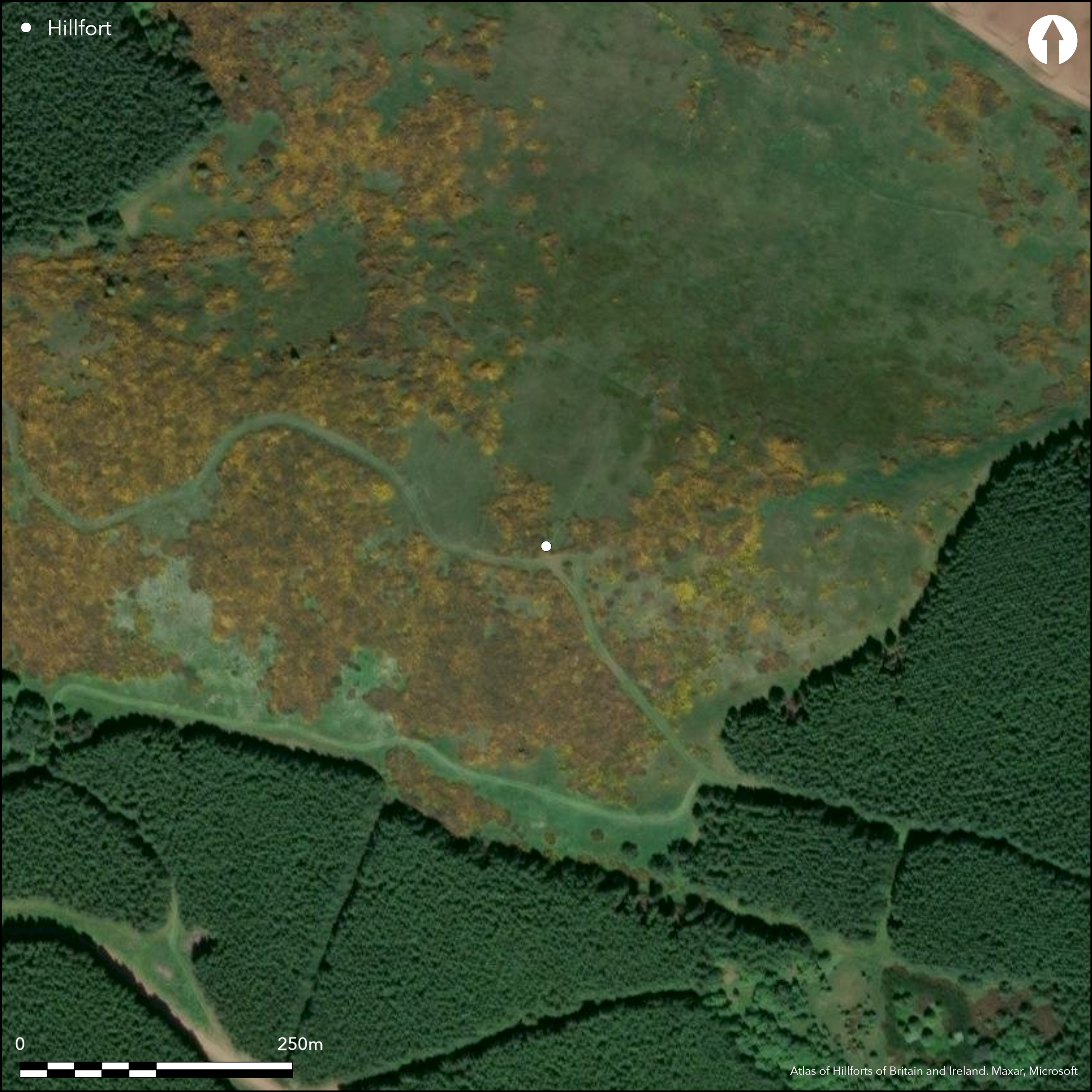
This enclosure occupies the summit Hill of Christ's Kirk and has variously been interpreted as the remains of at least three marker trenches for an unfinished fort, or a palisaded perimeter. On balance the latter is to be preferred, though RCAHMS investigators who first noted it could detect no trace of a trench in an exposed section of the outermost line on the SW, but in its hilltop position it should nevertheless by considered to be a fortification. Oval on plan, the two outer trenches, each of which is about 0.6m broad and has traces of an upcast bank on its outer lip, are set between 10m and 12m apart and enclose an oval area measuring 85m from E to W by 64m transversely (0.43ha), and there are possible traces of yet another trench placed concentrically about 8m beyond them round the W quarter. Eccentrically within the interior, which is otherwise featureless, an inner enclosure measuring about 43m in internal diameter (0.15ha) can also be seen; it probably represents a separate phase of construction, though whether earlier or later is unknown. The courses of the various perimeters are difficult to track in the long grass and whins, and the position of the entrance is unknown.
Citizen Science: ✗
Reliability of Data: Confirmed
Reliability of Interpretation: Confirmed
X: -296454 Y: 7829030 (EPSG: 3857)
Longitude: -2.6630872229781373 Latitude: 57.33562937712403 (EPSG:4326)
Country: Scotland
Current County or Unitary Authority: Aberdeenshire
Historic County: Aberdeenshire
Current Parish/Community/Council/Townland: Kennethmont
None
| Extant | ✓ |
| Cropmark | ✗ |
| Likely Destroyed | ✗ |
Gorse and coarse grasses in a clearing in aplantation
| Woodland | ✗ |
| Commercial Forestry Plantation | ✗ |
| Parkland | ✗ |
| Pasture (Grazing) | ✗ |
| Arable | ✗ |
| Scrub/Bracken | ✓ |
| Bare Outcrop | ✗ |
| Heather/Moorland | ✓ |
| Heath | ✗ |
| Built-up | ✗ |
| Coastal Grassland | ✗ |
| Other | ✗ |
None
| Contour Fort | ✓ |
| Partial Contour Fort | ✗ |
| Promontory Fort | ✗ |
| Hillslope Fort | ✗ |
| Level Terrain Fort | ✗ |
| Marsh Fort | ✗ |
| Multiple Enclosure Fort | ✗ |
| Hilltop | ✓ |
| Coastal Promontory | ✗ |
| Inland Promontory | ✗ |
| Valley Bottom | ✗ |
| Knoll/Hillock/Outcrop | ✗ |
| Ridge | ✗ |
| Cliff/Plateau-edge/Scarp | ✗ |
| Hillslope | ✗ |
| Lowland | ✗ |
| Spur | ✗ |
Dominant Topographic Feature: None
| North | ✗ |
| Northeast | ✗ |
| East | ✗ |
| Southeast | ✗ |
| South | ✗ |
| Southwest | ✗ |
| West | ✗ |
| Northwest | ✗ |
| Level | ✓ |
Altitude: 310.0m
N/A
In the absence of excavation, there are neither stratified artefacts nor radiocarbon dates to provide a chronology for the defences.
Reliability: D - None
| Pre 1200BC | ✗ |
| 1200BC - 800BC | ✗ |
| 800BC - 400BC | ✗ |
| 400BC - AD50 | ✗ |
| AD50 - AD400 | ✗ |
| AD400 - AD 800 | ✗ |
| Post AD800 | ✗ |
| Unknown | ✓ |
| Pre Hillfort: | None |
| Post Hillfort: | Overlain on the SE by rig and furrow |
Aberdeen Archaeological Services have recorded the site on oblique aerial photographs, copies of which are held by Aberdeenshire Council and RCAHMS.
| 1st Identified Written Reference (1956): | Identified by RCAHMS Survey of Marginal Land |
| Earthwork Survey (1956): | Plan and description (RCAHMS ABD 3/1-2 & DP 147305-6; NB DP 147305 is a rescaled ink version with the wrong scale bar) |
| 1st Identified Map Depiction (1969): | Surveyed at 1:2500 by the OS |
| Other (1996): | Description by RCAHMS (Halliday 2007, 103 with wrong measurements) |
| Other (2006): | Scheduled |
Featureless
None
| None | ✓ |
| Spring | ✗ |
| Stream | ✗ |
| Pool | ✗ |
| Flush | ✗ |
| Well | ✗ |
| Other | ✗ |
None
| No Known Features | ✓ |
| Round Stone Structures | ✗ |
| Rectangular Stone Structures | ✗ |
| Curvilinear Platforms | ✗ |
| Other Roundhouse Evidence | ✗ |
| Pits | ✗ |
| Quarry Hollows | ✗ |
| Other | ✗ |
None
| No Known Excavation | ✓ |
| Pits | ✗ |
| Postholes | ✗ |
| Roundhouses | ✗ |
| Rectangular Structures | ✗ |
| Roads/Tracks | ✗ |
| Quarry Hollows | ✗ |
| Other | ✗ |
| Nothing Found | ✗ |
None
| No Known Geophysics | ✓ |
| Pits | ✗ |
| Roundhouses | ✗ |
| Rectangular Structures | ✗ |
| Roads/Tracks | ✗ |
| Quarry Hollows | ✗ |
| Other | ✗ |
| Nothing Found | ✗ |
None
| No Known Finds | ✓ |
| Pottery | ✗ |
| Metal | ✗ |
| Metalworking | ✗ |
| Human Bones | ✗ |
| Animal Bones | ✗ |
| Lithics | ✗ |
| Environmental | ✗ |
| Other | ✗ |
NO APPARENT FEATURES
| APs Not Checked | ✗ |
| None | ✓ |
| Roundhouses | ✗ |
| Rectangular Structures | ✗ |
| Pits | ✗ |
| Postholes | ✗ |
| Roads/Tracks | ✗ |
| Other | ✗ |
None known
| 0: | The remains are ephemeral and disontinuous |
| 2: | Not known |
Guard Chambers: ✗
Chevaux de Frise: ✗
At least three lines of shallow trenches that are superficially comparable to palisade trenches in south-eastern Scotland
| Area 1: | 0.15ha. |
| Area 2: | 0.43ha. |
| Area 3: | 0.75ha. |
| Total: | 0.75ha. |
Total Footprint Area: 0.8ha.
None
| ✗ | None |
| ✓ | None |
| NE Quadrant: | 3 |
| SE Quadrant: | 3 |
| SW Quadrant: | 4 |
| NW Quadrant: | 4 |
| Total: | 4 |
| Partial Univallate | ✗ |
| Univallate | ✗ |
| Partial Bivallate | ✗ |
| Bivallate | ✗ |
| Partial Multivallate | ✗ |
| Multivallate | ✓ |
| Unknown | ✗ |
| Partial Univallate | ✗ |
| Univallate | ✗ |
| Partial Bivallate | ✗ |
| Bivallate | ✗ |
| Partial Multivallate | ✗ |
| Multivallate | ✗ |
Claimed to be marker trenches of an unfinished fort but more likely to be palisade trenches
| None | ✗ |
| Earthen Bank | ✗ |
| Stone Wall | ✗ |
| Rubble | ✗ |
| Wall-walk | ✗ |
| Evidence of Timber | ✗ |
| Vitrification | ✗ |
| Other Burning | ✗ |
| Palisade | ✓ |
| Counter Scarp Bank | ✗ |
| Berm | ✗ |
| Unfinished | ✓ |
| Other | ✗ |
None
| None | ✗ |
| Earthen Bank | ✗ |
| Stone Wall | ✗ |
| Murus Duplex | ✗ |
| Timber-framed | ✗ |
| Timber-laced | ✗ |
| Vitrification | ✗ |
| Other Burning | ✗ |
| Palisade | ✗ |
| Counter Scarp Bank | ✗ |
| Berm | ✗ |
| Unfinished | ✗ |
| No Known Excavation | ✓ |
| Other | ✗ |
| ✗ | None |
| ✗ | None |
Number of Ditches: None
| ✗ | None |
Halliday, S P (2007) The later prehistoric landscape. In RCAHMS (2007) In the Shadow of Bennachie: A Field Archaeology of Donside, Aberdeenshire. RCAHMS & Society of Antiquaries of Scotland: Edinburgh
Atlas of Hillforts:
Wikidata:
This work is licensed under CC BY-SA 4.0![]()
![]()
![]() and should be cited as:
and should be cited as:
Lock, Gary and Ralston, Ian. 2024. Atlas of Hillforts of Britain and Ireland. Available at: https://hillforts.arch.ox.ac.uk
Document Version 1.1