Satellite Imagery
Satellite Imagery
HER: Aberdeenshire Historic Environment Record NJ71NE0060 (None)
NMR: NJ 71 NE 3 (18586)
SM: 12523
NGR: NJ 7685 1900
X: 376850 Y: 819000 (OSGB36)
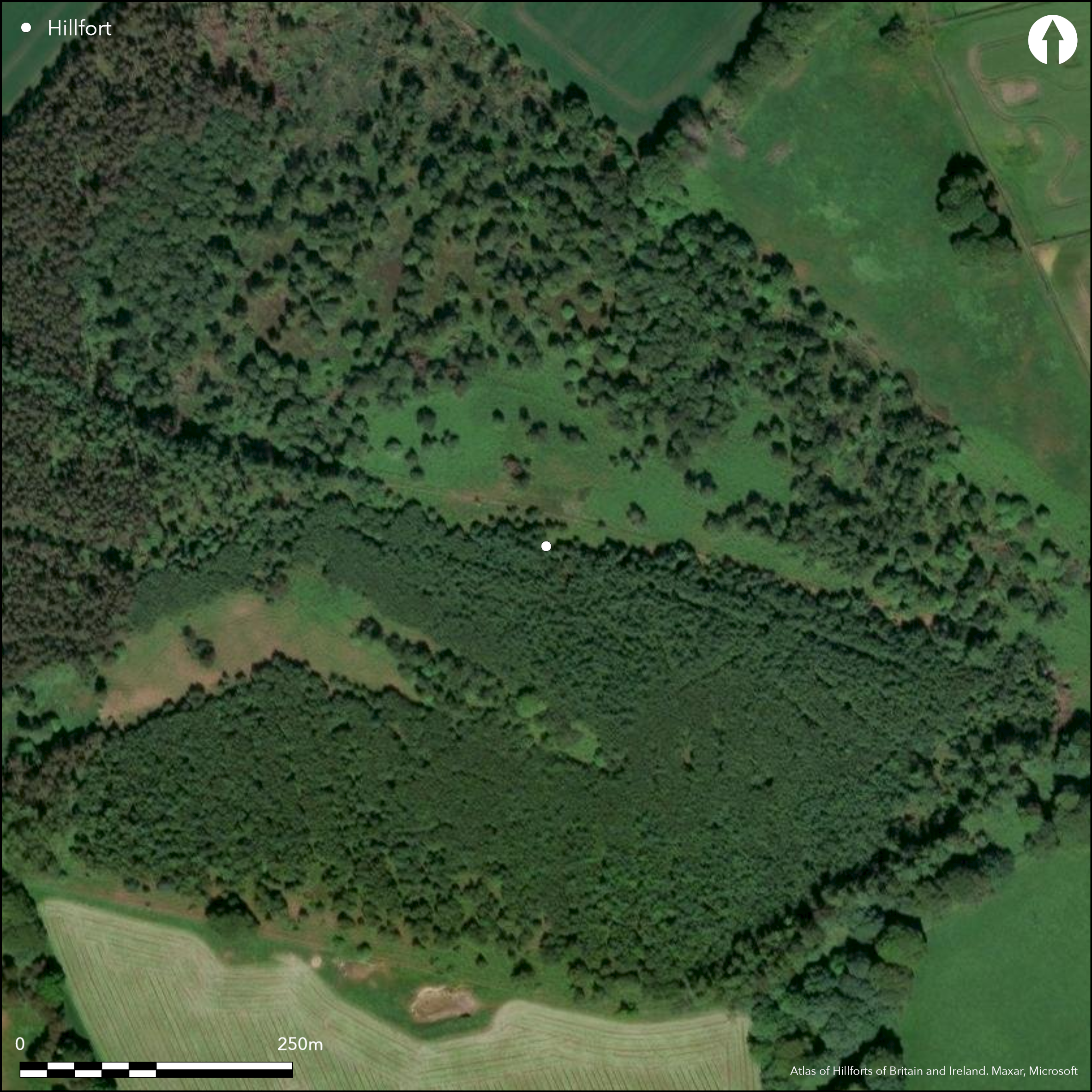
This fort occupies the rounded summit of Shaw Hill and extends a little way down its E spur where the surrounding slopes are slightly steeper. At the time it was surveyed by RCAHMS in 2002, the fort had only recently been cleared of trees and was strewn with stumps and brashings which obscured much of the interior. Nevertheless, the main defences comprise a rampart up to 5m in thickness and from 0.7m to 1.5m in height enclosing an elongated area measuring about 225m from ESE to WNW by 135m transversely (2.7ha). An outer rampart reduced to a scarp 0.5m high can be traced around the S and W, but it apparently converges on the line of the inner on the SSE and NNW, indicating that it may belong to an earlier circuit; in places an internal quarry scoop can be detected to its rear, while at one point on the WNW it is accompanied by a shallow external ditch. There is an entrance on the WNW, and two other gaps on the SSE and N respectively may also be original. A fourth gap near the W angle is probably modern, and the inner rampart adjacent to this has been heavily disturbed by the excavation of trenches and bunkers during WWII. Rig and furrow extends across much of the interior, the only other visible feature being a cup-marked stone. In 1983 pieces of vitrifaction were noted in the rampart at the W end (Watt 1983) and excavation trenches dug across the defences in 2006, demonstrated that the inner rampart, which measured 2.6m in thickness by 1m in height, had been extensively burnt. There was no evidence that the outer rampart had been burnt, but at some point following the destruction of the inner a relatively narrow wall about 1m thick was built between the two on the WNW (Cook et al 2006).
Citizen Science: ✗
Reliability of Data: Confirmed
Reliability of Interpretation: Confirmed
X: -265541 Y: 7813684 (EPSG: 3857)
Longitude: -2.385394651086968 Latitude: 57.26114873098052 (EPSG:4326)
Country: Scotland
Current County or Unitary Authority: Aberdeenshire
Historic County: Aberdeenshire
Current Parish/Community/Council/Townland: Kintore
None
| Extant | ✓ |
| Cropmark | ✗ |
| Likely Destroyed | ✗ |
Formerly under trees
| Woodland | ✓ |
| Commercial Forestry Plantation | ✗ |
| Parkland | ✗ |
| Pasture (Grazing) | ✗ |
| Arable | ✗ |
| Scrub/Bracken | ✓ |
| Bare Outcrop | ✗ |
| Heather/Moorland | ✗ |
| Heath | ✗ |
| Built-up | ✗ |
| Coastal Grassland | ✗ |
| Other | ✗ |
None
| Contour Fort | ✓ |
| Partial Contour Fort | ✗ |
| Promontory Fort | ✗ |
| Hillslope Fort | ✗ |
| Level Terrain Fort | ✗ |
| Marsh Fort | ✗ |
| Multiple Enclosure Fort | ✗ |
| Hilltop | ✓ |
| Coastal Promontory | ✗ |
| Inland Promontory | ✗ |
| Valley Bottom | ✗ |
| Knoll/Hillock/Outcrop | ✗ |
| Ridge | ✗ |
| Cliff/Plateau-edge/Scarp | ✗ |
| Hillslope | ✗ |
| Lowland | ✗ |
| Spur | ✗ |
Dominant Topographic Feature: None
| North | ✗ |
| Northeast | ✗ |
| East | ✓ |
| Southeast | ✗ |
| South | ✗ |
| Southwest | ✗ |
| West | ✗ |
| Northwest | ✗ |
| Level | ✗ |
Altitude: 174.0m
N/A
Dates of 540-360 BC from the base of the collapsed rampart, and 410-340 BC from a post burnt in situ. A fragment of a Roman Iron Age crucible was also recovered.
Reliability: D - None
| Pre 1200BC | ✗ |
| 1200BC - 800BC | ✗ |
| 800BC - 400BC | ✗ |
| 400BC - AD50 | ✓ |
| AD50 - AD400 | ✗ |
| AD400 - AD 800 | ✗ |
| Post AD800 | ✗ |
| Unknown | ✗ |
| Pre Hillfort: | None |
| Post Hillfort: | None |
| C14: | Two dates |
None
| 1st Identified Map Depiction (1867): | Named in Gothic type on the 1st edition OS 25-inch map (Aberdeenshire 1869, sheet 54.12) |
| Other (1954): | Description for RCAHMS Survey of Marginal Lands |
| Other (1964): | Surveyed at 1:2500 by the OS |
| Other (1983): | Vitrifaction noted (Watt 1983) |
| Earthwork Survey (2002): | Plan and description (RCAHMS DC44603; Halliday 2007, 97-100, fig 6.25) |
| Excavation (2006): | Directed by Murray Cook (Cook et al 2006) |
| Other (2009): | Scheduled |
Featureless apart from rig and furrow and a cupmarked stone
None
| None | ✓ |
| Spring | ✗ |
| Stream | ✗ |
| Pool | ✗ |
| Flush | ✗ |
| Well | ✗ |
| Other | ✗ |
None
| No Known Features | ✓ |
| Round Stone Structures | ✗ |
| Rectangular Stone Structures | ✗ |
| Curvilinear Platforms | ✗ |
| Other Roundhouse Evidence | ✗ |
| Pits | ✗ |
| Quarry Hollows | ✗ |
| Other | ✗ |
None
| No Known Excavation | ✗ |
| Pits | ✓ |
| Postholes | ✓ |
| Roundhouses | ✗ |
| Rectangular Structures | ✗ |
| Roads/Tracks | ✗ |
| Quarry Hollows | ✗ |
| Other | ✗ |
| Nothing Found | ✗ |
None
| No Known Geophysics | ✓ |
| Pits | ✗ |
| Roundhouses | ✗ |
| Rectangular Structures | ✗ |
| Roads/Tracks | ✗ |
| Quarry Hollows | ✗ |
| Other | ✗ |
| Nothing Found | ✗ |
Fragment of Roman Iron Age crucible
| No Known Finds | ✗ |
| Pottery | ✗ |
| Metal | ✗ |
| Metalworking | ✓ |
| Human Bones | ✗ |
| Animal Bones | ✗ |
| Lithics | ✗ |
| Environmental | ✗ |
| Other | ✗ |
NO APPARENT FEATURES
| APs Not Checked | ✓ |
| None | ✗ |
| Roundhouses | ✗ |
| Rectangular Structures | ✗ |
| Pits | ✗ |
| Postholes | ✗ |
| Roads/Tracks | ✗ |
| Other | ✗ |
See main summary
| 4: | None |
| 2: | None |
Guard Chambers: ✗
Chevaux de Frise: ✗
| 1. Simple Gap (North): | None |
| 2. Simple Gap (South): | None |
| 3. Simple Gap (West): | None |
Single rampart, but with an outer at one end possibly belonging to an earlier circuit
| Area 1: | 2.7ha. |
| Total: | 2.7ha. |
Total Footprint Area: Noneha.
None
| ✗ | None |
| ✓ | None |
| NE Quadrant: | 1 |
| SE Quadrant: | 1 |
| SW Quadrant: | 1 |
| NW Quadrant: | 2 |
| Total: | 2 |
| Partial Univallate | ✓ |
| Univallate | ✗ |
| Partial Bivallate | ✓ |
| Bivallate | ✗ |
| Partial Multivallate | ✗ |
| Multivallate | ✗ |
| Unknown | ✗ |
| Partial Univallate | ✗ |
| Univallate | ✗ |
| Partial Bivallate | ✗ |
| Bivallate | ✗ |
| Partial Multivallate | ✗ |
| Multivallate | ✗ |
None
| None | ✗ |
| Earthen Bank | ✗ |
| Stone Wall | ✓ |
| Rubble | ✗ |
| Wall-walk | ✗ |
| Evidence of Timber | ✗ |
| Vitrification | ✓ |
| Other Burning | ✗ |
| Palisade | ✗ |
| Counter Scarp Bank | ✗ |
| Berm | ✗ |
| Unfinished | ✗ |
| Other | ✗ |
None
| None | ✗ |
| Earthen Bank | ✗ |
| Stone Wall | ✓ |
| Murus Duplex | ✗ |
| Timber-framed | ✗ |
| Timber-laced | ✓ |
| Vitrification | ✓ |
| Other Burning | ✗ |
| Palisade | ✗ |
| Counter Scarp Bank | ✗ |
| Berm | ✗ |
| Unfinished | ✗ |
| No Known Excavation | ✗ |
| Other | ✗ |
| ✗ | None |
| ✓ | None |
Number of Ditches: 1
| ✗ | None |
Cook, Engl and Dunbar, M, R and L (2006) 'Kintore Landscape Project, Aberdeenshire (Kintore parish), evaluation'. Disc Exc Scot, New Ser, 7 (2006), 19
Halliday, S P (2007) The later prehistoric landscape. In RCAHMS (2007) In the Shadow of Bennachie: A Field Archaeology of Donside, Aberdeenshire. RCAHMS & Society of Antiquaries of Scotland: Edinburgh
Watt, W (1983) 'Bruce's Camp (Kintore p): vitrification'. Disc Exc Scot (1983), 11
Atlas of Hillforts:
Wikidata:
This work is licensed under CC BY-SA 4.0![]()
![]()
![]() and should be cited as:
and should be cited as:
Lock, Gary and Ralston, Ian. 2024. Atlas of Hillforts of Britain and Ireland. Available at: https://hillforts.arch.ox.ac.uk
Document Version 1.1