Satellite Imagery
Satellite Imagery
HER: Aberdeenshire Historic Environment Record NJ82NW0003 (None)
NMR: NJ 82 NW 4 (19668)
SM: 3997
NGR: NJ 8025 2570
X: 380250 Y: 825700 (OSGB36)
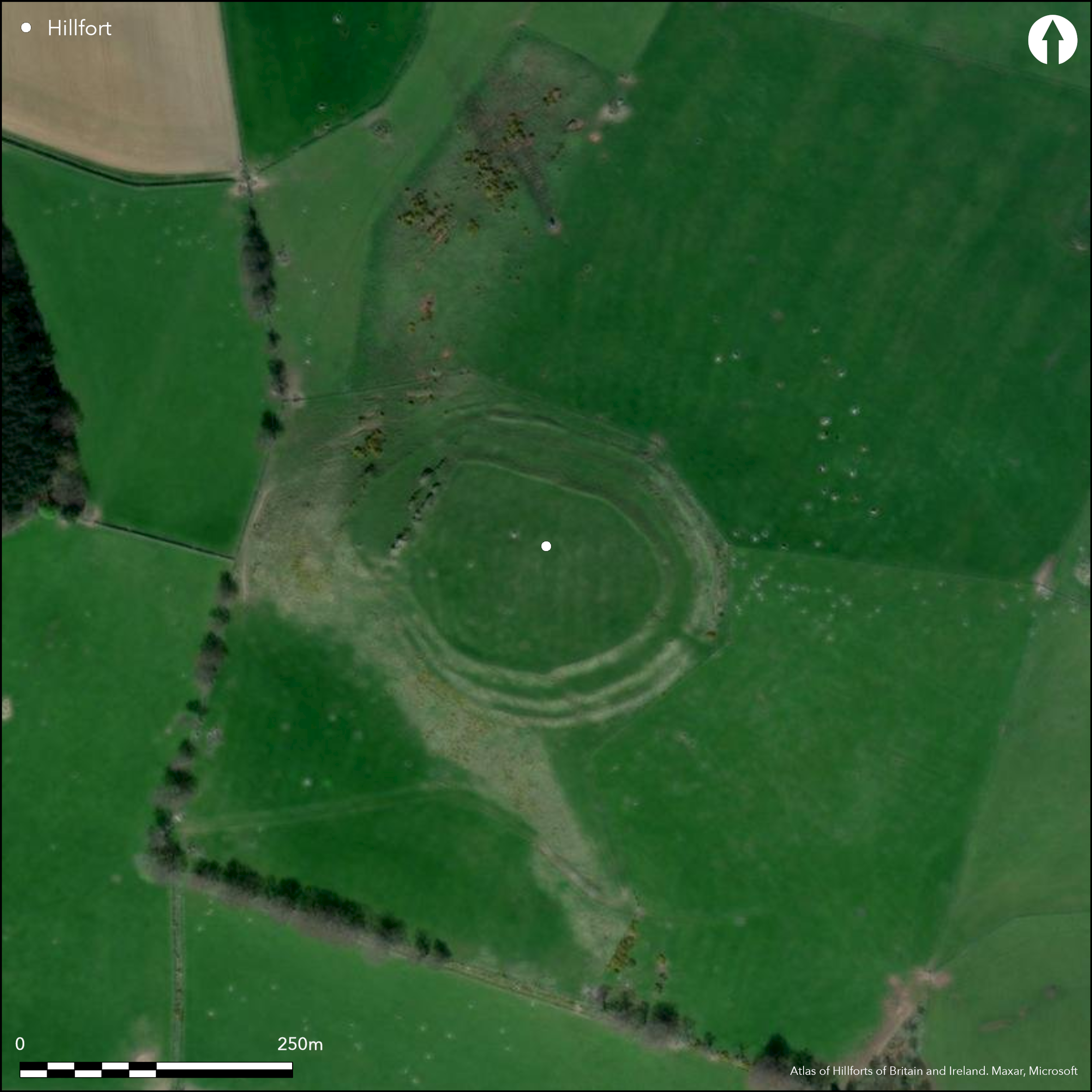
The multivallate fort situated on the summit of Barra Hill exhibits three phases of construction, though the last phase appears to be no more than the creation of an agricultural enclosure to enclose the rigs visible in the interior with a stone-faced dyke extending round the rim of the inner rampart and blocking the entrance on the W. This sequence on the W shows that the inner rampart had already been heavily robbed in this sector, to the extent that only the dyke can be traced northwards along the crest of the outcrops on the W flank of the summit. Nevertheless, the innermost rampart and its accompanying external ditch represent the second phase of construction, pierced by opposed entrances on the E and W, and with what may be a more recent break on the N, but blocking the entrance through the outer ramparts on the S. Roughly oval, this inner enclosure measures 122m from E to W by a maximum of 95m transversely (0.92ha) within its rampart. The two outer ramparts and their ditches enclose an area measuring about 155m from E to W by 125m transversely (1.54ha), but while they present steep well-formed profiles on the SE and NE quarters, elsewhere they are largely reduced to two concentric terraces, and there is no trace of the inner at all below the outcrops on the W; lengths of a counterscarp rampart are visible on the lip of the outer ditch on the S and N. There were probably entrance at all four cardinal points though the remains of those on the N and W have been heavily distorted by later activity. Of the other two, the eastern is the better preserved, with traces of the ramparts returning around the terminals of the ditches to form a stone-faced entrance way over 15m long, and there are hints of a similar arrangement on the S also. Excavations across the defences by Murray Cook recovered charcoal samples from the primary fills of two ditches, the inner either accompanying the innermost rampart or a quarry to the rear of the middle rampart, and the outer between the middle and outermost ramparts; the former dates to 560-360 BC and the latter AD 380-580. At face value the outer defences of the multivallate fort visible in the surviving earthworks were had probably been constructed at or by the earlier date, but that there was also a much later phase of refurbishment in the early medieval period (Cook 2011; 2012).
Citizen Science: ✗
Reliability of Data: Confirmed
Reliability of Interpretation: Confirmed
X: -259326 Y: 7826115 (EPSG: 3857)
Longitude: -2.3295692690652325 Latitude: 57.32149392313658 (EPSG:4326)
Country: Scotland
Current County or Unitary Authority: Aberdeenshire
Historic County: Aberdeenshire
Current Parish/Community/Council/Townland: Bourtie
None
| Extant | ✓ |
| Cropmark | ✗ |
| Likely Destroyed | ✗ |
None
| Woodland | ✗ |
| Commercial Forestry Plantation | ✗ |
| Parkland | ✗ |
| Pasture (Grazing) | ✓ |
| Arable | ✗ |
| Scrub/Bracken | ✗ |
| Bare Outcrop | ✗ |
| Heather/Moorland | ✓ |
| Heath | ✗ |
| Built-up | ✗ |
| Coastal Grassland | ✗ |
| Other | ✗ |
None
| Contour Fort | ✓ |
| Partial Contour Fort | ✗ |
| Promontory Fort | ✗ |
| Hillslope Fort | ✗ |
| Level Terrain Fort | ✗ |
| Marsh Fort | ✗ |
| Multiple Enclosure Fort | ✗ |
| Hilltop | ✓ |
| Coastal Promontory | ✗ |
| Inland Promontory | ✗ |
| Valley Bottom | ✗ |
| Knoll/Hillock/Outcrop | ✗ |
| Ridge | ✗ |
| Cliff/Plateau-edge/Scarp | ✗ |
| Hillslope | ✗ |
| Lowland | ✗ |
| Spur | ✗ |
Dominant Topographic Feature: None
| North | ✗ |
| Northeast | ✗ |
| East | ✗ |
| Southeast | ✗ |
| South | ✗ |
| Southwest | ✗ |
| West | ✗ |
| Northwest | ✗ |
| Level | ✓ |
Altitude: 193.0m
N/A
A date of 560-360 BC was obtained from charcoal in the basal fill of the what is either an external ditch accompanying the innermost rampart or an internal quarry to the rear of the middle rampart, and one of AD 380-580 from the primary fill of the ditch between the two outer ramparts.
Reliability: D - None
| Pre 1200BC | ✗ |
| 1200BC - 800BC | ✗ |
| 800BC - 400BC | ✓ |
| 400BC - AD50 | ✗ |
| AD50 - AD400 | ✗ |
| AD400 - AD 800 | ✓ |
| Post AD800 | ✗ |
| Unknown | ✗ |
| Pre Hillfort: | None |
| Post Hillfort: | None |
| C14: | Two dates |
None
| 1st Identified Written Reference (1726): | Noted by Alexander Gordon (1726, 162) |
| Other (1780): | Noted by Charles Cordiner (1780, 31) |
| Other (1793): | Noted (Stat Acct, ix, 1793, 437) |
| 1st Identified Map Depiction (1822): | Annotated 'Remains of a Camp' on James Robertson's Topographical and military map of the counties of Aberdeen, Banff and Kincardine (1822) |
| Other (1867): | Annotated Camp on the 1st edition OS 25-inch map (Aberdeenshire 1870, sheet 46.9) |
| Earthwork Survey (1957): | Plan and description for RCAHMS Survey of Marginal Lands (RCAHMS ABD 1/1-2 & DP 147300-1; Feachem 1963, 104) |
| Other (1969): | Revised at 1:2500 by the OS |
| Other (1977): | Scheduled |
| Other (1981): | Visited by the Hill-Fort Study Group |
| Earthwork Survey (1995): | Plan and description (RCAHMS DC44317 & , DC44606; Halliday 2007, 98-100, fig 6.25) |
| Other (2000): | Flint and pottery found in 1995, 1999 and 2000 (Howard 1995; 1999; 2000) |
| Excavation (2009): | Evaluation (Cook et al 2009; Cook 2011, 215-6) |
| Other (2009): | Re-Scheduled |
Cultivated in rigs
None
| None | ✓ |
| Spring | ✗ |
| Stream | ✗ |
| Pool | ✗ |
| Flush | ✗ |
| Well | ✗ |
| Other | ✗ |
None
| No Known Features | ✓ |
| Round Stone Structures | ✗ |
| Rectangular Stone Structures | ✗ |
| Curvilinear Platforms | ✗ |
| Other Roundhouse Evidence | ✗ |
| Pits | ✗ |
| Quarry Hollows | ✗ |
| Other | ✗ |
None
| No Known Excavation | ✓ |
| Pits | ✗ |
| Postholes | ✗ |
| Roundhouses | ✗ |
| Rectangular Structures | ✗ |
| Roads/Tracks | ✗ |
| Quarry Hollows | ✗ |
| Other | ✗ |
| Nothing Found | ✗ |
None
| No Known Geophysics | ✓ |
| Pits | ✗ |
| Roundhouses | ✗ |
| Rectangular Structures | ✗ |
| Roads/Tracks | ✗ |
| Quarry Hollows | ✗ |
| Other | ✗ |
| Nothing Found | ✗ |
Lithics and pottery, including Neolithic sherds have been recovered from mole cast and rabbit scrapes across the fort (Howard 1995; 1999; 2000). During the excavations, further lithics were recovered and sherds of crude pottery; other finds include the shank of a copper alloy pin, and a an unfinished shale pendant of whorl (Cook 2912).
| No Known Finds | ✗ |
| Pottery | ✓ |
| Metal | ✓ |
| Metalworking | ✗ |
| Human Bones | ✗ |
| Animal Bones | ✗ |
| Lithics | ✓ |
| Environmental | ✗ |
| Other | ✗ |
NO APPARENT FEATURES
| APs Not Checked | ✗ |
| None | ✓ |
| Roundhouses | ✗ |
| Rectangular Structures | ✗ |
| Pits | ✗ |
| Postholes | ✗ |
| Roads/Tracks | ✗ |
| Other | ✗ |
See main summary
| 4: | None |
| 2: | None |
Guard Chambers: ✗
Chevaux de Frise: ✗
| 1. Simple Gap (North): | Possibly a later break in the inner rampart |
| 2. Passage-way/Corridor (East): | Stone-lined through the outer defences |
| 3. Passage-way/Corridor (South): | Stone-lined through the outer defences, and blocked by the inner |
| 3. Blocked (South): | By construction of inner rampart |
| 4. Passage-way/Corridor (West): | Heavily robbed, but with surviving stones marking one side |
Three ramparts and ditches representing several periods of fortification, in which the inner represents one phase and the outer pair with external ditches and a counterscarp bank represent another
| Area 1: | 0.92ha. |
| Area 2: | 1.54ha. |
| Total: | 1.54ha. |
Total Footprint Area: Noneha.
None
| ✓ | Sequential construction in which the inner circuit is inserted into a larger fort |
| ✓ | Below represents the final appearance of the defences |
| NE Quadrant: | 3 |
| SE Quadrant: | 3 |
| SW Quadrant: | 3 |
| NW Quadrant: | 3 |
| Total: | 3 |
| Partial Univallate | ✗ |
| Univallate | ✗ |
| Partial Bivallate | ✗ |
| Bivallate | ✗ |
| Partial Multivallate | ✗ |
| Multivallate | ✓ |
| Unknown | ✗ |
| Partial Univallate | ✗ |
| Univallate | ✓ |
| Partial Bivallate | ✗ |
| Bivallate | ✓ |
| Partial Multivallate | ✗ |
| Multivallate | ✗ |
Fragmentary traces of a counterscarp, both on the ditch accompanying the inner rampart on the E, and the outermost ditch on the N and S
| None | ✗ |
| Earthen Bank | ✓ |
| Stone Wall | ✗ |
| Rubble | ✗ |
| Wall-walk | ✗ |
| Evidence of Timber | ✗ |
| Vitrification | ✗ |
| Other Burning | ✗ |
| Palisade | ✗ |
| Counter Scarp Bank | ✓ |
| Berm | ✗ |
| Unfinished | ✗ |
| Other | ✗ |
None
| None | ✗ |
| Earthen Bank | ✗ |
| Stone Wall | ✓ |
| Murus Duplex | ✗ |
| Timber-framed | ✗ |
| Timber-laced | ✗ |
| Vitrification | ✗ |
| Other Burning | ✗ |
| Palisade | ✗ |
| Counter Scarp Bank | ✗ |
| Berm | ✗ |
| Unfinished | ✗ |
| No Known Excavation | ✗ |
| Other | ✗ |
| ✗ | None |
| ✓ | None |
Number of Ditches: 3
| ✗ | None |
Cook, Engl, Dunbar, Kdolska and Sagrott, M,R,L,H and S (2009) 'Hillforts of Strathdon: Phase 3 - Hill of Barra and Hill of Newleslie, Aberdeenshire (Bourtie and Leslie parish), evaluation'. Disc Exc Scot, New Ser, 10 (2009), 19
Cook. M (2011) 'New evidence for the activities of Pictish potentates in Aberdeenshire: the hillforts of Strathdon'. Proc Soc Antiq Scot 141 (2011), 207-29
Cook, M (2012) 'The altered earth: excavations at Hill of Barra, Oldmeldrum, Aberdeenshire'. Tayside Fife Archaeol J 18 (2011), 27-40
Cordiner, C (1780) Antiquities and scenery of the north of Scotland, in a series of letters to Thomas Pennant, Esq. London
Feachem, R (1963) A guide to prehistoric Scotland. Batsford: London
Gordon, A (1726) Itinerarium Septentrionale: or A Journey Thro' most of the Counties of Scotland And Those in the North of England. London
Halliday, S P (2007) The later prehistoric landscape. In RCAHMS (2007) In the Shadow of Bennachie: A Field Archaeology of Donside, Aberdeenshire. RCAHMS & Society of Antiquaries of Scotland: Edinburgh
Howard, W J (1995) 'Klrkton of Bourtle (Bourtie parish), Barra Hill'. Disc Exc Scot (1995), 31
Howard, W J (1999) 'Barra hillfort (Bourtie parish), ?Iron Age pottery; flint blade fragment'. Disc Exc Scot (1999), 7
Howard, W J (2000) 'Barra Hil l (Bourtie parish), Prehistoric pottery; flint scraper'. Disc Exc Scot, New Ser, 1 (2000), 8-9
Stat Acct (date) Statistical Account of Scotland: Drawn up from the Communications of the Ministers of the Different Parishes (Sinclair, J ed), 1791-99
Atlas of Hillforts:
Wikidata:
This work is licensed under CC BY-SA 4.0![]()
![]()
![]() and should be cited as:
and should be cited as:
Lock, Gary and Ralston, Ian. 2024. Atlas of Hillforts of Britain and Ireland. Available at: https://hillforts.arch.ox.ac.uk
Document Version 1.1