Satellite Imagery
Satellite Imagery
HER: Perth and Kinross Heritage Trust MPK1874 (None)
NMR: NO 01 NE 20 (26551)
SM: 1597
NGR: NO 0720 1680
X: 307200 Y: 716800 (OSGB36)
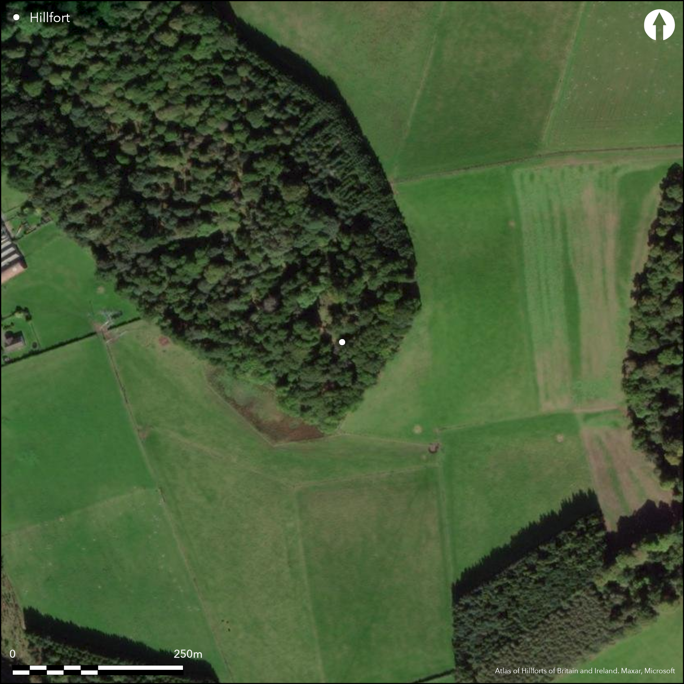
This fort is situated on a steep-sided hillock at what is now the SE end of Jackschairs Wood. Oval on plan, it measures 70m from NE to SW by 50m transversely (0.27ha) within up to four ramparts with intermediate ditches. The ramparts are largely reduced to terraces, the two inner of which can be traced around the whole circuit. The outer two are visible only on the E and S quarters, the outermost on the E a counterscarp rampart overlain by an old plantation bank, and while there is no trace of either on the steep SW flank of the hillock, they may have been ploughed out in the saddle on the NW. An entrance on the E is probably original, though its outer end has been mutilated by the insertion of a water tank into the outer ditch on the S side of the gap, but a second gap on the SE is of relatively recent date. The ground within the interior rises into a low summit around the margins of which there are traces of at least three probable house-platforms, one on the W possibly overlying the tail of the inner rampart. An evaluation trench excavated across the defences on the NE shows that the inner rampart was stone-faced, and the excavators speculated that a post-hole in the top of the inner rampart, and settings of stones on the two outside it, possibly indicated the presence of timber palisades.
Citizen Science: ✗
Reliability of Data: Confirmed
Reliability of Interpretation: Confirmed
X: -389904 Y: 7625295 (EPSG: 3857)
Longitude: -3.502571215709886 Latitude: 56.334496561061584 (EPSG:4326)
Country: Scotland
Current County or Unitary Authority: Perth & Kinross
Historic County: Perthshire
Current Parish/Community/Council/Townland: Forgandenny
None
| Extant | ✓ |
| Cropmark | ✗ |
| Likely Destroyed | ✗ |
None
| Woodland | ✓ |
| Commercial Forestry Plantation | ✗ |
| Parkland | ✗ |
| Pasture (Grazing) | ✗ |
| Arable | ✗ |
| Scrub/Bracken | ✗ |
| Bare Outcrop | ✗ |
| Heather/Moorland | ✗ |
| Heath | ✗ |
| Built-up | ✗ |
| Coastal Grassland | ✗ |
| Other | ✗ |
None
| Contour Fort | ✓ |
| Partial Contour Fort | ✗ |
| Promontory Fort | ✗ |
| Hillslope Fort | ✗ |
| Level Terrain Fort | ✗ |
| Marsh Fort | ✗ |
| Multiple Enclosure Fort | ✗ |
| Hilltop | ✗ |
| Coastal Promontory | ✗ |
| Inland Promontory | ✗ |
| Valley Bottom | ✗ |
| Knoll/Hillock/Outcrop | ✓ |
| Ridge | ✗ |
| Cliff/Plateau-edge/Scarp | ✗ |
| Hillslope | ✗ |
| Lowland | ✗ |
| Spur | ✗ |
Dominant Topographic Feature: None
| North | ✗ |
| Northeast | ✗ |
| East | ✗ |
| Southeast | ✗ |
| South | ✗ |
| Southwest | ✗ |
| West | ✗ |
| Northwest | ✗ |
| Level | ✓ |
Altitude: 90.0m
N/A
Dates from the excavations have yet to be published
Reliability: D - None
| Pre 1200BC | ✗ |
| 1200BC - 800BC | ✗ |
| 800BC - 400BC | ✗ |
| 400BC - AD50 | ✗ |
| AD50 - AD400 | ✗ |
| AD400 - AD 800 | ✗ |
| Post AD800 | ✗ |
| Unknown | ✓ |
| Pre Hillfort: | None |
| Post Hillfort: | Planted with trees and overlain by water tank |
| C14: | Unpublished dates |
None
| 1st Identified Written Reference (1792): | Noted (Stat Acct, iii, 1792, 308) |
| Other (1832): | Description by William Skene (1857, 276-7) |
| 1st Identified Map Depiction (1859): | Annotated Fort on the 1st edition OS 25-inch map (Perth and Clackmannan 1866, sheet 109.7; Name Book, Perthsjire, No.28, p 20) |
| Other (1900): | Visited by David Christison (1900, 106) |
| Other (1956): | Visited for RCAHMS Survey of Marginal Lands |
| Other (1965): | Resurveyed at 1:2500 by the OS |
| Other (1992): | Scheduled |
| Other (1995): | Visited by RCAHMS |
| Excavation (2007): | Directed by Tessa Poller on behalf of the Glasgow University SERF project (Poller et al 2007; Poller and Goldberg 2007) |
| Earthwork Survey (2007): | Terrain model and description (Huggett 2997; Poller and Goldberg 2007, 3, fig 1) |
| Earthwork Survey (2014): | Plan and description (RCAHMS DC57640 & SC1462080, SC1430384) |
Three possible house platforms
None
| None | ✓ |
| Spring | ✗ |
| Stream | ✗ |
| Pool | ✗ |
| Flush | ✗ |
| Well | ✗ |
| Other | ✗ |
Three
| No Known Features | ✗ |
| Round Stone Structures | ✗ |
| Rectangular Stone Structures | ✗ |
| Curvilinear Platforms | ✓ |
| Other Roundhouse Evidence | ✗ |
| Pits | ✗ |
| Quarry Hollows | ✗ |
| Other | ✗ |
Paving
| No Known Excavation | ✗ |
| Pits | ✓ |
| Postholes | ✗ |
| Roundhouses | ✗ |
| Rectangular Structures | ✗ |
| Roads/Tracks | ✗ |
| Quarry Hollows | ✗ |
| Other | ✓ |
| Nothing Found | ✗ |
None
| No Known Geophysics | ✓ |
| Pits | ✗ |
| Roundhouses | ✗ |
| Rectangular Structures | ✗ |
| Roads/Tracks | ✗ |
| Quarry Hollows | ✗ |
| Other | ✗ |
| Nothing Found | ✗ |
Small assemblage of pottery, coarse stone tools and fragments of burnt bone.
| No Known Finds | ✗ |
| Pottery | ✓ |
| Metal | ✗ |
| Metalworking | ✗ |
| Human Bones | ✗ |
| Animal Bones | ✓ |
| Lithics | ✓ |
| Environmental | ✗ |
| Other | ✗ |
Obscured by trees
| APs Not Checked | ✗ |
| None | ✓ |
| Roundhouses | ✗ |
| Rectangular Structures | ✗ |
| Pits | ✗ |
| Postholes | ✗ |
| Roads/Tracks | ✗ |
| Other | ✗ |
See main summary
| 2: | None |
| 2: | None |
Guard Chambers: ✗
Chevaux de Frise: ✗
| 1. Simple Gap (East): | Piercing all ramparts |
Three ramparts and ditches with an outermost counterscarp bank
| Area 1: | 0.27ha. |
| Total: | 0.27ha. |
Total Footprint Area: Noneha.
None
| ✗ | None |
| ✓ | None |
| NE Quadrant: | 3 |
| SE Quadrant: | 3 |
| SW Quadrant: | 2 |
| NW Quadrant: | 2 |
| Total: | 3 |
| Partial Univallate | ✗ |
| Univallate | ✗ |
| Partial Bivallate | ✓ |
| Bivallate | ✗ |
| Partial Multivallate | ✓ |
| Multivallate | ✗ |
| Unknown | ✗ |
| Partial Univallate | ✗ |
| Univallate | ✗ |
| Partial Bivallate | ✗ |
| Bivallate | ✗ |
| Partial Multivallate | ✗ |
| Multivallate | ✗ |
None
| None | ✗ |
| Earthen Bank | ✓ |
| Stone Wall | ✗ |
| Rubble | ✗ |
| Wall-walk | ✗ |
| Evidence of Timber | ✗ |
| Vitrification | ✗ |
| Other Burning | ✗ |
| Palisade | ✗ |
| Counter Scarp Bank | ✓ |
| Berm | ✗ |
| Unfinished | ✗ |
| Other | ✗ |
Ditches
| None | ✗ |
| Earthen Bank | ✓ |
| Stone Wall | ✓ |
| Murus Duplex | ✗ |
| Timber-framed | ✗ |
| Timber-laced | ✗ |
| Vitrification | ✗ |
| Other Burning | ✗ |
| Palisade | ✓ |
| Counter Scarp Bank | ✓ |
| Berm | ✗ |
| Unfinished | ✗ |
| No Known Excavation | ✗ |
| Other | ✓ |
| ✗ | None |
| ✓ | None |
Number of Ditches: 3
| ✗ | None |
Christison, D (1900) 'The forts, "camps", and other field-works of Perth, Forfar and Kincardine'. Proc Soc Antiq Scot 34 (1899-1900), 43-120
Huggett, J (2007) 'The Strathearn Environs and Royal Forteviot Project (SERF) - Jackschairs Hillfort, Perth and Kinross (Forgandenny parish), survey'. Disc Exc Scot, New ser, 8 (2007), 155
Name Book, Ordnance Survey Object Name Books (6 inch and 1/2500 scale); available https://www.scotlandsplaces.gov.uk/
Poller, T and Goldberg, M (2007) Jackschairs Wood Hillfort Excavations 2007; Data Structure Report (Glasgow University, SERF)
Poller, Goldberg and Driscoll, T, M and S (2007) 'The Strathearn Environs and Royal Forteviot Project (SERF) - Jackschairs Hillfort, Perth and Kinross (Forgandenny parish), excavation'. Disc Exc Scot, New Ser, 8, 155-6
Stat Acct (date) Statistical Account of Scotland: Drawn up from the Communications of the Ministers of the Different Parishes (Sinclair, J ed), 1791-99
Skene, W F (1857) 'Observations on Forteviot, the site of the ancient Capital of Scotland', Archaeologia Scotica 4 (1857), 271-9
Atlas of Hillforts:
Wikidata:
This work is licensed under CC BY-SA 4.0![]()
![]()
![]() and should be cited as:
and should be cited as:
Lock, Gary and Ralston, Ian. 2024. Atlas of Hillforts of Britain and Ireland. Available at: https://hillforts.arch.ox.ac.uk
Document Version 1.1