
LiDAR 1m DTM Hillshade
Satellite Imagery
LiDAR 1m DTM Hillshade
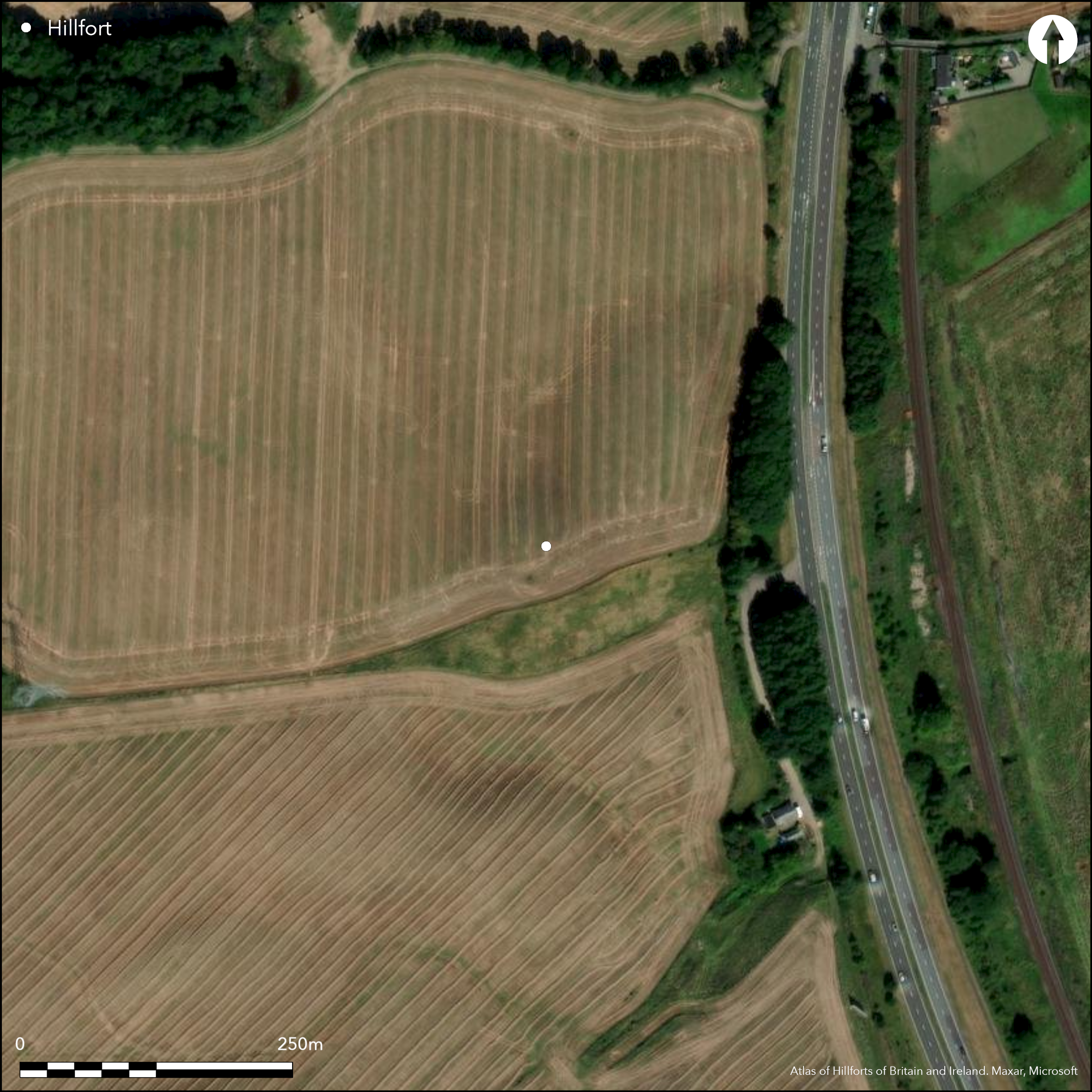
Satellite Imagery
Scroll left/right to view further images.
HER: Perth and Kinross Heritage Trust MPK2051 (None)
NMR: NO 02 NE 28 (26737)
SM: None
NGR: NO 0911 2788
X: 309110 Y: 727880 (OSGB36)
The site of this fort is revealed by cropmarks on the crest of a sinuous ridge of glacial gravels and sands overlooking the A9 carriageway at the apex of the first major westward meander in the River Tay N of Perth. Roughly oval on plan, with a hollow forming a shallow re-entrant in the N flank of the ridge distorting the shape a little on this side, the interior measures about 95m from ENE to WSW by 50m transversely (0.3ha) within a multivallate defence which is most clearly defined to either side of the entrance on the NE, where no fewer than four ditches are visible. The third of these ditches appears to be an enhancement of the defences adjacent to the entrance, petering out into the re-entrant on the N, but traces of the other three ditches extend along this side, and the two inner ones certainly complete the circuit around the SW and SE. The ill-defined character of the cropmarks in these other sectors may have obscured other entrances, though there was possibly a gap in the circuit on the W, and another in the second ditch on the W, immediately N of the point where the third ditch apparently turns inwards to flank its S side; if this was indeed an entrance, it is blocked by the inner ditch, suggesting some depth to the chronology of the defences. Other hints that the defences have been remodelled on at least one occasion, can be seen in the projecting lobes on the terminals of particularly the inner and third ditches on the NE side of the entrance, which suggest episodes of re-cutting. No features can be distinguished in the interior, but the bleached outline of the wallhead of a souterrain can be detected in the second ditch on the NE side of the entrance, probably representing an occupation in the 1st and 2nd centuries AD after the defences had gone out of use.
Citizen Science: ✗
Reliability of Data: Confirmed
Reliability of Interpretation: Confirmed
X: -386895 Y: 7645379 (EPSG: 3857)
Longitude: -3.4755325374105785 Latitude: 56.43438033388761 (EPSG:4326)
Country: Scotland
Current County or Unitary Authority: Perth & Kinross
Historic County: Perthshire
Current Parish/Community/Council/Townland: Redgorton
None
| Extant | ✗ |
| Cropmark | ✓ |
| Likely Destroyed | ✗ |
None
| Woodland | ✗ |
| Commercial Forestry Plantation | ✗ |
| Parkland | ✗ |
| Pasture (Grazing) | ✗ |
| Arable | ✓ |
| Scrub/Bracken | ✗ |
| Bare Outcrop | ✗ |
| Heather/Moorland | ✗ |
| Heath | ✗ |
| Built-up | ✗ |
| Coastal Grassland | ✗ |
| Other | ✗ |
None
| Contour Fort | ✓ |
| Partial Contour Fort | ✗ |
| Promontory Fort | ✗ |
| Hillslope Fort | ✗ |
| Level Terrain Fort | ✗ |
| Marsh Fort | ✗ |
| Multiple Enclosure Fort | ✗ |
| Hilltop | ✗ |
| Coastal Promontory | ✗ |
| Inland Promontory | ✗ |
| Valley Bottom | ✗ |
| Knoll/Hillock/Outcrop | ✓ |
| Ridge | ✗ |
| Cliff/Plateau-edge/Scarp | ✗ |
| Hillslope | ✗ |
| Lowland | ✗ |
| Spur | ✗ |
Dominant Topographic Feature: None
| North | ✗ |
| Northeast | ✗ |
| East | ✗ |
| Southeast | ✗ |
| South | ✗ |
| Southwest | ✗ |
| West | ✗ |
| Northwest | ✗ |
| Level | ✓ |
Altitude: 37.0m
N/A
The souterrain indicates the defences were out of use by the early centuries AD
Reliability: D - None
| Pre 1200BC | ✗ |
| 1200BC - 800BC | ✗ |
| 800BC - 400BC | ✗ |
| 400BC - AD50 | ✗ |
| AD50 - AD400 | ✗ |
| AD400 - AD 800 | ✗ |
| Post AD800 | ✗ |
| Unknown | ✓ |
| Pre Hillfort: | None |
| Post Hillfort: | Souterrain cut into one of the ditches, but defences ploughed flat |
Photographed by CUCAP in 1961, 1967, 1968, 1970 and 1981 John Dewar in 1975 (held by RCAHMS) and the RCAHMS Aerial Survey Programme in 1977, 1979, 1981, 1982, 1983, 1984, 1986, 1987 , 1988, 1989, 1992, 1993, 1999, 2000 and 2003
| 1st Identified Written Reference (1961): | Photographed by CUCAP |
Featureless
None
| None | ✓ |
| Spring | ✗ |
| Stream | ✗ |
| Pool | ✗ |
| Flush | ✗ |
| Well | ✗ |
| Other | ✗ |
None
| No Known Features | ✓ |
| Round Stone Structures | ✗ |
| Rectangular Stone Structures | ✗ |
| Curvilinear Platforms | ✗ |
| Other Roundhouse Evidence | ✗ |
| Pits | ✗ |
| Quarry Hollows | ✗ |
| Other | ✗ |
None
| No Known Excavation | ✓ |
| Pits | ✗ |
| Postholes | ✗ |
| Roundhouses | ✗ |
| Rectangular Structures | ✗ |
| Roads/Tracks | ✗ |
| Quarry Hollows | ✗ |
| Other | ✗ |
| Nothing Found | ✗ |
None
| No Known Geophysics | ✓ |
| Pits | ✗ |
| Roundhouses | ✗ |
| Rectangular Structures | ✗ |
| Roads/Tracks | ✗ |
| Quarry Hollows | ✗ |
| Other | ✗ |
| Nothing Found | ✗ |
None
| No Known Finds | ✓ |
| Pottery | ✗ |
| Metal | ✗ |
| Metalworking | ✗ |
| Human Bones | ✗ |
| Animal Bones | ✗ |
| Lithics | ✗ |
| Environmental | ✗ |
| Other | ✗ |
NO APPARENT FEATURES
| APs Not Checked | ✗ |
| None | ✓ |
| Roundhouses | ✗ |
| Rectangular Structures | ✗ |
| Pits | ✗ |
| Postholes | ✗ |
| Roads/Tracks | ✗ |
| Other | ✗ |
See main summary
| 3: | But ploughed flat |
| 2: | None |
Guard Chambers: ✗
Chevaux de Frise: ✗
| 1. Simple Gap (North east): | Sector with an additional ditch; pierces the whole belt of defences |
| 2. Simple Gap (East): | Possible gap in the 2nd ditch; if so blocked by the line of the inner ditch |
| 3. Simple Gap (West): | Hazy impression of a gap in illdefined cropmarks |
Up to four ditches, presumably with upcast ramparts on the NE, but elsewhere no more than three
| Area 1: | 0.3ha. |
| Total: | 0.3ha. |
Total Footprint Area: Noneha.
None
| ✓ | Suggestions of multiperiod defences at the possible entrance on the E and the way that the terminals of the ditches at the NE entrance have projecting lobes, indicating possible recuts |
| ✓ | None |
| NE Quadrant: | 4 |
| SE Quadrant: | 2 |
| SW Quadrant: | 2 |
| NW Quadrant: | 3 |
| Total: | 4 |
| Partial Univallate | ✗ |
| Univallate | ✗ |
| Partial Bivallate | ✓ |
| Bivallate | ✗ |
| Partial Multivallate | ✓ |
| Multivallate | ✗ |
| Unknown | ✗ |
| Partial Univallate | ✗ |
| Univallate | ✗ |
| Partial Bivallate | ✗ |
| Bivallate | ✗ |
| Partial Multivallate | ✗ |
| Multivallate | ✗ |
None
| None | ✓ |
| Earthen Bank | ✗ |
| Stone Wall | ✗ |
| Rubble | ✗ |
| Wall-walk | ✗ |
| Evidence of Timber | ✗ |
| Vitrification | ✗ |
| Other Burning | ✗ |
| Palisade | ✗ |
| Counter Scarp Bank | ✗ |
| Berm | ✗ |
| Unfinished | ✗ |
| Other | ✗ |
None
| None | ✗ |
| Earthen Bank | ✗ |
| Stone Wall | ✗ |
| Murus Duplex | ✗ |
| Timber-framed | ✗ |
| Timber-laced | ✗ |
| Vitrification | ✗ |
| Other Burning | ✗ |
| Palisade | ✗ |
| Counter Scarp Bank | ✗ |
| Berm | ✗ |
| Unfinished | ✗ |
| No Known Excavation | ✓ |
| Other | ✗ |
| ✗ | None |
| ✓ | None |
Number of Ditches: 4
| ✗ | None |
No related records
Atlas of Hillforts:
Wikidata:
This work is licensed under CC BY-SA 4.0![]()
![]()
![]() and should be cited as:
and should be cited as:
Lock, Gary and Ralston, Ian. 2024. Atlas of Hillforts of Britain and Ireland. Available at: https://hillforts.arch.ox.ac.uk
Document Version 1.1