LiDAR 1m DTM Hillshade

Satellite Imagery
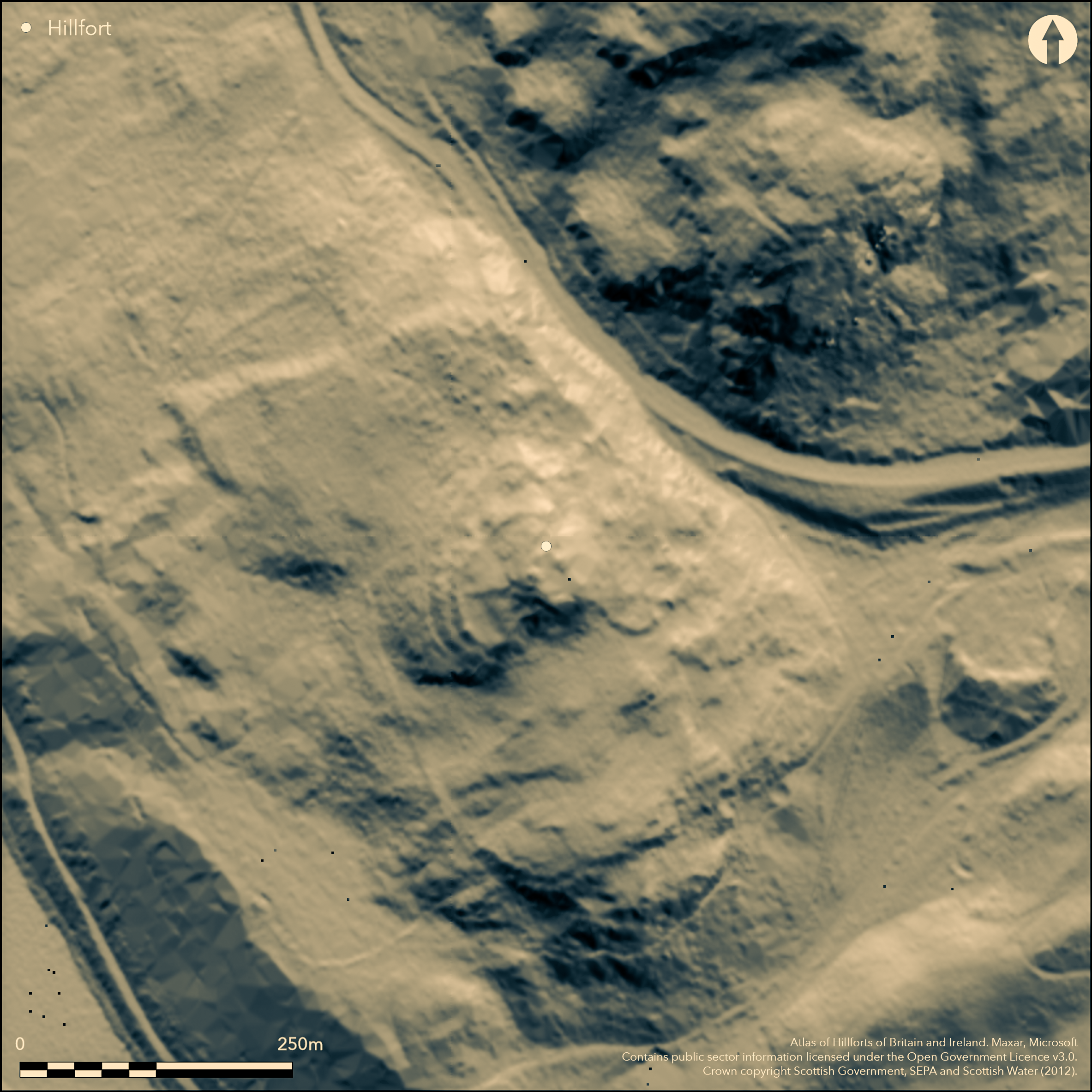
LiDAR 1m DTM Hillshade
Satellite Imagery
Scroll left/right to view further images.
HER: Perth and Kinross Heritage Trust MPK5444 (None)
NMR: NO 04 SW 19 (27172)
SM: 1598
NGR: NO 0094 4300
X: 300940 Y: 743000 (OSGB36)
This fort is situated in the tangled woodland and undergrowth that clothes the King's Seat, a craggy hill commanding the narrow exit of the River Tay from the highlands beyond the facade formed by the Highland Boundary Fault at Dunkeld. Translated by William Watson as 'the Fort of the Caledonians', its defences appear to comprise several elements descending from an oval enclosure on the summit, and are usually conceived as a citadel with subsidiary enclosures, though there is no secure evidence to sustain this interpretation. The summit enclosure measures 35m from N to S by 22m transversely (0.06ha) within the remains of what is probably a thick wall; an entrance on the N opens onto a trackway dropping down at the rear of a second wall or rampart to a lower terrace on the W. This second rampart extends along the lip of the terace before returning back up the edge of the crag on the S to the summit to enclose an overall area measuring 55m from NE to SW by 45m transversely (2.2ha). Immediately below this rampart on the W there is a flight of what appear to be three ramparts with internal quarry ditches, though curiously they seem only to block access up the very steepest slopes, petering out on the gentler ground to the N, and it is possible that these are an antiquarian confection to enhance the presence of the fort in the designed landscape of paths and walks laid out in the policies of Dunkeld House. Nevertheless, a short length of rampart can be seen on a terrace below the summit on the N, and from the foot of the outcrops on its NE another thick bank surmounted by a narrow wall loops out to take in a lower terrace below the crags to form an annexe measuring about 90m from NNW to SSE by 40m transversely (0.35ha). The modern pathway that mounts the summit via these terraces is perhaps marking the original route into the interior.
Citizen Science: ✗
Reliability of Data: Confirmed
Reliability of Interpretation: Confirmed
X: -402278 Y: 7672435 (EPSG: 3857)
Longitude: -3.6137249742459985 Latitude: 56.568521133171615 (EPSG:4326)
Country: Scotland
Current County or Unitary Authority: Perth & Kinross
Historic County: Perthshire
Current Parish/Community/Council/Townland: Dunkeld And Dowally
None
| Extant | ✓ |
| Cropmark | ✗ |
| Likely Destroyed | ✗ |
None
| Woodland | ✓ |
| Commercial Forestry Plantation | ✗ |
| Parkland | ✗ |
| Pasture (Grazing) | ✗ |
| Arable | ✗ |
| Scrub/Bracken | ✓ |
| Bare Outcrop | ✗ |
| Heather/Moorland | ✗ |
| Heath | ✗ |
| Built-up | ✗ |
| Coastal Grassland | ✗ |
| Other | ✗ |
None
| Contour Fort | ✓ |
| Partial Contour Fort | ✓ |
| Promontory Fort | ✗ |
| Hillslope Fort | ✗ |
| Level Terrain Fort | ✗ |
| Marsh Fort | ✗ |
| Multiple Enclosure Fort | ✓ |
| Hilltop | ✗ |
| Coastal Promontory | ✗ |
| Inland Promontory | ✗ |
| Valley Bottom | ✗ |
| Knoll/Hillock/Outcrop | ✓ |
| Ridge | ✗ |
| Cliff/Plateau-edge/Scarp | ✗ |
| Hillslope | ✗ |
| Lowland | ✗ |
| Spur | ✗ |
Dominant Topographic Feature: None
| North | ✗ |
| Northeast | ✗ |
| East | ✗ |
| Southeast | ✗ |
| South | ✗ |
| Southwest | ✗ |
| West | ✓ |
| Northwest | ✗ |
| Level | ✗ |
Altitude: 150.0m
N/A
In the absence of excavation, there are neither stratified artefacts nor radiocarbon dates to provide a chronology for the defences.
Reliability: D - None
| Pre 1200BC | ✗ |
| 1200BC - 800BC | ✗ |
| 800BC - 400BC | ✗ |
| 400BC - AD50 | ✗ |
| AD50 - AD400 | ✗ |
| AD400 - AD 800 | ✗ |
| Post AD800 | ✗ |
| Unknown | ✓ |
| Pre Hillfort: | None |
| Post Hillfort: | Planted with trees |
None
| 1st Identified Map Depiction (1863): | Annotated 'Site of Castle' in woodland on the 1st edition OS 25-inch map (Perth and Clackmannan 1867, sheet 61.8) |
| 1st Identified Written Reference (1926): | Place-name (Watson 1926, 21-2) |
| Earthwork Survey (1957): | Plan and description for RCAHMS Survey of Marginal Lands (RCAHMS PTD 223/1-2 & DP094926; DC5384-6; Feachem 1966, 75, fig 11) |
| Other (1960): | Scheduled |
| Other (1971): | Surveyed at 1:10,000 by the OS |
| Earthwork Survey (1989): | Plan and description, redrawn in the field in dense woodland and scrub from earlier RCAHMS plan (RCAHMS DC25077-8 & DP094925, DC25087; RCAHMS 1994, 51, 53) |
| Other (2011): | Re-Scheduled |
Featureless, unless the 'citadel is a later dun inserted into an earlier fortification
None
| None | ✓ |
| Spring | ✗ |
| Stream | ✗ |
| Pool | ✗ |
| Flush | ✗ |
| Well | ✗ |
| Other | ✗ |
None
| No Known Features | ✓ |
| Round Stone Structures | ✗ |
| Rectangular Stone Structures | ✗ |
| Curvilinear Platforms | ✗ |
| Other Roundhouse Evidence | ✗ |
| Pits | ✗ |
| Quarry Hollows | ✗ |
| Other | ✗ |
None
| No Known Excavation | ✓ |
| Pits | ✗ |
| Postholes | ✗ |
| Roundhouses | ✗ |
| Rectangular Structures | ✗ |
| Roads/Tracks | ✗ |
| Quarry Hollows | ✗ |
| Other | ✗ |
| Nothing Found | ✗ |
None
| No Known Geophysics | ✓ |
| Pits | ✗ |
| Roundhouses | ✗ |
| Rectangular Structures | ✗ |
| Roads/Tracks | ✗ |
| Quarry Hollows | ✗ |
| Other | ✗ |
| Nothing Found | ✗ |
None
| No Known Finds | ✓ |
| Pottery | ✗ |
| Metal | ✗ |
| Metalworking | ✗ |
| Human Bones | ✗ |
| Animal Bones | ✗ |
| Lithics | ✗ |
| Environmental | ✗ |
| Other | ✗ |
Obscured by trees
| APs Not Checked | ✗ |
| None | ✓ |
| Roundhouses | ✗ |
| Rectangular Structures | ✗ |
| Pits | ✗ |
| Postholes | ✗ |
| Roads/Tracks | ✗ |
| Other | ✗ |
See main summary
| 1: | None |
| 2: | None |
Guard Chambers: ✗
Chevaux de Frise: ✗
| 1. Simple Gap (North): | Inner enclosure |
Series of stony ramparts forming a summit enclosure and a subsidiary outer enclosure, with a flight of three ramparts reduced to terraces on the steepest side.
| Area 1: | 0.06ha. |
| Area 2: | 0.22ha. |
| Total: | 0.22ha. |
Total Footprint Area: Noneha.
None
| ✗ | None |
| ✓ | None |
| NE Quadrant: | 2 |
| SE Quadrant: | 1 |
| SW Quadrant: | 5 |
| NW Quadrant: | 3 |
| Total: | 5 |
| Partial Univallate | ✓ |
| Univallate | ✗ |
| Partial Bivallate | ✓ |
| Bivallate | ✗ |
| Partial Multivallate | ✓ |
| Multivallate | ✗ |
| Unknown | ✗ |
| Partial Univallate | ✗ |
| Univallate | ✓ |
| Partial Bivallate | ✗ |
| Bivallate | ✗ |
| Partial Multivallate | ✗ |
| Multivallate | ✗ |
None
| None | ✗ |
| Earthen Bank | ✓ |
| Stone Wall | ✓ |
| Rubble | ✗ |
| Wall-walk | ✗ |
| Evidence of Timber | ✗ |
| Vitrification | ✗ |
| Other Burning | ✗ |
| Palisade | ✗ |
| Counter Scarp Bank | ✗ |
| Berm | ✗ |
| Unfinished | ✗ |
| Other | ✗ |
None
| None | ✗ |
| Earthen Bank | ✗ |
| Stone Wall | ✗ |
| Murus Duplex | ✗ |
| Timber-framed | ✗ |
| Timber-laced | ✗ |
| Vitrification | ✗ |
| Other Burning | ✗ |
| Palisade | ✗ |
| Counter Scarp Bank | ✗ |
| Berm | ✗ |
| Unfinished | ✗ |
| No Known Excavation | ✓ |
| Other | ✗ |
| ✗ | None |
| ✗ | None |
Number of Ditches: None
| ✓ | A bank up to 5m in thickness by 1.2m in height, which is also surmounted by a narrow wall, loops out at the foot of the crags on the NE to take in a lower terrace measuring about 90m from NNW to SSE by 40m transversely (0.35ha). |
Feachem, R W (1966) 'The hill-forts of northern Britain'. In Rivet, A L F (ed) The iron age in northern Britain. Edinburgh University Press Edinburgh
RCAHMS (1994) The Royal Commission on the Ancient and Historical Monuments of Scotland. South-east Perth: an archaeological landscape. HMSO: Edinburgh
Watson, W J (1926) The history of the Celtic place-names of Scotland: being the Rhind lectures on archaeology (expanded) delivered in 1916. Edinburgh
Atlas of Hillforts:
Wikidata:
This work is licensed under CC BY-SA 4.0![]()
![]()
![]() and should be cited as:
and should be cited as:
Lock, Gary and Ralston, Ian. 2024. Atlas of Hillforts of Britain and Ireland. Available at: https://hillforts.arch.ox.ac.uk
Document Version 1.1