Satellite Imagery
Satellite Imagery
HER: Perth and Kinross Heritage Trust MPK3069 (None)
NMR: NO 11 NE 12 (27917)
SM: 2477
NGR: NO 1830 1533
X: 318300 Y: 715330 (OSGB36)
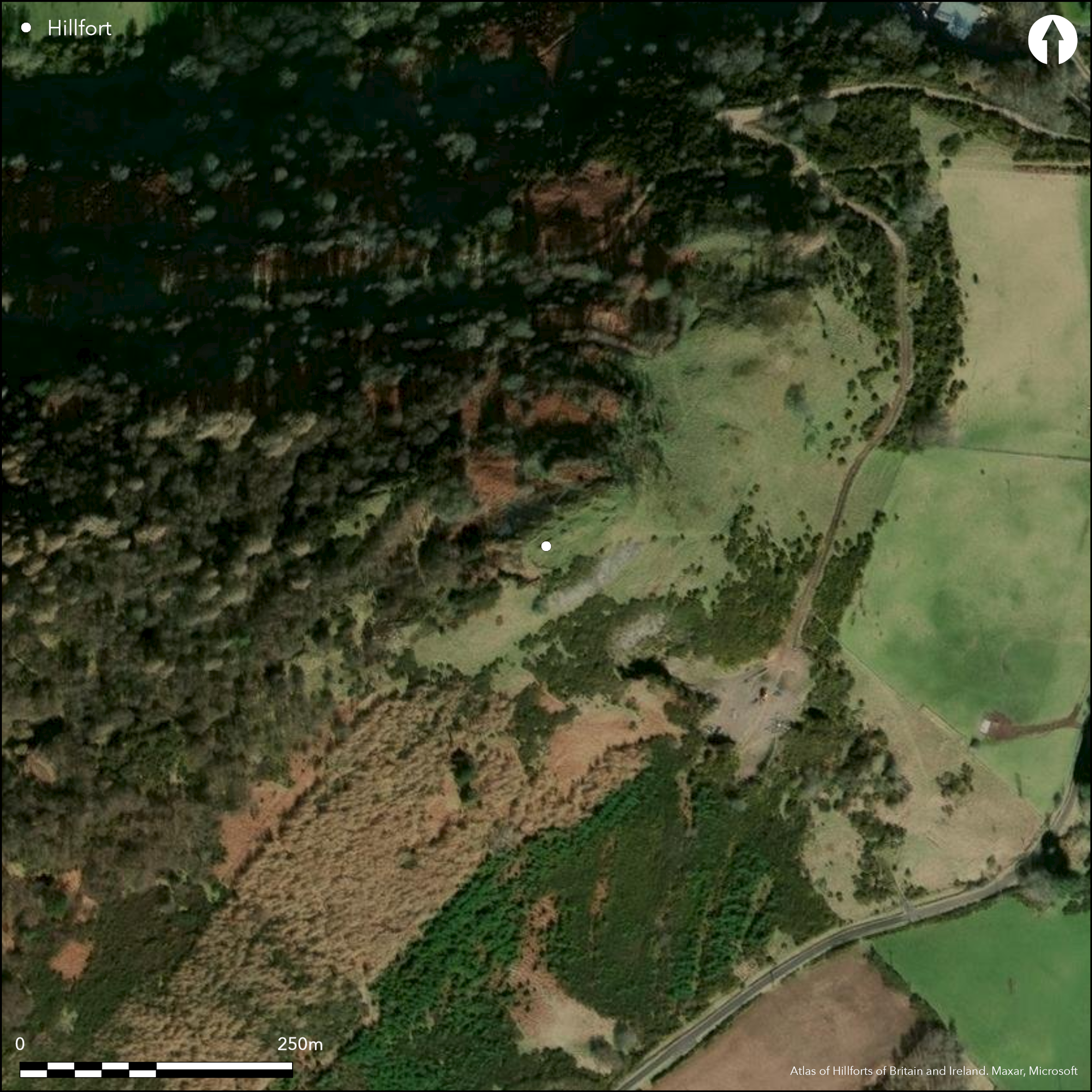
This small fortification is situated on a rocky knoll that forms the tip of the NE spur of Castle Law, from which the ground falls away steeply into the valley of the Ballo Burn on the E and to the floodplain of the River Tay on the N. But for the excavations carried out by two local men about 1895-7, completed by the Society of Antiquaries in 1898, it is unlikely that the fort would have assumed any significance in the study Scottish hillforts. Nevertheless, the excavations uncovered what appears to have been a thick timber-laced wall enclosing an oval area measuring 43m from NE to SW by 15.5m transversely (0.06ha); tiers of openings were exposed in the outer face of the wall, which on the SW measures about 6m in thickness and still stands 2.4m high externally. On dismantling parts of the wall they found unfilled channels left by the decayed timbers ran back up to 3m into the core of the wall, where several longitudinal channels were also located. An outer wall at least 4.5m thick, and also timber-laced, cuts eccentrically across the spine of the knoll on the SW and is assumed to be an outwork to the inner wall on this the most accessible side. Large dumps of spoil from the excavations lie to the NW and SW and the interior is scarred with excavation trenches, which revealed a rock-cut cistern on the SE. No trace of an entrance was located. The only other features of note are a dam of unknown date creating a pond in the hollow below the fort on the W, and a second bank crossing the hollow on the lip of the slope to its NE; springing from the foot of the scree of debris below the NW flank fort on the SE, and resting on the end of a spine of outcrop on the NW, the purpose of the latter is unknown.
Citizen Science: ✗
Reliability of Data: Confirmed
Reliability of Interpretation: Confirmed
X: -369874 Y: 7623055 (EPSG: 3857)
Longitude: -3.322635735792908 Latitude: 56.323339554149065 (EPSG:4326)
Country: Scotland
Current County or Unitary Authority: Perth & Kinross
Historic County: Perthshire
Current Parish/Community/Council/Townland: Abernethy
None
| Extant | ✓ |
| Cropmark | ✗ |
| Likely Destroyed | ✗ |
None
| Woodland | ✓ |
| Commercial Forestry Plantation | ✗ |
| Parkland | ✗ |
| Pasture (Grazing) | ✗ |
| Arable | ✗ |
| Scrub/Bracken | ✓ |
| Bare Outcrop | ✗ |
| Heather/Moorland | ✗ |
| Heath | ✗ |
| Built-up | ✗ |
| Coastal Grassland | ✗ |
| Other | ✗ |
None
| Contour Fort | ✓ |
| Partial Contour Fort | ✗ |
| Promontory Fort | ✗ |
| Hillslope Fort | ✗ |
| Level Terrain Fort | ✗ |
| Marsh Fort | ✗ |
| Multiple Enclosure Fort | ✗ |
| Hilltop | ✗ |
| Coastal Promontory | ✗ |
| Inland Promontory | ✗ |
| Valley Bottom | ✗ |
| Knoll/Hillock/Outcrop | ✓ |
| Ridge | ✗ |
| Cliff/Plateau-edge/Scarp | ✗ |
| Hillslope | ✗ |
| Lowland | ✗ |
| Spur | ✓ |
Dominant Topographic Feature: None
| North | ✗ |
| Northeast | ✗ |
| East | ✗ |
| Southeast | ✗ |
| South | ✗ |
| Southwest | ✗ |
| West | ✗ |
| Northwest | ✗ |
| Level | ✓ |
Altitude: 230.0m
N/A
Bronze spiral finger ring; La Tene 1 fibula, and a ringheaded pin
Reliability: D - None
| Pre 1200BC | ✗ |
| 1200BC - 800BC | ✗ |
| 800BC - 400BC | ✗ |
| 400BC - AD50 | ✗ |
| AD50 - AD400 | ✗ |
| AD400 - AD 800 | ✗ |
| Post AD800 | ✗ |
| Unknown | ✓ |
| Pre Hillfort: | Polished stone axe |
| Post Hillfort: | None |
| Artefactual: | Bronze spiral finger ring |
RCAHMS also hold oblique aerial photographs taken by both CUCAP and RCAHMS Aerial Survey Programme, and ground views taken by Helen Nisbet in 1968
| 1st Identified Written Reference (1794): | Noted (Stat Acct, xi, 1794, 447-8) |
| 1st Identified Written Reference (1842): | Description (NSA, x, Perthshire), 151-2 |
| 1st Identified Map Depiction (1860): | Annotated Fort on the 1st edition OS 25-inch map (Perth and Clackmannan 1866, sheet 110.12) |
| Excavation (1898): | Over three years by Alexander Mackie and James Marr (Christison and Anderson 1899, 17 fig 3) |
| Earthwork Survey (1898): | Plan (Christison and Anderson 1899, 16 fig 2) |
| Other (1964): | Scheduled |
| Other (1965): | Surveyed at 1:2500 by the OS |
| Other (1996): | Visited by RCAHMS |
| Earthwork Survey (2012): | Plan (Oxford North 2012, fig 2) |
| Earthwork Survey (2013): | Plan and description (RCAHMS DC49500 & SC1346483; GV005170 & SC1348103 |
Scarred by excavation trenches
None
| None | ✗ |
| Spring | ✗ |
| Stream | ✗ |
| Pool | ✗ |
| Flush | ✗ |
| Well | ✓ |
| Other | ✗ |
Only the cistern is visible
| No Known Features | ✗ |
| Round Stone Structures | ✗ |
| Rectangular Stone Structures | ✗ |
| Curvilinear Platforms | ✗ |
| Other Roundhouse Evidence | ✗ |
| Pits | ✗ |
| Quarry Hollows | ✗ |
| Other | ✓ |
None
| No Known Excavation | ✓ |
| Pits | ✗ |
| Postholes | ✗ |
| Roundhouses | ✗ |
| Rectangular Structures | ✗ |
| Roads/Tracks | ✗ |
| Quarry Hollows | ✗ |
| Other | ✗ |
| Nothing Found | ✗ |
None
| No Known Geophysics | ✓ |
| Pits | ✗ |
| Roundhouses | ✗ |
| Rectangular Structures | ✗ |
| Roads/Tracks | ✗ |
| Quarry Hollows | ✗ |
| Other | ✗ |
| Nothing Found | ✗ |
Finds held in NMAS: GP 17-18 stone lamps; GP 20 hammerstone; GP 21 grooved piece of sandstone; GP 22 polisher of jet; GP 23-4 clay peelets; GP 25-6 chips of flint; GP 27-34 jet ring and fragment, bronze finger-ring, bronze fibula, rubbed bone fragements; GP 35-40 iron objects; GP 41-2 portions of two wooden vessels; GP 43 bone tool handle; GP 44-6 jaw bones of ox; GP 47 horn cores of goat; GP 48 tine of roe-deer; GP 49 leg-bone of ox; GP 50-4 bones, artifically split; GP 55 four small fragments of coarse pottery.
| No Known Finds | ✗ |
| Pottery | ✓ |
| Metal | ✓ |
| Metalworking | ✗ |
| Human Bones | ✗ |
| Animal Bones | ✓ |
| Lithics | ✓ |
| Environmental | ✗ |
| Other | ✓ |
NO APPARENT FEATURES
| APs Not Checked | ✗ |
| None | ✓ |
| Roundhouses | ✗ |
| Rectangular Structures | ✗ |
| Pits | ✗ |
| Postholes | ✗ |
| Roads/Tracks | ✗ |
| Other | ✗ |
None known
| 0: | None |
| 2: | Not known |
Guard Chambers: ✗
Chevaux de Frise: ✗
Single wall with outwork
| Area 1: | 0.06ha. |
| Total: | 0.06ha. |
Total Footprint Area: Noneha.
None
| ✗ | None |
| ✓ | None |
| NE Quadrant: | 1 |
| SE Quadrant: | 1 |
| SW Quadrant: | 2 |
| NW Quadrant: | 1 |
| Total: | 2 |
| Partial Univallate | ✓ |
| Univallate | ✗ |
| Partial Bivallate | ✓ |
| Bivallate | ✗ |
| Partial Multivallate | ✗ |
| Multivallate | ✗ |
| Unknown | ✗ |
| Partial Univallate | ✗ |
| Univallate | ✗ |
| Partial Bivallate | ✗ |
| Bivallate | ✗ |
| Partial Multivallate | ✗ |
| Multivallate | ✗ |
None
| None | ✗ |
| Earthen Bank | ✗ |
| Stone Wall | ✓ |
| Rubble | ✗ |
| Wall-walk | ✗ |
| Evidence of Timber | ✗ |
| Vitrification | ✗ |
| Other Burning | ✗ |
| Palisade | ✗ |
| Counter Scarp Bank | ✗ |
| Berm | ✗ |
| Unfinished | ✗ |
| Other | ✗ |
None
| None | ✗ |
| Earthen Bank | ✗ |
| Stone Wall | ✓ |
| Murus Duplex | ✗ |
| Timber-framed | ✗ |
| Timber-laced | ✓ |
| Vitrification | ✗ |
| Other Burning | ✗ |
| Palisade | ✗ |
| Counter Scarp Bank | ✗ |
| Berm | ✗ |
| Unfinished | ✗ |
| No Known Excavation | ✗ |
| Other | ✗ |
| ✗ | None |
| ✗ | None |
Number of Ditches: None
| ✗ | None |
Christison and Anderson, D and J (1899) 'On the recently excavated fort on Castle Law, Abernethy, Perthshire, with notes on finds. Proc Soc Antiq Scot 33 (1898-9), 3-33
Cotton, M A (1954) 'British camps with timber-laced ramparts'. Archaeol J 111 (1954), 26-105 (p 67)
Feachem, R (1963) A guide to prehistoric Scotland. Batsford: London (p 145)
Feachem, R W (1966) 'The hill-forts of northern Britain', in Rivet, A L F The iron age in northern Britain. EUP: Edinburgh (p 66-8, 75)
Hogg, A H A (1975) Hill-forts of Britain. Hart-Davis, MacGibbon: London (170-1)
NSA (1834-1845) The new statistical account of Scotland by the ministers of the respective parishes under the superintendence of a committee of the society for the benefit of the sons and daughters of the clergy, 15v Edinburgh
Oxford North (2012) Hill-forts of the Inner Tay Estuary, Perth, Perth and Kinross: Phase One. Archaeological Survey Report
Stat Acct (date) Statistical Account of Scotland: Drawn up from the Communications of the Ministers of the Different Parishes (Sinclair, J ed), 1791-99
Atlas of Hillforts:
Wikidata:
This work is licensed under CC BY-SA 4.0![]()
![]()
![]() and should be cited as:
and should be cited as:
Lock, Gary and Ralston, Ian. 2024. Atlas of Hillforts of Britain and Ireland. Available at: https://hillforts.arch.ox.ac.uk
Document Version 1.1