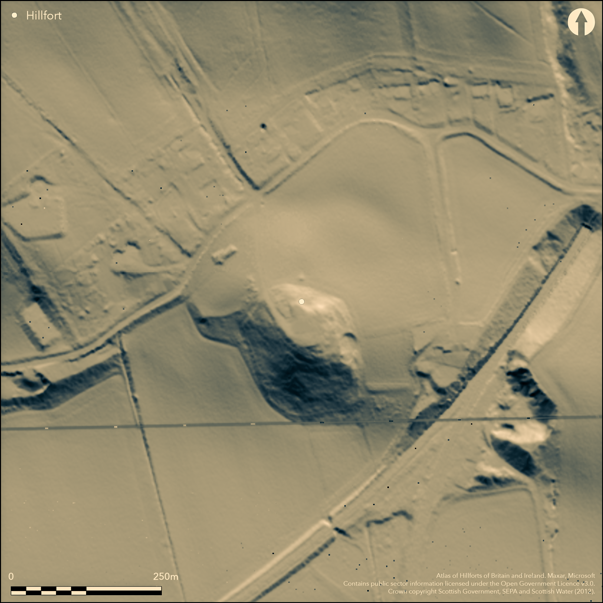
LiDAR 1m DTM Hillshade
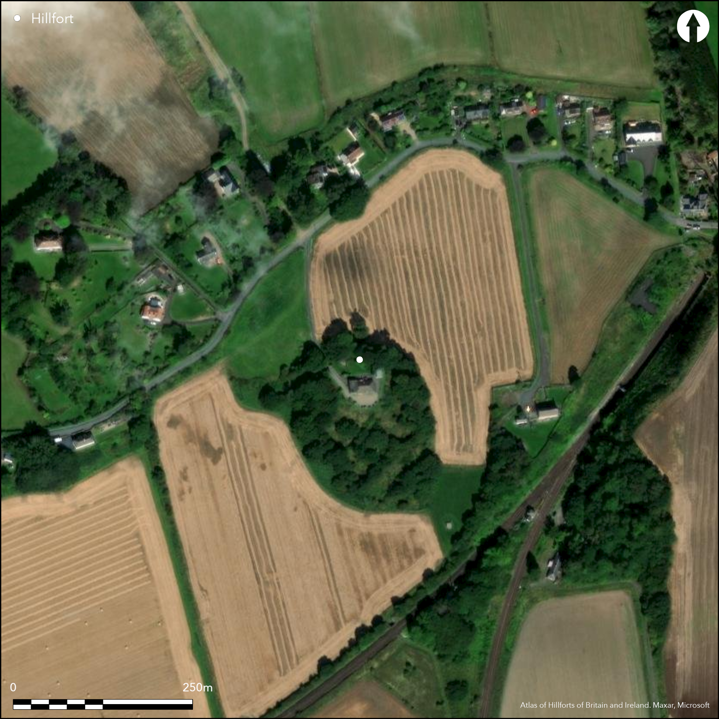
Satellite Imagery
LiDAR 1m DTM Hillshade
Satellite Imagery
Scroll left/right to view further images.
HER: Perth and Kinross Heritage Trust MPK3448 (None)
NMR: NO 12 SW 189 (28352)
SM: None
NGR: NO 1149 2010
X: 311490 Y: 720106 (OSGB36)
Cropmarks have revealed the presence of a fort encircling the hillock surmounted by Hilton House. At least five ditches are present on the NW, extending round onto the NE, but the rest of the hillock is clothed in woodland with a dense understorey. Geophysical survey has confirmed the presence of the ditches elsewhere (Poller 2012) and at least two of the ditches were located in a cable trench on the E (Lewis 2009); more recently traces of the two outermost ramparts on the SW have been recorded within the woodland, while a scarp 2m high on the SE is possibly a fragment of the inner rampart. The projection of the cropmarks, combined with this new survey, suggests that the fort encloses an oval area measuring about 70m from NW to SE by up to 50m transversely (0.27ha), though there may be a rather smaller inner enclosure on the summit. The cropmarks reveal a clear entrance on the NW, to the S of which there may have been a reduction in the number of ditches and ramparts, and there may be a second entrance on the E.
Citizen Science: ✗
Reliability of Data: Confirmed
Reliability of Interpretation: Confirmed
X: -382307 Y: 7631425 (EPSG: 3857)
Longitude: -3.4343220865963615 Latitude: 56.36501128082345 (EPSG:4326)
Country: Scotland
Current County or Unitary Authority: Perth & Kinross
Historic County: Perthshire
Current Parish/Community/Council/Townland: Forgandenny
None
| Extant | ✗ |
| Cropmark | ✓ |
| Likely Destroyed | ✗ |
None
| Woodland | ✓ |
| Commercial Forestry Plantation | ✗ |
| Parkland | ✗ |
| Pasture (Grazing) | ✗ |
| Arable | ✓ |
| Scrub/Bracken | ✗ |
| Bare Outcrop | ✗ |
| Heather/Moorland | ✗ |
| Heath | ✗ |
| Built-up | ✓ |
| Coastal Grassland | ✗ |
| Other | ✗ |
None
| Contour Fort | ✓ |
| Partial Contour Fort | ✗ |
| Promontory Fort | ✗ |
| Hillslope Fort | ✗ |
| Level Terrain Fort | ✗ |
| Marsh Fort | ✗ |
| Multiple Enclosure Fort | ✗ |
| Hilltop | ✗ |
| Coastal Promontory | ✗ |
| Inland Promontory | ✗ |
| Valley Bottom | ✗ |
| Knoll/Hillock/Outcrop | ✓ |
| Ridge | ✗ |
| Cliff/Plateau-edge/Scarp | ✗ |
| Hillslope | ✗ |
| Lowland | ✗ |
| Spur | ✗ |
Dominant Topographic Feature: None
| North | ✗ |
| Northeast | ✗ |
| East | ✗ |
| Southeast | ✗ |
| South | ✗ |
| Southwest | ✗ |
| West | ✗ |
| Northwest | ✗ |
| Level | ✓ |
Altitude: 57.0m
N/A
Radiocarbon dates have yet to be published
Reliability: D - None
| Pre 1200BC | ✗ |
| 1200BC - 800BC | ✗ |
| 800BC - 400BC | ✗ |
| 400BC - AD50 | ✗ |
| AD50 - AD400 | ✗ |
| AD400 - AD 800 | ✗ |
| Post AD800 | ✗ |
| Unknown | ✓ |
| Pre Hillfort: | None |
| Post Hillfort: | Ploughed flat, planted largely with trees and then partly built on |
Photographed on least eight occasions by RCAHMS Aerial Survey Programme since its discovery by John Dewar in 1975
| 1st Identified Written Reference (1975): | First photographed by John Dewar |
| Other (1997): | Description by RCAHMS |
| Excavation (2009): | Watching brief in cable trench (Lewis 2009; RCAHMS MS7070 ) |
| Geophysical Survey (2012): | By Tessa Poller for the Glasgow University SERF project (Poller 2012) |
| Excavation (2013): | Evaluation by Tessa Poller (2014) |
| Earthwork Survey (2015): | Plan and description (RCAHMS SC1495144 & GV005954) |
Featureless
None
| None | ✓ |
| Spring | ✗ |
| Stream | ✗ |
| Pool | ✗ |
| Flush | ✗ |
| Well | ✗ |
| Other | ✗ |
None
| No Known Features | ✓ |
| Round Stone Structures | ✗ |
| Rectangular Stone Structures | ✗ |
| Curvilinear Platforms | ✗ |
| Other Roundhouse Evidence | ✗ |
| Pits | ✗ |
| Quarry Hollows | ✗ |
| Other | ✗ |
None
| No Known Excavation | ✓ |
| Pits | ✗ |
| Postholes | ✗ |
| Roundhouses | ✗ |
| Rectangular Structures | ✗ |
| Roads/Tracks | ✗ |
| Quarry Hollows | ✗ |
| Other | ✗ |
| Nothing Found | ✗ |
Merely the defences
| No Known Geophysics | ✗ |
| Pits | ✗ |
| Roundhouses | ✗ |
| Rectangular Structures | ✗ |
| Roads/Tracks | ✗ |
| Quarry Hollows | ✗ |
| Other | ✓ |
| Nothing Found | ✗ |
None
| No Known Finds | ✓ |
| Pottery | ✗ |
| Metal | ✗ |
| Metalworking | ✗ |
| Human Bones | ✗ |
| Animal Bones | ✗ |
| Lithics | ✗ |
| Environmental | ✗ |
| Other | ✗ |
NO APPARENT FEATURES
| APs Not Checked | ✗ |
| None | ✓ |
| Roundhouses | ✗ |
| Rectangular Structures | ✗ |
| Pits | ✗ |
| Postholes | ✗ |
| Roads/Tracks | ✗ |
| Other | ✗ |
See main summary
| 2: | Incompletely known circuit levelled by cultivation |
| 2: | None |
Guard Chambers: ✗
Chevaux de Frise: ✗
| 1. Simple Gap (East): | None |
| 2. Simple Gap (North west): | Reduction in the number of ditches to the S |
At least five ditches, presumably accompanied y upstanding ramparts
| Area 1: | 0.27ha. |
| Total: | 0.27ha. |
Total Footprint Area: 1.14ha.
None
| ✗ | None |
| ✗ | Probably a complete circuit but only part known from cropmarks |
| NE Quadrant: | 5 |
| SE Quadrant: | 0 |
| SW Quadrant: | 0 |
| NW Quadrant: | 5 |
| Total: | 5 |
| Partial Univallate | ✗ |
| Univallate | ✗ |
| Partial Bivallate | ✗ |
| Bivallate | ✗ |
| Partial Multivallate | ✓ |
| Multivallate | ✗ |
| Unknown | ✗ |
| Partial Univallate | ✗ |
| Univallate | ✗ |
| Partial Bivallate | ✗ |
| Bivallate | ✗ |
| Partial Multivallate | ✗ |
| Multivallate | ✗ |
None
| None | ✗ |
| Earthen Bank | ✓ |
| Stone Wall | ✗ |
| Rubble | ✗ |
| Wall-walk | ✗ |
| Evidence of Timber | ✗ |
| Vitrification | ✗ |
| Other Burning | ✗ |
| Palisade | ✗ |
| Counter Scarp Bank | ✗ |
| Berm | ✗ |
| Unfinished | ✗ |
| Other | ✗ |
Ditches
| None | ✓ |
| Earthen Bank | ✗ |
| Stone Wall | ✗ |
| Murus Duplex | ✗ |
| Timber-framed | ✗ |
| Timber-laced | ✗ |
| Vitrification | ✗ |
| Other Burning | ✗ |
| Palisade | ✗ |
| Counter Scarp Bank | ✗ |
| Berm | ✗ |
| Unfinished | ✗ |
| No Known Excavation | ✗ |
| Other | ✓ |
| ✗ | None |
| ✓ | None |
Number of Ditches: 5
| ✗ | None |
Lewis, J (2009) 'The Roundel, Craigend, Perth, Perth and Kinross (Forgandenny parish), watching brief'. Disc Exc Scot, New Ser, 10 (2009), 149-50
Poller, T (2012) The Roundel Geophysical Survey: Data Report. Glasgow University, SERF
Poller, T (2014) 'Forgandenny, The Roundel: SERF, Excavation'. Disc Exc Scot, New Ser, 14 (2013), 154
Atlas of Hillforts:
Wikidata:
This work is licensed under CC BY-SA 4.0![]()
![]()
![]() and should be cited as:
and should be cited as:
Lock, Gary and Ralston, Ian. 2024. Atlas of Hillforts of Britain and Ireland. Available at: https://hillforts.arch.ox.ac.uk
Document Version 1.1