
LiDAR 1m DTM Hillshade
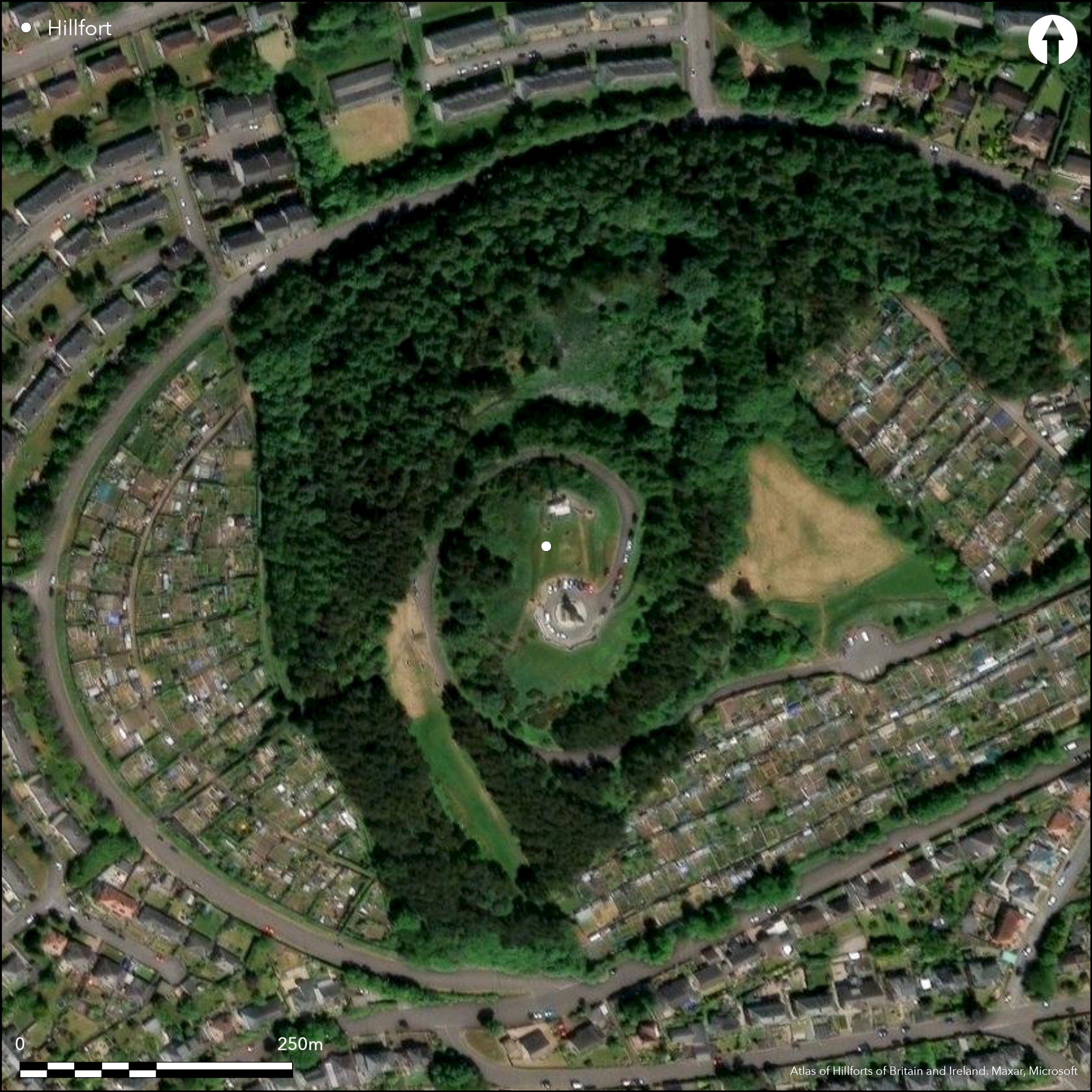
Satellite Imagery
LiDAR 1m DTM Hillshade
Satellite Imagery
Scroll left/right to view further images.
HER: City of Dundee per Canmore 31936 (None)
NMR: NO 33 SE 32 (31936)
SM: 2878
NGR: NO 3914 3131
X: 339140 Y: 731310 (OSGB36)
Little is visible of the fort that stood on the summit of Dundee Law, which was adapted in the 16th or 17th centuries for a rectangular artillery fortification, and further demolished in 1923 for the construction of a war memorial; other damage has been caused by telecommunication installations erected over the N end. Nevertheless, the first town plans surveyed for Dundee in the mid 19th century clearly depict the artillery fortification, with bastions at each of its four corners, set squarely across a subrectangular enclosure measuring in the order of 70m from N to S by 30m transversely within its rampart (0.18ha). Vitrified stones found during the construction of the war memorial and in an excavation in 1993 suggest that this earlier rampart was timber-laced, though the rampart itself was not located in 1993, when partial sections were cut across what are probably elements of the earthwork defences of the artillery fort (Driscoll 1995). An area of intense burning was located on the W side of the interior, however, returning a radiocarbon date of 770 to 370 cal BC, while a stratified sequence of deposits was also recorded in which a pit containing three sherds of 1st century AD samian ware had been cut through an earlier area of paving and sealed by another burnt deposit, in this case dating from 40 cal BC to cal AD 220. A similar spectrum was returned by three dates from internal deposits located in an earlier evaluation carried out in 1990 (Rideout 1990). The only other feature of note is that the early OS maps of Dundee Law show a scarp encircling the foot of the hill, but there is no evidence that this is an ancient enclosure and fieldwork in 1993 found only old field banks on the lower slopes (Driscoll 1995).
Citizen Science: ✗
Reliability of Data: Confirmed
Reliability of Interpretation: Confirmed
X: -332783 Y: 7652559 (EPSG: 3857)
Longitude: -2.9894442476205594 Latitude: 56.47002562775647 (EPSG:4326)
Country: Scotland
Current County or Unitary Authority: City of Dundee
Historic County: Angus
Current Parish/Community/Council/Townland: Dundee
Destroyed by various bits of construction, from an artillery fort to a war memorial and a telecommunications mast
| Extant | ✓ |
| Cropmark | ✗ |
| Likely Destroyed | ✓ |
None
| Woodland | ✓ |
| Commercial Forestry Plantation | ✗ |
| Parkland | ✓ |
| Pasture (Grazing) | ✗ |
| Arable | ✗ |
| Scrub/Bracken | ✗ |
| Bare Outcrop | ✗ |
| Heather/Moorland | ✗ |
| Heath | ✗ |
| Built-up | ✓ |
| Coastal Grassland | ✗ |
| Other | ✗ |
None
| Contour Fort | ✓ |
| Partial Contour Fort | ✗ |
| Promontory Fort | ✗ |
| Hillslope Fort | ✗ |
| Level Terrain Fort | ✗ |
| Marsh Fort | ✗ |
| Multiple Enclosure Fort | ✗ |
| Hilltop | ✓ |
| Coastal Promontory | ✗ |
| Inland Promontory | ✗ |
| Valley Bottom | ✗ |
| Knoll/Hillock/Outcrop | ✗ |
| Ridge | ✗ |
| Cliff/Plateau-edge/Scarp | ✗ |
| Hillslope | ✗ |
| Lowland | ✗ |
| Spur | ✗ |
Dominant Topographic Feature: None
| North | ✗ |
| Northeast | ✗ |
| East | ✗ |
| Southeast | ✗ |
| South | ✗ |
| Southwest | ✗ |
| West | ✗ |
| Northwest | ✗ |
| Level | ✓ |
Altitude: 174.0m
N/A
There are neither stratified artefacts nor radiocarbon dates to provide a chronology for the defences. Nevertheless an early iron age date was returned from an area of intence burning and there also three sherds of Samian ware dating from the 1st century AD
Reliability: D - None
| Pre 1200BC | ✗ |
| 1200BC - 800BC | ✗ |
| 800BC - 400BC | ✓ |
| 400BC - AD50 | ✗ |
| AD50 - AD400 | ✓ |
| AD400 - AD 800 | ✗ |
| Post AD800 | ✗ |
| Unknown | ✓ |
| Pre Hillfort: | None |
| Post Hillfort: | Overlain by artillery fort and more recently a war memorial, roads and television masts |
| C14: | Five radiocarbon dates from various contexts |
RCAHMS hold aerial views of the summit
| 1st Identified Written Reference (1793): | Noted and vitrifaction observed (Stat Acct, viii, 1793, 206) |
| 1st Identified Map Depiction (1852): | J Collies Survey of the Burgh of Dundee 1850-2 |
| Other (1857): | Annotated Fort on OS large scale plan (Dundee 1861, 54.5.7) |
| Other (1872): | Annotated Fort on the 1st edition OS 25-inch map (Forfar 1885, sheet 54.5) |
| Other (1880): | Description (Warden 1880-5, i, 52) |
| Earthwork Survey (1899): | Sketch-plan and description by David Christison (1900, 52-3, fig 14) |
| Other (1923): | S end destroyed by the construction of the war memorial |
| Other (1956): | Description for RCAHMS Survey of Marginal Lands |
| Other (1958): | Description by the OS |
| Excavation (1964): | Observations when television masts were erected on the N (Boyd 1964) |
| Other (1969): | Scheduled |
| Excavation (1990): | Evaluation (Rideout 1990) |
| Excavation (1993): | Evaluations (Driscoll 1993; 1995) |
| Earthwork Survey (1993): | Plan (Driscoll 1995, 1094, fig 2) |
Traces of occupation revealed by excavationn
None
| None | ✓ |
| Spring | ✗ |
| Stream | ✗ |
| Pool | ✗ |
| Flush | ✗ |
| Well | ✗ |
| Other | ✗ |
None
| No Known Features | ✓ |
| Round Stone Structures | ✗ |
| Rectangular Stone Structures | ✗ |
| Curvilinear Platforms | ✗ |
| Other Roundhouse Evidence | ✗ |
| Pits | ✗ |
| Quarry Hollows | ✗ |
| Other | ✗ |
Pits located (Rideout 1990) and paving and areas of intense burning (Driscoll 1995)
| No Known Excavation | ✗ |
| Pits | ✓ |
| Postholes | ✗ |
| Roundhouses | ✗ |
| Rectangular Structures | ✗ |
| Roads/Tracks | ✗ |
| Quarry Hollows | ✗ |
| Other | ✓ |
| Nothing Found | ✗ |
None
| No Known Geophysics | ✓ |
| Pits | ✗ |
| Roundhouses | ✗ |
| Rectangular Structures | ✗ |
| Roads/Tracks | ✗ |
| Quarry Hollows | ✗ |
| Other | ✗ |
| Nothing Found | ✗ |
Steatite lamp found in demolition for the war memorial in 1923. In 1993, three sherds of Samian were found, a copper alloy strip, and a copper alloy tack, a lump of iron, a flint core and a chalcedony flake, a perforated stone disc, a whale vertebra and a turned bone knob (Driscoll 1995).
| No Known Finds | ✗ |
| Pottery | ✓ |
| Metal | ✗ |
| Metalworking | ✗ |
| Human Bones | ✗ |
| Animal Bones | ✗ |
| Lithics | ✗ |
| Environmental | ✗ |
| Other | ✓ |
NO APPARENT FEATURES
| APs Not Checked | ✗ |
| None | ✓ |
| Roundhouses | ✗ |
| Rectangular Structures | ✗ |
| Pits | ✗ |
| Postholes | ✗ |
| Roads/Tracks | ✗ |
| Other | ✗ |
See main summary
| 0: | None |
| 2: | No clear evidence for the entrance into the fort |
Guard Chambers: ✗
Chevaux de Frise: ✗
At least one probably timber-laced rampart
| Area 1: | 0.18ha. |
| Total: | 0.18ha. |
Total Footprint Area: Noneha.
None
| ✗ | The rampart of the overlying artillery fortification is omitted |
| ✓ | None |
| NE Quadrant: | 1 |
| SE Quadrant: | 1 |
| SW Quadrant: | 1 |
| NW Quadrant: | 1 |
| Total: | 1 |
| Partial Univallate | ✗ |
| Univallate | ✓ |
| Partial Bivallate | ✗ |
| Bivallate | ✗ |
| Partial Multivallate | ✗ |
| Multivallate | ✗ |
| Unknown | ✗ |
| Partial Univallate | ✗ |
| Univallate | ✗ |
| Partial Bivallate | ✗ |
| Bivallate | ✗ |
| Partial Multivallate | ✗ |
| Multivallate | ✗ |
None
| None | ✗ |
| Earthen Bank | ✗ |
| Stone Wall | ✓ |
| Rubble | ✗ |
| Wall-walk | ✗ |
| Evidence of Timber | ✗ |
| Vitrification | ✗ |
| Other Burning | ✗ |
| Palisade | ✗ |
| Counter Scarp Bank | ✗ |
| Berm | ✗ |
| Unfinished | ✗ |
| Other | ✗ |
Possible faces of the rampart observed in a cable trench in 1964 (Boyd 1964). Area of intense burning found in 1993, when further pieces of vitrifaction were recovered from secondary contexts (Driscoll 1995).
| None | ✗ |
| Earthen Bank | ✗ |
| Stone Wall | ✓ |
| Murus Duplex | ✗ |
| Timber-framed | ✗ |
| Timber-laced | ✗ |
| Vitrification | ✓ |
| Other Burning | ✓ |
| Palisade | ✗ |
| Counter Scarp Bank | ✗ |
| Berm | ✗ |
| Unfinished | ✗ |
| No Known Excavation | ✗ |
| Other | ✗ |
| ✗ | None |
| ✗ | None |
Number of Ditches: None
| ✗ | None |
Boyd, J D (1964) 'Dundee Law'. Disc Exc Scot (1964, 1
Christison, D (1900) 'The forts, "camps", and other field-works of Perth, Forfar and Kincardine'. Proc Soc Antiq Scot 34 (1899-1900), 43-120
Driscoll, S T (1993) 'Dundee Law (Dundee parish): multi-period Iron Age/Roman, medieval, industrial'. Disc Exc Scot (1993), 97
Driscoll, S T (1995) 'Excavations on Dundee Law, 1993'. Proc Soc Antiq Scot 125 (1995), 1091-1108
Rideout, J S (1990) 'Dundee Law (Dundee parish), fort'. Disc Exc Scot (1990), 39
Stat Acct (date) Statistical Account of Scotland: Drawn up from the Communications of the Ministers of the Different Parishes (Sinclair, J ed), 1791-99
Warden, A J (1880-5) Angus or Forfarshire: the land and people, descriptive and historical (5v). Dundee
Atlas of Hillforts:
Wikidata:
This work is licensed under CC BY-SA 4.0![]()
![]()
![]() and should be cited as:
and should be cited as:
Lock, Gary and Ralston, Ian. 2024. Atlas of Hillforts of Britain and Ireland. Available at: https://hillforts.arch.ox.ac.uk
Document Version 1.1