Satellite Imagery
Satellite Imagery
HER: Angus SMR per Aberdeenshire Council NO34SW0007 (None)
NMR: NO 34 SW 7 (32170)
SM: 3219
NGR: NO 3227 4177
X: 332270 Y: 741770 (OSGB36)
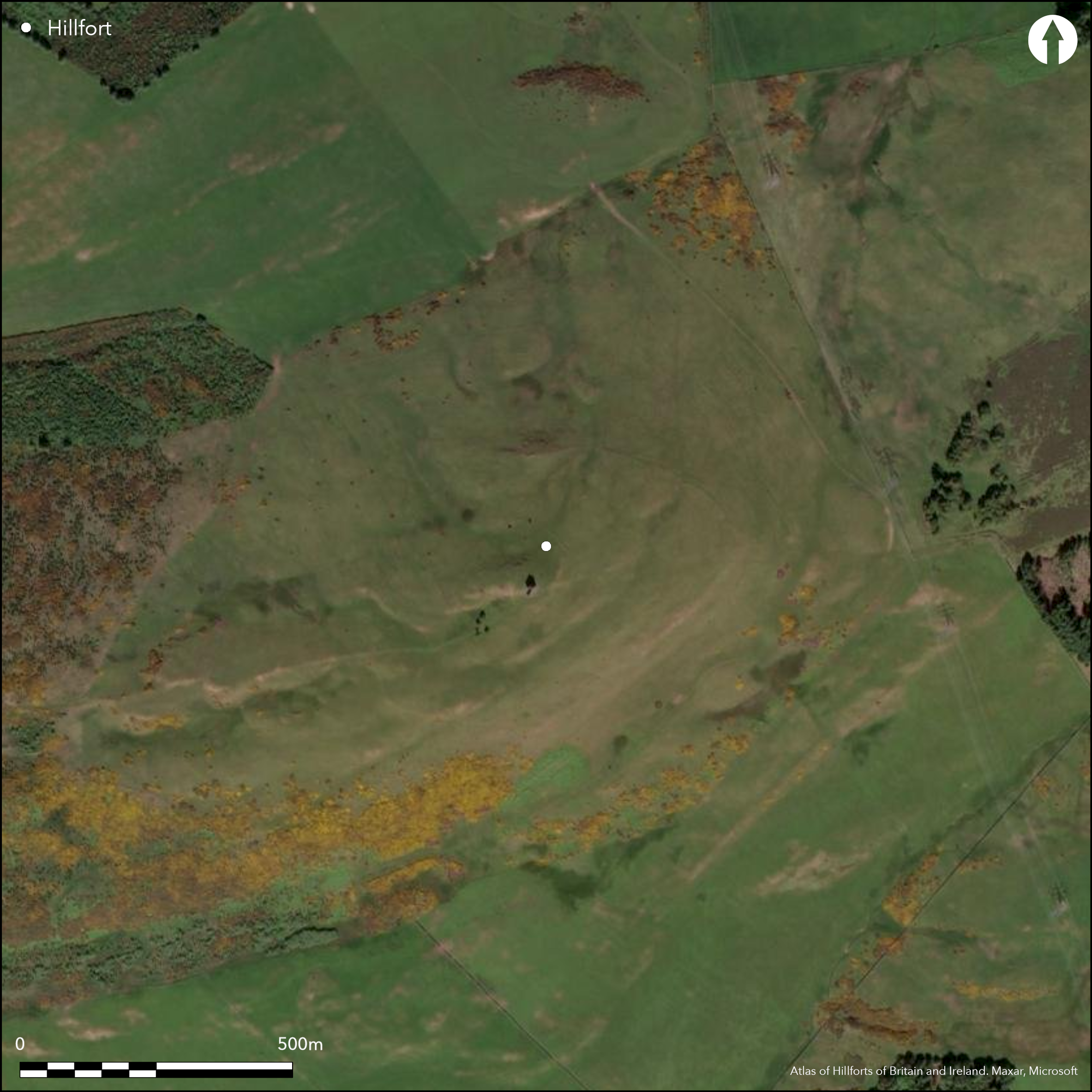
This fort is situated on Kinpurney Hill, which is crowned by the shell of an observatory tower built in 1774, from which it was claimed in 1791 that St Abbs Head, Berwickshire could be seen, along with parts of ten or eleven separate counties (Stat Acct, iii, 1791, 403). Roughly oval on plan, the interior of the fort measures about 360m from NE to SW by 240m transversely (6.83ha). The defences comprise a single rampart accompanied by an external ditch, though at best these are reduced to a scarp dropping some 2m to a narrow terrace, and along the lip of the rocky slope along the SE flank there is little trace of either. Nevertheless, at least four probable entrances can be identified on the NNE, NE, WSW and WNW respectively, of which that on the NE has possible traces of short inturns to either side of a trackway leading up into the interior, while that on the WSW forms a deep re-entrant where the rampart turns inwards to either side of a shallow natural gully apparently facing towards Schiehallion, a distant summit that can be discerned on the horizon some 60km to the WNW; the other two gaps are also in shallow gullies. No clear stances for timber round-houses are visible within the interior, and apart from the tower on the summit the only other feature is a roughly square plantation enclosure of about 1.35ha surrounding it. The ephemeral character of the defences led Richard Feachem to suggest the fort was unfinished, but the slight stature of the rampart in general, and its apparent absence along the SE flank, is entirely in keeping with other large hilltop enclosures and the circuit is probably much as the builders intended it.
Citizen Science: ✗
Reliability of Data: Confirmed
Reliability of Interpretation: Confirmed
X: -345498 Y: 7671328 (EPSG: 3857)
Longitude: -3.1036608166094566 Latitude: 56.56304350799813 (EPSG:4326)
Country: Scotland
Current County or Unitary Authority: Angus
Historic County: Angus
Current Parish/Community/Council/Townland: Newtyle
None
| Extant | ✓ |
| Cropmark | ✗ |
| Likely Destroyed | ✗ |
None
| Woodland | ✗ |
| Commercial Forestry Plantation | ✗ |
| Parkland | ✗ |
| Pasture (Grazing) | ✓ |
| Arable | ✗ |
| Scrub/Bracken | ✗ |
| Bare Outcrop | ✗ |
| Heather/Moorland | ✓ |
| Heath | ✗ |
| Built-up | ✗ |
| Coastal Grassland | ✗ |
| Other | ✗ |
None
| Contour Fort | ✓ |
| Partial Contour Fort | ✗ |
| Promontory Fort | ✗ |
| Hillslope Fort | ✗ |
| Level Terrain Fort | ✗ |
| Marsh Fort | ✗ |
| Multiple Enclosure Fort | ✗ |
| Hilltop | ✓ |
| Coastal Promontory | ✗ |
| Inland Promontory | ✗ |
| Valley Bottom | ✗ |
| Knoll/Hillock/Outcrop | ✗ |
| Ridge | ✗ |
| Cliff/Plateau-edge/Scarp | ✗ |
| Hillslope | ✗ |
| Lowland | ✗ |
| Spur | ✗ |
Dominant Topographic Feature: None
| North | ✗ |
| Northeast | ✗ |
| East | ✗ |
| Southeast | ✗ |
| South | ✗ |
| Southwest | ✗ |
| West | ✗ |
| Northwest | ✗ |
| Level | ✓ |
Altitude: 345.0m
N/A
In the absence of excavation, there are neither stratified artefacts nor radiocarbon dates to provide a chronology for the defences.
Reliability: D - None
| Pre 1200BC | ✗ |
| 1200BC - 800BC | ✗ |
| 800BC - 400BC | ✗ |
| 400BC - AD50 | ✗ |
| AD50 - AD400 | ✗ |
| AD400 - AD 800 | ✗ |
| Post AD800 | ✗ |
| Unknown | ✓ |
| Pre Hillfort: | None |
| Post Hillfort: | A tower built in 1744 as an observatory stands on the summit |
None
| 1st Identified Written Reference (1956): | Discovered during RCAHMS Survey of Marginal Lands (Feachem 1966, 70) |
| 1st Identified Map Depiction (1967): | Surveyed at 1:2500 by the OS |
| Other (1972): | Scheduled |
| Other (1983): | Description by RCAHMS |
| Other (1999): | Description by Ian Ralston in Angus SMR |
| Other (2015): | Re-Scheduled |
Several level areas but no clearly defined house platforms
None
| None | ✓ |
| Spring | ✗ |
| Stream | ✗ |
| Pool | ✗ |
| Flush | ✗ |
| Well | ✗ |
| Other | ✗ |
Partly under old plantation
| No Known Features | ✓ |
| Round Stone Structures | ✗ |
| Rectangular Stone Structures | ✗ |
| Curvilinear Platforms | ✗ |
| Other Roundhouse Evidence | ✗ |
| Pits | ✗ |
| Quarry Hollows | ✗ |
| Other | ✗ |
None
| No Known Excavation | ✓ |
| Pits | ✗ |
| Postholes | ✗ |
| Roundhouses | ✗ |
| Rectangular Structures | ✗ |
| Roads/Tracks | ✗ |
| Quarry Hollows | ✗ |
| Other | ✗ |
| Nothing Found | ✗ |
None
| No Known Geophysics | ✓ |
| Pits | ✗ |
| Roundhouses | ✗ |
| Rectangular Structures | ✗ |
| Roads/Tracks | ✗ |
| Quarry Hollows | ✗ |
| Other | ✗ |
| Nothing Found | ✗ |
None
| No Known Finds | ✓ |
| Pottery | ✗ |
| Metal | ✗ |
| Metalworking | ✗ |
| Human Bones | ✗ |
| Animal Bones | ✗ |
| Lithics | ✗ |
| Environmental | ✗ |
| Other | ✗ |
NO APPARENT FEATURES
| APs Not Checked | ✗ |
| None | ✓ |
| Roundhouses | ✗ |
| Rectangular Structures | ✗ |
| Pits | ✗ |
| Postholes | ✗ |
| Roads/Tracks | ✗ |
| Other | ✗ |
See main summary
| 4: | None |
| 2: | None |
Guard Chambers: ✗
Chevaux de Frise: ✗
| 1. Simple Gap (North east): | None |
| 2. In-turned (North east): | Possible inturns to either side |
| 3. In-turned (South west): | Forms a deep re-entrant |
| 4. Simple Gap (North west): | None |
Single rampart and ditch around most of the circuit
| Area 1: | 6.83ha. |
| Total: | 6.83ha. |
Total Footprint Area: Noneha.
None
| ✗ | None |
| ✗ | None |
| NE Quadrant: | 1 |
| SE Quadrant: | 0 |
| SW Quadrant: | 1 |
| NW Quadrant: | 1 |
| Total: | 1 |
| Partial Univallate | ✓ |
| Univallate | ✗ |
| Partial Bivallate | ✗ |
| Bivallate | ✗ |
| Partial Multivallate | ✗ |
| Multivallate | ✗ |
| Unknown | ✗ |
| Partial Univallate | ✗ |
| Univallate | ✗ |
| Partial Bivallate | ✗ |
| Bivallate | ✗ |
| Partial Multivallate | ✗ |
| Multivallate | ✗ |
Claimed as unfinished, and a piece of stone in Brechin Museum labelled Kinpurney Hill is claimed to be vitrified. Neither is convincing in the light of the evidence on the ground.
| None | ✗ |
| Earthen Bank | ✓ |
| Stone Wall | ✗ |
| Rubble | ✗ |
| Wall-walk | ✗ |
| Evidence of Timber | ✗ |
| Vitrification | ✓ |
| Other Burning | ✗ |
| Palisade | ✗ |
| Counter Scarp Bank | ✗ |
| Berm | ✗ |
| Unfinished | ✓ |
| Other | ✗ |
None
| None | ✗ |
| Earthen Bank | ✗ |
| Stone Wall | ✗ |
| Murus Duplex | ✗ |
| Timber-framed | ✗ |
| Timber-laced | ✗ |
| Vitrification | ✗ |
| Other Burning | ✗ |
| Palisade | ✗ |
| Counter Scarp Bank | ✗ |
| Berm | ✗ |
| Unfinished | ✗ |
| No Known Excavation | ✓ |
| Other | ✗ |
| ✗ | None |
| ✓ | None |
Number of Ditches: 1
| ✗ | None |
Feachem, R W (1966) 'The hill-forts of northern Britain'. In Rivet, A L F (ed) The iron age in northern Britain. Edinburgh University Press: Edinburgh
Stat Acct (date) Statistical Account of Scotland: Drawn up from the Communications of the Ministers of the Different Parishes (Sinclair, J ed), 1791-99
Atlas of Hillforts:
Wikidata:
This work is licensed under CC BY-SA 4.0![]()
![]()
![]() and should be cited as:
and should be cited as:
Lock, Gary and Ralston, Ian. 2024. Atlas of Hillforts of Britain and Ireland. Available at: https://hillforts.arch.ox.ac.uk
Document Version 1.1