Satellite Imagery
Satellite Imagery
HER: Aberdeenshire Historic Environment Record NO49NW0006 (None)
NMR: NO 49 NW 11 (33979)
SM: None
NGR: NO 4442 9900
X: 344420 Y: 799000 (OSGB36)
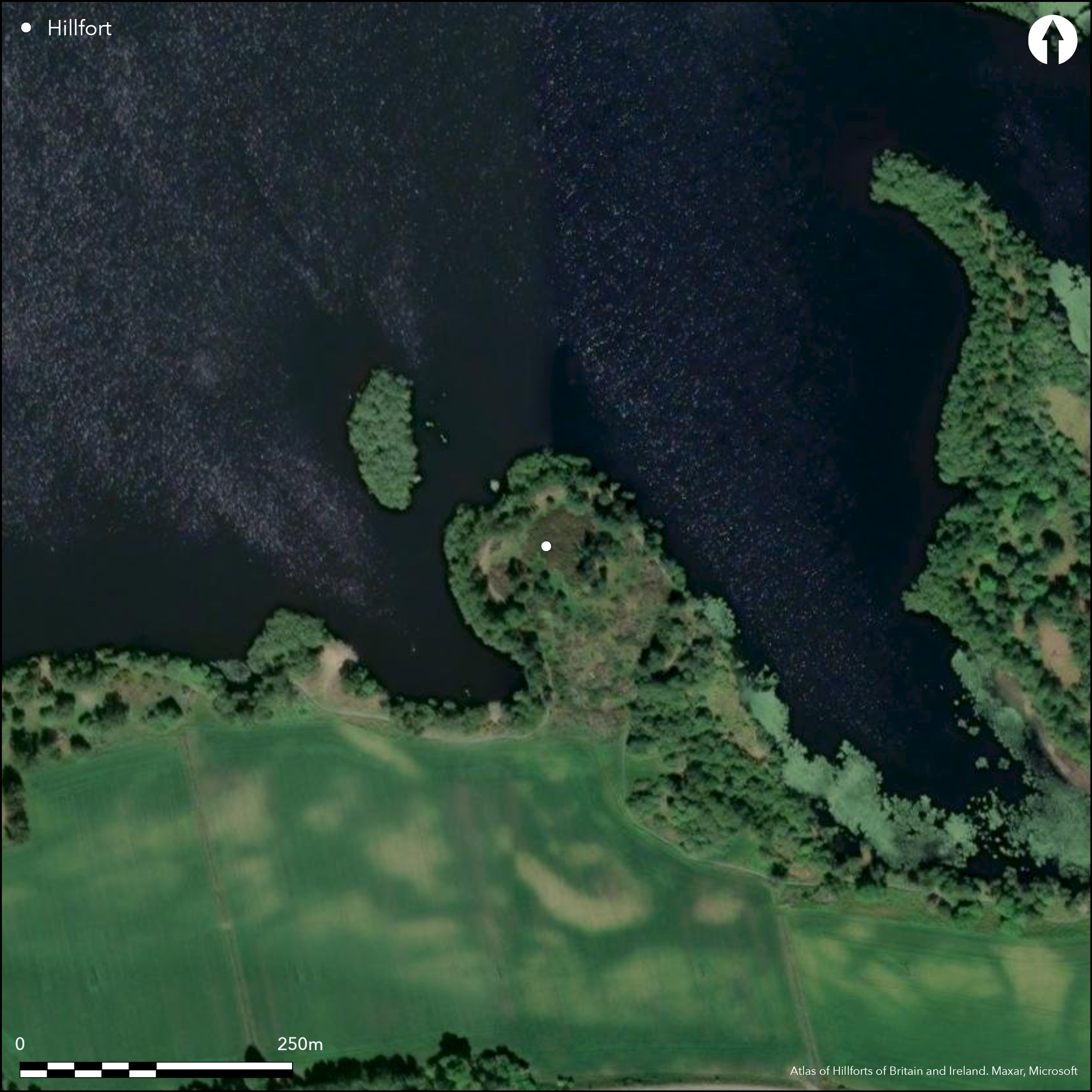
This low-lying promontory jutting out from the southern shore of Loch Kinord has been cut off from the land on the S by a bank with external ditch drawn in an arc across its neck. The bank is capped by a collapsed stone dyke and stands up to 3m above the bottom of the ditch, the counterscarp of which is also revetted by a later dyke. The interior, which measures about 95m from NNW to SSE by up to 85m transversely (0.6ha), contains footings of two rectangular buildings. According to John Stuart, writing in the mid 19th century, there had been a metalled roadway leading to what he took to be a drawbridge across the ditch (1866, 169-70). Most recently two small trenches were excavated across elements of the perimeter (Stratigos 2015), but failed to elucidate anything of the date or character of this earthwork.
Citizen Science: ✗
Reliability of Data: Confirmed
Reliability of Interpretation: Unconfirmed
X: -324884 Y: 7776224 (EPSG: 3857)
Longitude: -2.918486962928425 Latitude: 57.07871095675655 (EPSG:4326)
Country: Scotland
Current County or Unitary Authority: Aberdeenshire
Historic County: Aberdeenshire
Current Parish/Community/Council/Townland: Glenmuick, Tullich And Deeside
None
| Extant | ✓ |
| Cropmark | ✗ |
| Likely Destroyed | ✗ |
None
| Woodland | ✓ |
| Commercial Forestry Plantation | ✗ |
| Parkland | ✗ |
| Pasture (Grazing) | ✓ |
| Arable | ✗ |
| Scrub/Bracken | ✓ |
| Bare Outcrop | ✗ |
| Heather/Moorland | ✓ |
| Heath | ✗ |
| Built-up | ✗ |
| Coastal Grassland | ✗ |
| Other | ✗ |
None
| Contour Fort | ✗ |
| Partial Contour Fort | ✗ |
| Promontory Fort | ✓ |
| Hillslope Fort | ✗ |
| Level Terrain Fort | ✗ |
| Marsh Fort | ✗ |
| Multiple Enclosure Fort | ✗ |
| Hilltop | ✗ |
| Coastal Promontory | ✗ |
| Inland Promontory | ✓ |
| Valley Bottom | ✗ |
| Knoll/Hillock/Outcrop | ✗ |
| Ridge | ✗ |
| Cliff/Plateau-edge/Scarp | ✗ |
| Hillslope | ✗ |
| Lowland | ✗ |
| Spur | ✗ |
Dominant Topographic Feature: None
| North | ✗ |
| Northeast | ✗ |
| East | ✗ |
| Southeast | ✗ |
| South | ✗ |
| Southwest | ✗ |
| West | ✗ |
| Northwest | ✗ |
| Level | ✓ |
Altitude: 165.0m
N/A
There are neither stratified artefacts nor radiocarbon dates to provide a chronology for the defences.
Reliability: D - None
| Pre 1200BC | ✗ |
| 1200BC - 800BC | ✗ |
| 800BC - 400BC | ✗ |
| 400BC - AD50 | ✗ |
| AD50 - AD400 | ✗ |
| AD400 - AD 800 | ✗ |
| Post AD800 | ✗ |
| Unknown | ✓ |
| Pre Hillfort: | None |
| Post Hillfort: | Interior contains two rectangular buildings |
None
| 1st Identified Written Reference (1866): | Description (Stuart 1866, 169-70) |
| Other (1910): | Description by Sir Alexander Ogston (1931, 29; Michie 1910, 96) |
| 1st Identified Map Depiction (1969): | Surveyed at 1:2500 by the OS |
| Excavation (2015): | By M Stratigos of Aberdeen Unibersity (https://scottishcrannogs.wordpress.com/) |
The footings of two rectangular buildings
None
| None | ✓ |
| Spring | ✗ |
| Stream | ✗ |
| Pool | ✗ |
| Flush | ✗ |
| Well | ✗ |
| Other | ✗ |
None
| No Known Features | ✗ |
| Round Stone Structures | ✗ |
| Rectangular Stone Structures | ✓ |
| Curvilinear Platforms | ✗ |
| Other Roundhouse Evidence | ✗ |
| Pits | ✗ |
| Quarry Hollows | ✗ |
| Other | ✗ |
None
| No Known Excavation | ✓ |
| Pits | ✗ |
| Postholes | ✗ |
| Roundhouses | ✗ |
| Rectangular Structures | ✗ |
| Roads/Tracks | ✗ |
| Quarry Hollows | ✗ |
| Other | ✗ |
| Nothing Found | ✗ |
None
| No Known Geophysics | ✓ |
| Pits | ✗ |
| Roundhouses | ✗ |
| Rectangular Structures | ✗ |
| Roads/Tracks | ✗ |
| Quarry Hollows | ✗ |
| Other | ✗ |
| Nothing Found | ✗ |
None
| No Known Finds | ✓ |
| Pottery | ✗ |
| Metal | ✗ |
| Metalworking | ✗ |
| Human Bones | ✗ |
| Animal Bones | ✗ |
| Lithics | ✗ |
| Environmental | ✗ |
| Other | ✗ |
NO APPARENT FEATURES
| APs Not Checked | ✗ |
| None | ✗ |
| Roundhouses | ✗ |
| Rectangular Structures | ✓ |
| Pits | ✗ |
| Postholes | ✗ |
| Roads/Tracks | ✗ |
| Other | ✗ |
See main summary
| 0: | None |
| 2: | None known |
Guard Chambers: ✗
Chevaux de Frise: ✗
Single bank and ditch
| Area 1: | 0.6ha. |
| Total: | 0.6ha. |
Total Footprint Area: Noneha.
None
| ✓ | Bank and ditch overlain by later enclosure walls adopting the same line |
| ✓ | None |
| NE Quadrant: | 0 |
| SE Quadrant: | 0 |
| SW Quadrant: | 1 |
| NW Quadrant: | 0 |
| Total: | 1 |
| Partial Univallate | ✓ |
| Univallate | ✗ |
| Partial Bivallate | ✗ |
| Bivallate | ✗ |
| Partial Multivallate | ✗ |
| Multivallate | ✗ |
| Unknown | ✗ |
| Partial Univallate | ✗ |
| Univallate | ✗ |
| Partial Bivallate | ✗ |
| Bivallate | ✗ |
| Partial Multivallate | ✗ |
| Multivallate | ✗ |
None
| None | ✗ |
| Earthen Bank | ✓ |
| Stone Wall | ✗ |
| Rubble | ✗ |
| Wall-walk | ✗ |
| Evidence of Timber | ✗ |
| Vitrification | ✗ |
| Other Burning | ✗ |
| Palisade | ✗ |
| Counter Scarp Bank | ✗ |
| Berm | ✗ |
| Unfinished | ✗ |
| Other | ✗ |
and ditch
| None | ✗ |
| Earthen Bank | ✓ |
| Stone Wall | ✗ |
| Murus Duplex | ✗ |
| Timber-framed | ✗ |
| Timber-laced | ✗ |
| Vitrification | ✗ |
| Other Burning | ✗ |
| Palisade | ✗ |
| Counter Scarp Bank | ✗ |
| Berm | ✗ |
| Unfinished | ✗ |
| No Known Excavation | ✗ |
| Other | ✓ |
| ✗ | None |
| ✓ | None |
Number of Ditches: 1
| ✗ | None |
Michie, J G (1910) Loch Kinnord: its history and antiquities. New and revised edition. Aberdeen
Ogston, A (1931) The prehistoric antiquities of the Howe of Cromar. (Simpson, W D ed) Third Spalding Club:Aberdeen
Stratigos. M (2015) 'Excavation at the Gardiebane Peninsula. https://scottishcrannogs.wordpress.com/
Stuart, J (1868) 'Notice of a group of artificial islands in the Loch of Dowalton, Wigtonshire, and of other artificial islands or "Crannogs" throughout Scotland'. Proc Soc Antiq Scot 6 (1864-66), 114-78
Atlas of Hillforts:
Wikidata:
This work is licensed under CC BY-SA 4.0![]()
![]()
![]() and should be cited as:
and should be cited as:
Lock, Gary and Ralston, Ian. 2024. Atlas of Hillforts of Britain and Ireland. Available at: https://hillforts.arch.ox.ac.uk
Document Version 1.1